Trips Through and Around the Monument[34]
Reading edition
Trips Through and Around the Monument[34]
From Grand Junction through the Redlands to the West Entrance of the Monument
STARTING POINT
1
We will begin our trip in the southwestern part of Grand Junction at the intersection of First Street and Grand Avenue, (this is also the intersection of U.S. Highways 6 and 50 and Colorado Highway 340), by following a sign on Highway 340 pointing westward toward the Monument. After crossing a viaduct over the railroad yards and a bridge across the Colorado River, we come to a traffic light and a sign pointing left toward the Monument. The road to the left connects with Monument Road which leads up No Thoroughfare Canyon to the East Entrance. However, we will continue westward toward The Redlands.
REDLANDS CANAL
2
Just beyond the stoplight we cross a bridge over the Redlands Power Canal which carries 675 cubic feet per second (cfs, or ft³s⁻¹)[35] from the Redlands Diversion Dam on the Gunnison River about 2½ miles south of Grand Junction. A quarter of a mile northwest of the bridge, most of the water falls to a lower powerplant that generates electricity for pumping the remaining 50 cfs to three lift canals, which are used mainly for irrigating peach orchards in the eastern part of The Redlands.
89
SOUTH BROADWAY
3
After Colorado Highway 340 curves right it is known as Broadway—a paved road serving much of The Redlands and connecting with the West Entrance of the Monument. We will follow Broadway about 3 miles, passing low outcrops and roadcuts of the Dakota Sandstone, some of which contain coal beds and some of which are covered by a veneer of gravel laid down by the river when the channel was higher. Then, at the first store and filling station we turn southwest on another paved road known as South Broadway.
SOUTH CAMP ROAD SIDE TRIP
4
Just around the curve to the right is a T-intersection from which paved South Camp Road leads south to a growing suburban area; and 2½ miles to the southeast it connects with Monument Road at a point only half a mile north of the East Entrance of the Monument.
Excellent views of the cliffs of dark Proterozoic rocks, the overlying cliffs of the Wingate Sandstone, and the Redlands fault along the northeastern border of the Monument are seen all along South Broadway, but views from South Camp Road and several connecting roads to the southwest are especially good. (See figs. 37 and 38.) As noted earlier, the Redlands fault has a maximum vertical displacement of 700 or 800 feet, but dies out in scissors fashion at each end.
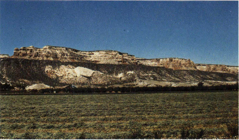
REDLANDS FAULT, looking west from South Camp Road about one mile south of South Broadway. Fault here is nearly vertical and normal, and lies between updragged Wingate Sandstone and dark Proterozoic schist, gneiss, and granite. All or most of the soft Chinle Formation has been squeezed out along the fault. Note smooth erosion surface atop hard, dark rocks surmounted by slope of red Chinle Formation and cliffs of Wingate Sandstone capped by lowermost resistant beds of Kayenta Formation. (Fig. 37)
90
BRACHIOSAURUS MONUMENT
5
As we continue westward on South Broadway, note on the right the brightly colored mudstone and siltstone of the Brushy Basin Member of the Morrison Formation strewn with large blocks of rusty-looking sandstone from the Burro Canyon Formation, which caps the high ridge on the right. Just above the deep cut on the right four-tenths of a mile west of the intersection with South Camp Road is a bronze plaque set in a masonry monument, whose lettering is easily readable in figure 39. Many years after the excavation in 1900 (fig. 22), Elmer Riggs contacted Al Look, of Grand Junction, in regard to the casting and erection of this plaque. Al, Elmer, Ed Faber, and a few other citizens put up the necessary funds and personally erected the plaque and monument. Somehow or other, Brachiosaurus was misspelled Brachyosaurus, as shown in figure 39, but the intentions were good. Later I will call attention to another similar monument commemorating the finding by Riggs of another dinosaur skeleton.
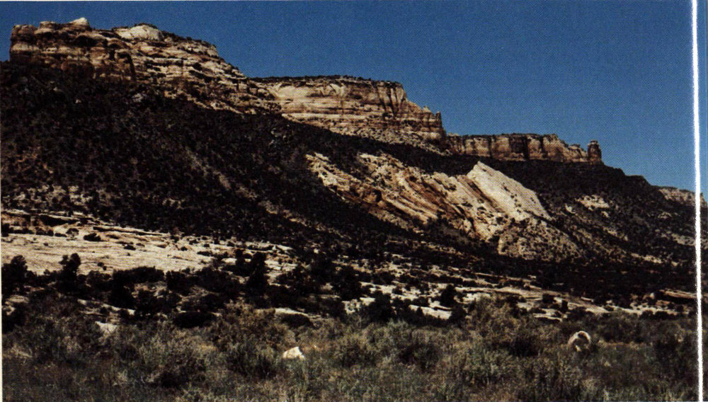
CLOSEUP OF UPDRAGGED WINGATE SANDSTONE ALONG REDLANDS FAULT, looking northwest from side road 1½ miles southwest of intersection of South Camp Road and South Broadway. White “pimple” atop cliff near left skyline is Liberty Cap, an erosional remnant of the Wingate Sandstone, reachable via the Liberty Cap Trail (fig. 3; and p. 108). Chinle Formation here was largely squeezed out along the fault. (Fig. 38)
WATCH TURNS
After a sharp turn to the north and another to the west, South Broadway reaches the top of a hill just above the Elk’s Club and curves gently to the right past sandstone lenses in the Salt Wash Member of the Morrison Formation. A 610-foot-deep 91 well at the house on the left formerly flowed about 1½ gallons a minute from the Entrada and Wingate Sandstones.
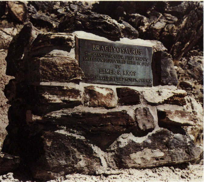
BRONZE PLAQUE AND MONUMENT MARKING THE DISCOVERY OF BRACHIOSAURUS ALTITHORAX RIGGS, above roadcut on South Broadway four-tenths of a mile west of South Camp Road. See also figure 22. For discrepancy in spelling text. (Fig. 39)
LEFT TURN
WATCH FOR BUFFALO
6
Half a mile to the north, South Broadway turns sharply to the left even though another paved road continues northward. Three-fourths of a mile to the west, we turn northwestward parallel to the Monument boundary fence for seven-tenths of a mile before turning north again. The 7-foot chain-link fence just to the left of the road is the northeastern boundary of the Monument and encloses the herd of buffalo. In the late forties or early fifties a young bull challenged the older leader for possession of the herd and gored and pounded the old bull so badly he had to be shot by a ranger. During the furious battle 125 feet of this strong steel fence was utterly demolished. It is reported that sometimes an old bull simply takes one look at the young challenger and retreats without a battle, but other lone or rogue bulls may temporarily or permanently leave the herd for other reasons. Such outcasts are dangerous and unpredictable. One bull kept a ranger “treed” for 4 hours on a steep rock ledge in the broiling sun before moving on to a patch 92 of grass. Four of these critters delayed by one week my walking out a stretch of the Redlands fault on their side of the fence. I decided that a live geologist had advantages over a dead hero.
REDLANDS FAULT
WINGATE DRIVE SIDE TRIP
7
Throughout most of its 6-mile length the Redlands fault is a vertical or nearly vertical normal fault, but along and near this 0.7-mile stretch it is a reverse fault that dips from 45° to 60° to the southwest, as shown in figure 40 and in the cross section of figure 8. Good views of the fault are seen all along the fence, but especially at points one-tenth and four-tenths of a mile northwest of the first turn, the second of which is shown in figure 40. Just after turning north on South Broadway, let us turn west a few hundred feet on paved Wingate Drive to see the northwest end of the Redlands fault, which passes through a col to the left of updragged remnants of the thinned red Chinle Formation and the Wingate Sandstone, as shown in figure 41.
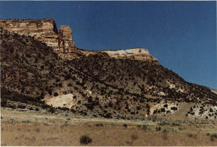
REVERSE PART OF REDLANDS FAULT, looking N. 65° W. from point on South Broadway along boundary fence. Most of Chinle Formation has been squeezed out, but lower part of Wingate Sandstone may be seen dipping about 45° southwestward beneath dark Proterozoic rocks. Next pink band to right is Entrada Sandstone. Jumbled mass of white sandstone slabs at right of photograph is part of Salt Wash Member of Morrison Formation and is known locally as “White Rock”. (Fig. 40)
93
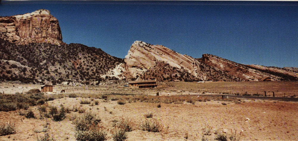
NORTHWEST END OF REDLANDS FAULT, passing through col to left of updragged remnants of Chinle Formation and Wingate Sandstone. Fault, which here is normal, ends against unbroken Lizard Canyon monocline in next canyon to northwest. Looking west from point just south of Wingate Drive a few hundred feet west of South Broadway. (Fig. 41)
94
MONUMENT CANYON TRAIL
About half a mile north of the last turn, South Broadway rejoins Broadway (Colo. Highway 340) at a stop sign. After we turn left on Broadway and reach the first curve, we get a nice view westward into Monument Canyon, as shown in figure 42. The Park Service hopes to establish a new trailhead at the bridge one-tenth of a mile west of the curve, from which a new section of trail will follow the normally dry wash southwestward to join the old Monument Canyon Trail. After we cross the creek leaving the canyon, we pass a low hill of the Salt Wash Member of the Morrison Formation on the left. Just beyond the hill, the dirt road leading southwest to a farmhouse formerly was the beginning of the Monument Canyon Trail (fig. 3). There is a new temporary trailhead a quarter of a mile north, but it is hoped that a permanent one can be built at the bridge about a quarter of a mile to the southeast, as noted above. Hikers may see buffalo along this trail and should watch out for outcast bulls.
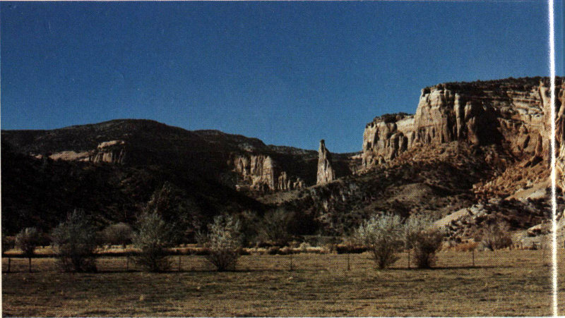
LOOKING WEST INTO MONUMENT CANYON, from curve on Broadway just northwest of end of South Broadway, showing Independence Monument. This monument was seen in figure 6 and will be seen again in figure 51. Redlands fault ends in this canyon; Lizard Canyon monocline can be seen on extreme right. (Fig. 42)
DRAINAGE DIVIDE
8
About half a mile north of the farm road we reach the highest point on Broadway (Colo. 340) at a drainage divide. Inasmuch as the three Redlands Lift Canals end east of the divide, there is quite a contrast between the lush irrigated lands east of the divide and the nearly barren desert to the west, a view of which 95 is shown in figure 43. To the southwest of the divide is an excellent view of the northeastward-dipping beds on the Lizard Canyon monocline. On the left about a mile northwest of the divide we pass the other entrance of Monument Canyon, then Lizard Canyon, and a switchback on Rim Rock Drive ascending the ridge between Lizard and Fruita Canyons. The water well beneath elevated tank on left is 650 feet deep and formerly flowed at about half a gallon a minute from the Wingate Sandstone. Household needs are obtained by pumping.
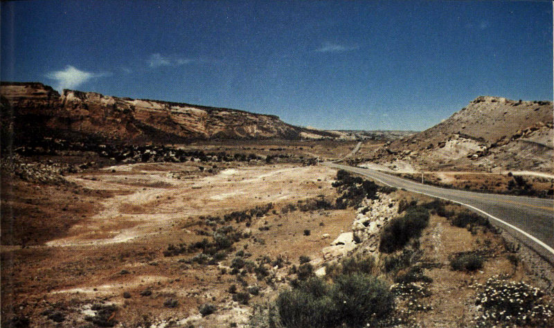
LOOKING WEST FROM DIVIDE ON BROADWAY 2 MILES EAST OF WEST ENTRANCE TO MONUMENT. Monoclinal hill on right is Brushy Basin Member of Morrison Formation capped by basal beds of Burro Canyon Formation. Rocks at left middle are blocks of sandstone in the Salt Wash Member of the Morrison. (Fig. 43)
ROAD INTERSECTION
At the next intersection, Colorado Highway 340 turns right and continues about 2½ miles to Fruita; the highway to the left reaches the West Entrance of the Monument in a quarter of a mile. Before turning left into the Monument, however, we will interrupt our description of the trip by making a new start from Fruita for the benefit of people travelling from this direction.
96
From Fruita to the West Entrance of the Monument

MORRISON FORMATION
9
From the Fruita interchange on I-70, the overpass leads north into the town of Fruita, and Colorado Highway 340 leads south about 2½ miles to the West Entrance of Colorado National Monument. One mile south we cross the new bridge over the Colorado River; the old bridge formerly connecting Fruita with the Monument may be seen half a mile upstream. Just south of the new bridge we see sandstone on the left and green shale on the right, both part of the Burro Canyon Formation. The high hill on the left is made up of brightly colored siltstones and mudstones of the Brushy Basin Member of the Morrison Formation capped by the basal sandstone of the Burro Canyon Formation. On the southeast side of this hill is another bronze plaque set in a masonry monument, similar to the one at Riggs Hill (fig. 39), commemorating the discovery and removal in 1900 by Elmer S. Riggs of a skeleton of the immense dinosaur Apatosaurus excelcus Marsh. (See figure 23B). About 1¾ miles northwest of the new bridge is the Fruita Paleontological area discussed on page 50.
Just south of the hill, the highway curves gently to the left across a relatively flat surface of the Morrison Formation. To the right may be seen good exposures of the Entrada Sandstone, at the north end of which curbstones were quarried from thin beds of the white Moab Member for use in some of the parking areas along Rim Rock Drive. Some of the beds are ripple marked[36] from wave action along ancient beaches or within ancient lagoons. Some ripple-marked curbstones from this quarry may be seen in the parking area at Red Canyon Overlook, and elsewhere in the Monument.
As we approach the Monument we see that to the left the rock strata are bent downward toward us along what geologists call a monocline (see figs. 27 and 30), but to the right may be seen cliffs of dark Proterozoic rocks surmounted by slopes of the red Chinle Formation and cliffs of the buff Wingate Sandstone capped by the lowermost beds of the 97 resistant Kayenta Formation. The bent and broken rocks ahead are well shown in figure 33.
About 1½ miles south of the Colorado River we reach the T-intersection noted previously—at the end of the trip from Grand Junction through The Redlands to the West Entrance of the Monument—and we are ready for our trip through the Monument.
Through the Monument from West to East Entrances
WEST ENTRANCE
10
After turning south on Rim Rock Drive from the intersection with Colorado Highway 340 (Broadway), we cross the Monument’s northern boundary and reach the checking station at the West Entrance, where a small entry fee is charged during the summer. At the first left turn we are in red beds of the Chinle Formation, then in sheared and broken beds of the Wingate Sandstone along the Kodels Canyon fault. At the easternmost loop of the road we may look southeastward across Lizard Canyon to the Lizard Canyon monocline (fig. 30), and if we look down the slope to the east we will see one of John Otto’s well-built trails that formerly ascended the west side of Lizard Canyon to what is now the campground, long before Rim Rock Drive was built. Do not try to stop at the curve, however; play it safe, drive on, and park at Redlands View a quarter of a mile west.
REDLANDS VIEW
By walking about 50 feet north of the turnout, we get an excellent view to the west of the Kodels Canyon fault, as shown in figure 31. Just to the north of the fault are the sheared and broken beds of the Wingate Sandstone along the east end of this fault.
NEW EARTHFILL
Just beyond the turnout the road curves left through a cut in the Wingate Sandstone and ascends the east side of Fruita Canyon. About a quarter of a mile from the parking area we get a good view (fig. 44) to the west of the new earthfill on Rim Rock Drive between the two tunnels. The original fill was washed out in a few minutes on August 8, 1968, by a cloudburst that dumped an estimated 4 inches of rain on the mesa west of Fruita Canyon. A culvert beneath the road just north of the north tunnel was wholly unable to cope with the resulting flood, part of which plunged over the cliff but most of which roared southward through the tunnel. According to the only known eyewitnesses—a couple from Ohio whose car was stalled in 18 inches of swift water in the lower tunnel—an estimated 4 feet of water flowing through the north tunnel soon separated the two tunnels by a gaping chasm and flowed down where the fill had been but moments earlier. They jockeyed their car back and forth in the south tunnel and retraced the route back toward Fruita. Later I viewed the chasm from the portal of the north tunnel and found it awesome indeed.
98
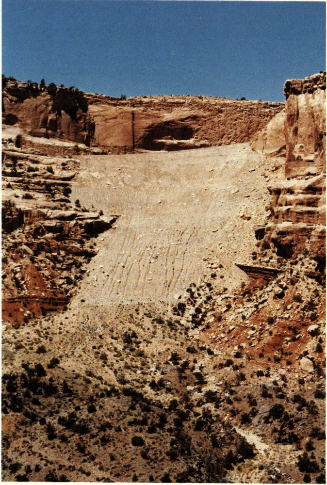
NEW FILL ON RIM ROCK DRIVE BETWEEN TWO TUNNELS ON WEST SIDE OF FRUITA CANYON, looking west from east side of canyon. Previous fill was washed out by flash flood, as described in text. (Fig. 44)
99
The road remained closed for 1½ years until December 20, 1969, much to the annoyance and discomfort of both visitors and Monument personnel—particularly the latter. During the summer, the usual 16-mile daily round trip to the post office in Fruita via the West Entrance was increased to about 80 miles by way of the East Entrance. During the school season, wives of Monument personnel took turns driving a station wagon full of children on two daily round trips to the schools and post office in Fruita. Note in figure 44, taken only 6½ years after the road was reopened, that small gullies already have been cut in the lower half of the new fill. Another local cloudburst could remove the new fill, but let us hope this does not happen!
On the next curve to the east the road cuts entirely through the red Chinle Formation, which here has a measured thickness of 103 feet.[37] From the base of the Chinle to about the creek crossing the road cuts expose the old Proterozoic metamorphic rocks, which here have a purple hue.
BALANCED ROCK
11
At the southernmost loop of the road is a parking area for viewing Balanced Rock. The photograph for the frontispiece was taken from the hillside near the foot of the monolith.
HISTORIC TRAILS VIEW
12
After the road turns north, we again cross the entire Chinle Formation, then penetrate the Wingate Sandstone through the two tunnels (turn on your lights) shown on all the maps and in figures 33 and 44. Just beyond the highest tunnel (turn off your lights) we reach Historic Trails View, with a sign noting the early expeditions that traversed the area. West from the parking area, but better yet by walking to the westernmost curve, may be seen the northern part of the Black Ridge Trail.
100
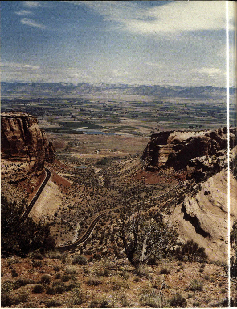
FRUITA CANYON, looking northeast from point on Rim Rock Drive above head of canyon. Dark Proterozoic rocks floor the canyon, above which are the slopes of the red Chinle Formation and the cliffs of Wingate Sandstone capped by the lower resistant beds of the Kayenta Formation. Beyond the Grand Valley are the dark Book Cliffs and the more distant, light-colored Roan Cliffs, which are shown more clearly in figure 48. (Fig. 45)
101
FRUITA CANYON VIEW
13
This foot trail is part of the old stock trail over which sheep and cattle once were driven down to the Grand Valley from Glade Park and Piñon Mesa. The road then winds upward through a series of switchbacks cut into the Kayenta Formation to Distant View and then to a parking spot at the relatively new Fruita Canyon View, which affords a splendid view of Fruita Canyon. Figure 45 was taken from a point about a tenth of a mile to the east. On the right are housing facilities for Monument personnel.
CAMPGROUND AND PICNIC AREA
14
At the top of the hill just beyond the head of Fruita Canyon, two roads turn left; the first makes several loops through the modern campground and picnic area then returns to Rim Rock Drive; the second enters a large parking lot at the Visitor Center. Let us take the first road, then turn sharp to the left again just west of the Saddlehorn and explore the camp and picnic areas, which are on a gently sloping mesa of the Kayenta Formation dotted with piñon and juniper trees and bushes of many kinds. The Saddlehorn is an erosional remnant of the Entrada Sandstone. (See fig. 50.) The deluxe campground has both drive-through and back-in campsites, modern restrooms, tables, piped water, and grills. Two of the drive-through sites on the northernmost loop are shown in figure 46.
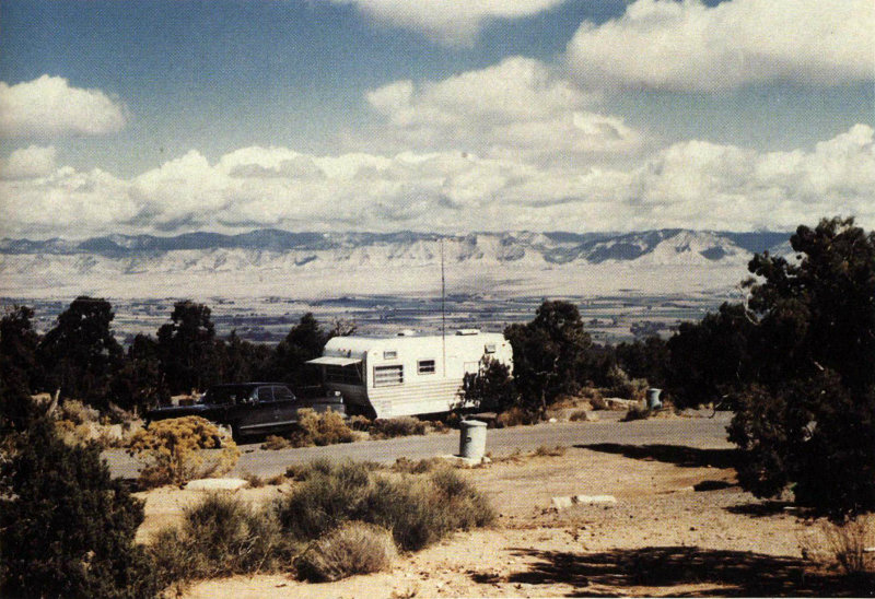
CAMPSITES AT NORTH END OF CAMPGROUND, Grand Valley and Book Cliffs beyond. (Fig. 46)
102
A view of the picnic area and parking lot is shown in figure 47. During the summer, evening slide talks are given by rangers at a small amphitheater just north of the Saddlehorn and to the left of the view shown in figure 47.
WINDOW ROCK
An interesting quarter-of-a-mile self-guiding Window Rock Nature Trail leads from the northeast corner of the campground to Window Rock and loops back past Book Cliffs View, which contains a table beneath a ramada. Window Rock Trail connects with the scenic Canyon Rim Trail, which leads southwestward to the Visitor Center. Views of Window Rock and Monument Canyon from Canyon Rim Trail are shown in figures 48 and 49.
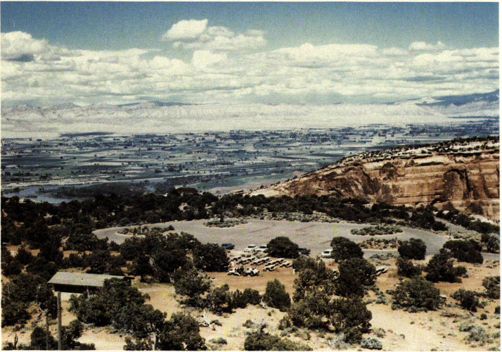
PICNIC AREA AND PARKING LOT, looking northeast from top of the Saddlehorn. Large groups can be accommodated by making advance reservations. Cliff of Wingate Sandstone on right across Monument Canyon is part of Lizard Canyon monocline. (See fig. 29.) (Fig. 47)
VISITOR CENTER—MONUMENT HEADQUARTERS
After we return to Rim Rock Drive, a double left turn brings us to a large parking lot. We are now at the Visitor Center and Monument Headquarters, which is well worth a visit. In the front of the building are modern restrooms and a drinking fountain. Inside the lobby may be purchased film, slides, post cards, maps, booklets, and reports. A narrated slide show and museum help materially in conveying just what the Monument has to offer. I was pleased at being asked to contribute several of the geologic exhibits, partly with the aid of former Survey artist John R. Stacy. From the back door a path leads to a fenced overlook for viewing an arm of Monument Canyon. The overlook also is the beginning of Canyon Rim Trail which connects about half a mile to the northeast with Window Rock Trail at Book Cliff View.
103
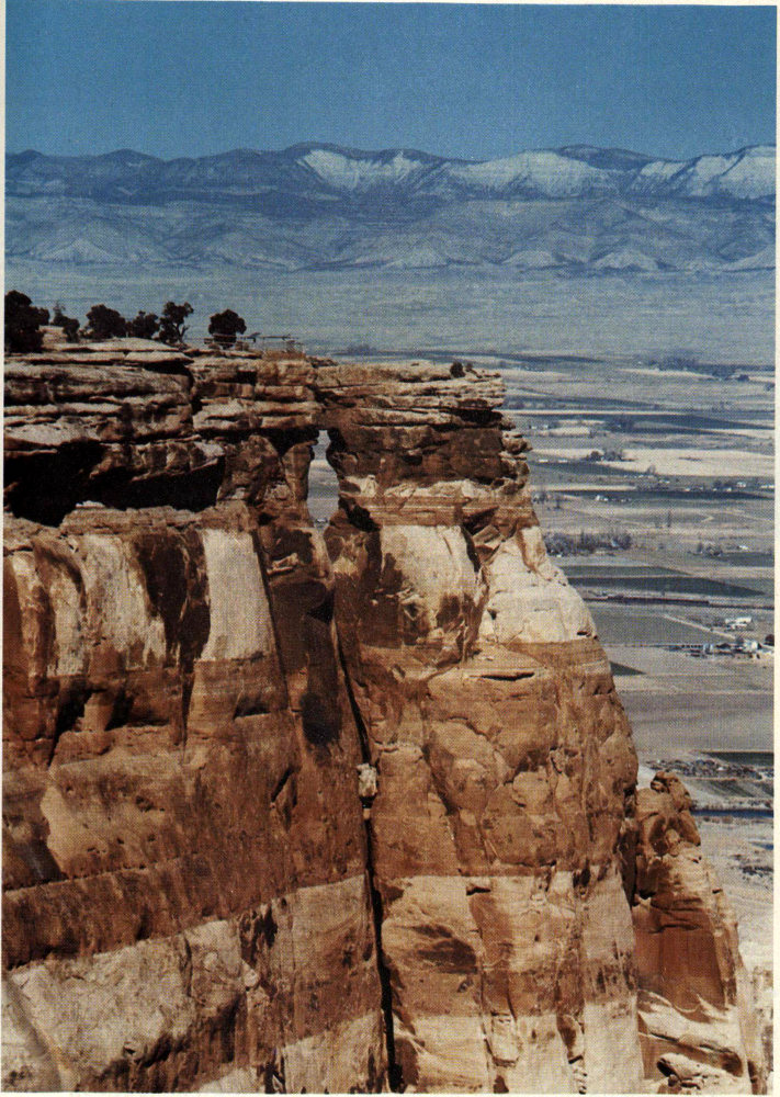
WINDOW ROCK, a window eroded along a vertical joint near the top of the Wingate Sandstone. Telephoto view looking northeast from Canyon Rim Trail. Note fenced overlook on Kayenta Formation to left of window to keep people from crossing joint above window, for someday the monolith to the right will fall, as did Fallen Rock (fig. 35). Note light-colored Roan Cliffs of Green River Formation beyond Book Cliffs. (Fig. 48)
104
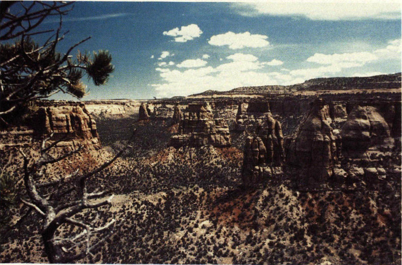
PIPE ORGAN, looking southeast across Monument Canyon from Canyon Rim Trail, and Independence Monument to left beyond. Photograph by Darrell Arnold, Grand Junction. (Fig. 49)
GAP IN ROCK RECORD
15
Half a mile southwest of the parking lot is one of the narrowest stretches of Rim Rock Drive at the edge of a Wingate cliff that actually overhangs. But do not worry, it is well protected by a rock wall. At the head of the canyon is a large jumbled landslide of the Morrison Formation that has covered the cliff of Entrada Sandstone. Along the narrow stretch and just beyond the landslide are excellent views on the right of the erosional unconformity between the eroded surface of the Kayenta Formation and the overlying Slick Rock Member of the Entrada Sandstone, a view of which is shown in figure 15 and a discussion of which is given on pages 35 to 39.
PIPE ORGAN
16
From the next parking area to the northeast at Pipe Organ Overlook we may hike half a mile over Otto’s Trail to an overlook of the Pipe Organ; a view of the Pipe Organ from the 105 northwest is shown in figure 49. From about the middle of this trail we may look to the northwest across the canyon to the Visitor Center and the Saddlehorn (fig. 50).
DEPENDENCE VIEW
17
At the next parking area at Independence View we see Independence Monument (fig. 51) from quite a different angle than the photograph shown in figure 6. This view clearly shows it to be a thin erosional remnant of a narrow wall that once connected mesas to the northeast and southwest and which separated the two entrances of Monument Canyon.
GRAND VIEW
18
Grand View, six-tenths of a mile farther southeast, affords excellent views of several features in and near Monument Canyon. A short improved trail to the northeast leads to a sandstone ledge from which the infrared photograph for the front cover was taken. The trail then veers eastward to a fenced cliff-top viewpoint from which one may look nearly straight down to a stretch of Monument Canyon Trail. You may see hikers on the trail or buffalo in the canyon. The photograph for figure 6 was taken from a point just north of the north end of the parking area.
MONUMENT CANYON VIEW
19
Another 1⅓ miles takes us to the next parking area at Monument Canyon View, from which one may walk a short distance to the northeast. The photograph shown in figure 13 was taken from a point northeast of the parking area.
From the head of Fruita Canyon to Monument Canyon View, Rim Rock Drive is on a bench of the Kayenta Formation that separates the two lines of cliffs. We must now leave this bench, however, because from near Coke Ovens Overlook to beyond Artists Point the bench ceases to exist, and the Entrada, Kayenta, and Wingate form virtually a single cliff. Moreover, we must get up into the Morrison Formation in order to cross the divide between Monument and Ute Canyons. For these reasons, in the next three-quarters of a mile south of Monument Canyon View the road cuts upward through the entire Entrada Sandstone. Just beyond the first curve are quarries on the right from which curb and building stones were cut by the Civilian Conservation Corps in the 1930’s for protecting overlooks and narrow stretches of road. At the southwest end of this stretch is another parking area at Coke Ovens Overlook, which provides good views of the north side of the Coke Ovens.
COKE OVENS OVERLOOK
20
The next parking area a quarter of a mile to the southwest is the Monument Canyon Trailhead of the long trail to the mouth of Monument Canyon and of a short trail to the Coke Ovens.
ARTISTS POINT
21
Half a mile to the southeast takes us to a large parking area at Artists Point, which offers a wide variety of scenic views. The best exposure of the Summerville Formation in the entire area that I mapped[38] is on the west side of the road, as shown in figure 20. A short trail leads down to a fenced overlook for viewing the Coke Ovens to the north (fig. 11) and Monument Canyon to the northeast.
106
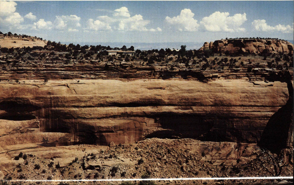
VISITOR CENTER AND THE SADDLEHORN, looking northwest across canyon from Otto’s Trail. Note thin-bedded bench of the Kayenta Formation separating cliffs of the Entrada Sandstone above the Wingate Sandstone below. The Saddlehorn is the remnant of the Entrada at the extreme right. (Fig. 50)
107
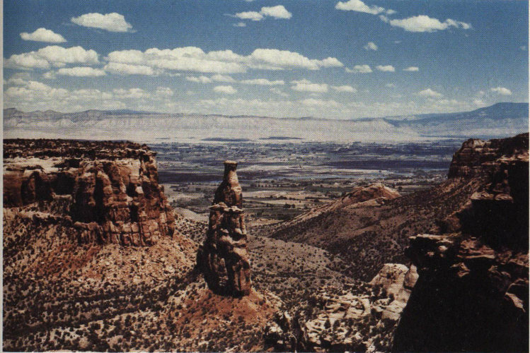
INDEPENDENCE MONUMENT, looking northeast from Independence View. Note updragged block of Wingate Sandstone at northwestern end of Redlands fault, just to the right of center. The other side of this block is shown in figure 41. Grand Mesa forms right skyline. (Fig. 51)
HIGHLAND VIEW
DIVIDE
22
The Summerville Formation is exposed on the right for about the next half a mile. In the next three-quarters of a mile to Highland View the roadcuts are in the sandstone ledges of the Salt Wash Member of the Morrison Formation. Another half a mile through massive Salt Wash sandstones takes us to the second highest point on Rim Rock Drive—the divide between Monument and Ute Canyons, altitude 6,593 feet. From here we may look far to the south across Glade Park to high Piñon Mesa—the highest part of the Uncompahgre Plateau 108 northwest of Unaweep Canyon, where the altitude is about 9,500 feet.
LIBERTY CAP TRAILHEAD
23
Halfway down the hill to the south is a parking area on the left at the head of Liberty Cap Trail, which goes eastward about 6 miles to Liberty Cap—a prominent conical point atop the Wingate cliff just west of the mouth of Ute Canyon, which appears on the left skyline of figure 38. From there, the trail descends about 2 miles to a gate in the boundary fence at the mouth of Ute Canyon. The roads connecting the gate with South Camp Road (fig. 3) were reported (1979) to be closed to foot travel by private landowners, so hikers reaching this point must either retrace their steps to the parking area at the head of the Liberty Cap trail, or return by a primitive trail up main Ute Canyon, turn right up the west arm of the canyon, and regain Rim Rock Drive by a short switchback trail noted on page 109. However, the Park Service hopes that in the future some sort of corridor can be established to connect the trailhead with the nearby roads. Most of the “trail” up Ute Canyon is the normally dry channel of the creek, so hikers should watch out for flash floods. The round trip by Liberty Cap Trail alone is about 16 miles, and if the return trip is made by Ute Canyon the total distance is about 13 miles. Accordingly, hikers should allow a full day and carry food and water.
GLADE PARK ROAD
A quarter of a mile west of the Liberty Cap parking area in the west arm of Ute Canyon is a junction with a gravel road that leads 5 miles south to the Glade Park General Store and Post Office, where groceries, beer, gasoline, and fishing and camping supplies are available. Glade Park connects with scenic roads leading east, west, and south. Later, we will cover in more detail a round trip from the intersection in Ute Canyon to one near Cold Shivers Point, and another round trip from Glade Park around the head of No Thoroughfare Canyon and back to Grand Junction via the Little Park Road.
But to continue with the trip through the Monument—from the intersection with the gravel road to Glade Park, Rim Rock Drive turns abruptly to the southeast and follows the west arm of Ute Canyon for some 3 or 4 miles, past many interesting points. For the next 1⅓ miles to the first culvert, which crosses a large tributary, the roadcuts are in the Summerville Formation and Entrada Sandstone. The photographs in figures 16 and 17 were taken looking north from the culvert and from just northwest of the culvert, respectively.
FLOOD
24
One day when my family and I were approaching the culvert from the west, we heard a roar like an express train. Looking to the south we saw that a severe thundershower was occurring 109 on the headwaters in Glade Park, so we raced ahead and parked east of the culvert just in time to see and hear a 4-foot wall of red water come roaring down the tributary, rolling boulders along as if they were basketballs. Unfortunately, we had no time to ready or use a camera, so we simply raced down the road embankment and through the trees and brush to the north in time to see the flood plunge eastward over a 350-foot cliff of the Wingate Sandstone to the canyon below. This illustrates the need for caution when following or crossing “dry” washes in the desert in stormy weather or when there are storms in the distance.
UPPER UTE CANYON VIEW
25
About two-tenths of a mile northeast of the culvert is Upper Ute Canyon View, which affords good views of the northeast cliff face of the west arm of Ute Canyon.
FALLEN ROCK OVERLOOK
UTE CANYON TRAILHEAD
26
For the next 7½ miles Rim Rock Drive is once again on a bench of the Kayenta Formation between cliffs of the Entrada and Wingate Sandstones. From Upper Ute Canyon View the road goes southeastward along the canyon rim about three-tenths of a mile to a parking area. A short trail leads down from the parking area to fenced Fallen Rock Overlook; the view shown in figure 35 is from this point. As noted in the caption of figure 35, and on page 108, the Ute Canyon Trail zigzags down the slope from the road a quarter of a mile southeast of the parking area, but there is no parking area at the trailhead, so it is safer to park at Fallen Rock Overlook and walk to the trailhead. The connection with this trail and the Liberty Cap Trail also is discussed on page 108. On one hike down this trail we saw two elk, which is a rare sight at such a low altitude, for they generally stay on or near Piñon Mesa.
UTE CANYON
27
About a mile to the southeast, just beyond the steep dropoff on the left, there is room to park, walk a short distance through the trees to the east, and observe a fine view of main Ute Canyon, as shown in figure 52. Just beyond on our right are the cliffs of the mottled salmon-and-white Slick Rock Member overlain by the all white Moab Member, as shown in figure 18 and described in the accompanying text.
Half a mile southeast, where the road makes a gentle U-turn and continues northeastward, we reach the highest point on Rim Rock Drive at an altitude of about 6,640 feet. Note that the piñon and juniper are larger, and the bushes are larger and greener at this altitude, for the average precipitation increases as we go higher.
LOWER UTE CANYON VIEW
28
About a mile northeast of the highest point on the road is a large parking area on the left, from which a short, shaded trail leads to a fenced overlook called Lower Ute Canyon View, which faces the northwest arm of Ute Canyon across the main canyon.
110
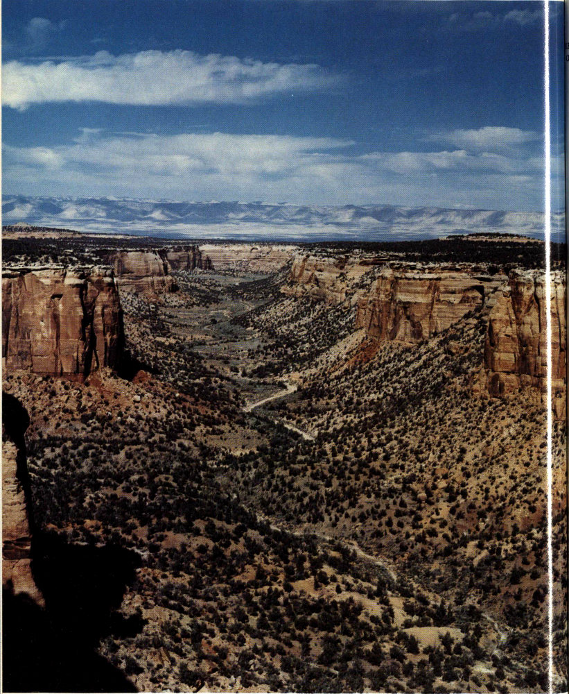
UTE CANYON, looking northeast from point described in text. Note grass-covered alluvium in distant part of canyon floor. (Fig. 52)
111
RED CANYON OVERLOOK
29
About half a mile beyond this parking area, we reach a small parking area at Red Canyon Overlook, from which the photograph shown in figure 12 was taken. The dark green bush of Mormon Tea in the right foreground of figure 12 is one of the largest I have seen in the Monument. The reasons for the differences between the left and right walls of the canyon are discussed on pages 79 and 80. The ripple-marked curbstones of white sandstone in the parking area were quarried from the Moab Member of the Entrada Sandstone northwest of Fruita Canyon, as noted on page 96.
DS ROAD
COLD SHIVERS POINT
30
Another 2½ miles around the south rim of Red Canyon and the head of Columbus Canyon takes us to the junction with the paved county road known as the DS Road, which leads south and southwest to Glade Park and to the head of No Thoroughfare Canyon. This important intersection will be included in trips through Glade Park and around the head of No Thoroughfare Canyon, so it will be discussed later. Meanwhile, we will continue our trip eastward from this intersection. About a third of a mile to the northeast is a large parking area, with a path leading to a fenced overlook at the rim of Columbus Canyon for viewing Cold Shivers Point—perhaps the most aptly titled feature in the Monument (fig. 53). A primitive path leads from the overlook to the toadstool-shaped platform at upper right, on which some visitors dare to stand, but not me. When the old, steep Serpents Trail was the only route for autos to ascend from the East Entrance, barrels of water were kept at this parking area to quench the thirst of boiling radiators.
HEAD OF SERPENTS TRAIL
31
After leaving the parking area, the downgrade on the Kayenta Formation begins to steepen to the northeast until it becomes advisable to shift into second gear. In about half a mile we descend a series of steep switchbacks cut into the Wingate Sandstone on the steepening Ladder Creek monocline (figs. 8, 29), and we reach the present upper end of the old Serpents Trail (fig. 54), which is now an interesting foot trail. As noted earlier, it is convenient to hike down this steep 2½-mile trail and to have one member of the party drive ahead and await the hikers at the parking area in the Devils Kitchen Picnic Area, near the foot of the trail. One of many rewarding views seen during the hike is shown in figure 55, another was seen in figure 10.
112
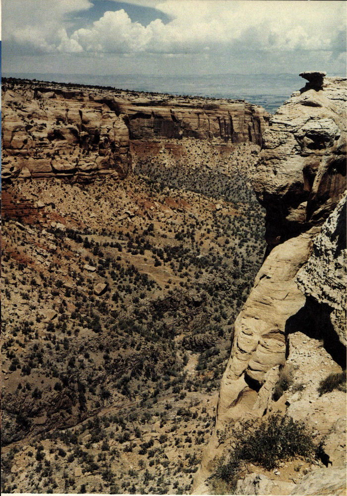
COLD SHIVERS POINT, looking north from fenced overlook on east edge of Columbus Canyon. Named feature is toadstool-shaped rock at upper right. Note dark Proterozoic rocks in canyon bottom. (Fig. 53)
113
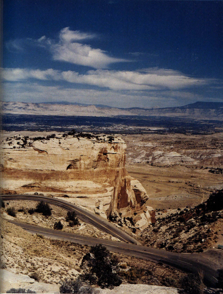
TOP OF OLD SERPENTS TRAIL, looking northeast from switchbacks above tunnel. Top of trail is seen at sign on lower right. Grand Mesa forms right skyline. (Fig. 54)
114
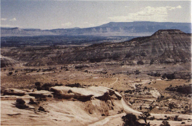
LOOKING NORTHEAST FROM OLD SERPENTS TRAIL, before 1950 when the trail was still used by autos and trucks. One of John Otto’s old foot trails joins the old road at lower middle. Although no thick lenses of sandstone appear in the Salt Wash Member of the Morrison Formation in figure 21, in this view a lens about 50 feet thick begins just around the corner near the base of the high bluff across No Thoroughfare Canyon and is seen extending as far to the left as the normally dry wash that drains the canyon. When water flows down the wash after thundershowers (see p. 118) or from melting snow, the sandstone lens takes in water (recharge) which moves slowly down the dip of the lens to the northeast and supplies several artesian wells. In turn, the light band of the Entrada Sandstone beneath the cottonwood trees at the right middle and the dark patch of Wingate Sandstone at the extreme lower right are recharged in like manner, and they supply water to artesian wells to the northeast. As the older and deeper sandstones on the right take in water at higher altitudes, the water in them is under greater artesian head when tapped by wells. If you think you see covered wagons near the middle of the photograph arranged in a circle for defense against attack by Indians, you are correct—a Western movie was about to be filmed. (Fig. 55)
115
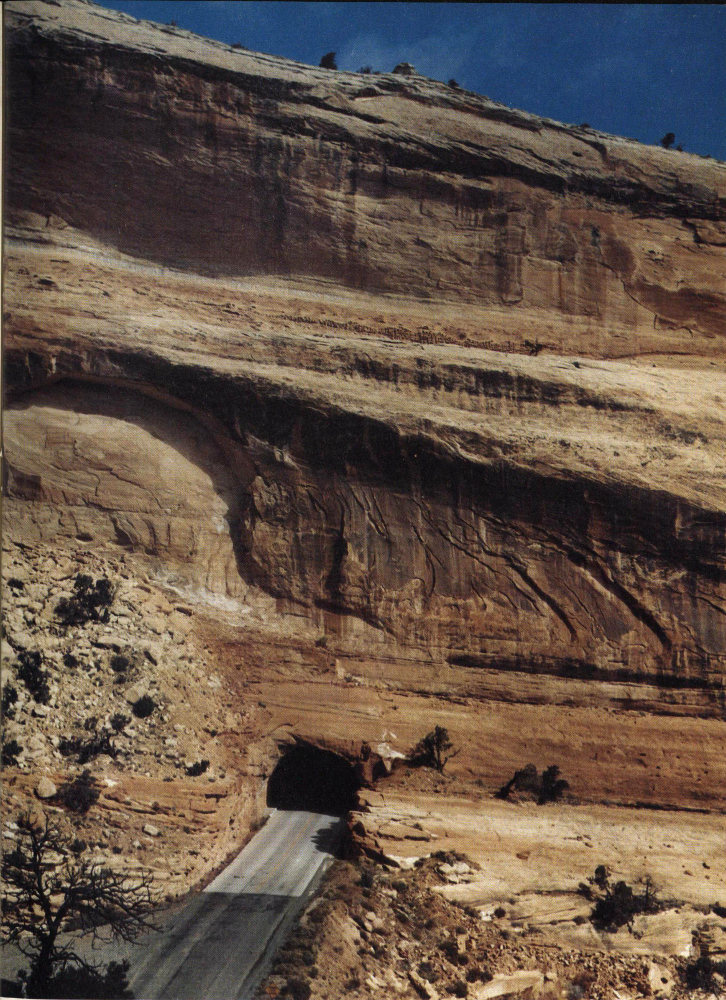
SOUTH PORTAL OF TUNNEL THROUGH WINGATE SANDSTONE, on west side of No Thoroughfare Canyon above East Entrance. (Fig. 56)
116
FOOT OF SERPENTS TRAIL
Just beyond the lowest switchback shown in figure 54, we penetrate the Wingate Sandstone through a tunnel, the south portal of which is shown in figure 56. After we drive through a deep cut in the Wingate Sandstone just south of the tunnel, we cross the entire red Chinle Formation, then descend a series of switchbacks in old Proterozoic rocks. The Chinle Formation is crossed again near the foot of the hill, where it is about 80 feet thick,[39] then we recross the Wingate Sandstone and Kayenta Formation to the parking area in the Devils Kitchen Picnic Area, near the foot of the old Serpents Trail.
DEVILS KITCHEN
32
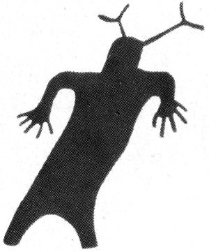
An improved marked trail leads southward from parking area at the foot of the Serpents Trail, crosses No Thoroughfare Canyon, and continues as an unimproved trail to the Devils Kitchen, a view of which is shown in figure 57. The petroglyphs shown in figure 4 are northeast of this parking area. Those interested in seeing them should inquire at the ranger station or checking station at the East Entrance.
EAST ENTRANCE
Just beyond the parking area, near the foot of the old Serpents Trail, a road turns left to a larger parking area for the Devils Kitchen Picnic Area, where covered tables, grills, and water are available. Just beyond we pass the checking station and housing facilities for Monument personnel at the East Entrance of the Monument. During the summer, fees are collected at this checking station from persons entering the Monument. A well just east of the housing area obtains water from the Entrada Sandstone to supply the houses and picnic area.
117
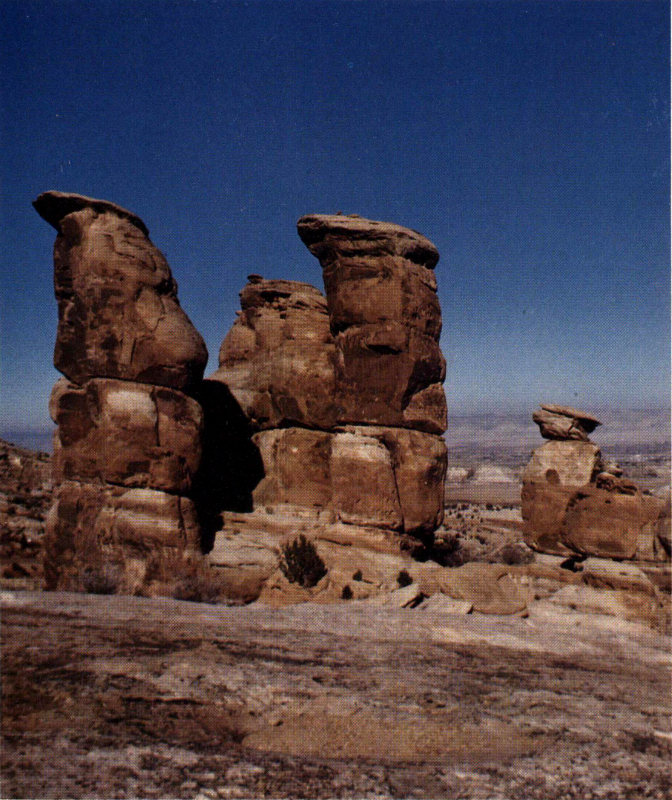
DEVILS KITCHEN, looking north from ridge in middle of No Thoroughfare Canyon. An erosional remnant of the Wingate Sandstone capped by the lowermost sandstone of the Kayenta Formation. Photograph by T. F. Giles, U.S. Geological Survey. (Fig. 57)
118
From the East Entrance to Grand Junction
SOUTH CAMP ROAD SHORTCUT
Three fourths of a mile beyond the checking station, South Camp Road turns left and joins South Broadway 2½ miles to the northwest. This provides a fine shortcut for persons desirous of travelling back northwestward through The Redlands to regain the West Entrance of the Monument. The intersection of South Camp Road and South Broadway, a key point on the trip “From Grand Junction through The Redlands to the West Entrance of the Monument,” is noted on page 89.
But let us continue our 3-mile return trip to Grand Junction, in order to point out several things of interest along Monument Road in the lower part of No Thoroughfare Canyon. As the canyon narrows just beyond the road intersection, we see on both sides colorful badlands of the Morrison Formation capped by the rusty looking basal sandstones of the Burro Canyon Formation. Behind the building on the right just before the road curves to the left is an artesian well 575 feet deep that taps both the Entrada Sandstone and a sandstone lens in the Morrison Formation[40].
GAP IN ROCK RECORD
33
About 2½ miles below the checking station, we pass on the left the basal sandstone of the Burro Canyon Formation resting on the Morrison Formation, as shown in the lower left of figure 24. Just beyond we may look up the hill to the left and see the 40-foot basal conglomerate of the Dakota Sandstone resting unconformably on an old erosion surface atop the Burro Canyon Formation.
FLOOD DAMAGE
Just before we reach the T-intersection with the eastern segment of South Broadway we may still see on the right some of the destruction caused by a devastating flood that roared down No Thoroughfare and other canyons on September 7, 1978, as a result of what was termed the worst cloudburst to hit Glade Park, the Monument, and the Grand Valley since 1958. A house on the flood plain just above the bridge was badly damaged and was filled with 4 feet of mud, and the Monument Road bridge across No Thoroughfare Canyon nearest the intersection was washed out, necessitating the rerouting of traffic to and from the East Entrance of the 119 Monument. Moral—never build a house or even pitch a tent in a dry wash or arroyo in desert regions! Incidentally, indirect measurements by engineers of the U.S. Geological Survey indicated a discharge of 9,290 cfs just above the washed out bridge in No Thoroughfare Canyon, and 2,980 cfs in Red Canyon beneath the Broadway bridge.
SOUTH BROADWAY
Inasmuch as the bridge on Monument Road has long since been rebuilt, we will cross it, turn right on South Broadway at the T-intersection, cross the Redlands Power Canal (p. 88), and join Colorado Highway 340 at the traffic light; thus, we complete a round trip “From Grand Junction through The Redlands to the West Entrance of the Monument,” “Through the Monument from West to East Entrances,” and “From the East Entrance to Grand Junction.”
Through Glade Park from the Northwest Arm of Ute Canyon to Columbus Canyon
GLADE PARK ROAD
34
A very pleasant 11-mile drive through Glade Park may be made from the intersection where Rim Rock Drive crosses the northwest arm of Ute Canyon (p. 108) to the intersection with the same drive on the rim of Columbus Canyon a quarter of a mile southwest of Cold Shivers Point (p. 120). The name Glade Park refers not only to the Store and Post Office mentioned earlier, but also to a nearly flat farming and ranching area south of the Monument—an area entirely different from the Monument or The Redlands. Most of the cultivated part of Glade Park is underlain by nearly flat lying Entrada Sandstone which was weathered to a sandy soil, but a few areas are underlain by the Morrison Formation. This drive should appeal particularly to people spending from a few days to a week or more in the campground. For the more adventuresome, other interesting roads join Glade Park from several directions, as noted below.
After leaving Rim Rock Drive at Ute Canyon, on a good 120 gravelled road, we traverse attractive, hilly, wooded country generally southward for about a mile and climb some 300 feet to a flat area covered mainly by sagebrush and grass. About 3 miles south of the intersection, we see on the left the leached white outcrops of the Entrada Sandstone shown in figure 19.
GLADE PARK
35
Another 2 miles takes us to the Glade Park Store and Post Office at a four-way intersection.
An improved, gravelled road leads westward through pleasant country some 20 miles to the Utah State line, beyond which an unimproved road leads either to the Colorado or the Dolores Rivers. Future planning calls for improving the Utah stretch of this road and for building a bridge across either the Colorado or Dolores Rivers to connect with scenic Utah Highway 128. If and when completed, this would afford a very scenic shortcut from Moab, Utah, to Grand Junction via the Little Park Road (to be described).
South from the four-way intersection an improved gravelled road takes us through wooded country, past lakes and campgrounds, to the summit of Piñon Mesa, as noted earlier.
GLADE PARK FAULT
36
Also, from the intersection a paved county road known as DS (south) Road leads eastward then northeastward through farming and ranching country 6 miles to the intersection with Rim Rock Drive near Cold Shivers Point. Three-fourths of a mile east of the Glade Park Store and Post Office the road crosses the Glade Park fault (fig. 8) along which the Morrison and Summerville Formations on the right have dropped down with respect to the Entrada Sandstone on the left. Here, the Entrada also has been leached to white.
LITTLE PARK ROAD
37
At 1½ miles east of the Glade Park Store and Post Office is the intersection with the improved gravelled Little Park Road, which will be described later. At 2¾ miles beyond this intersection, the DS Road leaves the Entrada Sandstone and is on a wooded stretch of the Kayenta Formation the remaining 2 miles to Rim Rock Drive. The last one-tenth of a mile is crooked and steep, so please slow down before reaching the stop sign at the intersection. Some years ago the brakes on a pickup truck failed as the driver approached the stop sign, but he was lucky enough to jump out at the top of the cliff just before the truck plunged to the bottom of Columbus Canyon.
121
From Glade Park to Grand Junction Via the Little Park Road

GLADE PARK FAULT
38
From the intersection 1½ miles east of the Glade Park Store and Post Office, let us turn southeast on the recently improved and gravelled Little Park Road around the head of No Thoroughfare Canyon, which was added to the Monument in 1978 (fig. 3). From the intersection it is about 14 miles to Grand Junction by this route. In half a mile we reach the new boundary of the Monument at a minor drainage divide, and as we start down a steep hill beyond we may park on the right and look southeastward across No Thoroughfare Canyon along the Glade Park fault (fig. 58) which has produced the fishtail shape of the head of the canyon, as shown in figures 8 and 59. A different view of the fault and canyon head is shown by the stereoscopic pair of aerial photographs in figure 59.
The Little Park Road closely follows the new Monument boundary around the south end of No Thoroughfare Canyon, either on the Kayenta Formation or Entrada Sandstone, and affords good views into the canyon from several places. East of the southeast arm of the canyon, the road leaves the boundary and goes northeastward about 4 miles to the end of the improved part of the road, but the unimproved part is good, and the lower 5 miles is paved. On my geologic maps[41] of the area, I called this road by its older name—the Jacobs Ladder Road.
LADDER AND ROUGH CANYONS
39
About a quarter of a mile from the end of the improved stretch, one may turn right on two tire tracks, travel about a quarter of a mile farther, and park near the junction of Rough and Ladder Canyons, where interesting geology is reachable by short walks up Ladder Canyon or down Rough Canyon. 122 About a mile up Ladder Canyon is an interesting abandoned mica mine.[42]
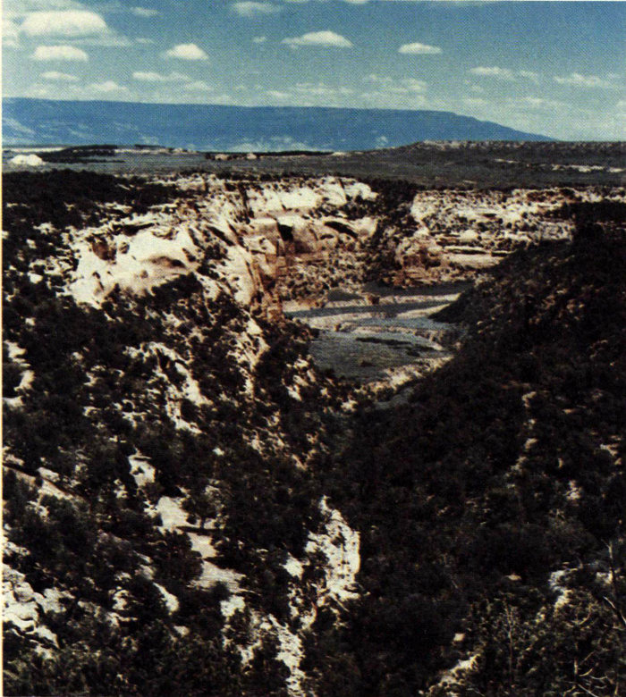
GLADE PARK FAULT VIEWED FROM THE GROUND, crossing head of No Thoroughfare Canyon. Looking southeast from Little Park Road just southeast of new Monument boundary. Fault passes just to right of white cliff of Wingate Sandstone near bottom of photograph through notch in east wall of canyon. Note that surface to right (south) of fault has dropped about 50 feet below left side. Grand Mesa forms skyline. (Fig. 58)
From the left side of the road, about 9 miles northeast of our starting point, we see the view shown in figure 60. About 2 miles farther north, Little Park Road is paved through a suburban housing development all the way to The Redlands; there, we may turn right, cross the Gunnison River, and reach U.S. Highway 50; or we may turn left through Rosevale and reach Colorado Highway 340.
123
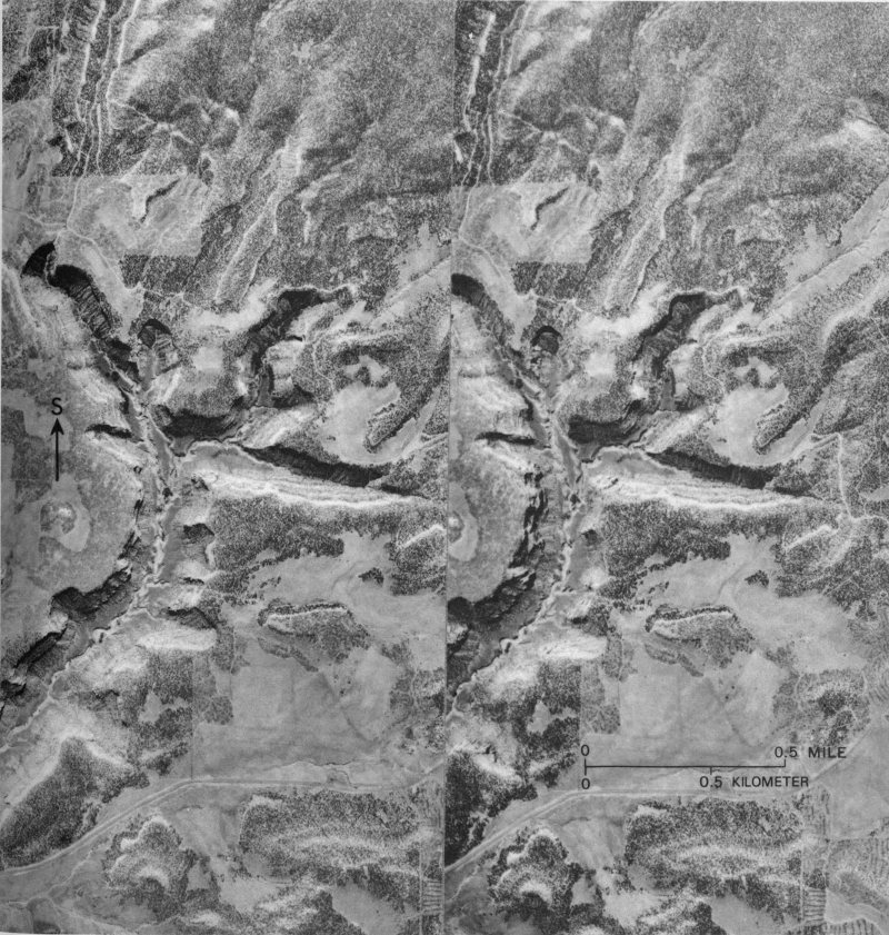
GLADE PARK FAULT VIEWED FROM THE AIR, crossing head of No Thoroughfare Canyon from left to right. Land south of the fault was dropped some 50 feet below that on the north side. Primitive road around head of canyon has been improved and realined since photographs were taken. The stereoscopic pair of aerial photographs may be viewed without optical aids by those accustomed to this procedure or by use of a simple double lens stereoscope, such as the folding ones used by the armed forces during and after World War II. Compare with the geologic map, figure 8. Photographs taken in 1937 by U.S. Soil Conservation Service. (Fig. 59)
124
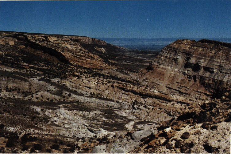
LADDER CREEK MONOCLINE AND REDLANDS FAULT, looking northwest from lookout point near Little Park Road. Telephoto view of left half of this scene is shown in figure 29; photograph of Morrison Formation shown in figure 21 was taken from point about a mile farther north. (Fig. 60)
125