Chapter XVII · THE PROGRESS OF ENCLOSURE WITHOUT PARLIAMENTARY SANCTION.
Reading edition
A. FROM 1845 ONWARDS.
Any statistical account of enclosure without Parliamentary sanction must necessarily be vague in comparison with the statements which it is possible to make of enclosure by Act of Parliament, and must consist of inferences from evidence of varying value. And, naturally, the evidence in general becomes scantier in proportion as the period investigated is more remote.
The Tithe Commutation maps and awards afford the richest mine of information for the period since 1836. We have seen that according to the analysis of them published by the Copyhold, Enclosure and Tithe Commission in 1873, they indicated the existence at that date of 264,307 acres of common fields. We have already seen how untrustworthy this estimate is if taken for a basis for calculating the area of existing common fields, how inaccurate it was even at the date at which it was published. But one great source of inaccuracy in it, as we have seen, is the assumption that no enclosure, other than by Act of Parliament, took place after the date of Tithe Commutation. If we could eliminate all other errors, and also get a perfectly accurate statement of the area of existing common fields, we should then know how much enclosure of common fields has taken place without Parliamentary intervention since the date of Tithe Commutation. This date, of course, is different in different parishes, but the average date is about 1845.
To eliminate all other errors it would be necessary to go over all the work again, a task which would take a single investigator several years of continual labour, and would not then be accomplished unless the investigator were himself infallible. We must therefore be content with an approximate correction.[92]
The tithe maps and awards deposited with the Tithe Commission cover about three-quarters of the area of England and Wales. The amount of common field in the other quarter is estimated on the assumption that in each county the part for which there are no tithe awards in the custody of the Tithe Commission contained the same proportion of common field as the part for which title awards existed. The common fields thus estimated amount to about two-fifths of the total estimate. If the particulars given in the return for the different counties were added up, we should get the statement:—
Common Field Lands. Acres.
Areas ascertained from the tithe documents 163,823
Estimated additional areas 100,484
264,307
We have seen that assuming the total of 163,823 acres is correctly “ascertained,” the estimate of 100,484 acres for the other parishes is very excessive, because the most frequent reason for no title documents existing in the custody of the Tithe Commission is that the commutation of tithes was effected before 1836 by a local Enclosure Act, which swept away the common fields.
In consequence, counties which were mainly enclosed by Acts of Parliament are very partially covered by the tithe documents; counties which have few or no Acts for enclosure of common fields are nearly entirely so covered. For example, we have—
— Percentage of Area enclosed by Acts. Area Covered by Tithe Documents. Area not so Covered.
Counties of Parliamentary Enclosure.
Northampton 51·5 148,066 485,220
Rutland 46·5 37,728 54,968
Huntingdon 46·5 83,856 146,630
Bedford 46·0 104,357 191,159
Oxford 45·6 214,889 252,417
East Riding, Yorkshire 40·1 263,473 479,228
Leicester 38·2 158,889 352,539
Counties with little or no Parliamentary Enclosure.
Devon Nil. 1,611,710 46,039
Cornwall Nil. 851,486 6,122
Kent Nil. 973,726 29,246
Shropshire 0·3 788,108 64,385
Monmouth 0·4 329,430 16,292
Cheshire 0·5 599,904 115,931
Fortunately there is another possible way of calculating the probable area of common field land which would have been found in the parishes not covered by tithe documents, if it had been investigated at about the same date.
Out of the seventy-five parishes enclosed by Act of Parliament since 1850—i.e., at a later date than almost all of the tithe documents—the Tithe Commission had the maps and awards of seventy-one—all, that is, but four. Common fields subsequently enclosed were to be found in these two classes of parishes in the proportion of 71 to 4; it is a fair inference that the total area of common fields, whether subsequently enclosed or not, was distributed in the same proportion.
On this assumption we should have the following calculation:—
Common Field Lands. Acres.
Areas ascertained from the tithe documents 163,823
Estimated additional areas 9,229
Total 173,052
No probable error in the additional estimate in this calculation would have an appreciable effect on the total.
Next, as we have noticed above, the “areas ascertained” require correction. This it is much more difficult to supply satisfactorily; all that we can do is to determine—(1) whether the number given is likely to err by excess or by defect; (2) whether the error is likely to be large.
The main purpose of the return was to establish the total amount of waste land subject to common rights, and the proportion of such land likely to be capable of cultivation. This part of the work was done with great care, and particularly with great care not to include any land which was not certainly subject to common rights. The final figure arrived at was certainly considerably in defect through the documents on which it was based failing to mention common rights in all cases where they existed.
The part of the return relating to common field lands, on the other hand, was considered of less importance; the explanatory letter says with regard to them:—
“The common field lands are generally distinguishable by the particular manner in which they are marked on the tithe maps, and their extent has been estimated by these maps.” This means that areas on the tithe maps subdivided by dotted lines were assumed to be common field lands. This method had the advantage of comprehensiveness—it is probable that scarcely any common field land escaped notice, if there were a tithe map for the parish in which it existed. I have only detected one error of omission. The common fields of Eakring were very considerably in excess of the 54 acres at which they were estimated. But on the other hand it has the disadvantage of including with common field lands numerous cases of properties or holdings which were inadequately divided from one another by fences or hedges, but which were not common fields. But it is very hard to say precisely what percentage ought to be deducted to allow for this error. Generalising from all the cases in which I have been able to put estimates for particular parishes to a test, I should say that more than one-sixth, but less than one-third of the total should be deducted. Taking the larger fraction, so as to leave the remainder under-estimated, rather than over-estimated, we have—
Acres.
Area of common field lands, by estimate above 173,052
Less one-third 57,684
115,368
Parliamentary enclosure since 1873 has reduced the area of common fields by 14,842
100,526
The final remainder represents our corrected estimate of the area of common fields arable and commonable meadows of intermixed ownership which would now exist if there had been no enclosure except by Act of Parliament since about the year 1845. The total area of such fields and meadows actually existing almost certainly does not exceed 30,000 acres. We therefore may conclude that not less than 70,000 acres have been enclosed as the result of the consolidation of farms and properties and voluntary agreements and exchanges, since about the year 1845, and that not more than 100,000 acres have been thus enclosed.
The total area of common fields enclosed by Acts since 1845, together with such meadows and commons as were enclosed together with common arable fields, is 139,517 acres.
It would therefore appear that such voluntary methods of enclosure have accounted in this period for an area something between half as large an area as Enclosure Acts and five-sevenths of that area.
The proportion of villages in which common fields have been entirely got rid of by voluntary enclosure during the same period would of course be smaller; because wherever common fields exist they are subject to continual diminution by gradual enclosure; and the final application of an Act of Parliament may be merely the coup de grace. Curiously, also, it may happen that a practically complete enclosure may be effected, and years later resort be had to an Act, as in the cases of Hildersham (Cambridge), and Sutton (Northampton).
B. BEFORE 1845.
The agricultural survey of Great Britain carried out by the Board of Agriculture in 1793 furnishes us with much information about the state of enclosure of some counties, and with scraps of information about others. Where the information is fullest it may take the form of estimates of the total area enclosed or open, or the form of information with regard to particular villages. By correlating the information thus supplied with that furnished by the Acts themselves, and from other sources, we can in some cases obtain a fairly full account of the enclosure history of a county.
Bedfordshire.
The “General Report on the Agriculture of Bedfordshire” gives the following estimate of the condition of the county (p. 11):—
Acres.
Enclosed meadow, pasture and arable 68,100
Woodland 21,900
Common fields, common meadows, commons and waste 217,200
Total 307,200
The area of Bedfordshire being 298,500 acres, a slight deduction should be made from the figures under each head. But this does not affect the two striking points about the estimate: (1) that over two-thirds of the area of the county was open, and (2) that the open and commonable land amounted to over 200,000 acres.
The author proceeds: “Every parish which is commonly understood to be open consists of a certain proportion of antient inclosed land near the respective villages, but that proportion, compared with the open common field in each respective parish, does not on an average exceed one-tenth of the whole” (p. 25).
He further says that Lidlington, Sundon and Potton had been recently enclosed. Each was enclosed by Act of Parliament.
We can deal with the above information in two ways: (1) by translating it into terms of parishes, and (2) by dealing with it in terms of acres.
In Bedfordshire very little common indeed existed apart from the open field parishes. This is proved by the fact that from 1700 to 1870 there were only three enclosures of commons, apart from arable common fields, comprising an area of 867 acres, and that the tithe maps only indicated 507 acres more of commons in parishes where there were no common fields. We may safely assume that at least 200,000 acres out of our author’s 217,200 acres of open land belonged to open field villages, and that these villages also had, in accordance with his estimate, 20,000 acres of old enclosures, the area of all the open fields parishes in 1764 was, according to the estimate, about 220,000 acres; that of the enclosed parishes about 87,200 acres. If the numbers of the parishes enclosed and open were about in the same proportion, out of the one hundred and twenty-one parishes in Bedfordshire, there should have been eighty-seven open and thirty-four enclosed.
From the list of Parliamentary enclosures in the appendix, it will be seen that seventy-three parishes were enclosed by Acts passed in 1798 and later. There were also seven other parishes in which the tithe documents indicate common fields surviving up to the date of Tithe Commission, making a total of eighty parishes, which we have previously accounted for.
It would follow that about seven parishes were enclosed in Bedfordshire between 1794 and 1845 without any Act. This is in accordance with what we might reasonably expect.
Of the thirty-four parishes which by this argument were enclosed in 1790, seventeen had been enclosed by Acts passed between the years 1742 and 1783, leaving a remainder of seventeen parishes. There is obviously a strong probability that the majority of these were enclosed in the eighteenth century.
But in this calculation I have treated the 21,900 acres of woodland as though it were part of the enclosed parishes. If it be considered to belong indifferently to open and enclosed parishes, the above calculation must be modified. We then have ninety-four parishes open in 1793, and twenty-seven enclosed; fourteen out of the ninety-four would be enclosed without Parliamentary sanction between 1793 and 1845, leaving only ten parishes so enclosed at some unknown date earlier than 1793.
By dealing with the Bedfordshire estimate on the basis of acreage instead of parishes, I arrive at the following statement of the history of the enclosure of Bedford:—
Acres.
Ancient woodland and waste, which passed directly into individual use, and ancient roads, &c. 43,000
Common fields, meadows and pastures enclosed before 1742 33,000
Ditto enclosed from 1742–1793 by Acts of Parliament 23,883
Ditto enclosed from 1742–1793 not by Acts 26,000
Ditto enclosed from 1793–1900 by Acts 114,430
Ditto enclosed from 1793–1900 not by Acts 58,000
Total 298,313
Arthur Young, in June, 1768, travelled through Bedfordshire to St. Neots, and then close to the boundary between Bedford and Huntingdon to Kimbolton and Thrapston in Northamptonshire. He found from Sandy to St. Neots the country chiefly open, and that it continued so to Kimbolton and Thrapston; though with regard to the two latter places he mentions enclosed pastures (“Northern Tour,” 2nd Ed., Vol. I., pp. 55–59). This, so far as it goes, tends to confirm our conclusions.
I am anxious not to lay any undue stress on the above arithmetical calculations; but I think it is quite clear that up to the year 1742 the condition of the county of Bedford was that indicated by Leland’s description.
Leland passed through Bedfordshire in his “Itinerary.” From Vol. I., fols. 116–120, we find that from Higham Ferrers in Northamptonshire, about 2 miles from the Bedfordshire boundary, to Bedford (14 miles) was “champaine” from Wellington village, near Bedford, to Antchille Castle (Ampthill), “12 miles almost al by Champayn Grounde, part by corne and part by Pasture, and sum baren hethy and sandy grounde.” Then “From Antchille to Dunstable X m. or more. First I passed partely by woddy ground and Enclosures. But after most parte by champaine Grounde.... And thens to Mergate al by Champaine a vj miles.” And so out of Bedfordshire. A small part of the county was ancient woodland, a smaller part was cultivated land reclaimed from the forest state, which had never passed through the common fields system of cultivation, but almost all was in the condition of the typical open field parish, common field arable, commonable meadows, and common pastures, with a certain amount of enclosure round the villages. It would appear that during the 200 years following Leland’s journey only an insignificant amount of progress in enclosure took place in Bedfordshire. This conclusion is not contradicted, but on the other hand it is not strikingly confirmed by Walter Blyth (“The English Improver,” 1649), who enumerates as unenclosed “the south part of Warwick and Worcestershire, Leicester, Notts, Rutland, some part of Lincoln, Northampton, Buckingham, some part of Bedfordshire, most part of the Vales of England, and very many parcels in most counties.”
One further point may be noticed. In Bedfordshire the percentage of the total area enclosed by Act of Parliament is exceptionally high—46·0 per cent. We find that when we make allowances for (1) contemporary voluntary enclosure, (2) for ancient woodland and for some land passing directly from the forest state into that of separate ownership and occupation, (3) for some ancient enclosing of land in the immediate vicinity of villages, there is little or no other enclosure remaining to be referred to the period before Parliamentary enclosure began—in this case the year 1742.
Northampton, Rutland, S.E. Warwick and Leicester.
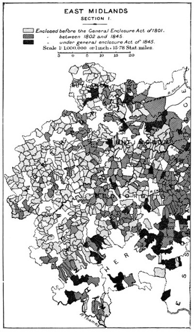
These four counties may be said to form a definite group, so far as their enclosure history is concerned. The main facts of their Parliamentary enclosure are shown in the following table:—
—— Acreage Enclosed Percentage of Total Area.
By 18th Century Acts. By 19th Century Acts.
Warwick 124,828 24,731 25·0
Leicester 187,717 12,660 38·2
Rutland 37,180 10,044 46·5
Northampton 247,517 85,251 51·8
Like Bedford, they are all counties with a high proportion of enclosure by Act of Parliament; but they differ from Bedford in that their enclosure was much more preponderatingly effected in the eighteenth century. The proportion of eighteenth-century Acts is particularly high in Leicester, but the proportion of Acts earlier than 1760 is higher in Warwick than in any other county—twenty-nine out of 114. These counties comprise the district in which the greatest amount of agitation arose against enclosure in the seventeenth century, and that in which the effect of enclosure in causing depopulation through decay of tillage was most marked in the eighteenth century.
Northamptonshire.
Northamptonshire has 51·5 per cent. of its area covered by Acts of Parliament for the enclosure of whole parishes, a larger proportion than any other county. There have been passed in addition an important Act for extinguishing foreign rights in Rockingham Forest in 1796, an Act in 1812 for draining and enclosing Borough Fen, and creating a new parish to be called Newborough, and three other Acts for enclosing commons or wastes; the whole area affected by the five Acts being perhaps 15,000 acres. These being included, the total area which has undergone Parliamentary enclosure reaches 54 per cent. of the area of the county.
James Donaldson, the Board of Agriculture reporter, says that of the 316 parishes, 227 were enclosed by 1793, and eighty-nine were then in open field; and that “half of the inclosed parishes may be denominated old inclosure.”
Of the eighty-nine parishes, open in 1793, eighty-eight have been enclosed by Act of Parliament since; so that there was only one parish enclosed without Parliamentary intervention from 1793 to 1903, when the last trace of the Northamptonshire common fields was swept away by the enclosure of Sutton. This fact is remarkable, it points to a wide diffusion of ownership of lands and of rights over the land; and it should be associated with the specially strenuous resistance of Northamptonshire to enclosure in the reign of James I.
The statement that of the enclosed parishes half may be denominated old enclosure, would be more enlightening if one knew exactly what Mr. Donaldson meant by old enclosure. But we find that 113 parishes (which is as near as possible half 227) were enclosed by Acts passed in the period 1765–1792; if therefore by “old enclosure” he means enclosure dating back more than twenty-eight years, his statement would imply that there was no enclosure without an Act in that period. Nineteen parishes were enclosed by Act in the five years 1760–1764, eighteen in the period 1749–1759, and four earlier. These Acts altogether account for the enclosure of 153 out of the 227 parishes, and there is evidently a strong balance of probability that the enclosure of the remaining seventy-two took place almost entirely before the middle of the eighteenth century.
Leicestershire.
R. Monk, the reporter for Leicester, gives as an Appendix a list of the “Lordships” of that county, with the names of the Lords of the manors, or chief landowners, and the date of enclosure, when he could ascertain it. He only knew of ten open field parishes and of two half open and half enclosed; but, of these, four, Cold Overton, Cole Orton, Whitwick and Worthington, have not since been enclosed by Act of Parliament; they must therefore have been enclosed voluntarily at the end of the eighteenth or in the first half of the nineteenth century; for the tithe documents for these parishes do not indicate any surviving common field. For thirty-five of the parishes not enclosed by Act of Parliament, Monk gives no information; of the following fifteen he gives the date of enclosure:—
Parish. Enclosed.
Shanktons 1738
Birstall 1759
Beeby 1761
Thurnaston 1762
Saxelby 1765
Frisby 1769
Stretton Parva 1770
Stapleford 1772
Shearsby 1773
Hathorn 1777
Ilston 1788
South Kilworth 1789
Hose 1791
Barkston and Plunger 1791
The following fifty-five he merely describes as “enclosed”:—
Allexton
Aston Flamville
Barwell
Bittesby
Blackfordby
Brooksby
Broughton Astley
Burrow
Burton-by-Prestwould
Cadeby
Carlton
Coston
Cotes
Dadlington
Dalby-in-the-Wolds
Great Dalby
Dishly Grange
Eastwell
Edmundthorpe
Fenny Drayton
Foolesworth
Gaddesby
Garthorpe
Galby
Goadby
Hether
Huncote
Ibstock
Isley Walton
Knossington
Lockington
Loseby
Market Bosworth
Potters Marston
Misterton
Normanton-on-the-Heath
Odstone
Rollestone
Saxby
Snareston
Stapleton
Stretton Magna
Swepston
Thorpe Arnold
Thurnby
Tilton-on-the-Hill
Twycross
Ullesthorpe
Welham
Little Wigston
Witherby
Woodthorpe
Owston
Staunton Harold
Wanlip he describes as enclosed lately.
The following forty he describes as “old enclosure,” or gives seventeenth-century dates for their enclosure—
Ashby Folville
Great Ashby
Barlston
Buckminster
Beaumont Leys
Burbage
Burton Lazars
Braunston-by-Kirkby
Carleton Curlew
Catthorp
Cossington
Cotterback
Little Dalby
Elmesthorpe
Enderby
Foston
Freathby
Glen Parva
Kirkby Beler
Lodington
Muston
Nailston
Newton Linford
Packington
Peatling Magna
Prestwould
Ragdale
Scraptoft
Shawell
Staunton Wyville
Stoke Golding
Thedingworth
Thorpe Sacheville
Welby
Willoughby Waterless
Wyfordby (or Wiverby)
Wymondham
Pickwell, he says, was enclosed in 1628, Shenton in 1646, and Laughton in 1665.
Here, again, in interpreting these statements, we are confronted with the difficulty of determining what antiquity is implied by the term “old enclosure,” and also by the difficulty of estimating what proportion of the parishes described merely as “enclosed” belonged to any particular epoch of enclosure.
On the one hand, we note (1) that one-third of the open field parishes known to Monk were enclosed without Acts in the following half-century, (2) that he gives the date of enclosure of fifteen other parishes for which we have no Acts, which were enclosed in the previous half-century. It would therefore appear that a very considerable amount of enclosure was going on, without Acts of Parliament, during the period in which Parliamentary enclosure was proceeding rapidly.
On the other hand, the fact that he can give seventeenth-century dates for the enclosure of three parishes suggests that probably a very large proportion of his “old enclosure parishes” and a fair proportion of his enclosed parishes were enclosed in the seventeenth century.[93]
Pursuing the inquiry backwards, we find our next source of information in Celia Fiennes, a lady of Newtontony, who made a series of rides in the last few years of the seventeenth century. Newtontony is three miles east of Amesbury, amid the open chalk hills, or, as she describes it, in the midst of “a fine open champion country”, and she usually describes the aspect of the country she passes through. She travelled westwards to Land’s End, eastwards to Kent, northwards to the Border, and she gives some information with regard to the state of enclosure of most of the English counties. She went through both Bedfordshire and Northamptonshire, but with regard to those two counties gives no information as to their condition of enclosure. As she is more apt to notice the presence than the absence of hedges, this, so far as it goes, confirms our conclusions with regard to Bedfordshire; and, with regard to Northamptonshire, this small piece of negative evidence tends to the conclusion that that county also was almost entirely open in the beginning of the eighteenth century.
“Leicestershire,” she says, “is a very Rich Country—Red land, good corn of all sorts and grass, both fields and inclosures. You see a great way upon their hills the bottoms full of Enclosures, woods, and different sorts of manureing and herbage” (p. 133).
It is evident that enclosure had considerably advanced; but it must be noted that “fields” with Celia Fiennes means common fields. It is further to be noted that her description of the enclosures creeping up the hills implies a process of gradual enclosure. Of the neighbourhood of Bosworth (in the west of Leicestershire) she says, “this is a great flatt full of good Enclosures.” The western side of Leicestershire was therefore mainly enclosed before 1700, while the north-east was all open till 1760.
But though enclosure was so far advanced in Leicestershire, “their fewell,” Celia Fiennes says, “is but cowdung or Coale.” The use of cowdung for fuel supplied to advocates of enclosure in the seventeenth and eighteenth centuries one of their chief arguments. Either the hedges of Leicestershire were not yet able to supply enough wood for fuel, or the old custom continued although it was as unnecessary as objectionable. In either case the natural inference is that much of the enclosure of Leicestershire which Celia Fiennes observed, was then recent.[94]
This again is confirmed by Walter Blyth, who in the passage quoted above describes Leicestershire as entirely open, as well as Northampton, Rutland, and the south part of Warwick.
Further detailed information is given by the disputants Joseph Lee, John Moore, and the anonymous writers who joined in the controversy, who debated the ethics of enclosure in the Midlands in the years 1653–1657. John Moore, in his first pamphlet, asks, “Above one hundred touns inclosed in Leicestershire, how few amongst them all are not unpeopled and uncorned?” Now it is probably fair to read “above one hundred” as “about one hundred” or “nearly one hundred.” The names of some of these are supplied by Joseph Lee in his “Vindication of Regulated Enclosure,” for he gives (page 5) as examples of enclosure without depopulation the following thirteen parishes in Leicestershire: Market Bosworth, Carlton, Coten, Shenton, Cadesby (Cadeby), Bilson (Billesdon), Twicriss, Higham, Golding (Stoke Golding), Little Glen, Croft, Ashby Magna, and Stapleton, together with Stoke in Northamptonshire, Upton and Barton, which might be either in Northampton or in Warwick, and three others, Nelson, Cosford and Woscot, which I am unable to locate, except that Cosford was near Catthorp, the extreme south corner of Leicestershire; for Lee further gives a list of fifteen enclosures within three miles of Catthorp, in which Cosford and Coten are included, and also Bigging, Brownsover, Shawell, Streetfield, Over, Cottesbatch, Pultney, Sturmer, Hallfield, Sister (? Siston), Moorebarn, Cotes and Misterton (p. 8).
Of the former set of townships he says: “They have been enclosed some twenty, some thirty, some forty or fifty years.” Of the latter he says: “Most of these Inclosures have been plowed within thirty years, and the rest are now about to be plowed.”
It would appear, therefore, that enclosure began in Leicestershire at about the beginning of the seventeenth century, and proceeded so rapidly that nearly a hundred townships, mainly situated in the south and west of the county, were enclosed within about fifty years. Enclosure also began in Northamptonshire about the same time, but at not so great a rate. The author of “Considerations Concerning Common Fields and Enclosures,” published in 1653, makes a reference to “Mr. Bentham’s[95] Christian Conflict” (p. 322), which gives a list of eleven manors in Northamptonshire, enclosed and depopulated. In a later sermon, “A Scripture Word against Inclosures,” 1656, John Moore says: “England (especially Leicestershire and the counties round about) stands now as guilty in the sight of God of the sinnes in the text. They sold the righteous for silver and the poor for a pair of shoes, as Israel did then” (p. 1). A little later he again referred to “Enclosure in Leicestershire and Northamptonshire, and the counties adjacent.” This confirms the conclusion reached from the other evidence that Leicestershire was in the centre of the seventeenth-century movement of enclosure of common fields, and that it was in Leicestershire that the movement was most effective.
Rutland.
Rutlandshire has had 46·5 per cent. of its area enclosed by Acts of Parliament, 47,224 acres. Of this area 14,641 acres were enclosed by Acts passed between 1756 and 1773; then for twenty years there were no Acts, the next being passed in 1793. By that and subsequent Acts 32,583 acres were enclosed.
John Crutchley, the Board of Agriculture reporter, says that two-thirds of the country was enclosed, one-third unenclosed (“Agriculture of Rutland, 1793,” p. 30). As the area (32,583 acres) is just one-third of the total area of Rutlandshire (97,273 acres), Acts of Parliament entirely account for all the enclosure since 1793. Of the area enclosed before 1793 there remains about 50,000 acres, a little more than half the county, unaccounted for.
Part at least must have been enclosed before the beginning of the eighteenth century, for Celia Fiennes says: “Rutlandshire seems more woody and enclosed than some others” (p. 54). It is one of the counties described by Walter Blyth as entirely unenclosed in 1649; but, as we have seen, this description is also applied by him to Leicestershire and Northamptonshire, and as it was, especially in the case of the former county, decidedly too sweeping, we cannot infer that no enclosure took place in Rutlandshire before that date.
Leland passed through Uppingham and Stanford; he found part of the county woody, but he makes no mention of enclosure.
He also gives a very full description of the counties of Leicester and Northamptonshire. Charnwood Forest in Leicestershire, and Rockingham Forest in Northamptonshire, were then very extensive; but all the remainder of the two counties he describes in general as “champaine,” or by words which imply an unenclosed condition. The only mention of enclosure is in the case of two parks in Northamptonshire. (See Appendix C.)
Warwick.
Warwickshire is divided by the River Avon into two parts of approximately equal area; the north-western part is a district of ancient enclosure, probably enclosed in the main direct from the forest state; the south-eastern part has a similar enclosure history to Leicester and Northampton, except that its enclosure took place generally somewhat earlier. One-quarter of the whole county has undergone Parliamentary enclosure, but the proportion so enclosed of the south-eastern part is much larger.
John Wedge, the Board of Agriculture reporter, estimates that in 1793, out of a total area of 618,000 acres, 57,000 was open field land (p. 11). To reduce 618,000 to the true area of the county (577,462 acres), one must deduct 10 per cent. A deduction of 10 per cent. leaves about 51,000 acres of common field. Enclosure Acts since account for 38,444 acres, and in parishes not enclosed by Acts the tithe documents indicate rather over 1000 acres of common field lands. There remains a little over 10,000 acres unaccounted for, which has disappeared between 1793 and the date of tithe commutation.
John Wedge appears to have attempted a list of open field parishes with their area and extent of common field and waste, but only got so far as to supply this information for five parishes (p. 54), each of which has undergone subsequent enclosure by Act of Parliament. He draws attention to the contrast between the two parts of Warwickshire: “About forty years ago the southern and eastern parts of this county consisted mostly of open fields. There are still about 50,000 acres of open field land which in a few years will probably all be enclosed. These lands, being now grazed, want much fewer hands than they did in the former open state. Upon all inclosures of open fields the farms have generally been made much larger. For these causes the hardy yeomanry of country villages have been driven for employment into Birmingham, Coventry, and other manufacturing towns.”
About 90,000 acres was enclosed by Act of Parliament in the part of Warwick described between 1743 and 1798. This, together with the 50,000 acres remaining, amounts to rather less than half the area of the division of the county under consideration. As Wedge clearly was of opinion that the greater part of S.E. Warwick was open at the date he mentions, and as there is no reason for thinking he was wrong, it is to be inferred that a considerable amount of non-Parliamentary enclosure was going on in S.E. Warwick during the second half of the eighteenth century.
The extracts above given with reference to Leicester and Northampton also prove that enclosure was going on in this part of the county during the first half of the sixteenth century, though it had so little advanced up to 1649 that Blyth speaks of this part of the county as unenclosed.
Leland gives an extremely full account of the state of enclosure of Warwickshire, which shows that as early as 1540 the north-west part of the county was “much enclosed.” It was on one of his later journeys that he explored the county, entering from Oxfordshire. He found, “Banbury to Warwick, twelve miles by Champaine Groundes, fruitful of corne and grasse, and two miles by some enclosed and woody groundes” (Vol. IV., Part 2, fol. 162).
“I learned at Warwick that the most part of the shire of Warwicke, that lyeth as Avon River descendeth on the right hand or ripe of it, is in Arden (for soe is the ancient Name of that part of the shire); and the ground in Arden is much enclosed, plentifull of grasse, but not of corne. The other part of Warwickshire that lyeth on the left hand or ripe of Avon River, much to the south, is for the most part Champion, somewhat barren of wood, but plentifull of corne” (fol. 166 a).
We may add, so as to complete our review of the evidence, that William Marshall, in his book on the “Agriculture of the Midland District of England” (1790), treats a region of which the town of Leicester was near the centre, comprising the counties of Warwick, Rutland, the north of Leicester and of Northampton, the east of Staffordshire, and the southern extremities of Derby and Nottingham, as an agricultural unit. He says: “Thirty years ago much of this district was in an open state, and some townships still remain open; there are others, however, which appear to have been long in a state of enclosure, and in which, no doubt, the present system of management originated” (p. 8). This does not add to our information about this district, but the fact that Marshall was perfectly correct in his reading of the story told by the aspect of the country is important, because for some other districts his testimony is material.
To sum up, we find that in the north-west of Warwick enclosure was general as early as 1540, while it was practically non-existent in the south-east of that county and in Leicester, Northampton and Rutland. We find that the movement towards enclosure of the “champaine” country began about the year 1600, that it proceeded steadily in spite of great popular resistance through the seventeenth century, but at a much greater rate in Leicester, and probably in S.E. Warwick, than in Northamptonshire, the rate in Rutland being probably slower than in Leicester, but certainly greater than in Northamptonshire, the course of the movement being from west to east; that about half of S.E. Warwick and of Leicester was enclosed when the movement of Parliamentary enclosure began, but less than half of Rutland, and not more than quarter (probably not more than a fifth) of Northamptonshire.
We have seen that the enclosure of Bedford was later than this, and we shall see that the same is true of Cambridgeshire and Huntingdon. In the midlands of England the course of enclosure from 1600 onwards was from west to east.
A word may be added with regard to the methods by which non-Parliamentary enclosure was effected in this district. There was great diversity in Leicestershire from village to village with regard to the diffusion of property, as may be seen from Monk’s Appendix, in which he endeavours to give the names of the principal owners in each “lordship.” Some were entirely in the hands of a single individual, others had many owners, but in the great majority the land was mainly, but not entirely, owned by the lord of the manor. The description of the enclosure of S.E. Warwick supplied by John Wedge, the consolidation of farms, and the depopulation of the villages, indicates that there enclosure, whether by Act of Parliament or not, was carried through by the authority of the lord of the manor, he being the main landowner.
The method by which this would be done when an Act of Parliament was not resorted to is fully explained by Edward Lawrence (“The Duty of a Steward to his Lord, 1727”), Article XIV.
“A Steward should not forget to make the best Enquiry into the disposition of any of the Freeholders within or near any of his Lord’s Manors, to sell their Lands, that he may use his best Endeavours to purchase them at as reasonable a price as may be for his Lord’s Advantage and Convenience ... especially in such Manors where improvements are to be made by inclosing Commons and Common Fields; which (as every one, who is acquainted with the late Improvements in Agriculture must know) is not a little advantageous to the Nation in general, as well as highly profitable to the Undertaker. If the Freeholders cannot all be perswaded to sell, yet at least an Agreement for Inclosing should be pushed forward, by the Steward, and a scheme laid, wherein it may appear that an exact and proportional share will be allotted to every proprietor; perswading them first, if possible, to sign a Form of Agreement, and then to chuse Commissioners on both sides.... If the Steward be a Man of good sense, he will find a necessity of making use of it all, in rooting out superstition from amongst them, as what is so great a hindrance to all noble Improvements.” The superstition referred to, is that enclosed land is cursed, and doomed in three generations to pass out of the hands of the descendants of the proprietor who enclosed it.
That in the early seventeenth century much of the enclosure was carried out by the power of the lord of the manor is plain from the scraps of information given by John Moore. Thus he tells us that Ashby Magna was enclosed in 1606, and that the lord gave most of his tenants leases for three lives and twenty-one years after (“Scripture Word Against Inclosures,” p. 9), that being the reason why depopulation had not resulted up to 1656; that in both Misterton and Poultney no house at all was left except the minister’s, so that these two manors must have been the property of absentee landlords.
But Catthorpe had no lord of the manor, it consisted of 580 acres divided among eight freeholders and five or six holders of “ancient cottages” who were also Freeholders (Joseph Lee, p. 5). The enclosure was carried out by the agreement of all the owners, except one who objected on conscientious grounds. The way in which these agreements to enclose were effected in parishes where property was divided is thus described by Moore:—“In common fields they live like loving neighbours together for the most part, till the Spirit of Inclosure enter into some rich Churles heart, who doe not only pry out but feign occasions to goe to law with their neighbours, and no reconcilement be made till they consent to Inclosure. So this Inclosure makes thieves, and then they cry out of thieves. Because they sold the righteous for silver, and the poor for a pair of shoes. If it had not been for two or three righteous in many Townes of these Inland Counties, what desolation had there been made ere this time?” (Scripture Word, p. 12).
Cambridge and Huntingdon.
Much of these two counties anciently consisted of fen and marsh, and of the land now cultivated a great deal never passed through the common field system. But the “upland” of each county was very late in undergoing enclosure.
Vancouver, the reporter for Cambridgeshire, gives an estimate of the areas of lands of different description, which I slightly rearrange below.
—— Unenclosed. Enclosed. Doubtful.
Acres. Acres. Acres.
Enclosed arable — 15,000 —
Open field arable 132,000 — —
Improved pasture — 52,000 —
Inferior pasture — — 19,800
Improved fen — 50,000 —
Woodland — — 1,000
Waste and unimproved fen 150,000 — —
Half-yearly meadow land 2,000 — —
Highland common 7,500 — —
Fen or moor common 8,000 — —
Heath and sheepwalk 6,000 — —
305,500 117,000 20,800
Total area, 443,300 acres.
The actual area of Cambridgeshire is 549,723 acres; but Vancouver was an exact and careful observer, and the proportions between the areas assigned to each description were no doubt reasonably accurate. Here we find over two-thirds of the total area unenclosed, and more than eight-ninths of the arable land. It is, of course, possible, probable even, that a larger amount than 15,000 acres of open field arable had undergone enclosure, and that the 52,000 acres of improved pasture includes a good deal of such land, laid down in grass on enclosure. But even if we included the whole, there would only be 67,000 acres of ancient common field arable which had undergone enclosure, compared with 132,000 acres still open.
Vancouver also gives detailed accounts of ninety-eight of the Cambridgeshire parishes, eighty-three of which were open, fifteen enclosed. Of those which were open in 1793, seventy-four have since been enclosed by Act of Parliament, nine have not, viz., Babraham, Boxworth, Downham, Ely, Littleport, Lolworth, Madingley, Soham and Over.
Babraham had 1,350 acres of common field, and Vancouver says that enclosure was desired. It was completely effected before the date of tithe commutation.
Boxworth had 900 acres of common field. “The whole of this parish,” says Vancouver, “lies within a ring fence and containing 2,100 acres, is the property of one gentlemen.” Vancouver’s acres, as we have seen, are large ones; the actual area is 2,526 acres. Enclosure was effected before the date of tithe commutation, and as might be supposed under the circumstances, without an Act.
Downham had, according to Vancouver, 680 acres of common field; the tithe map indicates 450 acres still remaining.
To Ely he assigns 2,100 acres of common field. This had all gone at the time of tithe commutation.
Of 345 acres assigned to Littleport, a remnant of forty acres survived to be recorded in the tithe map.
The common field land of Lolworth suffered no diminution; for while Vancouver gives it 650 acres, the tithe map indicates 800 acres. They were enclosed at the time of the Crimean war by common agreement of the owners, without an Act. This was the last surviving common field parish in the vicinity.
In Soham enclosure was nearly as slow. Vancouver assigns it 1,200 acres of common field; the tithe map 1,100 acres.
Madingley, Vancouver says, had 1,030 acres of common field. These were all enclosed before the date of tithe commutation.
For Over the Board of Agriculture has no tithe documents; but we may add that Horseheath had about 750 acres of common field, out of a total of 1,850 acres, according to the tithe map.
Of the fifteen parishes stated by Vancouver to have been enclosed before 1793, only two were enclosed by Act of Parliament.
The extent of the information obtained from the Acts, the tithe documents, and Vancouver’s report is as follows:—
Of the 152 agricultural parishes of Cambridgeshire, we know the date of enclosure of 118, enclosed by Acts of Parliament. These are given in Appendix B.
Of thirteen, viz., Arrington, Childerley, Chippingham, Hatley St. George, Leverington, Newton in the Isle of Ely, Outwell, Tadlow, Tid St. Giles, Upwell-cum-Welney, and Wisbeach St. Mary, we know that they were enclosed without Acts before 1793. The date 1790 is given for Chippingham, and a small remnant of common field survived till 1851 in Newton.
Four parishes were enclosed, not by Acts, between 1793 and the date of tithe commutation—Babraham, Boxworth, Ely and Madingley.
Five parishes which were not entirely enclosed even at the date of tithe commutation have not been enclosed by Act since. These are Lolworth, which then had only about one-fifth of its area enclosed; Horseheath, which was about half enclosed; Soham, which had about 1,100 acres of common field and 456 acres of common, out of a total area of nearly 13,000 acres; and Downham and Littleport, which had respectively 450 and forty acres of common field remaining.
Of one parish, Over, we only know that it was open in 1793.
Of nine parishes, Borough Green, Croydon-cum-Clapton, East Hatley, Papworth St. Agnes, Long Stanton, Westley Waterless, Wisbeach St. Peter, Witcham and Witchford, we only know that they were enclosed before the date of tithe commutation.
Of two, Little Gransden and Stanground, we have no information.
I have before laid stress upon the eastward march of enclosure in the midlands during the sixteenth, seventeenth, and eighteenth centuries, which the following comparison illustrates:—
— Parliamentary Enclosure.
In the 18th Century. In the 19th Century.
Acts. Acres. Acts. Acres.
Warwick 91 124,828 23 24,731
Cambridge 23 51,028 85 147,311
Celia Fiennes traversed the county. She describes the part from Littlebery (in Essex) to Cambridge as entirely open (p. 48), and makes no mention of enclosures in the description of the view from the “Hogmogoge Hills” (p. 49), but she speaks of “good enclosure” between Cambridge and Huntingdon.
Though Cambridgeshire was on the whole so late in undergoing enclosure, the conversion of arable into tillage had so far proceeded that about one-fifth of the county was included in the Inquisition of 1517, and it was found that in this part 1,422 acres had been enclosed and converted into parks or pasture (Leadam, “Domesday of Inclosures”).
Huntingdon.
George Maxwell, the Board of Agriculture reporter, says that Huntingdon contains one hundred and six towns and hamlets, of which forty-one were then (1793) wholly enclosed, and of the remaining sixty-five a very considerable part was enclosed. He computes that about a half of the “high land part” of the county, which would, of course, include all old arable land, was still unenclosed (“Agriculture of Huntingdon,” p. 16).
Fifty-eight parishes were enclosed by Acts subsequently to the date of his report, and one parish (Lutton) remained open to the date of tithe commutation. This leaves six out of the sixty-five open or partially enclosed parishes of his report, in which enclosure was completed by the middle of the nineteenth century without any Act.
Of the forty-one parishes wholly enclosed before 1793, twenty were enclosed by Acts of Parliament, leaving twenty-one parishes which might have been enclosed contemporaneously without Acts, or to be assigned to the time previous to the beginning of Parliamentary enclosure.
Some of this enclosure is certainly to be assigned to an early date. Celia Fiennes, as we have seen, found more enclosure as she came to Huntingdon from Cambridge. Leland also found enclosure in the smaller county.
“From Cambridge to Elteste village al by champeyne counterey 8 miles. St. Neotes 4 miles. From St. Neotes to Stoughton Village by sum enclosid ground a 3 Miles, it is in Huntendunshir. From Stoughton to Meichdown Village a 4 Miles be much Pasture and Corne ground ... there be goodly Gardens, Orchards, Ponds, and a Parke thereby.”
THE EASTERN COUNTIES.
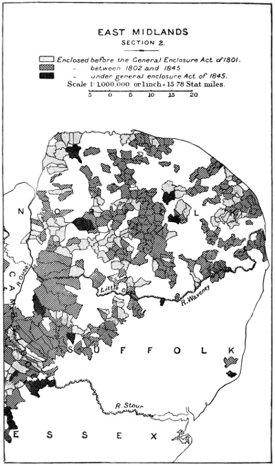
The story of the enclosure of Essex and Suffolk is almost completely told by the map. Each is sharply divided into a larger part very anciently enclosed, without Acts of Parliament, and a smaller part close to the boundaries of Hertford, Cambridge, and Norfolk, which was enclosed at a late date by Acts of Parliament. Essex has but one Act belonging to the eighteenth century, and that is dated as late as 1795. Suffolk has nine Acts belonging to the eighteenth, and forty-four belonging to the nineteenth century.
The additional information available only serves to bring out more clearly the very striking contrast between the regions of ancient and recent enclosure.
On the one hand we find that the Parliamentary enclosure of the extreme west and north-west portion of Essex is only part of the recent enclosure of that part.
The Enclosure Acts cover twenty-nine parishes, and an area of 22,000 acres, about 760 acres per parish. Vancouver, who reported on Essex, as well as Cambridge, tells us, “The arable land in about forty parishes lies very much in open common fields, and which in point of quantity is found to average 1,200 acres per parish.”[96] He gives a list of open field parishes; Thraxted and Streethall, which have not since been enclosed by Act, are included; and each of those had some common field at the time of tithe commutation.
On the other hand, he tells us that the neighbourhood of Great Dunmow, which is quite close to the region of nineteenth century enclosure, had been enclosed from time immemorial.[97]
The well-known passage in the “Discourse of the Commonweal,” “Countries wheare most Inclosures be, are most wealthie, as essex, kent, devenshire, and such,” sufficiently establishes the ancient enclosure of the greater part of Essex. And though the evidence is not very full, it is, I think, sufficient to show that the enclosure of the corresponding part of Suffolk had a similar history. Celia Fiennes says that the journey from Ipswich to Woodbridge is “7 miles mostly Lanes, Enclosed countrys”; and from Woodbridge to Saxmundham “The wayes are pretty deep, mostly Lanes, very little Commons” (p. 107).
John Norden (1602) also makes mention of Suffolk methods of hedging.
The question then arises with regard to this region of ancient enclosure in Essex and Suffolk, whether it ever passed through the typical English common field system. To this question we are able to give an unhesitating answer.
In Suffolk, far away from any other Parliamentary enclosure, in the south-east corner of the county are the parishes of Orford and Iken. The enclosure at Orford was in 1881. There were but forty-six acres to enclose, and these lay in strips alternately belonging to the lord of the manor and to the Corporation of Orford. The existence of corporate property in this small spot of land preserved it from enclosure to such a late date.
The case of Iken appears to have been somewhat similar. It was enclosed in 1804. There was only the small area of 100 acres to enclose, comprising “certain open and common fields, meadows, commonable lands, and waste grounds.” The Marquis of Hertford was lord of the manor, and six individuals by name, and “divers others” are said to be the other proprietors of land. There is a special clause authorising the parish authorities, if they will, to accept rents from the Marquis of Hertford in lieu of allotments, so there must have been corporate property in the commonable lands, and this no doubt accounted for the survival of this small area of common field.
But the clearest evidence is from the town of Colchester. The borough is of great extent, and includes the four agricultural parishes of Greenstead, Bere Church, or West Donyland, Lexden and Mile End. In these four parishes, says Vancouver, “one-third of the arable land lies in half-yearly common fields” (p. 40). The Corporation of Colchester is to this day a very large owner of arable land; how it was enclosed, and how the Corporation, as distinct from the free-men, secured the property after the passing of the Municipal Corporations Act of 1835, I do not know. The important point is conveyed in the word “half-yearly.” The arable fields of Colchester were genuine common fields, subject to rights of common of pasture after harvest.
I think there can be little doubt that though much of Essex and Suffolk might have been ancient woodland, and have been enclosed directly from that condition, the primitive village community of Essex was approximately of the same type as that of central England.
Norfolk.
Adequate material does not exist for a statistical survey of the enclosure of Norfolk, because of the disappointing habit which the promoters of Enclosure Acts for this county fell into about the year 1793,[98] and persisted in later, of not making any statement with regard to the area covered by the Act. The best statement that we can make is that 297 parishes out of 682 were enclosed by Act of Parliament.[99]
We have already dealt with some peculiar features of Norfolk agriculture revealed by preambles of Enclosure Acts. The chief other fact which is striking in its enclosure history is that the county is divided by the chalk ridge, which passes through the centre of the county, from north to south, and which reaches the coast at Cromer, into two parts of approximately equal area. The patches of colour which indicate enclosure by Act of Parliament are scattered indifferently over the whole map of the county; but the significance of the colour varies. East Norfolk has all the aspect of a country of very early enclosure. The fields are small, the hedges are big and high, like Devonshire hedges, the roads are narrow and winding. The aspect recalls Kent’s previously quoted words. “There is a considerable deal of common field land in Norfolk, though a much smaller proportion than in many other counties; for notwithstanding common rights for great cattle exist in all of them, and even sheepwalk privileges in many, yet the natural industry of the people is such, that whenever a person can get 5 or 6 acres together, he plants a white-thorn edge round it, and sets an oak at every rod distance, which is consented to by a kind of general courtesy from one neighbour to another” (“Agriculture of Norfolk,” 1st Edition, p. 22). The Parliamentary enclosure which took place in a parish where the neighbours had been showing this courtesy to one another consisted mainly in the extinction of common rights over enclosed land.
The making of hedges had proceeded to such an extent in East Norfolk by the end of the seventeenth century, that an anonymous author who brought out an annotated edition of Tusser’s “Five hundred points of Husbandry,” and “Champion and Severall,” under the title “Tusser Redivivus,” in the year 1710, explains the term “woodland” (a term which Tusser really used as a synonym for “several” or enclosed land) to mean East Norfolk, saying that this district was so much enclosed in small fields with fine trees in the hedges, that it was known as “the Woodlands.”
At this time the western half of the county was still almost entirely open. Arthur Young wrote in 1771, “From forty to sixty years ago, all the Northern and Western and a part of the Eastern tracts of the county were sheepwalks, let so low as from 6d. to 1s. 6d. and 2s. an acre. Much of it was in this condition only thirty years ago. The great improvements have been made by reason of the following circumstances:
(1) By enclosing without the assistance of Parliament.
(2) By a spirited use of marle and clay.
(3) By the introduction of an excellent course of crops.
(4) The cultivation of hand hoed turnips.
(5) Clover and ray grass.
(6) Long leases.
(7) By the county being divided chiefly into large farms.
“Parliamentary inclosures are scarcely ever so complete and general as” (non-Parliamentary enclosure) “in Norfolk” (“Eastern Tour,” Vol. II., p. 150).
William Marshall supplies a confirmatory note. “Norfolk, it is probable (speaking generally of the county), has not borne grain, in abundance, much above a century. During the passed century” (the eighteenth) “a principal part of it was fresh land, a newly discovered country in regard to grain crops” (“Review of the Reports to the Board of Agriculture for the Eastern Department,” p. 314).
Enclosure in the western half of Norfolk and along the central chalk ridge in the eighteenth and nineteenth centuries, whether common field arable were included or not, meant the reverse of what it had meant in the first half of the sixteenth century—the conversion of land from sheeprun to arable land and to highly cultivated land. Kent, in a second edition of his report of Norfolk, published in 1796, estimated that two-thirds of the whole area of the county was then arable; and of the arable land three-quarters was enclosed, one-quarter in common field. In other words, one-half of the area of the county was enclosed arable, one-sixth common field arable. The remainder he describes as follows:
Meadows, parks, and upland pasture 126,692 acres.
Unimproved commons 80,000 ″
Marsh lands 63,346 ″
Warrens and sheepwalks 63,346 ″
with small areas for woods, plantations, roads, lakes, rivers, and swamps. Whatever ancient common field arable had been enclosed before the beginning of the eighteenth century and converted into pasture, was apparently re-converted into arable before the end.
THE SOUTHERN MIDLANDS.
Middlesex.
I have found very little information with regard to the enclosure of Middlesex beyond that obtained from the Enclosure Acts. It is remarkable that these should cover so large a part (19·7 per cent.) of the area of the county.
Of twenty-six Acts, covering 35,757 acres, twenty-three, covering 30,000 acres, belong to the period after 1793. The Board of Agriculture reporters, Thomas Baird and Peter Foot, tell us respectively (1) that there were about 50,000 acres under tillage in 1793 (“Agriculture of Middlesex,” p. 7), and (2) “The Common Fields in the county of Middlesex, which are at present in a good course of husbandry, form a large proportion as to the number of acres when compared to the cultivated enclosures” (Ibid. p. 72).
That the common fields were “in a good course of husbandry” very probably means that the exercise of common rights had been largely restricted, and it is not improbable that while some of the ancient common fields of Middlesex became converted into small dairy farms, others became market gardens by means of a very moderate amount of interchanging of properties and holdings.
Hertfordshire.
The county of Hertford is rather remarkable for the extent of open field land (common rights have so far decayed that one can hardly call it common field) persisting to the present day. Notes have already been given on Hitchin, Bygrave, Clothall, and Wallington. There were further no less than seventeen enclosures under the Act of 1845, a number only surpassed by Oxfordshire, and in a number of other parishes small remnants of common fields are indicated by the tithe maps.
But on the whole Hertfordshire was a county of early enclosure. When the Board of Agriculture survey was made only four parishes and a part of Hitchin had undergone Parliamentary enclosure; but the reporter says, “There are several small common fields in this county, but these are mostly by agreement among the owners and occupiers cultivated nearly in the same way as in the enclosed state” (D. Walker, “Agriculture of Hertfordshire,” p. 49).
Walter Blyth in 1649 included “Hartford” with “Essex, Kent, Surrey, Sussex,” etc., as enclosed counties (“The English Improver,” p. 49).
“An insurrection in hertfordshire for the comens at Northall and Cheshunt,” was, according to Hales, the first beginning of the enclosure riots and rebellions in the reign of Edward VI.
It is somewhat remarkable that Hertford was in the seventeenth and eighteenth centuries so much more enclosed than the surrounding counties, than Middlesex as well as than Bedford and Cambridge, and even more enclosed than the part of Essex immediately adjoining.
Leland gives no account of the condition of the county with regard to enclosure; but as no earlier author than Blyth speaks of Hertford as an enclosed county, I am inclined to believe that its enclosure mainly took place in the sixteenth and in the first half of the seventeenth century. It is to be noticed that Hertford was excluded from the operation of the last (39 Elizabeth, c. 2) of the Depopulation Acts, requiring that all old arable land should continue under tillage and be cultivated according to the local custom.
Buckingham.
Buckingham is, on the whole, a county of late enclosure. A large proportion (34·2 per cent.) of the area was enclosed by Acts of Parliament; two-thirds of this enclosure belonging to the eighteenth and one-third to the nineteenth century.
The reporters to the Board of Agriculture, William James and Jacob Malcolm, supply a list of the parishes containing common fields in 1794, with an approximate statement of the area. The majority of these parishes have, of course, undergone Parliamentary enclosure since. By comparing their list with that of the Enclosure Acts and with the summary of the tithe documents, we find that the following seventeen parishes were enclosed without Acts between 1794 and the date of tithe commutation:—
Astwood
Buckland
Dinton
Drayton Beauchamp
Halton
Great Hampden
Little Hampden
Hedgerley
Horsendon
Great Horwood
Ickford
Marsh Gibbon
Medmenham
Great Missenden
Little Missenden
Newton Longueville
Quainton
The following five still had remains of common field at the time of tithe commutation, though the area was considerably reduced in each case:—
—— Common Field Acreage.
In 1794. According to Tithe Map.
Acres. Acres.
Burnham and Lower Boveney 1000 525
Chesham 300 66
Dorney 600 277
Eton 300 181
Chipping Wycombe 200 100
As so much gradual non-Parliamentary enclosure took place during the nineteenth century, it is to be supposed that the same process was also going on right through the eighteenth century.
Buckingham is traversed by the Chiltern Hills, and so is divided into two distinct regions. About half the county lies north-west of the Chilterns, on a sub-cretaceous formation, like Bedfordshire, with fertile soil, and villages thickly scattered. The remainder consists of the chalky downs and the later formations, like most of Hertfordshire and Middlesex.
The enclosure of the south-east portion was earlier than that of the north-west part. Arthur Young in 1771 was much struck by the extent of the open fields in the latter part. The vale of Aylesbury,[100] he says, was good clay, and open field (“Eastern Tour,” p. 18). From Aylesbury to Buckingham “nearly the whole country is open field, the soil among the richest I ever saw, black putrid clay” (p. 19). “As for the landlords, what in the name of wonder is the reason of their not enclosing! All this vale would make as fine meadows as any in the world” (p. 23). However, about Hockston (Hoggeston) he saw many new enclosures (p. 24). Hoggeston itself was never enclosed by Act, but several neighbouring villages had been enclosed by Acts passed previously to 1771.
Celia Fiennes passed through the same part of Buckinghamshire about eighty years before. From Stony Stratford to Great Horwood, she says, “this country is fruitfull, full of woods, Enclosures, and rich Ground. The little towns stand pretty thicke. You have many in view” (p. 97). This does not imply anything more than very partial enclosure; for Celia Fiennes, accustomed to the complete absence of hedges of her own part of Wiltshire, always notices enclosure rather than the absence of enclosure. That many little towns should be in sight of one passing through a flat country implies that it is open, except close to the villages.
Leland, in 1536, came from Bedfordshire along the boundary between Herts and Bucks and into the extreme south of Buckinghamshire, and found that enclosures had already begun. He describes the whole county in one luminous sentence, “Looke as the countrye of the Vale of Alesbury for the most part is clean barren of wood, and is champaine, soe is all the Chilterne well woodid and full of Enclosures” (fol. 192 a).
It seems quite clear, then, that the enclosure movement of the south-east of Berkshire was ancient; that it moved up the long slope of the Chilterns from the Thames and Middlesex, but stopped at the open chalk downs which marked the summit of the range; and that the movement which affected the enclosure of the Vale of Aylesbury and all north-western Buckinghamshire was part of the general enclosure movement of the Midlands, spreading southwards from Leicester and Northampton, as we have seen it spread eastwards.
Oxford.
Oxfordshire may be termed a sister county to Buckinghamshire; but by far the greater part of the county lies north-west of the Chiltern Hills, which occupy the south east extremity. We find, as we should expect, that the history of the enclosure of Oxfordshire resembles that of Bedfordshire and of North-West Buckinghamshire; 45·6 per cent. of the area of Oxfordshire underwent Parliamentary enclosure compared with 46·0 per cent. of Bedfordshire and 34·2 per cent. of Bucks; in Oxford about 62 per cent. of the total Parliamentary enclosure belonged to the eighteenth century, in Bedford 54 per cent., in Buckinghamshire 66 per cent. Oxford, however, is remarkable for the extent of the enclosure (eighteen Acts enclosing 23,578 acres) under the General Enclosure Act of 1845.
Richard Davis, the Board of Agriculture reporter, while he gives a very full statement of the methods of cultivating the common fields of the county, makes no statement with regard to their extent.
As in Buckinghamshire, partial enclosure, particularly in the immediate neighbourhood of the villages, had taken place before the eighteenth century. Celia Fiennes found “Oxford Environ’d round with woods and Enclosure, yet not so neare as to annoy the town which stands pleasant and Compact,” and from the Malvern Hills she says “Oxford, Gloucestershire, &c. appears in plaines, enclosures, woods and rivers and many great hills” (p. 33). By “plaines” stretches of common fields are to be understood.
Leland found no enclosure in Oxfordshire in any part he visited.
THE NORTH OF ENGLAND.
Lincoln.
Lincoln and the East Riding of Yorkshire have a similar enclosure history. Each was largely enclosed by Acts of Parliament; in each nearly four-fifths of the Parliamentary enclosure was effected in the eighteenth century; in each enclosure was not marked either by a general conversion of arable into pasture, as in Leicestershire, or by a general conversion of pasture into arable, as in Norfolk; in both a considerable proportion of the common-field land before enclosure was worked on the two-field system. As much as 40·1 per cent. of the East Riding of Yorkshire is covered by the Acts for enclosing common-field parishes, and 29·3 per cent. of Lincolnshire; but for the latter county there are also Acts for enclosing great extents of commonable marshes; and including these and other Acts for enclosing commons and wastes, about 35 per cent. of Lincolnshire has undergone Parliamentary enclosure.
A good deal of non-Parliamentary enclosure took place during the nineteenth century. Thomas Stone, the Board of Agriculture reporter, estimates that there were in 1793, 200,000 acres of commons, wastes, and unimbanked salt marshes, and 268,000 acres of common fields. He over-estimates the total area of the county so much, that to rectify his figures we have to deduct 10 per cent.—this leaves 421,000 acres of common fields and other commonable lands. There have been enclosed by Parliamentary action since 207,659 acres by Acts for enclosing common-field parishes, and about 74,000 acres by Acts for enclosing other commonable lands; if we suppose there are 12,000 acres of common fields and commons surviving, this accounts for 293,659 acres, and leaves about 127,000 acres unaccounted for—i.e., enclosed by non-Parliamentary process during the nineteenth century.
If the same proportion between the scope of the two methods be supposed to have held good during the earlier part of the period of Parliamentary enclosure, it would follow that at the beginning of that period (1730) Lincolnshire was about half enclosed and half open.
From the references to Lincolnshire by our tourists, one would expect to find a less degree of enclosure. Arthur Young, in 1768, that is, after fifty-three Enclosure Acts for Lincolnshire had been passed, found the country from Stamford to Grimsthorpe mostly open (“Northern Tour,” p. 77), from Grimsthorpe to Colsterworth chiefly open, Colsterworth to Grantham, enclosed on the right hand, open on the left (p. 84), and from Grantham to Newark all open (p. 94). Celia Fiennes, about 1695, following the same road, found no enclosures but a “fine champion country.” Leland gives the same testimony.
By comparing Celia Fiennes with Arthur Young, we have evidence of enclosure proceeding in the south-west of Lincolnshire between 1695 and 1768, which is partly, but not entirely, accounted for by Parliamentary enclosure. The three descriptions give the impression that up to the beginning of Parliamentary enclosure Lincolnshire was much less than half enclosed. It is, however, not difficult to reconcile this with the conclusion inferred from Thomas Stone’s statement and the Enclosure Acts; for none of the three travellers touched more than the western part of the county. No doubt the eastern part was earlier enclosed. This is, indeed, indicated by the distribution of Parliamentary enclosure, as shown by the map.
The East Riding of Yorkshire.
We have no estimate of the extent of common-field land in the East Riding from the Board of Agriculture reporter; but Arthur Young, in his “Northern Tour,” describes the part betwene Sheffield and Goole and the East Riding as about half open and half enclosed (pp. 172–210). He further says (p. 178) that in the East Riding “Inclosures and turnpikes were carried on with great spirit during the late war” (i.e., “The Seven Years’ War”). Nine Acts were passed for the enclosure of eleven parishes during that war; but this can only have been a part of the spirited proceedings.
As in the case of Bedfordshire, when we allow for marshes along the Humber, and hill country on the Wolds, which never passed through the common-field system, for the indubitable non-Parliamentary enclosure proceeding side by side with Parliamentary enclosure, and particularly for the active enclosure spoken of by Arthur Young in the middle of the eighteenth century, there remains but little enclosure of common fields to be attributed to earlier centuries. Some such enclosure must be assigned to the sixteenth century. The Commission of 1517 inquired into nearly the whole riding and found 1560 acres of arable land enclosed, 1545 acres of which were laid down to grass (W. S. Leadam, “The Domesday of Inclosure”).
Leland also found some enclosure in the East Riding, which he traversed pretty completely. (See Appendix C.)
We have mention of a park and of enclosed land in four different places, though in each of the four only for about a mile of the route.
The North and West Ridings.
The North and West Ridings of Yorkshire were much earlier enclosed than the East Riding. This is the natural consequence of the fact that in early times they possessed a much smaller proportion of arable land, and, as I have shown in a previous chapter, the more pasture predominates, the less the common-field arable is able to resist the tendency to enclosure. The difference between the proportions of the three ridings covered by Enclosure Acts, by which common fields were enclosed is striking: East Riding 40·1 per cent., West Riding 11·6, North Riding 6·3. But this understates the case, for I include all Acts whereby any arable common field at all is enclosed, and in the North and West Ridings many of these Acts are for the enclosure of a great stretch of moor and a mere remnant of common field, and these unduly swell the total. Examples are an Act in 1791 for the enclosure of 6000 acres of common, and 30 acres of “mesne inclosures,” i.e., of intermixed tilled land which is separated from the surrounding common pasture by a hedge; an Act in 1801 for the enclosure of 150 acres of common field and common meadow, and 4000 acres of common pasture at Kettlewell and Conistree; an Act in 1815 for the enclosure of a wretched remnant of nine acres of common field arable, and 6330 acres of common. The existence of such remnants of common field arable bears witness to the gradual enclosure which would have entirely extinguished them a little later, if the opportunity of the enclosure of the commons had not been seized to bring them also within the scope of the Acts.
William Marshall’s account of the enclosure of the Vale of Pickering has already been given. Arthur Young in 1768 describes the view from the road from Kirby Moorside to Cleveland as one of “extensive valleys cut into innumerable inclosures” (“Northern Tour,” Vol. II., p. 93). Enclosure was the rule all the way from Driffield northwards.
Celia Fiennes kept more to the West Riding. From Darlington to Richmond, “I went through Lanes and Woods, an Enclosed country” (p. 183). Richmond to Boroughbridge was for 3 or 4 miles through narrow lanes, then for 5 or 6 through common (p. 184). From Knaresborough to Leeds “it was much in Lanes and uphills and Downhills, some little part was open common” (p. 184). From Leeds to Eland “much in enclosures” (p. 185). About Eland “all the hills full of inclosures” (ibid.). From Eland to Blackstone Edge, “these parts have some resemblance to Darbyshire, only here are more woody places and inclosures” (p. 186).
The earlier history of the enclosure of most of the West Riding and North Riding is summed up in the passage from Walter Blyth:—“Woodlands wont before inclosure to be relieved by the Champion, and now become gallant corn countries.... West of Warwick, North of Worcester, Staffordshire, Shropshire, Derbyshire, Yorkshire, and all the Countries thereabouts” (“English Improver,” p. 40). For while Celia Fiennes found so much enclosure, Leland found chiefly moor and forest, yet more enclosure than “Chaumpaine.”
The great contrast between the description given by Celia Fiennes and that given by Leland sufficiently confirms the statement of Walter Blyth, which we may amplify as follows:—Enclosure made little progress in Yorkshire before the middle of the sixteenth century, but thenceforward it was pushed steadily on mainly by the tilling and enclosing of common wastes and pastures, and the clearing and cultivation of forests in the North and West Riding, and the common-field arable also underwent division and gradual enclosure. That the Vale of Pickering in the North Riding and the district between Sheffield and Goole in the West Riding, being the parts where arable common fields most predominated, were the last of the cultivated districts to be enclosed; the Vale of Pickering being mainly enclosed by non-Parliamentary means in the first half of the eighteenth century; the South Yorkshire district being largely enclosed by Acts of Parliament in the second half of the eighteenth and the beginning of the nineteenth century.
Lastly attention must be drawn to the great number of Acts of Enclosure for Yorkshire enclosing common pasture or waste only.
Nottinghamshire.
Nottinghamshire may be said to consist of an ancient “champain” district, which has an enclosure history exactly similar to that of the neighbouring districts of Northamptonshire and Lincolnshire, and an ancient forest district.
The county as a whole has a percentage of Parliamentary enclosure, 32·5, which must be considered high when allowance is made for the fact that so much land must have been enclosed directly from the forest state without passing through the common-field system. The two surviving examples of common-field parishes, Laxton and Eakring, have been before described; Bole also was till recently unenclosed.
The Board of Agriculture reporter, Robert Lowe, attempted to give an account of the state of enclosure of the different parishes in 1793, but evidently found it beyond his powers to make the lists at all complete. But his list of unenclosed parishes enables us to give the following nine parishes as enclosed without Parliamentary intervention since 1793:—
Askham
Kirklington
Rampton
Saundby
Treswell
North Wheatley
South Wheatley
Kneesall
Widnerpool
together with the hamlets of Ompton and Clipston.
And his list of recently-enclosed parishes enables us to give the following nine parishes as enclosed without Parliamentary sanction shortly before 1793:—
Bingham
Carcolston
Selston
Shelton
Cotham
Kneeton
Orston
Sibthorpe
Thoroton
together with the hamlets of Aslacton, Newton, Oldwork, and Cropwell Butler.
All these had been enclosed, he says, within the previous twenty years.
The fact that the extent of non-Parliamentary enclosure in Notts., in the period from 1773 to 1793 is just equal, according to this, to that of the non-Parliamentary enclosure after 1793, is a slight clue to the probable extent of non-Parliamentary enclosure in the eighteenth century in other counties similarly circumstanced.
We should expect, then, to find the part of the county which was anciently tilled, practically entirely open, at the beginning of the eighteenth century. This is confirmed by the evidence, so far as it goes. Celia Fiennes says: “From Nottingham Castle I saw a prospect more than 20 mile about. The land is very rich and fruitfull, so the Green meadows with the fine corn ffields which seemes to bring forth in handfulls. They soe most of Barley and have great encrease, there is all sorts of Graine besides, and plaines and Rivers and Great woods and Little Towns all in view” (p. 56).
Leland was similarly struck with South Nottingham. Coming south from Rotherham he found “very woody Grounde,” then “hethy,” then “Corny and Paster,” then “Ground very fruteful of Corne” (Vol. V., fol. 91, 92). But when he got past Nottingham the view made him burst into Latin. “After that I cam a little beyond Trent I saw all Champaine Grounde undecunque within sight, and very little wood but infinita frugum copia.”
Derby.
The enclosure history of Derbyshire closely resembles that of the West Riding of Yorkshire. A somewhat larger part (16·5 per cent.) of it underwent enclosure by Acts for the enclosure of common-field arable in conjunction with other commonable land, and about 5 per cent. more by Acts for the enclosure of common pasture and waste. The common-field arable is frequently called “mesne inclosures” (sometimes “mesne field”), showing that the idea of a hedge was that it surrounded the corn crops to keep out beasts, not the pasture to keep them in. Celia Fiennes gives a general description of the county: “You see neither hedge nor tree but only low drye stone walls round some ground, Else its only hills and dales as thick as you Can Imagine” (p. 77). “All Darbyshire is but a world of peaked hills.”
It will be remembered that it had by 1649, according to Blyth, become a gallant corn country through enclosure. Leland passed it by.
Durham.
The history of the enclosure of Durham is told by the Board of Agriculture reporter in a sentence: “In this county the lands, or common fields of townships, were for the most part inclosed soon after the Restoration.... The common fields are few in number and of small extent” (Joseph Granger, “Agriculture of Durham,” p. 43).
All other evidence simply confirms this statement. The Enclosure Acts for enclosing common fields are but five in number, and the most extensive of them covers only 800 acres, of which part only is common field. (The Enclosure Acts of the other type are numerous in comparison and extensive in scope, one covering 10,000, one 20,000, one 25,000 and one 28,000 acres).
The statement, too, is confirmed by two contemporary authors, previously quoted, and by the records of Leland and Celia Fiennes. Celia Fiennes says that from Newcastle to Durham “the whole county looks like a fruitful woody place” (p. 178), and she compares it to the neighbourhood of Blackheath (p. 179), from which we must infer some open common, but all the cultivated land in a state of enclosure.
Leland traversed the whole county but found no enclosure. Nor does he describe any part of the county as “champaine” but merely as good corn, or grass, or moor, or mountain. It is, I think, safe to conclude that there were no extensive stretches of common-field arable within view; but also, one is inclined to infer that enclosure had not yet begun.
Further, there is an illuminating note from Arthur Young (1768): “Farms become large on entering Northumberland, after the small ones of Yorkshire and Durham” (“Northern Tour,” Vol. III., p. 61).
It has to be borne in mind that the disorder on the Border checked the development of agriculture till the accession of James I., probably at least as far south as the North Riding of Yorkshire. With the gradual increase of population, and improvement of roads, cultivation spread over the wastes; first in Yorkshire, then in Durham, then in Northumberland. At first the agent was a peasant, carving a small farm for his own maintenance, later a landlord or farmer able to employ labourers and work a large farm.
That the enclosure of Northumberland took place later than that of Durham, and was the work of the eighteenth and nineteenth centuries, is on a priori grounds probable, and is further indicated by the fact that Celia Fiennes makes no mention of enclosure in her account of her ride from the Scottish border into Durham. A further reference to the enclosure of Northumberland will be made when we come to Cumberland.
THE SOUTH-EAST OF ENGLAND.
Kent.
Kent is certainly a county of very ancient enclosure. This is clearly indicated by the fact that not a single Act for the enclosure of common field has been passed by the whole county. It is also witnessed by a whole series of writers, from Boys, the Board of Agriculture reporter, who says, “There are no Common Fields in Kent,”[101] to the author of the “Discourse of the Commonweal,” “those counties which be most enclosed, as essex, kent, devenshire.”
But in Kent it would appear that if some investigator as careful as Vancouver had at a somewhat earlier date reported on the agriculture of Kent, he would have found some remains of arable common fields in the far eastern corner of the county. William Lambarde, in the “Perambulation of Kent,” 1570, says: “The soile is for the most part bountifull, consisting indifferently of arable, pasture, meadow and woodland. Howbeit of these wood occupieth the greatest portion even to this day except it be towards the east, which coast is more champaigne than the residue” (p. 3).
More than a hundred years later, Celia Fiennes says: “Canterbury to Dover was a good road and a sort of Champion Country” (p. 103). It was open, it was mainly arable land, but it differed in some respect from the Champain of the Midlands; and again, a hundred years later, William Marshall writes in 1798 of the Isle of Thanet: “The whole country lies open, excepting in the immediate environs of villages.... The present productions, if we cut off the marsh lands, may be said to be arable crops” (“Southern District,” Vol. II., p. 6).
This was written, it will be noticed, just after Boys had written his statement that there were no common fields in Kent. We can reconcile the two statements if we suppose that by the disuse of rights of common, and by the consolidation of scattered properties and holdings by mutual exchanges, the characteristics of common field had been abolished, while in consequence of there never having arisen any tendency to convert the arable land into pasture, no necessity for the expensive labour of making hedges arose. But I have no evidence to show at what date the open arable land ceased to be common field.
The question arises whether the common-field system of the ordinary English type ever existed in this part of Kent; and here again there is no decisive evidence that I know of by which to answer the question. The fact that the similar question for Essex is answered in the affirmative by the Colchester common fields perhaps counts for something; and that the Surrey common fields come at Croydon close to the county boundary, for a little more. At Eltham there is an old charity called the Fifteen Penny Lands; only a few acres remain in the form of land, the rest having been sold and the proceeds invested; but there still remains an acre described as “Land in East Field, Dockland’s Shot.” In 1578 a member of the Roper family, perhaps Margaret Roper, the daughter of Sir Thomas More, or her husband, bequeathed to Eltham “a parcel of ground containing by estimation four acres, in the common field, called East Field.”[102] Eltham was a royal manor, hence likely to preserve old customs to a later date than other manors, and the arrangement of ancient common fields, particularly towards Eltham Common, seems clearly traceable. In Addington, an ecclesiastical manor, it seems easy to trace the signs of ancient common, commonable meadow, and common fields.
The Weald.
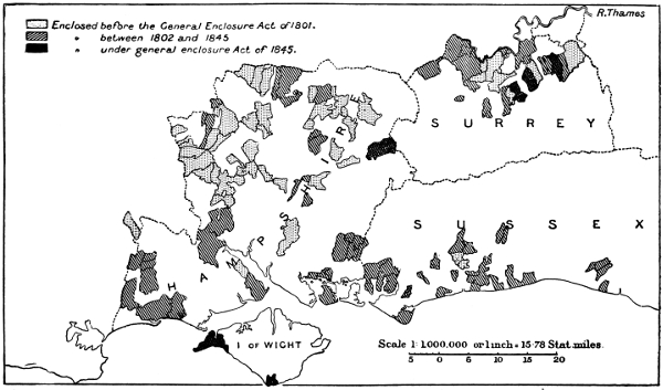
The whole of the Weald of Kent, Surrey, and Sussex appears never to have passed through the common-field system. This is indicated in the first place by the fact that there have been no Enclosure Acts for enclosing common fields. Secondly, we have what may be termed the expert evidence of William Marshall, the shrewdest of all the eighteenth-century agricultural writers, and the only one really interested in the origin and early history of the common-field system. He says of the Maidstone district, “the entire district appears to have been inclosed from the forest or pasture state. I observed not a trace of common-field lands” (“Southern District,” Vol. I., p. 21). Of the Weald of Kent, “The whole is in a state of inclosure, and mostly divided by wide woodland belts, into well sized fields” (Ibid., p. 345). Of the Weald of Sussex, “... there being, I believe, no trace at present, of common fields having ever gained an establishment” (Vol. II., p. 100). “The whole of the district (between Pulborough and Midhurst) under view is in a state of Inclosure; except a few small heathlets and commons; and except a small remnant of common field in the Maam soil.” The Maam soil, he says, is a vein of land of peculiar nature at the foot of the chalk hills, to be identified, presumably, with the Gault formation.
In 1649, seeing that a considerable amount of common field survived in the part of Surrey north of the North Downs, until the time of Parliamentary enclosure, and some in Sussex south of the South Downs, and in spite of this, Blith speaks of Surrey and Sussex as enclosed counties, enclosure must at least have predominated in the Weald.
Celia Fiennes adds a confirmation. Sussex, she says, is “much in blind, dark lanes” (p. 32). This implies narrow roads, with well-grown hedges, that is, ancient enclosure. For roads are everywhere broad in proportion as the industrial state at which enclosure takes place is advanced. Again, from Calvery to Branklye, “the way is thro’ lanes, being an Enclosed Country for the most part, as is much of Sussex which joyns to Kent” (p. 112). And the view from Boxhill was that of “a fruitfull vale, full of inclosures and woods” (p. 32).
North Surrey.
The part of Surrey which lies on the north slope of the North Downs, from the Kent boundary to the Bagshot sands, contained up till the time of Parliamentary enclosure a considerable proportion of common-field land, as may be seen by the appendix and the map.
James and Malcom, the reporters for Surrey, give a list of the chief common fields remaining in 1793 (“Agriculture of Surrey,” p. 43), from which we find that besides Merrow, enclosed about 1870, East and West Clandon, Ashtead and Thorpe have been enclosed without Acts since. In each of these four cases enclosure took place before the date of tithe commutation.
But even this part of Surrey must be considered as on the whole an early enclosed district; as much so, in fact, as the corresponding slope of the Chiltern Hills, and the Hertfordshire Hills on the other side of the Thames.
The Sea Coast of Sussex.
The western part of the south slope of the Sussex Downs has a few examples of common fields surviving to a late date, but they are fewer in number and smaller in area than on the north slope of the Surrey Downs. William Marshall says: “In the Isle of Selsey I observed some common field land; also about Chichester, in the year 1791” (Southern District, Vol. II., p. 230.) The accompanying map shows the parishes enclosed by Acts.
Wessex.
Under the heading of Wessex I include the counties of Hampshire, Wiltshire, Berkshire and Dorset. There is a close resemblance between the enclosure history of each of these; while Gloucester is a connecting link between them and the Midland counties on the one hand, and the south-western on the other. It may be described as at present a country of very large farms, with a very large proportion of open down, the cultivated land itself remaining remarkably open, being divided in general into large rectangular fields by hedges which are frequently full of gaps. Rights of common here more than elsewhere have decayed, irrespective of actual enclosure; and using the word enclosure in its broad sense, it may be said that in Wessex the process of enclosure has least of all taken visible shape, either in the growing of hedges, or building of walls, or in the conversion of arable to pasture, or pasture to arable, or in the scattering of the habitations of the inhabitants over the whole parish; but that it has most profoundly affected the social life of the villages. The case of Grimstone, in which the nine “livings” for generations held by about a dozen different copyholders, was converted into a single farm, and by no means an exceptionally large one, is typical of the whole district. This aspect has been previously treated. What here has to be noticed is that these characteristics of Wessex enclosure make it more difficult to trace the progress, at least so far as the higher lands are concerned. If Celia Fiennes could revisit the neighbourhood of Amesbury and Stonehenge, she would probably again describe it as “all on the downs, a fine champion country.” It is fortunate that we have the accounts of two such expert observers as Thomas Davis and William Marshall. They wrote practically at the same date, Marshall apparently in 1792, Davis in 1793; but as Marshall confines himself to the actual condition, while Davis deals with the past, he must here take precedence.
“The Western Chalk Hills.
“Basingstoke to Salisbury.—The state of inclosure varies. To the eastward the country is mostly inclosed, much of it in large, square, regular inclosures. More westward, it is entirely open; as are the tops of the higher hills throughout. Extensive views, with no other break, than what is given by corn or flocks, fallows or the sheep fold.
“Environs of Salisbury.—To the southward of the town there are some well-sized, square fields, with good live hedges (at least on three sides) apparently of forty or fifty years’ growth; yet, extraordinary as it is, many of these fields lie open to the roads; the fences on the sides next the lanes lying in a state of neglect. And, to the north of the Avon, the country for many miles every way, lies open, unless about villages and hamlets, and along the narrow bottoms of the watered valleys. To the eastward of Salisbury an attempt has been made at inclosure; the ruins of the hedges are still evident; broken banks, with here and there a hawthorn. And similar instances are observable in other parts of the Downs.
“Are we to infer from hence, that chalk down lands are not proper to be kept in a state of inclosure? Or that where sheep are kept in flocks, and few cattle are kept, fences are not requisite? Or is the foliage of shrubs a natural and favourite food of sheep, and hence, in a country chiefly stocked with sheep, it is difficult to preserve a live hedge from destruction?
“Ludgershall to Basingstoke.—The country is wholly inclosed: excepting a few plots to the right; mostly in large square fields, doubtless from a state of open down; the hedges in general of a Middle Age; some instances of vacant inclosure.
“With respect to the present state of appropriation of this tract of country,[103] the mere traveller is liable to be deceived. From the more public roads, the whole appears to be in a state of divided property. But on a closer examination, much of it is found to be in a state of commonage. In the immediate environs of Salisbury, there are evident remains of a common field, lying in narrow strips, intermixed, in the south of England manner; and not far from it, a common cow pasture and a common meadow. About Mere” (on the Somerset border of Wiltshire) “I observed the same appearances. In the Valley of Amesbury much of the land remains, I understand, under similar circumstances, though they do not so evidently appear in the arable lands, which by the aggregation of estates, or of farms, or by exchanges among landlords and their tenants, lie mostly in well-sized pieces. But the after-eatage,[104] whether of the stubbs or the meadows, is enjoyed in common. And the grass downs of the common field townships are in a state of common pasture the year round; being stinted by the arable lands” (“Southern District,” p. 308, etc.).
One fact to be noticed is that Hampshire was earlier enclosed than Wiltshire; which is in accordance with what one would have expected. Enclosure spread westwards into Hampshire from Surrey and Sussex.
Davis I have previously quoted. “The greater part of this county (Wiltshire) was formerly, and at no very remote period, in the hands of great proprietors. Almost every manor had its resident lord, who held part of the lands in demesne, and granted out the rest by copy or lease to under tenants, usually for three lives renewable. A state of commonage, and particularly of open common fields, was peculiarly favourable to this tenure. Inclosures naturally tend to its extinction.
“The North-West of Wiltshire being much better adapted to inclosures and to sub-division of property than the South, was inclosed first; while the South-East or Down district, has undergone few inclosures and still fewer sub-divisions” (“Agriculture of Wiltshire,” p. 8).
We have previously seen that Cobbett, traversing that same South-East district of Wiltshire, found in 1825 the common field or “tenantry” system completely superseded by that of great farms. Parliamentary enclosure only partly effected the change, which appears to have been so complete in the space of a single generation, 1793–1825. The violent fluctuations in the price of grain during the great war, the wholesale ruin of farmers in 1815 and 1816, the abuse of the Poor Law peculiarly rampant in Wiltshire, by which the peasants who held such little holdings as we have observed in Fordington and Stratton and Grimstone, by lease or copy, were compelled to pay in their rates the wages of the labourers employed by the great farmers who were superseding them, and the decay of home industries to which Cobbett bears witness, all these were complementary parts of the social transition, each assisting all the others, and all together converting the tiller of the soil from the peasant with a medieval status, a responsible member of a self-governing village community, into a pauperised, half-starved labourer.
Though North-West Wiltshire was enclosed earlier than the South-East, Berkshire was enclosed later than Wiltshire as a whole. This is indicated by the scope and distribution of Enclosure Acts. Parliamentary enclosure covers 26·0 per cent. of Berkshire, 24·1 per cent. of Wiltshire. Of the total 120,002 acres enclosed by Act in Berkshire, 42,631 acres was enclosed in the eighteenth century; 77,371 acres in the nineteenth. In Wiltshire the proportions are reversed; 126,060 acres were enclosed in the eighteenth century, 86,073 acres in the nineteenth.
The non-Parliamentary enclosure in the nineteenth century was peculiarly active in Berkshire. William Pearce, the Board of Agriculture surveyor, computed that in 1794 the common fields and downs occupied 220,000 acres; forests, wastes, and commons, 40,000; and the enclosed lands, including parks and woods, only 170,000 acres (“Agriculture of Berkshire,” p. 13). He further assures us that at least half of the arable land was in common fields (p. 49). As rather less than 20 per cent. of the total area of the county was enclosed by Acts at a later date, it would follow that about 30 per cent. of its area was enclosed without Acts after 1793; and from my own inquiries I can quite believe this conclusion is accurate. Enclosure under the general Acts of 1836 and 1840 may have been specially extensive in Berkshire.