DR. EMMET’S REJOINDER.
Reading edition
REPRINTED FROM THE MAGAZINE OF HISTORY, JANUARY, 1907.
[I thank the editor of the Magazine of History for giving me the opportunity of reading the article of Messrs. Hall and Bolton before publication.—T. A. E.]
The object in writing my paper was to call attention to the uncertainty existing with many as to the exact locality of Harlem Heights, on and in the neighborhood of which the battle of September 16, 1776, was fought. I hope the subject will be investigated by those in doubt at greater length than these gentlemen seem to have done. I cannot undertake to do more than may be covered by this letter. I have neither the strength, the authorities at hand for investigation, nor the time, as within a few days I go South for the winter.
Messrs. Hall and Bolton may have quoted correctly the authorities cited by them, but they have not represented correctly my views, and from their paper it is evident they did not read mine with sufficient care to ascertain what I did write.
In the first instance, I did not misstate the relative position of the English and American lines, for I was correct, and we agree fully. I did not hold that the Battle of Harlem was fought in the vicinity of 155th Street, but that a flank movement was attempted in the neighborhood of what I suppose is the present site of Trinity Cemetery. I was explicit in showing that the battle was, in my judgment, fought below the site of the present Convent of the Sacred Heart, at the Point of Rocks and along the irregular line of high ground to the north of the plain to the east of Manhattanville.
In this connection, I will state my belief that after all the excavating nothing can be judged at the present time with accuracy as to where this line extended at the time of the battle. When I was a boy the Point of Rocks extended so far to the south that it must have almost reached the line of the street now extending eastward from the foot of Claremont Heights. I recollect at one point on the road from Manhattanville to Harlem, this Point of Rocks seemed to almost shut out the valley and view of Manhattanville.
Again, I did not state I remembered seeing some entrenchments in the vicinity of Trinity Cemetery, but I described the line of earthworks I saw as being in connection with those on the Point of Rocks.
I did not state that the Americans were encamped on Morningside Heights, nor on any portion of the high land to the south of the plain. On the contrary, I labored to show they could have been nowhere else but to the north of the extremity of the Point of Rocks, and all I wrote was in relation to the article published in the Evening Post. If in this connection there be anything in Lieut. Richards’ account as quoted in the Post which “fits in exactly” from the standpoint of these gentlemen, as to the fight being on the Morningside Heights, it is certainly a mis-fit. I agree with them that the English troops, described by Richards as forming in line at sunrise at the foot of McGowan’s Pass, were not likely to have attempted to scale Morningside Heights. The fact of this force being at the foot of McGowan’s Pass goes to prove that they were there to cross the plain and make an attack on the American line, within which Richards’ Connecticut regiment was stationed; and as he was with his regiment, which took part in the fight, it becomes evident that the battle was fought about the Point of Rocks.
If Morningside Heights to Claremont, then held by the British, formed a part of Harlem Heights, and the American forces also held a portion of Harlem Heights to the north, it seems evident that the order to General Lee (referred to in my first article) would have been more explicit. The resolution of Congress, passed October 17, 1776, was: “Resolved, That General Lee be directed to repair to the camp on the Heights of Harlem, with leave,” etc. The wording can only be construed from a logical point, as showing that the heights below Fort Washington were the Harlem Heights, and there could have been no other Harlem Heights but those occupied by the American forces.
The only foundation for any fighting on the heights to the south rests on an encounter lasting but a few moments. Knowlton, before daylight, was sent by Washington, with a single company of his command, to get on the flank of the British troops encamped on Vandewater Heights, and to reach that position by ascending the Hudson River bank at some distance to the south of the present grounds of Columbia University. Washington had received information that the enemy was forming in force at McGowan’s Pass for an attack, and Knowlton was, by this means, to cause a diversion, if possible, with the object of retarding the general movement. Unfortunately, Knowlton’s presence was discovered as soon as he reached the brow of the ascent, and he was forced to make a hasty retreat. Knowlton’s party was followed down to the water by a body of the enemy, which crossed the valley to the north, and later in the day attempted a flank movement by ascending a ravine, and was repulsed as described in my paper. This encounter of Knowlton’s at daylight on Vandewater Heights, I assert, can scarcely be termed a skirmish nor be considered as part of the Battle of Harlem Heights, as the battle did not begin until late in the day, and lasted three or four hours. Moreover, the place of Knowlton’s encounter was so far to the south of the Harlem line (possibly as far south as 94th Street) as to render it impossible to show any connection with Harlem Heights, the grounds of Columbia University, or Morningside Heights. I do not propose, nor is it necessary, to enter into any further detail of the battle, my only purpose, as already stated, being to locate the Harlem Heights, on which and about which the Battle of Harlem was fought.
To show the confusion which exists as to this locality, even in the minds of Messrs. Hall and Bolton, I will quote a statement made in their paper: “The hill on which the most desperate fighting took place is identified by Major Lewis Morris, Jr., who wrote to his father on September 28: ‘Monday morning an advanced party, Col. Knowlton’s regiment, was attacked upon a height a little to the southwest of Day’s tavern.’ Day’s tavern was on the line of the present 126th Street, two hundred feet west of Eighth Avenue. This locates the fight on Morningside Heights,” etc. I do not know what relation the site of Day’s tavern may bear to Eighth Avenue, but I do know that it had no relation whatever with the noted buckwheat field near the Columbia grounds, nor with Morningside Heights. My recollection is quite clear in recalling the facts of the site of Day’s tavern on the east side of the road, extending from McGowan’s Pass, along the foot of the present Morningside Heights to King’s Bridge. It was situated some distance to the northeast of the Point of Rocks, and Morris’ statement was correct. The Point of Rocks and other entrenchments on the different hills, forming the American line in this neighborhood, were “a little to the southwest of Days tavern.” I believe the tavern was a mile to the north of any portion of Morningside Heights, and at this advanced point Knowlton with the Connecticut troops were stationed, in the most direct line for the enemy from McGowan’s Pass.
Having reached this point in my task, which proved a fatiguing one, I was prompted to consult Mrs. Lamb’s History of New York City, it being the only work in my present library from which I could obtain any information relating to the Battle of Harlem Heights. To my satisfaction I found a tracing of Colton’s map, which confirms the accuracy of my recollection in relation to the site of Day’s tavern. In addition, I found that in all essentials as to the wooded country, roads, etc., I had been accurate; a remarkable circumstance, as I have had to trust to the impressions made by my observation and historical studies at a period which would doubtless antedate the birth of either of these gentlemen. Colton’s map shows, as I stated, that there was no road at this time from these heights to the valley, and that only a pathway existed from the Claremont Heights along the course of the Bloomingdale road, which was not open in this neighborhood until after the Revolution. It does give, however, what was probably a farm road from Hoagland’s house down into the King’s Bridge road, at about 110th Street. After the Bloomingdale road was extended to Manhattanville, this one was probably closed, as it did not exist within my recollection.
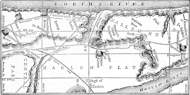
Sketch of Battle-Field, Harlem Heights.
Showing the relative position of the two hostile armies of Great Britain and America, September 16, 1776. From Lamb’s History of the City of New York, Vol. II, p. 129.
Mrs. Lamb gives a confused account in relation to Major Morris’ letter, but this is evidently an oversight, if taken in connection with her full account of the battle. So fully does she consider every authority in locating the site of Harlem Heights, and her deductions are so in accord with my position, that it is unnecessary for me to take further exceptions to other inaccurate statements made by these gentlemen. In conclusion, I will state that under the circumstances I feel that their prologue written as a warning to the public, as to the accuracy of my statement, is, to say the least, uncalled for.
Thos. Addis Emmet, M. D.
(I omitted to correct a misstatement at the beginning of the paper by these gentlemen: My article was written for the Evening Post last winter, while I was South, and in answer to an editorial which had appeared shortly before, but that paper declined to publish it. The editor probably labored under the impression that Messrs. Hall and Bolton knew all about it; and that the buckwheat field could not have been anywhere else but in the grounds of Columbia University, while in fact the real buckwheat field was situated far to the north, near the real Day’s tavern.)