Chapter I
Reading edition
PRELIMINARY REMARKS.—SYMBOLICAL REPRESENTATIONS AND HIEROGLYPHICS, ONE OF THE EARLIEST OBSERVED TRAITS IN THE CUSTOMS AND ARTS OF THE AMERICAN ABORIGINES; BUT THIS ART NOT SUSPECTED TO HAVE A SYSTEMATIC FORM AMONG THE RUDE HUNTER TRIBES OF NORTH AMERICA, UNTIL THE YEAR 1820, WHEN IT WAS DISCOVERED ON THE SOURCE OF THE MISSISSIPPI. THIS INSTANCE GIVEN, WITH A DRAWING: THE HINT PURSUED.
The practice of the North American tribes, of drawing figures and pictures on skins, trees, and various other substances, has been noticed by travellers and writers from the earliest times. Among the more northerly tribes, these figures are often observed on that common substitute for the ancient papyrus, among these nations, the bark of the betula papyracea, or white birch: a substance possessing a smooth surface, easily impressed, very flexible, and capable of being preserved in rolls. Often these devices are cut, or drawn in colours on the trunks of trees, more rarely on rocks or boulders. According to Colden and Lafitou records of this rude character were formerly to be seen on the blazed surface of trees, along some of the ancient paths and portages leading from the sources of the Atlantic rivers into the interior, or in the valley of the St. Lawrence; but these, after satisfying a transient curiosity, have long since yielded to the general fate of these simple and unenduring monuments. Pictures and symbols of this kind are now to be found only on the unreclaimed borders of the great area west of the Alleghanies and the Lakes, in the wide prairies of the west, or along the Missouri and the upper Mississippi. It is known that such devices were in use, to some extent, at the era of the discovery, among most of the tribes, situated between the latitudes of the capes of Florida, and Hudson's Bay, although they have been considered as more particularly characteristic of the tribes of the Algonquin type. In a few instances, these pictorial inscriptions have been found to be painted or stained on the faces of rocks, or on loose boulders, and still more rarely, devices were scratched or pecked into the surface, as is found to be the case still at Dighton and Venango. Those who are intent on observations of this kind, will find figures and rude hieroglyphics invariably at the present time, on the grave posts which mark the places of Indian sepulchre at the west and north. The nations who rove over the western prairies, inscribe them on the skins of the buffalo. North of latitude 42°, the bark of the birch, which furnishes at once the material of canoes, tents, boxes, water-dippers, and paper, constitutes the common medium of their exhibition. Tablets of hard wood are confined to such devices as are employed by their priests and prophets, and medicine men; and these characters uniformly assume a more mystical or sacred import. But the recent discovery, on one of the tributaries of the Susquehanna, of an Indian map, drawn on stone, with intermixed devices, a copy of which appears in the 1st volume of the collections of the Historical Committee of the American Philosophical Society, proves that stone was also employed in that branch of inscription. This discovery was on the area occupied by the Lenapees.
Colden, in his history of the Five Nations,[23] informs us that when, in 1696, the Count de Frontenac marched a well appointed army into the Iroquois country, with artillery and all other means of regular military offence, he found, on the banks of the Onondaga, now called Oswego river, a tree, on the trunk of which the Indians had depicted the French army, and deposited two bundles of cut rushes at its foot, consisting of 1434 pieces—an act of defiance on their part, which was intended to inform their invaders, that they would have to encounter this number of warriors. In speaking in another passage of the general traits of the Five Nations, he mentions the general custom prevalent among the Mohawks going to war, of painting, with red paint, on the trunk of a tree, such symbols, as might serve to denote the object of their expedition. Among the devices was a canoe pointed towards the enemies' country. On their return, it was their practice to visit the same tree, or precinct, and denote the result: the canoe being, in this case, drawn with its bows in the opposite direction. Lafitou, in his account of the nations of Canada, makes observations on this subject to which we shall more particularly refer hereafter, which denote the general prevalence of the custom in that quarter. Other writers, dating as far back as Smith and de Bre, bear a passing testimony to the existence of this trait among the northern tribes. Few have however done more than notice it, and none are known to have furnished any amount of connected details.
A single element in the system attracted early notice. I allude to the institution of the Totem, which has been well known among the Algonquin tribes from the settlement of Canada. By this device, the early missionaries observed, that the natives marked their division of a tribe into clans, and of a clan into families, and the distinction was thus very clearly preserved. Affinities were denoted and kept up, long after tradition had failed in its testimony. This distinction, which is marked with much of the certainty of heraldic bearings in the feudal system, was seen to mark the arms, the lodge, and the trophies of the chief and warrior. It was likewise employed to give identity to the clan of which he was a member, on his ad-je-da-teg or grave-post. This record went but little farther; a few strokes or geometric devices were drawn on these simple monuments, to denote the number of men he had slain in battle.
It has not been suspected in any notices to which I have had access, that there was a pictorial alphabet, or a series of homophonous figures, in which, by the juxtaposition of symbols representing acts, as well as objects of action, and by the introduction of simple adjunct signs, a series of disjunctive, yet generally connected ideas, were denoted; or that the most prominent incidents of life and death could be recorded so as to be transmitted from one generation to another, as long at least as the monument and the people endured. Above all, it was not anticipated that there should have been found, as will be observed in the subsequent details, a system of symbolic notation for the songs and incantations of the Indian metas and priests, making an appeal to the memory for the preservation of language.
Persons familiar with the state of the western tribes of this continent, particularly in the higher northern latitudes, have long been aware that the songs of the Indian priesthood, and wabenoes, were sung from a kind of pictorial notation, made on bark. It is a fact which has often come to the observation of military officers performing duties on those frontiers, and of persons exercising occasional duties in civil life, who have passed through their territories. But there is no class of persons to whom the fact of such notations being made, is so well known, as the class of Indian traders and interpreters who visit or reside a part of the season at the Indian villages. I have never conversed with any of this latter class of persons to whom the fact of such inscriptions, made in various ways, was not so familiar as in their view to excite no surprise or even demand remark.
My attention was first called to the subject in 1820. In the summer of that year I was on an exploring journey through the lake country. At the mouth of the small river Huron, on the banks of Lake Superior, there was an Indian grave fenced around with saplings, and protected with much care. At its head stood a post, or tabular stick, upon which was drawn the figure of the animal which was the symbol of the clan to which the deceased chief belonged. Strokes of red paint were added to denote, either the number of war parties in which he had been engaged, or the number of scalps which he had actually taken from the enemy. The interpreter who accompanied us, and who was himself tinctured with Indian blood, gave the latter, as the true import of these marks.
On quitting the river St. Louis, which flows into the head of the lake at the Fond du Lac, to cross the summit dividing its waters from those of the Mississippi, the way led through heavy and dense woods and swamps, and the weather proved dark and rainy, so that, for a couple of days together, we had scarcely a glimpse of the sun.
The party consisted of sixteen persons, with two Indian guides; but the latter, with all their adroitness in threading the maze, were completely at fault for nearly an entire day. At night we lay down on ground elevated but a few inches above the level of the swamp. The next morning as we prepared to leave the camp, a small sheet of birch bark containing devices was observed elevated on the top of a sapling, some 8 or 10 feet high. One end of this pole was thrust firmly into the ground leaning in the direction we were to go. On going up to this object, it was found, with the aid of the interpreter, to be a symbolic record of the circumstances of our crossing this summit, and of the night's encampment at this spot. Each person was appropriately depicted, distinguishing the soldiers from the officer in command, and the latter from the scavans of the party. The Indians themselves were depicted without hats, this being, as we noticed, the general symbol for a white man or European. The entire record, of which a figure is annexed, accurately symbolized the circumstances, and they were so clearly drawn, according to their conventional rules, that the intelligence would be communicated thereby to any of their people who might chance to travel or wander this way. This was the object of the inscription.
PICTURE WRITING
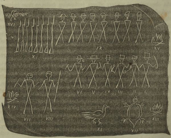
Fig. No. 1. represents the subaltern officer in command of the party of the U.S. troops. He is drawn with a sword to denote his official rank. No. 2 denotes the person who officiated in quality of Secretary. He is represented holding a book. No. 3 denotes the geologist and mineralogist of the party. He is drawn with a hammer. Nos. 4 and 5 are attachés; No. 6, the interpreter.
The group of figures marked 9 represents eight infantry soldiers, each of whom, as shown in group No. 10, was armed with a musket. No. 15 denotes that they had a separate fire, and constituted a separate mess. Figures 7 and 8 are the two Chippewa guides, the principal of whom, called Chamees, or the Pouncing-hawk, led the way over this dreary summit. These are the only human figures on this unique bark letter, who are drawn without a hat. This was the characteristic seized on, by them, and generally employed by the tribes, to distinguish the Red from the white race. Figures 11 and 12 represent a prairie hen, and a green tortoise, which constituted the sum of the preceding day's chase, and were eaten at the encampment. The inclination of the pole, was designed to show the course pursued from that particular spot: there were three hacks in it, below the scroll of bark, to indicate the estimated length of this part of the journey, computing from water to water, that is to say, from the head of the portage Aux Couteaux on the St. Louis river, to the open shores of Sandy lake, the Ka-ma-ton-go-gom-ag of the Odjibwas.
The story was thus briefly and simply told; and this memorial was set up by the guides, to advertise any of their countrymen, who might chance to wander in that direction, of the adventure—for it was evident, both from this token, and from the dubiousness which had marked the prior day's wanderings, that they regarded the passage in this light, and were willing to take some credit for the successful execution of it.
Before we had penetrated quite to this summit, we came to another evidence of their skill in this species of knowledge, consisting of one of those contrivances which they denominate Man-i-to-wa-teg, or Manito Poles. On reaching this our guides shouted, whether from a superstitious impulse, or the joy of having found a spot they certainly could recognize, we could not tell. We judged the latter. It consisted of eight poles, of equal length, shaved smooth and round, painted with yellow ochre, and set so as to enclose a square area. It appeared to have been one of those rude temples, or places of incantation or worship, known to the metas, or priests, where certain rites and ceremonies are performed. But it was not an ordinary medicine lodge. There had been far more care in its construction.
On reaching the village of Sandy lake, on the upper Mississippi, the figures of animals, birds, and other devices were found, on the rude coffins, or wrappings of their dead, which were scaffolded around the precincts of the fort, and upon the open shores of the lake. Similar devices were also observed, here, as at other points in this region, upon their arms, war-clubs, canoes, and other pieces of moveable property, as well as upon their grave posts.
In the descent of the Mississippi, we observed such devices painted on a rock, below and near the mouth of Elk river, and at a rocky island in the river, at the Little Falls. In the course of our descent to the Falls at St. Anthony, we observed another bark letter, as the party now began to call these inscriptions, suspended on a high pole, on an elevated bank of the river, on its west shore. At this spot, where we encamped for the night, and which is just opposite a point of highly crystalized hornblende rock, called the Peace Rock, rising up through the prairie, there were left standing the poles or skeletons of a great number of Sioux lodges. It is near and a little west of the territorial boundary of the Sioux nation; and on inspecting this scroll of bark, we found it had reference to a negotiation for bringing about a permanent peace between the Sioux and Chippewas. A large party of the former, from St. Peter's, headed by their chief, had proceeded thus far, in the hope of meeting the Chippewa hunters, on their summer hunt. They had been countenanced, or directed in this step, by Col. Leavenworth, the commanding officer of the new post, just then about to be erected. The inscription, which was read off at once, by the Chippewa Chief Babesacundabee, who was with us, told all this; it gave the name of the Chief who had led the party, and the number of his followers, and gave that chief the first assurance he had, that his mission for the same purpose, would be favourably received.
After our arrival at St. Anthony's Falls, it was found that this system of picture writing was as familiar to the Dacotah, as we had found it among the Algonquin race. At Prairie du Chien, and at Green Bay, the same evidences were observed among the Monomonees, and the Winnebagoes, at Chicago among the Pottowottomies, and at Michilimakinac, among the Chippewas and Ottawas who resort, in such numbers, to that Island. While at the latter place, on my return, I went to visit the grave of a noted chief of the Monomonee tribe, who had been known by his French name of Toma, i.e. Thomas. He had been buried on the hill west of the village; and on looking at his Ad-je-da-tig or grave post, it bore a pictorial inscription, commemorating some of the prominent achievements of his life.
These hints served to direct my attention to the subject when I returned to the country in 1822. The figures of a deer, a bear, a turtle, and a crane, according to this system, stand respectively for the names of men, and preserve the language very well, by yielding to the person conversant with it, the corresponding words, of Addick, Muckwa, Mickenock, and Adjeejauk. Marks, circles, or dots, of various kinds, may symbolize the number of warlike deeds. Adjunct devices may typify or explain adjunct acts. If the system went no farther, the record would yield a kind of information both gratifying and useful to one of his countrymen who had no letters and was expert in the use of symbols; and the interpretation of it, would be easy and precise in proportion as the signs were general, conventional, and well understood. There was abundant evidence in my first year's observation, to denote that this mode of communication was in vogue, and well understood by the northern tribes; but it hardly seemed susceptible of a farther or extended use. It was not till I had made a personal acquaintance with one of their Metas—a man of much intelligence, and well versed in their customs, religion, and history, that a more enlarged application of it appeared to be practicable. I observed in the hands of this man a tabular piece of wood, covered over on both sides, with a series of devices cut between parallel lines, which he referred to, as if they were the notes of his medicine and mystical songs. I heard him sing these songs, and observed that their succession was fixed and uniform. By cultivating his acquaintance, and by suitable attention and presents, such as the occasion rendered proper, he consented to explain the meaning of each figure, the object symbolized, and the words attached to each symbol. By this revelation, which was made with closed doors, I became a member or initiate of the Medicine Society, and also of the Wabeno Society. Care was taken to write each sentence of the songs and chants in the Indian language, with its appropriate devices, and to subjoin a literal translation in English. When this had been done, and the system considered, it was very clear that the devices were mnemonic—that any person could sing from these devices, very accurately, what he had previously committed to memory, and that the system revealed a curious scheme of symbolic notation.
All the figures thus employed, as the initiatory points of study, related exclusively to either the medicine dance, or the wabeno dance; and each section of figures, related exclusively to one or the other. There was no intermixture or commingling of characters, although the class of subjects were sometimes common to each. It was perceived, subsequently, that this classification of symbols extended to the songs devoted to war, to hunting, and to other specific topics. The entire inscriptive system, reaching from its first rudimental characters, in the ad-je-da-tig, or grave board, to the extended roll of bark covered with the inscriptions of their magicians and prophets, derived a new interest from this feature. It was easy to perceive that much comparative precision was imparted to interpretations in the hands of the initiated, which before, or to others, had very little. An interest was thus cast over it distinct from its novelty. And in truth, the entire pictorial system was thus invested with the character of a subject of accurate investigation, which promised both interest and instruction.
It has been thought that a simple statement of these circumstances, would best answer the end in view, and might well occupy the place of a more formal or profound introduction. In bringing forward the elements of the system, after much reflection, it is thought, however, that a few remarks on the general character of this art may not be out of place. For, simple as it is, we perceive in it the native succedaneum for letters. It is not only the sole graphic mode they have for communicating ideas, but it is the mode of communicating all classes of ideas commonly entertained by them—such as their ideas of war, of hunting, of religion, and of magic and necromancy. So considered, it reveals a new and unsuspected mode of obtaining light on their opinions of a deity, of the structure or cosmogony of the globe, of astronomy, the various classes of natural objects, their ideas of immortality and a future state, and the prevalent notions of the union of spiritual and material matter. So wide and varied, indeed, is the range opened by the subject, that we may consider the Indian system of picture writing as the thread which ties up the scroll of the Red man's views of life and death, reveals the true theory of his hopes and fears, and denotes the relation he bears, in the secret chambers of his own thoughts, to his Maker. What a stoic and suspicious temper would often hold him back from uttering to another, and what a limited language would sometimes prevent his fully revealing, if he wished, symbols and figures can be made to represent and express. The Indian is not a man prone to describe his god, but he is ready to depict him, by a symbol. He may conceal under the figures of a serpent, a turtle, or a wolf, wisdom, strength, or malignity, or convey under the picture of the sun, the idea of a supreme, all-seeing intelligence. But he is not prepared to discourse upon these things. What he believes on this head, he will not declare to a white man or a stranger. His happiness and success in life, are thought to depend upon the secrecy of that knowledge of the Creator and his system in the Indian view of benign and malignant agents. To reveal this to others, even to his own people, is, he believes, to expose himself to the counteracting influence of other agents known to his subtle scheme of necromancy and superstition, and to hazard success and life itself. This conduces to make the Red man eminently a man of fear, suspicion, and secrecy. But he cannot avoid some of these disclosures in his pictures and figures. These figures represent ideas—whole ideas, and their juxtaposition or relation on a roll of bark, a tree, or a rock, discloses a continuity of ideas. This is the basis of the system.
Picture writing is indeed the literature of the Indians. It cannot be interpreted, however rudely, without letting one know what the Red man thinks and believes. It shadows forth the Indian intellect, it stands in the place of letters for the Unishinaba.[24] It shows the Red man in all periods of our history, both as he was, and as he is; for there is nothing more true than that, save and except the comparatively few instances where they have truly embraced experimental Christianity, there has not
[Transcriber's Note: Text ends abruptly here in the original publication.]
GRAVE CREEK MOUND.
This gigantic tumulus, the largest in the Ohio valley, was opened some four or five years ago, and found to contain some articles of high antiquarian value, in addition to the ordinary discoveries of human bones, &c. A rotunda was built under its centre, walled with brick, and roofed over, and having a long gallery leading into it, at the base of the mound. Around this circular wall, in the centre of this heavy and damp mass of earth, with its atmosphere of peculiar and pungent character, the skeletons and other disinterred articles, are hung up for the gratification of visiters, the whole lighted up with candles, which have the effect to give a strikingly sepulchral air to the whole scene. But what adds most to this effect, is a kind of exuded flaky matter, very white and soft, and rendered brilliant by dependent drops of water, which hangs in rude festoons from the ceiling.
To this rotunda, it is said, a delegation of Indians paid a visit a year or two since. In the "Wheeling Times and Advertiser" of the 30th August 1843, the following communication, respecting this visit, introducing a short dramatic poem, was published.
"An aged Cherokee chief who, on his way to the west, visited the rotunda excavated in this gigantic tumulus, with its skeletons and other relics arranged around the walls, became so indignant at the desecration and display of sepulchral secrets to the white race, that his companions and interpreter found it difficult to restrain him from assassinating the guide. His language assumed the tone of fury, and he brandished his knife, as they forced him out of the passage. Soon after, he was found prostrated, with his senses steeped in the influence of alcohol.
"'Tis not enough! that hated race Should hunt us out, from grove and place And consecrated shore—where long Our fathers raised the lance and song— 'Tis not enough!—that we must go Where streams and rushing fountains flow Whose murmurs, heard amid our fears, Fall only on a stranger's ears— 'Tis not enough!—that with a wand, They sweep away our pleasant land, And bid us, as some giant-foe, Or willing, or unwilling go! But they must ope our very graves To tell the dead—they too, are slaves."
NAMES OF THE AMERICAN LAKES.
Ontario, is a word from the Wyandot, or, as called by the Iroquois, Quatoghie language. This tribe, prior to the outbreak of the war against them, by their kindred the Iroquois, lived on a bay, near Kingston, which was the ancient point of embarkation and debarkation, or, in other words, at once the commencement and the terminus of the portage, according to the point of destination for all, who passed into or out of the lake. From such a point it was natural that a term so euphonous, should prevail among Europeans, over the other Indian names in use. The Mohawks and their confederates, generally, called it Cadaracqui—which was also their name for the St. Lawrence. The Onondagas, it is believed, knew it, in early times, by the name of Oswego.[25] Of the meaning of Ontario, we are left in the dark by commentators on the Indian. Philology casts some light on the subject. The first syllable, on, it may be observed, appears to be the notarial increment or syllable of Onondio, a hill. Tarak, is clearly, the same phrase, written darac, by the French, in the Mohawk compound of Cadaracqui; and denotes rocks, i. e. rocks standing in the water. In the final vowels io, we have the same term, with the same meaning which they carry in the Seneca, or old Mingo word Ohio.[26] It is descriptive of an extended and beautiful water prospect, or landscape. It possesses all the properties of an exclamation, in other languages, but according to the unique principles of the Indian grammar, it is an exclamation-substantive. How beautiful! [the prospect, scene present.]
Erie is the name of a tribe conquered or extinguished by the Iroquois. We cannot stop to inquire into this fact historically, farther than to say, that it was the policy of this people to adopt into their different tribes of the confederacy, the remnants of nations whom they conquered, and that it was not probable, therefore, that the Eries were annihilated. Nor is it probable that they were a people very remote in kindred and language from the ancient Sinondowans, or Senecas, who, it may be supposed, by crushing them, destroyed and exterminated their name only, while they strengthened their numbers by this inter-adoption. In many old maps, this lake bears the name of Erie or "Oskwago."
Huron, is the nom de guerre of the French, for the "Yendats," as they are called in some old authors, or the Wyandots. Charlevoix tells us that it is a term derived from the French word hure, [a wild boar,] and was applied to this nation from the mode of wearing their hair. "Quelles Hures!" said the first visiters, when they saw them, and hence, according to this respectable author, the word Huron.
When this nation, with their confederates, the Algonquins, or Adirondaks, as the Iroquois called them, were overthrown in several decisive battles on the St. Lawrence, between Montreal and Quebec, and compelled to fly west; they at first took shelter in this lake, and thus transferred their name to it. With them, or at least, at the same general era, came some others of the tribes who made a part of the people called by the French, Algonquins, or Nipercineans, and who thus constituted the several tribes, speaking a closely cognate language, whose descendants are regarded by philologists, as the modern Lake-Algonquins.
The French sometimes called this lake Mer douce, or the Placid sea. The Odjibwas and some other northern tribes of that stock, call it Ottowa lake. No term has been found for it in the Iroquois language, unless it be that by which they distinguished its principal seat of trade, negociation and early rendezvous, the island of Michilimackinac, which they called Tiedonderaghie.
Michigan is a derivative from two Odjibwa-Algonquin words, signifying large, i.e. large in relation to masses in the inorganic kingdom, and a lake. The French called it, generally, during the earlier periods of their transactions, the lake of the Illinese, or Illinois.
Superior, the most northwesterly, and the largest of the series, is a term which appears to have come into general use, at a comparatively early era, after the planting of the English colonies. The French bestowed upon it, unsuccessfully, one or two names, the last of which was Traci, after the French minister of this name. By the Odjibwa-Algonquins, who at the period of the French discovery, and who still occupy its borders, it is called Gitch-Igomee, or The Big Sea-water; from Gitchee, great, and guma, a generic term for bodies of water. The term IGOMA, is an abbreviated form of this, suggested for adoption.
The poetry of the Indians, is the poetry of naked thought. They have neither rhyme, nor metre to adorn it.
Tales and traditions occupy the place of books, with the Red Race.—They make up a kind of oral literature, which is resorted to, on long winter evenings, for the amusement of the lodge.
The love of independence is so great with these tribes, that they have never been willing to load their political system with the forms of a regular government, for fear it might prove oppressive.
To be governed and to be enslaved, are ideas which have been confounded by the Indians.
GEOGRAPHICAL TERMINOLOGY OF THE U. STATES,
DERIVED FROM THE INDIAN LANGUAGE.
These Extracts are made from "Cyclopædia Indiaensis" a MS. work in preparation. No. I.
Hudson River.—By the tribes who inhabited the area of the present County of Dutchess, and other portions of its eastern banks, as low down as Tappan, this river was called Shatemuc—which is believed to be a derivative from Shata, a pelican. The Minisi, who inhabited the west banks, below the point denoted, extending indeed over all the east half of New Jersey, to the falls of the Raritan, where they joined their kindred the Lenni Lenape, or Delawares proper, called it Mohicanittuck—that is to say, River of the Mohicans. The Mohawks, and probably the other branches of the Iroquois, called it Cahohatatea—a term of which the interpreters who have furnished the word, do not give an explanation. The prefixed term Caho, it may be observed, is their name for the lower and principal falls of the Mohawk. Sometimes this prefix was doubled, with the particle ha, thrown in between. Hatatea is clearly one of those descriptive and affirmative phrases representing objects in the vegetable and mineral kingdoms, which admitted as we see, in other instances of their compounds, a very wide range. By some of the more westerly Iroquois, the river was called Sanataty.
Albany.—The name by which this place was known to the Iroquois, at an early day, was Schenectady, a term which, as recently pronounced by a daughter of Brant, yet living in Canada, has the still harsher sound of Skoh-nek-ta-ti, with a stress on the first, and the accent strongly on the second syllable, the third and fourth being pronounced rapidly and short. The transference of this name, to its present location, by the English, on the bestowal on the place by Col. Nichols, of a new name, derived from the Duke of York's Scottish title, is well known, and is stated, with some connected traditions, by Judge Benson, in his eccentric memoir before the New York Historical Society. The meaning of this name, as derived from the authority above quoted, is Beyond the Pines, having been applied exclusively in ancient times, to the southern end of the ancient portage path, from the Mohawk to the Hudson. By the Minci, who did not live here, but extended, however, on the west shore above Coxackie, and even Coeymans, it appears to have been called Gaishtinic. The Mohegans, who long continued to occupy the present area of Rensselaer and Columbia counties, called it Pempotawuthut, that is to say, the City or Place of the Council Fire. None of these terms appear to have found favour with the European settlers, and, together with their prior names of Beaverwyck and Fort Orange, they at once gave way, in 1664, to the present name. A once noted eminence, three miles west, on the plains, i.e. Trader's Hill, was called Isutchera, or by prefixing the name for a hill, Yonondio Isutchera. It means the hill of oil. Norman's Kill, which enters the Hudson a little below, the Mohawks called Towasentha, a term which is translated by Dr. Yates, to mean, a place of many dead.
Niagara.—It is not in unison, perhaps, with general expectation, to find that the exact translation of this name does not entirely fulfil poetic preconception. By the term O-ne-aw-ga-ra, the Mohawks and their co-tribes described on the return of their war excursions, the neck of water which connects lake Erie with Ontario. The term is derived from their name for the human neck. Whether this term was designed to have, as many of their names do, a symbolic import, and to denote the importance of this communication in geography, as connecting the head and heart of the country, can only be conjectured. Nor is it, in this instance, probable. When Europeans came to see the gigantic falls which marked the strait, it was natural that they should have supposed the name descriptive of that particular feature, rather than the entire river and portage. We have been assured, however, that it is not their original name for the water-fall, although with them, as with us, it may have absorbed this meaning.
Buffalo.—The name of this place in the Seneca, is Te-ho-sa-ro-ro. Its import is not stated.
Detroit.—By the Wyandots, this place is called Teuchsagrondie; by the Lake tribes of the Algic type, Wa-we-á-tun-ong: both terms signify the Place of the turning or Turned Channel. It has been remarked by visiters who reach this place at night, or in dark weather, or are otherwise inattentive to the courses, that owing to the extraordinary involutions of the current the sun appears to rise in the wrong place.
Chicago.—This name, in the Lake Algonquin dialects, to preserve the same mode of orthography, is derived from Chicagowunzh, the wild onion or leek. The orthography is French, as they were the discoverers and early settlers of this part of the west. Kaug, in these dialects is a porcupine, and She kaug a polecat. The analogies in these words are apparent, but whether the onion was named before or after the animal, must be judged if the age of the derivation be sought for.
Tuscaloosa, a river of Alabama. From the Chacta words tushka, a warrior, and lusa black.—[Gallatin.]
Aragiske, the Iroquois name for Virginia.
Assarigoa, the name of the Six Nations for the Governor of Virginia.
Owenagungas, a general name of the Iroquois for the New England Indians.
Oteseonteo, a spring which is the head of the river Delaware.
Ontonagon, a considerable river of lake Superior, noted from early times, for the large mass of native copper found on its banks. This name is said to have been derived from the following incident. It is known that there is a small bay and dead water for some distance within its mouth. In and out of this embayed water, the lake alternately flows, according to the influence of the winds, and other causes, upon its level. An Indian woman had left her wooden dish, or Onagon, on the sands, at the shore of this little bay, where she had been engaged. On coming back from her lodge, the outflowing current had carried off her valued utensil. Nia Nin-do-nau-gon! she exclaimed, for it was a curious piece of workmanship. That is to say—Alas! my dish!
Chuah-nah-whah-hah, or Valley of the Mountains. A new pass in the Rocky Mountains, discovered within a few years. It is supposed to be in N. latitude about 40°. The western end of the valley gap is 30 miles wide, which narrows to 20 at its eastern termination, it then turns oblique to the north, and the opposing sides appear to close the pass, yet there is a narrow way quite to the foot of the mountain. On the summit there is a large beaver pond, which has outlets both ways, but the eastern stream dries early in the season, while there is a continuous flow of water west. In its course, it has several beautiful, but low cascades, and terminates in a placid and delightful stream. This pass is now used by emigrants.
Aquidneck.—The Narragansett name for Rhode Island. Roger Williams observes, that he could never obtain the meaning of it from the natives. The Dutch, as appears by a map of Novi Belgii published at Amsterdam in 1659, called it Roode Eylant, or Red Island, from the autumnal colour of its foliage. The present term, as is noticed, in Vol. III. of the Collections of the R.I. Hist. Soc. is derived from this.
Incapatchow, a beautiful lake in the mountains at the sources of the river Hudson.—[Charles F. Hoffman, Esq.]
Housatonic, a river originating in the south-western part of Massachusetts, and flowing through the State of Connecticut into Long Island Sound, at Stratford. It is a term of Mohegan origin. This tribe on retiring eastward from the banks of the Hudson, passed over the High-lands, into this inviting valley. We have no transmitted etymology of the term, and must rely on the general principles of their vocabulary. It appears to have been called the valley of the stream beyond the Mountains, from ou, the notarial sign of wudjo, a mountain, atun, a generic phrase for stream or channel, and ic, the inflection for locality.
Wea-nud-nec.—The Indian name, as furnished by Mr. O'Sullivan, [D. Rev.] for Saddle Mountain, Massachusetts. It appears to be a derivative from Wa-we-a, round, i. e. any thing round or crooked, in the inanimate creation.
Ma-hai-we.—The Mohegan term, as given by Mr. Bryant [N.Y.E.P.] for Great Barrington, Berkshire County, Massachusetts.
Massachusetts.—This was not the name of a particular tribe, but a geographical term applied, it should seem, to that part of the shores of the North Atlantic, which is swept by the tide setting into, and around the peninsula of Cape Cod, and the wide range of coast trending southerly. It became a generic word, at an early day, for the tribes who inhabited this coast. It is said to be a word of Narragansett origin, and to signify the Blue Hills. This is the account given of it by Roger Williams, who was told, by the Indians, that it had its origin from the appearance of an island off the coast. It would be more in conformity to the general requisitions of ethnography, to denominate the language the New England-Algonquin, for there are such great resemblances in the vocabulary and such an identity in grammatical construction, in these tribes, that we are constantly in danger, by partial conclusions as to original supremacy, of doing injustice. The source of origin was doubtless west and south west, but we cannot stop at the Narragansetts, who were themselves derivative from tribes still farther south. The general meaning given by Williams seems, however, to be sustained, so far as can now be judged. The terminations in ett, and set, as well as those in at and ak, denoted locality in these various tribes. We see also, in the antipenultimate Chu, the root of Wudjo, a mountain.
Ta-ha-wus, a very commanding elevation, several thousand feet above the sea, which has of late years, been discovered at the sources of the Hudson, and named Mount Marcy. It signifies, he splits the sky.—[Charles F. Hoffman, Esq.]
Mong, the name of a distinguished chief of New England, as it appears to be recorded in the ancient pictorial inscription on the Dighton Rock, in Massachusetts, who flourished before the country was colonized by the English. He was both a war captain, and a prophet, and employed the arts of the latter office, to increase his power and influence, in the former. By patient application of his ceremonial arts, he secured the confidence of a large body of men, who were led on, in the attack on his enemies, by a man named Piz-hu. In this onset, it is claimed that he killed forty men, and lost three. To the warrior who should be successful, in this enterprize, he had promised his younger sister. [Such are the leading events symbolized by this inscription, of which extracts giving full details, as interpreted by an Indian chief, now living, and read before the Am. Ethnological Society, in 1843, will be furnished, in a subsequent number.]
Tioga.—A stream, and a county of the State of New-York. From Teoga, a swift current, exciting admiration.
Dionderoga, an ancient name of the Mohawk tribe, for the site at the mouth of the Schoharie creek, where Fort Hunter was afterwards built [Col. W.L. Stone.]
Almouchico, a generic name of the Indians for New England, as printed on the Amsterdam map of 1659, in which it is stated that it was thus "by d inwoonders genaemt." (So named by the natives.)
Irocoisia, a name bestowed in the map, above quoted, on that portion of the present state of Vermont, which lies west of the Green Mountains, stretching along the eastern bank of Lake Champlain. By the application of the word, it is perceived that the French were not alone in the use they made of the apparently derivative term "Iroquois," which they gave to the (then) Five Nations.
NAMES OF THE SEASONS.
The following are the names of the four seasons, in the Odjibwa tongue:
Pe-bon,Winter,FromKone,Snow.
Se-gwun,Spring,"Seeg,Running water.
Ne-bin,Summer,"Anib,A leaf.
Ta-gwá-gi,Autumn,"Gwag,The radix of behind &c.
By adding the letter g to these terms, they are placed in the relation of verbs in the future tense, but a limited future, and the terms then denote next winter, &c. Years, in their account of time, are counted by winters. There is no other term, but pe-boan, for a year. The year consists of twelve lunar months, or moons. A moon is called Geézis, or when spoken of in contradistinction to the sun, Dibik Geézis, or night-sun.
The cardinal points are as follows.
(a)North,Ke wá din-ung.
(b)South,O shá wan-ung.
(c)East,Wá bun-ung.
(d)West,Ká be un-ung.
a. Kewadin is a compound derived from Ke-wa, to return, or come home, and nodin, the wind. b. Oshauw is, from a root not apparent, but which produces also ozau, yellow, &c. c. Waban is from ab, or wab, light. d. Kabeun, is the name of a mythological person, who is spoken of, in their fictions, as the father of the winds. The inflection ung, or oong, in each term, denotes course, place, or locality.
LETTERS ON THE ANTIQUITIES OF THE WESTERN COUNTRY,
THE LATE WILLIAM L. STONE, EDITOR OF THE NEW YORK COMMERCIAL ADVERTISER.
I.
Wheeling (Va.), August 19th, 1843.
I have just accomplished the passage of the Alleghany mountains, in the direction from Baltimore to this place, and must say, that aside from the necessary fatigue of night riding, the pass from the Cumberland mountains and Laurel Hill is one of the easiest and most free from danger of any known to me in this vast range. An excellent railroad now extends from Baltimore, by Frederick and Harper's Ferry, up the Potomac valley and its north branch quite to Cumberland, which is seated just under the mountains, whose peaks would seem to bar all farther approach. The national road finds its way, however, through a gorge, and winds about where "Alps on Alps arise," till the whole vast and broad-backed elevation is passed, and we descend west, over a smooth, well constructed macadamized road, with a velocity which is some compensation for the toil of winding our way up. Uniontown is the first principal place west. The Monongahela is crossed at Brownsville, some forty miles above Pittsburgh, whence the road, which is every where well made and secured with fine stone bridges, culverts and viaducts, winds around a succession of most enchanting hills, till it enters a valley, winds up a few more hills, and brings the travellers out, on the banks of the Ohio, at this town.
The entire distance from the head of the Chesapeake to the waters of the Ohio is not essentially different from three hundred miles. We were less than two days in passing it, twenty-six hours of which, part night and part day, were spent in post-coaches between Cumberland and this place. Harper's Ferry is an impressive scene, but less so than it would be to a tourist who had not his fancy excited by injudicious descriptions. To me, the romance was quite taken away by driving into it with a tremendous clattering power of steam. The geological structure of this section of country, from water to water, is not without an impressive lesson. In rising from the Chesapeake waters the stratified rocks are lifted up, pointing west, or towards the Alleghanies, and after crossing the summit they point east, or directly contrary, like the two sides of the roof of a house, and leave the inevitable conclusion that the Alleghanies have been lifted up by a lateral rent, as it were, at the relative point of the ridge pole. It is in this way that the granites and their congeners have been raised up into their present elevations.
I did not see any evidence of that wave-like or undulatory structure, which was brought forward as a theory last year, in an able paper forwarded by Professor Rogers, and read at the meeting of the British Association for the Advancement of Science at Manchester. No organic remains are, of course, visible, in this particular section, at least until we strike the coal and iron-stone formation of Pittsburgh. But I have been renewedly impressed with the opinion, so very opposite to the present geological theory, that less than seven thousand years is sufficient, on scientific principles, to account for all the phenomena of fossil plants, shells, bones and organic remains, as well as the displacements, disruptions, subsidences and rising of strata, and other evidences of extensive physical changes and disturbances on the earth's surface. And I hope to live to see some American geologist build up a theory on just philosophical and scientific principles, which shall bear the test of truth.
But you will, perhaps, be ready to think that I have felt more interest in the impressions of plants in stone, than is to be found in the field of waving corn before the eye. I have, however, by no means neglected the latter; and can assure you that the crops of corn, wheat and other grains, throughout Maryland, Pennsylvania and Western Virginia, are excellent. Even the highest valleys in the Alleghanies are covered with crops of corn, or fields of stacked wheat and other grains. Generally, the soil west of the mountains is more fertile. The influence of the great western limestones, as one of its original materials, and of the oxide of iron, is clearly denoted in heavier and more thrifty cornfields along the Monongahela and Ohio valleys.
Of the Ohio River itself, one who had seen it in its full flow, in April and May, would hardly recognize it now. Shrunk in a volume far below its noble banks, with long spits of sand and gravel running almost across it, and level sandy margins, once covered by water, where armies might now manœuvre, it is but the skeleton of itself. Steamboats of a hundred tons burden now scarcely creep along its channel, which would form cockboats for the floating palaces to be seen here in the days of its vernal and autumnal glory.
Truly yours,
HENRY R. COLCRAFT
II.
Grave Creek Flats (Va.), August 23, 1843.
I have devoted several days to the examination of the antiquities of this place and its vicinity, and find them to be of even more interest than was anticipated. The most prominent object of curiosity is the great tumulus, of which notices have appeared in western papers; but this heavy structure of earth is not isolated. It is but one of a series of mounds and other evidences of ancient occupation at this point, of more than ordinary interest. I have visited and examined seven mounds, situated within a short distance of each other. They occupy the summit level of a rich alluvial plain, stretching on the left or Virginia bank of the Ohio, between the junctions of Big and Little Grave Creeks with that stream. They appear to have been connected by low earthen entrenchments, of which plain traces are still visible on some parts of the commons. They included a well, stoned up in the usual manner, which is now filled with rubbish.
The summit of this plain is probably seventy-five feet above the present summer level of the Ohio. It constitutes the second bench, or rise of land, above the water. It is on this summit, and on one of the most elevated parts of it, that the great tumulus stands. It is in the shape of a broad cone, cut off at the apex, where it is some fifty feet across. This area is quite level, and commands a view of the entire plain, and of the river above and below, and the west shores of the Ohio in front. Any public transaction on this area would be visible to multitudes around it, and it has, in this respect, all the advantages of the Mexican and Yucatanese teocalli. The circumference of the base has been stated at a little under nine hundred feet; the height is sixty-nine feet.
The most interesting object of antiquarian inquiry is a small flat stone, inscribed with antique alphabetic characters, which was disclosed on the opening of the large mound. These characters are in the ancient rock alphabet of sixteen right and acute angled single stokes, used by the Pelasgi and other early Mediterranean nations, and which is the parent of the modern Runic as well as the Bardic. It is now some four or five years since the completion of the excavations, so far as they have been made, and the discovery of this relic. Several copies of it soon got abroad, which differed from each other, and, it was supposed, from the original. This conjecture is true; neither the print published in the Cincinnati Gazette, in 1839, nor that in the American Pioneer, in 1843, is correct. I have terminated this uncertainty by taking copies by a scientific process, which does not leave the lines and figures to the uncertainty of man's pencil.
The existence of this ancient art here could hardly be admitted, otherwise than as an insulated fact, without some corroborative evidence, in habits and customs, which it would be reasonable to look for in the existing ruins of ancient occupancy. It is thought some such testimony has been found. I rode out yesterday three miles back to the range of high hills which encompass this sub-valley, to see a rude tower of stone standing on an elevated point, called Parr's point, which commands a view of the whole plain, and which appears to have been constructed as a watch-tower, or look-out, from which to descry an approaching enemy. It is much dilapidated. About six or seven feet of the work is still entire. It is circular, and composed of rough stones, laid without mortar, or the mark of a hammer. A heavy mass of fallen wall lies around, covering an area of some forty feet in diameter. Two similar points of observation, occupied by dilapidated towers, are represented to exist, one at the prominent summit of the Ohio and Grave Creek hills, and another on the promontory on the opposite side of the Ohio, in Belmont county, Ohio.
It is known to all acquainted with the warlike habits of our Indians, that they never have evinced the foresight to post a regular sentry, and these rude towers may be regarded as of cotemporaneous age with the interment of the inscription.
Several polished tubes of stone have been found, in one of the lesser mounds, the use of which is not very apparent. One of these, now on my table, is 12 inches long, 1-1/4 wide at one end, and 1-1/2 at the other. It is made of a fine, compact, lead blue steatite, mottled, and has been constructed by boring, in the manner of a gun barrel. This boring is continued to within about three-eighths of an inch of the larger end, through which but a small aperture is left. If this small aperture be looked through, objects at a distance are more clearly seen. Whether it had this telescopic use, or others, the degree of art evinced in its construction is far from rude. By inserting a wooden rod and valve, this tube would be converted into a powerful syphon, or syringe.
I have not space to notice one or two additional traits, which serve to awaken new interest at this ancient point of aboriginal and apparently mixed settlement, and must omit them till my next.
III.
Grave Creek Flats, August 24, 1843.
The great mound at these flats was opened as a place of public resort about four years ago. For this purpose a horizontal gallery to its centre was dug and bricked up, and provided with a door. The centre was walled round as a rotunda, of about twenty-five feet diameter, and a shaft sunk from the top to intersect it; it was in these two excavations that the skeletons and accompanying relics and ornaments were found. All these articles are arranged for exhibition in this rotunda, which is lighted up with candles. The lowermost skeleton is almost entire, and in a good state of preservation, and is put up by means of wires, on the walls. It has been overstretched in the process so as to measure six feet; it should be about five feet eight inches. It exhibits a noble frame of the human species, bearing a skull with craniological developments of a highly favorable character. The face bones are elongated, with a long chin and symmetrical jaw, in which a full and fine set of teeth, above and below, are present. The skeletons in the upper vault, where the inscription stone was found, are nearly all destroyed.
It is a damp and gloomy repository, and exhibits in the roof and walls of the rotunda one of the most extraordinary sepulchral displays which the world affords. On casting the eye up to the ceiling, and the heads of the pillars supporting it, it is found to be encrusted, or rather festooned, with a white, soft, flaky mass of matter, which had exuded from the mound above. This apparently animal exudation is as white as snow. It hangs in pendent masses and globular drops; the surface is covered with large globules of clear water, which in the reflected light have all the brilliancy of diamonds. These drops of water trickle to the floor, and occasionally the exuded white matter falls. The wooden pillars are furnished with the appearance of capitals, by this substance. That it is the result of a soil highly charged with particles of matter, arising from the decay or incineration of human bodies, is the only theory by which we may account for the phenomenon. Curious and unique it certainly is, and with the faint light of a few candles it would not require much imagination to invest the entire rotunda with sylph-like forms of the sheeted dead.
An old Cherokee chief, who visited this scene, recently, with his companions, on his way to the West, was so excited and indignant at the desecration of the tumulus, by this display of bones and relics to the gaze of the white race, that he became furious and unmanageable; his friends and interpreters had to force him out, to prevent his assassinating the guide; and soon after he drowned his senses in alcohol.
That this spot was a very ancient point of settlement by the hunter race in the Ohio valley, and that it was inhabited by the present red race of North American Indians, on the arrival of whites west of the Alleghanies, are both admitted facts; nor would the historian and antiquary ever have busied themselves farther in the matter had not the inscribed stone come to light, in the year 1839. I was informed, yesterday, that another inscription stone had been found in one of the smaller mounds on these flats, about five years ago, and have obtained data sufficient as to its present location to put the Ethnological Society on its trace. If, indeed, these inscriptions shall lead us to admit that the continent was visited by Europeans prior to the era of Columbus, it is a question of very high antiquarian interest to determine who the visitors were, and what they have actually left on record in these antique tablets.
I have only time to add a single additional fact. Among the articles found in this cluster of mounds, the greater part are commonplace, in our western mounds and town ruins. I have noticed but one which bears the character of that unique type of architecture found by Mr. Stephens and Mr. Catherwood in Central America and Yucatan. With the valuable monumental standards of comparison furnished by these gentlemen before me, it is impossible not to recognize, in an ornamental stone, found in one of the lesser mounds here, a specimen of similar workmanship. It is in the style of the heavy feather-sculptured ornaments of Yucatan—the material being a wax yellow sand-stone, darkened by time. I have taken such notes and drawings of the objects above referred to, as will enable me, I trust, in due time, to give a connected account of them to our incipient society.
IV.
Massillon, Ohio, August 27th, 1843.
Since my last letter I have traversed the State of Ohio, by stage, to this place. In coming up the Virginia banks of the Ohio from Moundsville, I passed a monument, of simple construction, erected to the memory of a Captain Furman and twenty-one men, who were killed by the Indians, in 1777, at that spot. They had been out, from the fort at Wheeling, on a scouting party, and were waylaid at a pass called the narrows. The Indians had dropped a pipe and some trinkets in the path, knowing that the white men would pick them up, and look at them, and while the latter were grouped together in this act, they fired and killed every man. The Indians certainly fought hard for the possession of this valley, aiming, at all times, to make up by stratagem what they lacked in numbers. I doubt whether there is in the history of the spread of civilisation over the world a theatre so rife with partisan adventure, massacre and murder, as the valley of the Ohio and the country west of the Alleghany generally presented between the breaking out of the American revolution, in '76, and the close of the Black Hawk war in 1832. The true era, in fact, begins with the French war, in 1744, and terminates with the Florida war, the present year. A work on this subject, drawn from authentic sources, and written with spirit and talent, would be read with avidity and possess a permanent interest.
The face of the country, from the Ohio opposite Wheeling to the waters of the Tuscarawas, the north fork of the Muskingum, is a series of high rolling ridges and knolls, up and down which the stage travels slowly. Yet this section is fertile and well cultivated in wheat and corn, particularly the latter, which looks well. This land cannot be purchased under forty or fifty dollars an acre. Much of it was originally bought for seventy-five cents per acre. It was over this high, wavy land, that the old Moravian missionary road to Gnadenhutten ran, and I pursued it to within six miles of the latter place. You will recollect this locality as the scene of the infamous murder, by Williamson and his party, of the non-resisting Christian Delawares under the ministry of Heckewelder and Ziesberger.
On the Stillwater, a branch of the Tuscarawas, we first come to level lands. This stream was noted, in early days, for its beaver and other furs. The last beaver seen here was shot on its banks twelve years ago. It had three legs, one having probably been caught in a trap or been bitten off. It is known that not only the beaver, but the otter, wolf and fox, will bite off a foot, to escape the iron jaws of a trap. It has been said, but I know not on what good authority, that the hare will do the same.
We first struck the Ohio canal at Dover. It is in every respect a well constructed work, with substantial locks, culverts and viaducts. It is fifty feet wide at the top, and is more than adequate for all present purposes. It pursues the valley of the Tuscarawas up to the summit, by which it is connected with the Cuyahuga, whose outlet is at Cleveland. Towns and villages have sprung up along its banks, where before there was a wilderness. Nothing among them impressed me more than the town of Zoar, which is exclusively settled by Germans. There seems something of the principles of association—one of the fallacies of the age—in its large and single town store, hotel, &c., but I do not know how far they may extend. Individual property is held. The evidences of thrift and skill, in cultivation and mechanical and mill work, are most striking. Every dwelling here is surrounded with fruit and fruit trees. The botanical garden and hot-house are on a large scale, and exhibit a favorable specimen of the present state of horticulture. One of the assistants very kindly plucked for me some fine fruit, and voluntarily offered it. Zoar is quite a place of resort as a ride for the neighboring towns. I may remark, en passant, that there is a large proportion of German population throughout Ohio. They are orderly, thrifty and industrious, and fall readily into our political system and habits. Numbers of them are well educated in the German. They embrace Lutherans as well as Roman Catholics, the latter predominating.
Among the towns which have recently sprung up on the line of the canal, not the least is the one from which I date this letter. The name of the noted French divine (Massillon) was affixed to an uncultivated spot, by some Boston gentlemen, some twelve or fourteen years ago. It is now one of the most thriving, city-looking, business places in the interior of Ohio. In the style of its stores, mills and architecture, it reminds the visitor of that extraordinary growth and spirit which marked the early years of the building of Rochester. It numbers churches for Episcopalians, Baptists, Methodists and Presbyterians, and also Lutherans and Romanists. About three hundred barrels of flour can be turned out per diem, by its mills. It is in the greatest wheat-growing county in Ohio (Stark), but is not the county-seat, which is at Canton.
V.
Detroit, Sept. 15th, 1843.
In passing from the interior of Ohio toward Lake Erie, the face of the country exhibits, in the increased size and number of its boulder stones, evidences of the approach of the traveller toward those localities of sienites and other crystalline rocks, from which these erratic blocks and water-worn masses appear to have been, in a remote age of our planet, removed. The soil in this section has a freer mixture of the broken down slates, of which portions are still in place on the shores of Lake Erie. The result is a clayey soil, less favorable to wheat and Indian corn. We came down the cultivated valley of the Cuyahoga, and reached the banks of the lake at the fine town of Cleveland, which is elevated a hundred feet, or more, above it, and commands a very extensive view of the lake, the harbor and its ever-busy shipping. A day was employed, by stage, in this section of my tour, and the next carried me, by steamboat, to this ancient French capital. Detroit has many interesting historical associations, and appears destined, when its railroad is finished, to be the chief thoroughfare for travellers to Chicago and the Mississippi valley. As my attention has, however, been more taken up, on my way, with the past than the present and future condition of the West, the chief interest which the route has excited must necessarily arise from the same source.
Michigan connects itself in its antiquarian features with that character of pseudo-civilisation, or modified barbarianism, of which the works and mounds and circumvallations at Grave Creek Flats, at Marietta, at Circleville and other well known points, are evidences. That this improved condition of the hunter state had an ancient but partial connection with the early civilisation of Europe, appears now to be a fair inference, from the inscribed stone of Grave Creek, and other traces of European arts, discovered of late. It is also evident that the central American type of the civilisation, or rather advance to civilisation, of the red race, reached this length, and finally went down, with its gross idolatry and horrid rites, and was merged in the better known and still existing form of the hunter state which was found, respectively, by Cabot, Cartier, Verrezani, Hudson, and others, who first dropped anchor on our coasts.
There is strong evidence furnished by a survey of the western country that the teocalli type of the Indian civilisation, so to call it, developed itself from the banks of the Ohio, in Tennessee and Virginia, west and north-westwardly across the sources of the Wabash, the Muskingum and other streams, toward Lake Michigan and the borders of Wisconsin territory. The chief evidences of it, in Michigan and Indiana, consist of a remarkable series of curious garden beds, or accurately furrowed fields, the perfect outlines of which have been preserved by the grass of the oak openings and prairies, and even among the heaviest forests. These remains of an ancient cultivation have attracted much attention from observing settlers on the Elkhart, the St. Joseph's, the Kalamazoo and Grand river of Michigan. I possess some drawings of these anomalous remains of by-gone industry in the hunter race, taken in former years, which are quite remarkable. It is worthy of remark, too, that no large tumuli, or teocalli, exist in this particular portion of the West, the ancient population of which may therefore be supposed to have been borderers, or frontier bands, who resorted to the Ohio valley as their capital, or place of annual visitation. All the mounds scattered through Northern Ohio, Indiana and Michigan, are mere barrows, or repositories of the dead, and would seem to have been erected posterior to the fall or decay of the gross idol worship and the offer of human sacrifice. I have, within a day or two, received a singular implement or ornament of stone, of a crescent shape, from Oakland, in this State, which connects the scattered and out-lying remains of the smaller mounds, and traces of ancient agricultural labor, with the antiquities of Grave Creek Flats.
VI.
Detroit, Sept. 16th, 1843.
The antiquities of Western America are to be judged of by isolated and disjointed discoveries, which are often made at widely distant points and spread over a very extensive area. The labor of comparison and discrimination of the several eras which the objects of these discoveries establish, is increased by this diffusion and disconnection of the times and places of their occurrence, and is, more than all, perhaps, hindered and put back by the eventual carelessness of the discoverers, and the final loss or mutilation of the articles disclosed. To remedy this evil, every discovery made, however apparently unimportant, should in this era of the diurnal and periodical press be put on record, and the objects themselves be either carefully kept, or given to some public scientific institution.
An Indian chief called the Black Eagle, of river Au Sables (Michigan), discovered a curious antique pipe of Etruscan ware, a few years ago, at Thunder Bay. This pipe, which is now in my possession, is as remarkable for its form as for the character of the earthenware from which it is made, differing as it does so entirely from the coarse earthen pots and vessels, the remains of which are scattered so generally throughout North America. The form is semi-circular or horn-shaped, with a quadrangular bowl, and having impressed in the ware ornaments at each angle. I have never before, indeed, seen any pipes of Indian manufacture of baked clay, or earthenware, such articles being generally carved out of steatite, indurated clays, or other soft mineral substances. It is a peculiarity of this pipe that it was smoked from the small end, which is rounded for the purpose of putting it between the lips, without the intervention of a stem.
The discoverer told me that he had taken it from a very antique grave. A large hemlock tree, he said, had been blown down on the banks of the river, tearing up, by its roots, a large mass of earth. At the bottom of the excavation thus made he discovered a grave, which contained a vase, out of which he took the pipe with some other articles. The vase, he said, was broken, so that he did not deem it worth bringing away. The other articles he described as bones.
Some time since I accompanied the chief Kewakonce, to get an ancient clay pot, such as the Indians used when the Europeans arrived on the continent. He said that he had discovered two such pots, in an entire state, in a cave, or crevice, on one of the rocky islets extending north of Point Tessalon, which is the northern cape of the entrance of the Straits of St. Mary's into Lake Huron. From this locality he had removed one of them, and concealed it at a distant point. We travelled in canoes. We landed on the northern shore of the large island of St. Joseph, which occupies the jaws of those expanded straits. He led me up an elevated ridge, covered with forest, and along a winding narrow path, conducting to some old Indian cornfields. All at once he stopped in this path. "We are now very near it," he said, and stood still, looking toward the spot where he had concealed it, beneath a decayed trunk. He did not, at last, appear to be willing to risk his luck in life—such is Indian superstition—by being the actual discoverer of this object of veneration to a white man, but allowed me to make, or rather complete, the re-discovery.
With the exception of being cracked, this vessel is entire. It corresponds, in material and character, with the fragments of pottery usually found. It is a coarse ware, tempered with quartz or feld-spar, and such as would admit a sudden fire to be built around it. It is some ten inches in diameter, tulip-shaped, with a bending lip, and without supports beneath. It was evidently used as retorts in a sand bath, there being no contrivance for suspending it. I have forwarded this curious relic entire to the city for examination. I asked the chief who presented it to me, and who is a man of good sense, well acquainted with Indian traditions, how long it was since such vessels had been used by his ancestors. He replied, that he was the seventh generation, in a direct line, since the French had first arrived in the lakes.
VII.
Detroit, Sept. 16th, 1843.
There was found, in an island at the west extremity of Lake Huron, an ancient repository of human bones, which appeared to have been gathered from their first or ordinary place of sepulture, and placed in this rude mausoleum. The island is called Isle Ronde by the French, and is of small dimensions, although it has a rocky basis and affords sugar maple and other trees of the hard wood species. This repository was first disclosed by the action of the lake against a diluvial shore, in which the bones were buried. At the time of my visit, vertebræ, tibiæ, portions of crania and other bones were scattered down the fallen bank, and served to denote the place of their interment, which was on the margin of the plain. Some persons supposed that the leg and thigh bones denoted an unusual length; but by placing them hip by hip with the living specimen, this opinion was not sustained.
All these bones had been placed longitudinally. They were arranged in order, in a wide grave, or trench. Contrary to the usual practice of the present tribes of red men, the skeletons were laid north and south. I asked several of the most aged Indian chiefs in that vicinity for information respecting these bones—by what tribe they had been deposited, and why they had been laid north and south, and not east and west, as they uniformly bury. But, with the usual result as to early Indian traditions, they had no information to offer. Chusco, an old Ottawa prophet, since dead, remarked that they were probably of the time of the Indian bones found in the caves on the island of Michilimackinac.
In a small plain on the same island, near the above repository, is a long abandoned Indian burial-ground, in which the interments are made in the ordinary way. This, I understood from the Indians, is of the era of the occupation of Old Mackinac, or Peekwutinong, as they continue to call it—a place which has been abandoned by both whites and Indians, soldiers and missionaries, about seventy years. I caused excavations to be made in these graves, and found their statements to be generally verified by the character of the articles deposited with the skeletons; at least they were all of a date posterior to the discovery of this part of the country by the French. There were found the oxydated remains of the brass mountings of a chief's fusil, corroded fire steels and other steel implements, vermillion, wampum, and other cherished or valued articles. I sent a perfect skull, taken from one of these graves, to Dr. Morton, the author of "Crania," while he was preparing that work. No Indians have resided on this island within the memory of any white man or Indian with whom I have conversed. An aged chief whom I interrogated, called Saganosh, who has now been dead some five or six years, told me that he was a small boy when the present settlement on the island of Michilimackinac was commenced, and the English first took post there, and began to remove their cattle, &c., from the old fort on the peninsula, and it was about that time that the Indian village of Minnisains, or Isle Ronde, was abandoned. It had before formed a link, as it were, in the traverse of this part of the lake (Huron) in canoes to old Mackinac.
The Indians opposed the transfer of the post to the island of Michilimackinac, and threatened the troops who were yet in the field. They had no cannon, but the commanding officer sent a vessel to Detroit for one. This vessel had a quick trip, down and up, and brought up a gun, which was fired the evening she came into the harbor. This produced an impression. I have made some inquiries to fix the date of this transfer of posts, and think it was at or about the opening of the era of the American revolution, at which period the British garrison did not feel itself safe in a mere stockade of timber on the main shore. This stockade, dignified with the name of a fort, had not been burned on the taking of it, by surprise, and the massacre of the English troops by the Indians, during Pontiac's war. This massacre, it will be recollected, was in 1763—twelve years before the opening of the American war.
VIII.
Detroit, Oct. 13th, 1843.
The so-called copper rock of Lake Superior was brought to this place, a day or two since, in a vessel from Sault Ste-Marie, having been transported from its original locality, on the Ontonagon river, at no small labor and expense. It is upwards of twenty-three years since I first visited this remarkable specimen of native copper, in the forests of Lake Superior. It has been somewhat diminished in size and weight, in the meantime, by visitors and travellers in that remote quarter; but retains, very well, its original character and general features.
I have just returned from a re-examination of it in a store, in one of the main streets of this city, where it has been deposited by the present proprietor, who designs to exhibit it to the curious. Its greatest length is four feet six inches; its greatest width about four feet; its maximum thickness eighteen inches. These are rough measurements with the rule. It is almost entirely composed of malleable copper, and bears striking marks of the visits formerly paid to it, in the evidences of portions which have from time to time been cut off. There are no scales in the city large enough, or other means of ascertaining its precise weight, and of thus terminating the uncertainty arising from the several estimates heretofore made. It has been generally estimated here, since its arrival, to weigh between six and seven thousand pounds, or about three and a half tons, and is by far the largest known and described specimen of native copper on the globe. Rumors of a larger piece in South America are apocryphal.
The acquisition, to the curious and scientific world, of this extraordinary mass of native metal is at least one of the practical results of the copper-mining mania which carried so many adventurers northward, into the region of Lake Superior, the past summer (1843). The person who has secured this treasure (Mr. J. Eldred) has been absent, on the business, since early in June. He succeeded in removing it from its diluvial bed on the banks of the river, by a car and sectional railroad of two links, formed of timber. The motive power was a tackle attached to trees, which was worked by men, from fourteen to twenty of whom were employed upon it. These rails were alternately moved forward, as the car passed from the hindmost.
In this manner the rock was dragged four miles and a half, across a rough country, to a curve of the river below its falls, and below the junction of its forks, where it was received by a boat, and conveyed to the mouth of the river, on the lake shore. At this point it was put on board a schooner, and taken to the falls, or Sault Ste-Marie, and thence, having been transported across the portage, embarked for Detroit. The entire distance to this place is a little within one thousand miles; three hundred and twenty of which lie beyond St. Mary's.
What is to be its future history and disposition remains to be seen. It will probably find its way to the museum of the National Institute in the new patent office at Washington. This would be appropriate, and it is stated that the authorities have asserted their ultimate claim to it, probably under the 3d article of the treaty of Fond du Lac, of the 5th of August, 1826.
I have no books at hand to refer to the precise time, so far as known, when this noted mass of copper first became known to Europeans. Probably a hundred and eighty years have elapsed. Marquette, and his devoted companion, passed up the shores of Lake Superior about 1668, which was several years before the discovery of the Mississippi, by that eminent missionary, by the way of the Wisconsin. From the letters of D'Ablon at Sault Ste-Marie, it appears to have been known prior to the arrival of La Salle. These allusions will be sufficient to show that the rock has a historical notoriety. Apart from this, it is a specimen which is, both mineralogically and geologically, well worthy of national preservation.
It is clearly a boulder, and bears marks of attrition from the action of water, on some parts of its rocky surface as well as the metallic portions. A minute mineralogical examination and description of it are required. The adhering rock, of which there is less now than in 1820, is apparently serpentine, in some parts steatitic, whereas the copper ores of Keweena Point on that lake, are found exclusively in the amygdaloids and greenstones of the trap formation. A circular depression of opaque crystalline quartz, in the form of a semi-geode, exists in one face of it; other parts of the mass disclose the same mineral. Probably 300 lbs. of the metal have been hacked off, or detached by steel chisels, since it has been known to the whites, most of this within late years.
IX.
Detroit, Oct. 16th, 1843.
In the rapid development of the resources and wealth of the West, there is no object connected with the navigation of the upper lakes of more prospective importance than the improvement of the delta, or flats of the St. Clair. It is here that the only practical impediment occurs to the passage of heavy shipping, between Buffalo and Chicago. This delta is formed by deposits at the point of discharge of the river St. Clair, into Lake St. Clair, and occurs at the estimated distance of about thirty-six miles above the city. The flats are fan-shaped, and spread, I am inclined to think, upward of fifteen miles, on the line of their greatest expansion.
There are three principal channels, besides sub-channels, which carry a depth of from four to six fathoms to the very point of their exit into the lake, where there is a bar in each. This bar, as is shown by the chart of a survey made by officers Macomb and Warner, of the topographical engineers, in 1842, is very similar to the bars at the mouths of the upper lake rivers, and appears to be susceptible of removal, or improvement, by similar means. The north channel carries nine feet of water over this bar, the present season, and did the same in 1842, and is the one exclusively used by vessels and steamboats. To the latter this tortuous channel, which is above ten miles farther round than the middle channel, presents no impediment, besides the intricacies of the bar, but increased distance.
It is otherwise, and ever must remain so, to vessels propelled by sails. Such vessels, coming up with a fair wind, find the bend so acute and involved at Point aux Chenes, at the head of this channel, as to bring the wind directly ahead. They are, consequently, compelled to cast anchor, and await a change of wind to turn this point. A delay of eight or ten days in the upward passage, is not uncommon at this place. Could the bar of the middle channel, which is direct, be improved, the saving in both time and distance above indicated would be made. This is an object of public importance, interesting to all the lake States and Territories, and would constitute a subject of useful consideration for Congress. Every year is adding to the number and size of our lake vessels. The rate of increase which doubles our population in a given number of years must also increase the lake tonnage, and add new motives for the improvement of its navigation.
Besides the St. Clair delta, I know of no other impediment in the channel itself, throughout the great line of straits between Buffalo and Chicago, which prudence and good seamanship, and well found vessels, may not ordinarily surmount. The rapids at Black Rock, once so formidable, have long been obviated by the canal dam. The straits of Detroit have been well surveyed, and afford a deep, navigable channel at all times. The rapids at the head of the river St. Clair, at Port Huron, have a sufficiency of water for vessels of the largest class, and only require a fair wind for their ascent.
The straits of Michilimackinac are believed to be on the same water level as Lakes Huron and Michigan, and only present the phenomenon of a current setting east or west, in compliance with certain laws of the reaction of water driven by winds. Such are the slight impediments on this extraordinary line of inland lake navigation, which is carried on at an average altitude of something less than 600 feet above the tide level of the Atlantic. When this line of commerce requires to be diverted north, through the straits of St. Mary's into Lake Superior, a period rapidly approaching, a short canal of three-fourths of a mile will be required at the Sault Ste-Marie, and some excavation made, so as to permit vessels of heavy tonnage to cross the bar in Lake George of those straits.
X.
Dundas, Canada West, Oct. 26th, 1843.
Fortunately for the study of American antiquities the aborigines have, from the earliest period, practised the interment of their arms, utensils and ornaments, with the dead, thus furnishing evidence of the particular state of their skill in the arts, at the respective eras of their history. To a people without letters there could scarcely have been a better index than such domestic monuments furnish, to determine these eras; and it is hence that the examination of their mounds and burial-places assumes so important a character in the investigation of history. Heretofore these inquiries have been confined to portions of the continent south and west of the great chain of lakes and the St. Lawrence; but the advancing settlements in Canada, at this time, are beginning to disclose objects of this kind, and thus enlarge the field of inquiry.
I had, yesterday, quite an interesting excursion to one of these ancient places of sepulture north of the head of Lake Ontario. The locality is in the township of Beverly, about twelve miles distant from Dundas. The rector of the parish, the Rev. Mr. McMurray, had kindly made arrangements for my visit. We set out at a very early hour, on horseback, the air being keen, and the mud and water in the road so completely frozen as to bear our horses. We ascended the mountain and passed on to the table land, about four miles, to the house of a worthy parishioner of Mr. McM., by whom we were kindly welcomed, and after giving us a warm breakfast, he took us on, with a stout team, about six miles on the Guelph road. Diverging from this, about two miles to the left, through a heavy primitive forest, with occasional clearings, we came to the spot. It is in the 6th concession of Beverly.
We were now about seventeen miles, by the road, from the extreme head of Lake Ontario, at the town of Hamilton, Burlington Bay; and on one of the main branches of the bright and busy mill-stream of the valley of Dundas. As this part of the country is yet encumbered with dense and almost unbroken masses of trees, with roads unformed, we had frequently to inquire our way, and at length stopped on the skirts of an elevated beech ridge, upon which the trees stood as large and thickly as in other parts of the forest. There was nothing at first sight to betoken that the hand of man had ever been exercised there. Yet this wooded ridge embraced the locality we were in quest of, and the antiquity of interments and accumulations of human bones on this height is to be inferred, from their occurrence amidst this forest, and beneath the roots of the largest trees.
It is some five or six years since the discovery was made. It happened from the blowing down of a large tree, whose roots laid bare a quantity of human bones. Search was then made, and has been renewed at subsequent times, the result of which has been the disclosure of human skeletons in such abundance and massive quantities as to produce astonishment. This is the characteristic feature. Who the people were, and how such an accumulation should have occurred, are questions which have been often asked. And the interest of the scene is by no means lessened on observing that the greater part of these bones are deposited, not in isolated and single graves as the Indians now bury, but in wide and long trenches and rude vaults, in which the skeletons are piled longitudinally upon each other. In this respect they resemble a single deposit, mentioned in a prior letter, as occurring on Isle Ronde, in Lake Huron. And they would appear, as is the case with the latter, to be re-interments of bodies, after the flesh had decayed, collected from their first places of sepulture.
No one—not the oldest inhabitant—remembers the residence of Indians in this location, nor does there appear to be any tradition on the subject. It is a common opinion among the settlers that there must have been a great battle fought here, which would account for the accumulation, but this idea does not appear to be sustained by an examination of the skulls, which, so far as I saw, exhibit no marks of violence. Besides, there are present the bones and crania of women and children, with implements and articles of domestic use, such as are ordinarily deposited with the dead. The supposition of pestilence, to account for the number, is subject to less objection; yet, if admitted, there is no imaginable state of Indian population in this quarter, which could have produced such heaps. The trenches, so far as examined, extend over the entire ridge. One of the transverse deposits, I judged, could not include less than fifteen hundred square feet. The whole of this had been once dug over, in search of curiosities, such as pipes, shells, beads, &c., of which a large number were found. Among the evidences of interments here since the discovery of Canada, were several brass kettles, in one of which were five infant skulls.
Could we determine accurately the time required for the growth of a beech, or a black oak, as they are found on these deposits, of sixteen, eighteen and twenty inches and two feet in diameter, the date of the abandonment or completion of the interments might be very nearly fixed. The time of the growth of these species is, probably, much less, in the temperate latitudes, and in fertile soils, than is commonly supposed. I am inclined to think, from a hasty survey, that the whole deposit is the result of the slow accumulation of both ordinary interment, and the periodical deposit or re-interment of exhumed bones brought from contiguous hunting camps and villages. To this, pestilence has probably added. The ridge is said to be the apex or highest point of the table lands, and would therefore recommend itself, as a place of general interment, to the natives. Bands, who rove from place to place, and often capriciously abandon their hunting villages, are averse to leaving their dead in such isolated spots. The surrounding country is one which must have afforded all the spontaneous means of Indian subsistence, in great abundance. The deer and bear, once very numerous, still abound.
We passed some ancient beaver dams, and were informed that the country east and north bears similar evidences of its former occupation by the small furred animals. The occurrence of the sugar maple adds another element of Indian subsistence. There are certain enigmatical walls of earth, in this vicinity, which extend several miles across the country, following the leading ridges of land. Accounts vary in representing them to extend from five to eight miles. These I did not see, but learn that they are about six feet high, and present intervals as if for gates. There is little likelihood that these walls were constructed for purposes of military defence, remote as they are from the great waters, and aside from the great leading war-paths. It is far more probable that they were intended to intercept the passage of game, and compel the deer to pass through these artificial defiles, where the hunters lay in wait for them.
Ancient Iroquois tradition, as preserved by Colden, represents this section of Canada, extending quite to Three Rivers, as occupied by the Adirondacks; a numerous, fierce, and warlike race, who carried on a determined war against the Iroquois. The same race, who were marked as speaking a different type of languages, were, at an early day, called by the French by the general term of Algonquins. They had three chief residences on the Utawas and its sources, and retired northwestwardly, by that route, on the increase of the Iroquois power. Whoever the people were who hunted and buried their dead at Beverly, it is manifest that they occupied the district at and prior to the era of the discovery of Canada, and also continued to occupy it, after the French had introduced the fur trade into the interior. For we find, in the manufactured articles buried, the distinctive evidences of both periods.
The antique bone beads, of which we raised many, in situ, with crania and other bones, from beneath the roots of trees, are in every respect similar to those found in the Grave Creek mound, which have been improperly called "Ivory." Amulets of bone and shell, and pipes of fine steatite and indurated red clay, are also of this early period, and are such as were generally made and used by the ancient inhabitants prior to the introduction of European wrought wampum or seawan, and of beads of porcelain and glass, and ornamented pipes of coarse pottery. I also examined several large marine shells, much corroded and decayed, which had been brought, most probably, from the shores of the Atlantic.
Having made such excavations as limited time and a single spade would permit, we retraced our way to Dundas, which we reached after nightfall, a little fatigued, but well rewarded in the examination of an object which connects, in several particulars, the antiquities of Canada with those of the United States.
ERA OF THE SETTLEMENT OF DETROIT, AND THE STRAITS BETWEEN LAKES ERIE AND HURON.
The following papers, relative to the early occupancy of these straits, were copied from the originals in the public archives in Paris, by Gen. Cass, while he exercised the functions of minister at the court of France. The first relates to an act of occupancy made on the banks of a tributary of the Detroit river, called St. Deny's, probably the river Aux Canards. The second coincides with the period usually assigned as the origin of the post of Detroit. They are further valuable, for the notice which is incidentally taken of the leading tribes, who were then found upon these straits.