BIBLIOGRAPHY
Reading edition
Abbreviations
BAE-B Bureau of Ethnology, Bulletin
UC University of California Publications
-AR Anthropological Records
-PAAE American Archaeology and Ethnology
Abella, Fr. Ramón
MS Diario de un registro de los Rios Grandes. Oct. 31, 1811, San Francisco. Bancroft Trans., Santa Barbara Arch., IV: 101-134. Bancroft Library, Berkeley, California
Arroyo de la Cuesta, Fr. Felipe
MS Lecciones de Indios. Bancroft Library, No. C-C 63a. This document is one of several handwritten manuscripts left by Arroyo de la Cuesta.
Beeler, M. S.
1955. Saclan. Internat. Jour. Amer. Ling., 21: 201-209.
Bolton, Herbert E.
1926. Historical Memoirs of New California, by Fray Francisco Palóu, O.F.M. 4 vols. Univ. Calif. Press, Berkeley, California.
1927. Fray Juan Crespi, Missionary Explorer on the Pacific Coast, 1769-1774. Univ. Calif. Press, Berkeley, California. Crespi's Diary of the Fages Expedition is translated by Bolton on pp. 277-303.
1930. Anza's California Expeditions. 5 vols, Univ. Calif. Press, Berkeley, California. Vol. III contains Bolton's translation of the Anza diary of the second Anza Expedition (pp. 1-200) and Font's short diary (pp. 201-307).
Cañizares, José de
1775. Letter to Ayala, September 7, 1775, San Francisco. Archivo General de Indias, Seville, Spain. Papeles de Estado 20 (Mexico). Microfilm in the Bancroft Library, Berkeley. Roll II, Reel 3M715, pp. 24-32 inclusive.
MS Map, 1775: Piano del Puerto de San Francisco, registrado por el Paquebote de S.M. San Carlos al mando el Theniente de Fragata de la Real Armada Don Juan Manuel de Ayala en este año de 1775. Photostatic copy in Bancroft Library, Berkeley, of a manuscript map on file at the Library of Congress. Said by Henry J. Wagner (1937, II: 342) to have been drawn by Cañizares.
MS Map, 1776: Plano del Puerto de San Francisco. Photostatic copy in Bancroft Library, Berkeley. Original in Ministry of War, Madrid: 9a-2a-2-27. See Wagner, 1937, II: 345.
MS Map, 1781: Plan del Gran Puerto de San Francisco descubierto y demarcado por el alferez graduado de Fragata de la Real Armada, Dn José de Cañizares, primer Piloto del Departamento de San Blas.... y gravido por Manuel Villavicencio Añ. de 1781. Photostatic copy in Bancroft Library, Berkeley. See Wagner, 1937, II: 347.
Cook, S. F.
1955. The Aboriginal Population of the San Joaquin Valley, California. UC-AR 16: 31-80.
1956. The Aboriginal Population of the North Coast of California. UC-AR 16: 81-130.
Cutter, Donald C.
MS Spanish Exploration of California's Central Valley. Ph. D. diss. (1950), University of California. Two copies on file in the University Library, Berkeley. 275 pp.
Danti, Fr. Antonio
MS Diario de un Reconocimiento de la Alameda—1795. (Bancroft's title.) Bancroft Trans., Santa Barbara Arch., Exped. y Cam., IV: 192-199. Bancroft Library, Berkeley. A letter, dated December 2, 1795, addressed to P. Fr. Fermin Francisco Lasuen.
Kroeber, A. L.
1925. Handbook of the Indians of California. BAE-B 78.
Mahr, A. C.
1932. The Visit of the "Rurik" to San Francisco in 1816. Stanford Univ. Press, Stanford, Calif.
Peralta, Luís
MS Diary, June 30, 1805, San Francisco. Bancroft Trans., Prov. St. Pap., XIX: 33-34. Bancroft Library, Berkeley.
Pinart, Alphonse
n.d. Transcripts of Mission records. C-C66, Bancroft Library, Berkeley. Transcripts of the personal names and rancheria names of neophytes in certain missions made by, or at the order of, Pinart from the originals in the respective missions. The date of the transcription was approximately 1880. The transcripts are in poor handwriting, frequently difficult to decipher. There is no assurance that all pertinent material was copied. Because of the arrangement of the names the tribal affiliation of the converts is not always clear.
Priestley, Herbert I.
1937. A Historical, Political and Natural Description of California, by Pedro Fages, Soldier of Spain. Univ. Calif. Press, Berkeley, Calif.
Sal, Hermenegildo
MS Informe qu el Tente Don Hermenegdo Sal hace al Sor coronly Govor Dn Diego de Borica de los parajes qe se han reconocido en la Alameda conforme a lo prevenido por S. S. en Supor orden de 9 del presente mes, acompañado del R. P. F. Antonio Danti, ministro de la mision de San Francisco. November 30, 1795. Bancroft Trans., Santa Barbara Arch., Inf. y Corr., 2: 24-35. Bancroft Library, Berkeley.
Schenck, W. E.
1926. Historic Aboriginal Groups of the California Delta Region. UC-PAAE 23:123-146.
Viader, Fr. José
MS Diario, ó noticia del viage que acabó de hacer. August 28, 1810, San Juan Bautista. Bancroft Trans., Santa Barbara Arch., IV: 74-84. Bancroft Library, Berkeley.
Wagner, Henry R.
1937. The Cartography of the Northwest Coast of America to the Year 1800. 2 vols. Univ. Calif. Press, Berkeley, Calif.
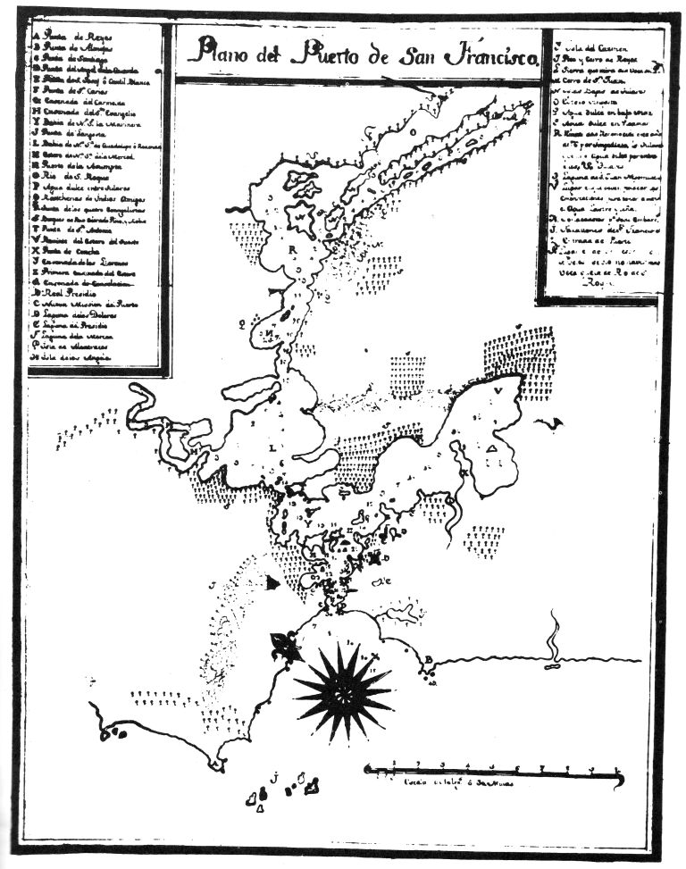
Left-Hand Box
A Punta de Reyes Point Reyes
B Punta de Almejas Clam Point
C Punta de Santiago Santiago Point
D Punta del Angel de la Guarda Point of the Guardian Angel
E Punta de S. Josef ó Cantil Blanco Point St. Joseph or White Cliff
F Punta de Sn Carlos Point St. Charles
G Ensenada del Carmelita Carmelite Cove
H Ensenada del Sto Evangelio Cove of the Holy Gospel
Y(I) Bahia de Na. Sa la Marinera Bay of Our Lady the Mariner
J Punta de Langosta Grasshopper Point
L Bahia de Na Sa de Guadalupe ó Redonda Bay of Our Lady of Guadalupe, or Round Bay
M Estero de Na. Sa de la Merced Cove of Our Lady of Mercy
N Puerto de la Asumpta Port of the Assumption
O Rio de San Roque St. Roch River (Sacramento River)
P Agua dulce entre tulares Fresh water in the tule swamps, San Joaquin River
Q Rancherias de Indios Amigos Villages of friendly Indians
R Punta de los Quatro Evangelistas Point of the four Evangelists
S Bosques de Palo Colorado, Pino, y roble Forests of redwood, pine, and oak
T Punta de San Antonio Point St. Anthony
V Remate del Estero del Sueste End of the southeast bay
X Punta de Concha Snail shell point
Y Ensenada de los Llorones Cove of those who weep or cove of the spurs. The former is Castilian, the latter and Americanism.
Z Primera ensenada del estero First cove of the Bay
1 Ensenada de Consolacion Consolation Cove
2 Real Presidio Royal Garrison
3 Nueva Mision del Puerto New Mission of the port, i.e., San Francisco Mission
4 Laguna de los Dolores Lake of the Sorrows
5 Laguna del Presidio Lake of the Garrison
6 Laguna de la Merced Lake of Grace
7 Isla de Alcatraces Alcatraz Island
8 Isla de los Angeles Angel Island
Right-Hand Box
1 Isla de Carmen Island of Carmen
2 Pico y Cerro de Reyes Peak and hills of the Kings [The hills of Marin Co. and Mt. Tamalpais are included.]
3 Sierra que mira a la Voca del P. Range which overlooks the mouth of the port [i.e., the East Bay hills]
4 Cerro de Sn Juan Hill of St. John [The hills of northeastern Contra Costa Co.]
5 Islas Bajas de Tulares Low islands covered with tules
6 Estero angosta Narrow bay
7 Agua dulce en baja mar Fresh water at low tide
8 Agua dulce en Pleamar Fresh water at high tide
9 Remate de lo Reconocido este año de 1776 por impedirlo los Tulares y venir el agua dulce por entre ellos. End of the reconnaissance this year, 1776, because the tule swamps stopped it and because fresh water was coming through them
10 Tulares Tule swamps
11 Laguna de Sn Juan Nepomuceno Lake of St. John of Nepomuk
12 Lugar en que deven fenecar las embarcaciones para tener a mano el agua, lastre, y leña. Place where ships should be stopped in order to secure water, ballast, and firewood
13 Fondeaderos pa toda embarcs Anchorage for all ships
14 Farallones de San Francisco The Farallon Islands
15 Entrada del Puerto Entrance to the port
16 Lugar en donde desde unos Arvoles se vio no haver mas vaca que la del Rio de Sn Roque. Place where, from some trees, it could be seen that there was no river mouth except that of the St. Roch River
Map 2. Map of the Port of San Francisco, drawn by José Cañizares, 1776. The original is in the Ministry of War, Madrid, Spain.
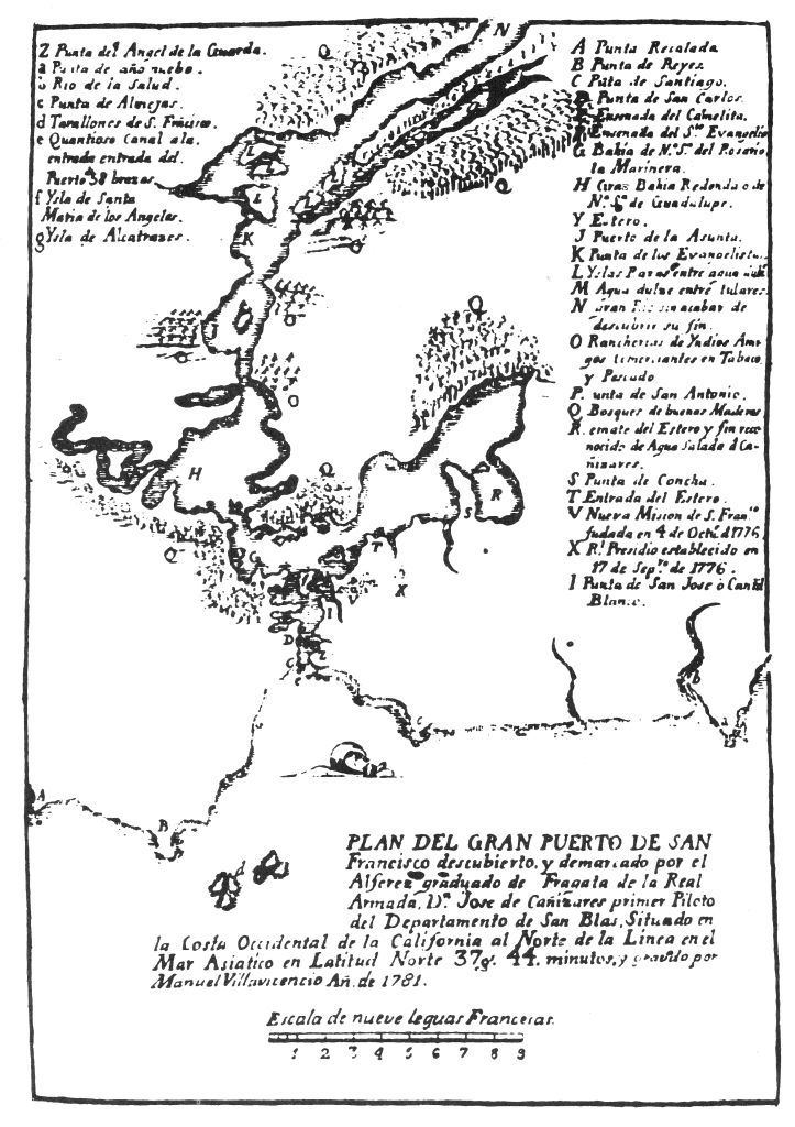
Left-Hand Box
Z Punta del Angel de la Guarda Point of the Guardian Angel
a Punta de año nuebo New Year's Point
b Rio de la Salud River of Health
c Punta de Almejas Clam Point
d Farallones de San Francisco The Farallon Islands
e Quantioso canal a la entrada del Puerto de 38 brazaz Sizable channel at the entrance of the Port 38 brazes 1 deep?
f Ysla de Santa Maria de los Angeles Angel Island
g Ysla de Alcatrazes Alcatraz Island
Right-Hand Box
A Punta Recalada Recognition Point
B Punta de Reyes Point Reyes
C Punta de Santiago Santiago Point
D Punta de San Carlos Point St. Charles
E Ensenada a del Carmelita Carmelite Cove
F Ensenada del Sto Evangelio Cove of the Holy Gospel
G Bahia de Na Sa del Rosario, la Marinera Bay of Our Lady of the Rosary, the Mariner
H Gran Bahia Redonda o de Na Sa de Guadalupe Great Round Bay or Bay of Our Lady of Guadalupe
Y Estero Cove
J Puerto de la Asumpta Port of the Assumption
K Punta de los Evangelistas Point of the Evangelists
L Yslas Razas entre agua dulce Flat islands in fresh water
M Agua dulze entre tulares Fresh water in the tule swamps
N Gran Rio sin acabar de descubrir su fin Great river the end of which was not discovered
O Rancherias de Yndios Amigos comerciantes en tabaco y Pescado. Villages of friendly Indians, traders in tobacco and fish
P Punta de San Antonio Point St. Anthony
Q Bosques de Buenas Maderas Forests of wood lumber
R Remate del Estero y fin reconocide de agua salada de Cañizares. End of the bay and end of the salt water as determined by Cañizares
S Punta de Concha Snail shell Point
T Entrada del Estero Entrance to the bay
V Nueva mision de S. Franco fudada en 4 de Octur. 1776. New Mission of San Francisco founded on 4 October 1776
X Rl Presidio establecido en 17 de Sepre de 1776. Royal Garrison established 17 September 1776
Z Punta de San José ó Cantil Blanco Point St. Joseph or White Cliff
Map 3. Revised map of Cañizares, apparently redrawn by Manuel Villavicencio in 1781, presumably under the supervision of Cañizares himself.