PART II.
Reading edition
SOUTH AMERICAN DOMINIONS.
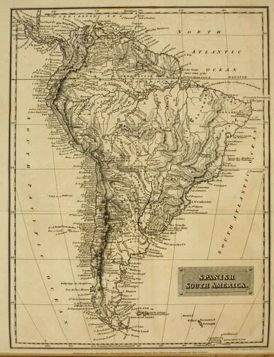
Spanish South America. Sidy Hall sculpt. 14, Dury Stt. Bloomsby Published as the Act directs. Augt. 20, 1818, by Longman, Hurst, Rees, Orme & Browne, Paternoster Row, London.
SPANISH AMERICA.
PART II
SOUTH AMERICAN DOMINIONS.
The dominions of Spain in North America having been described as fully as the nature of the work permitted, our attention is now to be turned to the acquisitions of that power in the southern division of the American continent.
The territories acquired by Spanish enterprise in South America are more extensive than those which have just been treated of; they reach from the Canataguan chain of mountains, between the provinces of Veragua and Panama, in the isthmus of Darien, to the gulf of Chonos; but Cape Vela, the extreme northern point of South America, being in a higher latitude than the Sierra de Canatagua, it is usual to reckon the total length from it. This cape is in 12° north, and the gulf of Chonos in 44° south latitude[A]: thus the Spanish colonies extend through a space equal to 3360 geographical miles, while their breadth, taken at a medium, is about 900 of the same miles. In fact, nearly the whole of that vast division of the New World, called by the general name of Southern America, is divided between two European powers, the Spaniards, and the Portuguese; the Portuguese holding the eastern, the Spaniards the northern, western and most of the southern part; the colonies of Great Britain and France being only slips of coast; and even the unconquered countries are very small, when compared with those belonging to the two powers first named.
Adding to this immense tract the kingdoms of Mexico and Guatimala, it appears that Spain possesses in the Americas an empire reaching from the 39th degree of north, to the 44th degree of south latitude; or a space included in eighty-three degrees, which is greater than the length of Africa, or more than five thousand miles.
BOUNDARIES.
The boundaries of the South American dominions are the province of Costa Rica, in the kingdom of Guatimala on the north-west; the Caribbean sea on the north; the Atlantic Ocean, British and French Guiana on the north-east; the Portuguese territories on the east; the Pacific Ocean on the west; the Atlantic and native tribes on the south-east; and the native tribes, and desert countries on the south.
POLITICAL DIVISIONS.
Spanish South America is divided into five governments; viz. the viceroyalty of New Granada; the Capitania General of Caraccas; the viceroyalty of Peru; the viceroyalty of La Plata, or Buenos Ayres; and the Capitaneria General of Chili; these are again subdivided into numerous provinces, which will be detailed in the descriptions of the different governments.
ERA OF DISCOVERY.
The discovery of the Spanish South American continent may justly take its date from the period at which Columbus landed on the coast of Paria, near the island of Trinidad, and the mouths of the Orinoco; which event took place in the month of August in the year 1498, and will be related hereafter at length. The discoveries of particular portions, the conquests and colonizations, will also be duly noticed in treating of the different governments; commencing with the most northern, and proceeding gradually, to those which occupy the southern portion of this great continent; concluding the whole with a description of the islands of most note on the coasts.
The viceroyalty of New Granada will therefore first engage our attention.
VICEROYALTY OF NEW GRANADA.
BOUNDARIES AND EXTENT.
New Granada is bounded on the north by the Caribbean Sea, and the province of Costa Rica in the kingdom of Guatimala; on the east by the government of Caraccas, Spanish Guiana, and Portuguese Guiana; on the west by the Pacific Ocean; and on the south by the river Maranon, and the viceroyalty of Peru: its extent from 3° 30ʹ south latitude to 12° north latitude, is about 930 geographical miles, its mean breadth being 240.
TERRITORIAL AND POLITICAL DIVISIONS.
This extensive viceroyalty is divided into numerous provinces, governed by intendants and governors under the orders of the viceroy.
These provinces are named Jaen de Bracamoros, Quixos, Maynas, Quito, Tacames, Popayan, Antioquia, Santa Fé, San Juan de los Llanos, Merida, Santa Marta, Carthagena, Choco, Darien, Panama, and Veragua; the three last of which are known by the distinctive appellation of Tierra Firme.
DISCOVERIES.
The coasts of New Granada which border on the Caribbean Sea were first visited by Columbus during his fourth voyage. Sailing from Spain to the West Indies, he arrived with his fleet at St. Domingo, in Hispaniola, where the governor Ovando, from private pique, refused him permission to enter the harbour and refit his vessels. This unforeseen occurrence obliged the admiral to stand to the west; after sailing in this direction for a few days, he discovered a little island, off the coast or cape of Honduras, where his brother landed, and traded with the natives. Prosecuting their voyage, they touched at the Cape itself, then called by Columbus Cape Casinas, and on which the admiralʼs brother landed to take formal possession for the crown of Spain: after this ceremony the fleet proceeded along the shore, and was compelled by the easterly winds to double a cape, which the pilots performing with difficulty, gave it the appellation of Gracias à Dios (thanks to God), because they could now take advantage of those winds in navigating along such unknown coasts with comparative safety.
Columbus touched at many places in this voyage, at Veragua, Nombre de Dios, Belem, Porto Bello, &c. At Veragua he sent his brother up the country to search for gold, and Don Bartolomeo returning with a considerable quantity; the admiral wished to have planted a colony, but having made several fruitless attempts, and finding that the ships were very rotten and worm-eaten, he set sail for Hispaniola to procure new vessels and supplies; in this attempt he was forced by storms to run on shore in a creek in the island of Jamaica, where he propped up the worn-out hulls with shores, building huts on the decks for the crews. Columbus remained almost a year in this condition, and from the mutinous behaviour of his men, his life was several times in danger; this, combined with the fatigue and vexation he had undergone, seriously affected his health, and at length, worn out with watching for succour, he determined as a last resource, to send over a canoe to Hispaniola, with one of his most faithful followers, and some Indians. These men after encountering great dangers, succeeded in reaching that island, and there procured a small ship, (but not without much opposition from the enemies of Columbus,) in which this great and unfortunate man returned to Spain, where he fixed his abode at Valladolid, and closed his illustrious career on the 20th of May, 1506, at the age of 64. His body was interred in the church of the Carthusians at Seville, and a handsome monument pointed out the spot where his remains were deposited; on which was engraven this inscription:—
“A Castilla y a Leon, Nuévo mundo dio Colon.”
“To Castile and Leon Columbus gave a new world.”
Ojeda, and Amerigo Vespucci, as well as many other adventurers, followed Columbus in exploring parts of the coast of New Granada, and Amerigo gave the first regular description of the people who inhabited its shores. In the year 1508, Alonzo de Ojeda and Diego Nicuessa obtained from the Spanish crown, extensive grants in the territories now known by the names of Guatimala and New Granada; Ojeda had the country from Cape de la Vela to the Gulf of Uraba, or Gulf of Darien, included in his charter, which tract was to be styled New Andalusia; and Nicuessa was appointed to govern from the Gulf of Darien to Cape Gracias à Dios; the territory included between these points, to be named Golden Castile, and they left Hispaniola in the latter end of the year 1510, to assume the functions assigned to them. Soon after the arrival of Ojeda at Carthagena, (then called Caramari by the Indians,) he imprudently attacked the natives, and after a severe action, lost the greater part of his men, but was fortunately relieved by the arrival of the fleet of Nicuessa; he then went to the gulf of Darien, and established a colony on the eastern promontory, which place was named St. Sebastian; but being soon reduced to great extremity for want of provision, Ojeda sailed for Hispaniola, having dispatched another vessel before him to procure supplies and reinforcements for his new establishment; suffering shipwreck on the voyage, and losing all his property, he died shortly after of want.
The colony being reduced to great distress, went back to Carthagena, to endeavour to fall in with the reinforcements; by great good fortune they met two vessels with their supplies, and returning to St. Sebastian, found their town destroyed by the natives; to augment their misfortunes, they run their ships ashore, but by dint of great exertion they were at last floated, when the whole colony, by the advice of Vasco Nunez de Balboa, sailed to the river of Darien, where they attacked and conquered an Indian tribe, and founded a town which was named Santa Maria el Antigua del Darien, where they received a further reinforcement by accident, in November 1510.
In the mean time, Nicuessa, who also suffered great misfortunes, had endeavoured to establish a colony at Nombre de Dios; a deputation was sent to him here, to request him to come and assume the government of Santa Maria; he accordingly departed, but on his arrival, found that great dissensions had arisen amongst the colonists, who, instead of appointing him to the government, put him into a rotten vessel, and sent him to sea, where it is conjectured, that himself and his crew perished. The province of Tierra Firme, including both the grants of Nicuessa, and Ojeda, was given by a subsequent charter, in the year 1514, to Pedro Arias de Avila, under whose government Vasco Nunez de Balboa was beheaded on account of a revolt. It was this man who, in 1513 on the 25th of September, first descried the Pacific Ocean, from the mountains of Terra Firma, and embarking on its waters in a canoe, explored part of its shores, on his return making known to the Spanish nation, the existence of another sea beyond the Atlantic. The first discoveries of Ojeda in New Granada took place in 1502; in 1503, Roderigo Bastidas of Seville visited the coast from Santa Marta to the river of Darien. Thus in these years, the whole shore from the Gulf of Venezuela to Cape Honduras, had been explored by different navigators and adventurers.
In 1504, Bastidas resumed his discoveries, and proceeded to the gulf of Darien to procure gold and slaves; he here found grains of gold in the sands, which was the first time the metal had been sent in that state to Spain.
In 1515, the western coast of Panama, Veragua, and Darien, was explored under the orders of Avila, as far north as Cape Blanco; and the town of Panama was founded; from this city issued the conquerors of Peru, Francisco Pizarro, and Diego Almagro, of whom we shall have occasion to speak at length in the description of that country; they are mentioned at present, because the discovery, the conquest, and the colonization of most of the internal provinces of New Granada was achieved under their orders, by Sebastian de Benalcazar, one of the officers of the army who accompanied Pizarro and Almagro in their expedition.
In 1536, Benalcazar attacked the southern provinces from Quito, whilst Gonzalo Ximenes de Quesada, who had been sent by Lugo, the admiral of the Canaries, over-run the northern districts from Santa Marta; they met with considerable opposition from the natives, but finally succeeded in reducing the country, and the whole was formed into a kingdom, and governed by a captain-general, in the year 1547; to check whose power, the royal audience was established, of which he was made president.
In the year 1718, a viceroy was appointed; this office was suppressed in 1724, and again finally established in 1740.
In the viceroyalty of New Granada, at present, there are two royal audiences, or supreme courts of judicature. The audience of Santa Fé has jurisdiction over Veragua, Panama, Santa Marta, Maracaybo in Venezuela; Antioquia, Choco, and the Llanos, with some others. The royal audience of Quito has all the southern provinces of New Granada under its superintendance.
The power of the viceroy is as great as that of the same officer in New Spain, but his revenue only amounts to the annual sum of 8400l. sterling. In the kingdom he governs, the population has been estimated at 1,800,000, of which there are upwards of 200,000 souls more in the audience of Santa Fé, than in the audience of Quito. The value of the gold and silver produced in the mines, annually amounts to 650,000l. sterling.
At Santa Fé de Bogota, the capital, besides the royal audience, there is a treasury, a tribunal of accounts, a royal mint, with many other judicial and state offices; the court of the royal audience is formed of five supreme judges, a fiscal, a protector of the Indians, and numerous subordinate officers. Santa Fé is also an archbishopric, founded in 1562, having Popayan and Carthagena as suffragans. This archbishopric is of great importance, the viceroyalty having been occasionally confided to its jurisdiction both in civil and religious matters. The president of the royal audience of Quito is governor of all the southern provinces, and is subordinate only to the viceroy.
Of the commerce of the viceroyalties in South America, we have very little correct information; the value of the import trade of New Granada has been stated as amounting to 1,235,000l. sterling, and its agricultural produce at 433,330l. The greatest revenue which the mother country receives during the most plentiful times, and when the mines are in the highest state of activity, amounts only to 108,330l.; but very frequently the expences of the administration render it impossible to remit even this small sum.
The gross revenue does not exceed 823,340l., as the contraband trade greatly injures the receipts of the customs in this kingdom; the vicinity of powerful neighbours who are all of great mercantile spirit, renders it utterly impossible for the agents of the government to check this traffic altogether. The Portuguese goods are poured in from their frontier by the great rivers; the British from the West India islands, and from Guiana; and thus, even before the present unhappy struggle, the existence of the viceroyalty depended entirely on the produce of the mines and of some few manufactures, with the native products which Europe could not dispense with. The manufactures are of utility only in its internal trade, and consist chiefly of carpets, cotton cloths, blankets, woollens, counterpanes, &c. The natural productions are the excellent dye-woods of the northern shore, which are reckoned even superior to those of Yucatan, timber for ship building, the mahogany of Panama, better and more beautiful than that of Guatimala or New Spain, chocolate and cacao, from the borders of the great river Magdalena, and the marshes of Guayaquil; excellent cotton, some tobacco, cochineal, coffee, and medicinal drugs, amongst which are the celebrated cinchona, or Jesuits bark, and contrayerva.
The mines of New Granada are however the objects of the greatest importance to its commerce. It may be said, that this kingdom is as rich in mineral treasures as any of the Spanish transatlantic colonies. In the provinces of Antioquia and Choco, it is alone richer in gold than any other, and the silver procured here is remarkably pure; lead and copper are also found, but little sought after; emeralds and other precious stones are sent to Europe. Platina, that valuable metal, was long thought to be peculiar to the province of Choco. Mercury, so useful in a mining country, has been lately discovered to exist in the province of Antioquia, in the valley de Santa Rosa, in the mountains of Quindiu, and near the village of Cuença, in the province of Quito. Salt is obtained in great quantity, and the kingdom produces many other valuable mineral substances.
Cassava or manioc root, and maize, form the bread of the Indians. European wheat is cultivated by the Spaniards and their descendants, and the tropical and European plants and vegetables are produced in as much abundance as they are in New Spain. The rivers and lakes are well stored with fish, and the woods and plains with game. The animals are such as are common to all South America, and will be noticed in the provincial descriptions; in this kingdom the inhabitants breed immense numbers of horses and mules, which they sell in Peru.
The native Indians are divided into numerous tribes, which inhabit the provinces, and the widespread forests and savannahs, between the Andes and the Portuguese dominions. When this country was first conquered by Benalcazar and Ximenes de Quesada, they were very numerous, and those who inhabited the ridges of the Andes were nearly as far advanced in improvement and civilization, as the Mexicans and Peruvians; from both of whom they were however totally distinct, being unknown to the former, and but recently subjugated by the latter. They defended themselves with great perseverance and resolution against the Spaniards, and it was very long before they were totally subdued.
Of all the tribes who then inhabited this country, the people of Quito and the Moscas, or Muyscas, were the most civilised and the most numerous. The traditions of the Muyscas reached to very early ages, and the most remarkable point in their history was the mysterious appearance of their great legislator Bochica, son of the Sun, who came suddenly amongst them whilst they were disputing about who should be their king. He is represented as a white man, clothed in long garments, with a venerable beard, who having patiently listened to the contending parties, advised them to choose Huncahua, which they accordingly did; and this chief subdued the country extending from the plains of San Juan, to the mountains of Opon. Bochica lived amongst them two thousand years, and then suddenly disappeared near the town called Hunca, since named by the Spaniards, Tunja. The kingdom of Huncahua was called Cundinamarca, and the ruler had the title of zaque, analogous to that of inca among the Peruvians; but the high priest who succeeded Bochica was in fact the supreme governor; and his authority has aptly been compared to that of the Tartarian Lama. The other princes, or chiefs of tributary tribes were called zippas. Bochica invented the calendar of the Muyscas, and regulated all their festival; he divided the day and night into four parts. Their week he made of three days, and the year was separated into moons; the common year consisting of twenty moons, whilst that of the priests, by which the festivals were regulated, contained thirty-seven; and twenty years formed a cycle.
The language of the Muyscas, which has been grammaticized by Bernardo de Luga, is now nearly extinct. It is called the Chibcha, and has neither the l or d; its chief characteristic being the frequent repetition of the syllables, cha, che, chu; they had words to express the ten numerals, beyond which they added the word foot, (counting by the toes in addition).
These people were sanguinary in their worship of Bochica and the gods. At the end of every fifteen years, they sacrificed a boy, who had been previously educated in the chief temple until he was fifteen. On this occasion, the priests led the victim with much ceremony to a column erected in a sacred spot, to which they bound him, and in the presence of the assembled nation, he was dispatched by the arrows of the warriors, after which, his heart was torn out, and offered on the altars of Bochica.
They appear to have known the use of a rude sort of dial, by the columns which were erected in various places, and to one of which, the boy victim was always attached; they had also attained some knowledge in sculpture, as their calendar was engraved on a stone, and other specimens of the progress they had made in this art have been occasionally found.
The ancient state of the town of Quito, and the first discoveries and settlements of the southern and eastern regions of New Granada, by Benalcazar and his followers, will be treated of under the head of the presidency of Quito.
Climate.—The climate of New Granada presents great variety; the elevated Cordillera of the Andes, and the eternal snows which cap its summits, render this country, though it lies partly under the equator, subject to all the cold of the polar regions; whilst on its low savannahs, the tropical heats are felt with all their ardour. The elevated plains between the ridges of the Andes, enjoy a temperate and unvariable climate, and it is in these delightful spots, that the European colonists have chiefly fixed their abodes.
FEATURES OF THE COUNTRY.
The great feature of the kingdom of New Granada or Santa Fé, is that amazing range of mountains denominated the Cordillera of the Andes, which crosses the country from the south to the north, and as some of the most sublime scenes in that astonishing chain exist in this viceroyalty, a general description of the whole will be given here from the latest sources of information.
The Andes run nearly parallel to the coast of the Pacific Ocean, at the general distance of about 150 miles, and may be satisfactorily traced from the river Atrato, in 8° north latitude, on the isthmus of Panama, as far south as Cape Pilares, at the western entrance of the Straits of Magellan, in 53° south latitude, being a length of 4200 miles. Their greatest altitude is conjectured to take place nearly under the equator, where the cone of Chimborazo rises to the amazing height of 7147 yards above the level of the sea, but they insensibly decrease in elevation towards the province of Darien, and in running through the isthmus of Panama are nearly lost; after passing the province of Darien, they again begin to evince their majestic forms, and dividing North from South America, enter the province of Veragua, pass to that of Costa Rica, and through the kingdom of Guatimala, where they again attain considerable elevation, and in which they are thickly set with volcanic cones.
Leaving Guatimala, the Andes ascend through the viceroyalty of New Spain, near the capital of which, their summits are scarcely inferior to Chimborazo, and continuing their immense course, they pass the confines of New Spain by the province of New Mexico; entering a wild and unfrequented country, where the elevation of their peaks is still very great; and they are supposed finally to lose themselves in the icy ocean of the Arctic regions.
That part of the Andes which crosses New Spain and Guatimala has been already described. Three secondary chains are thrown out in the known parts of South America; the first of these is in the kingdom of New Granada; the second is known by the name of the Cordillera of the cataracts of the Orinoco; and the third is the Cordillera of Chiquitos, which province it traverses.
The first branch, or Cordillera of New Granada and Caraccas, bends eastward from the river Atrato, forming the Sierra of Abibé, and of Cauca, and the high plains of Tolu, and crosses the river Magdalena. It then forms a narrow chain along the coast to Cape Vela, where it separates into two parallel ridges; but joining again, and forming lofty summits, it stretches along the whole government of the Caraccas, and loses itself in the Atlantic ocean, at the cape of Paria. Its highest points are in the provinces of Santa Marta and Merida. The Nevada of the former is 16,000 feet, and that of the latter 15,000 in altitude, and their heads constantly enveloped in snow. These parallel ridges form vast plains between their summits, elevated to great heights above the sea; the plain of the Caraccas being 2660 feet in height. The greatest elevation of the chain after it crosses the boundary between New Granada and the Caraccas is near the metropolis of the latter government, where the Silla de Caraccas raises itself to the height of 8420 feet, and forms an enormous and frightful precipice fronting the Caribbean sea.
In New Granada, the main chain also separates itself into parallel ridges, three of which exist between 2° 30ʹ and 5° 15ʹ of north latitude. The eastern ridge divides the great river Magdalena from the plains of the Meta; none of its summits are covered with snow. The central ridge separates the Magdalena from the Rio Cauca; this is the most lofty of the three, and its most elevated peaks enter the region of eternal frost; the three highest are named Quindiu, Baragan, and Guanacas.
The western ridge separates the Rio Cauca from the province of Choco; it attains scarcely 4500 feet in altitude, and nearly loses itself in the province of Darien. These three ridges unite in the district of Pastos in Popayan, and continue single till they have far past the equator; when they again separate themselves into two parallel chains, in the province of Quito, by a valley near their summits. It is here that they are seen in their most sublime forms, Chimborazo, Pichincha, Illinissa, Antisana, and Cotopaxi ascending to the very skies, their white cones being beautifully contrasted with the dark blue of the surrounding firmament.
The second branch of the Andes, called the Cordillera of the Cataracts of the Orinoco extends itself from the great chain eastward between the 3d and 6th degrees of north latitude, where the high plains of Tuquillo and St. Martin, with the peaks of Canavami and Umama are formed; it contains the sources of the Guaviari, the Meta, Zama, and Ymerida rivers, and forms the tremendous cataracts of Maypuré and Aturé; beyond these it acquires still greater elevation, and occupies an immense space, stretching southward to the boundaries of the Portuguese dominions, where it is lost in vast and nearly impenetrable tracts of woody country, over which no European ever trod, as the tribes who inhabit the region are of a ferocious and sanguinary disposition. In this gloomy country exist the sources of the magnificent Orinoco, which have never been seen, either by the civilised Indians, or the Spaniards. The chain has again been observed issuing from forests farther to the eastward; it is, however, neither so elevated nor so broad, and is called Sierra de Quineropaca and Pacaraimo, near the lake of Parimé and the Amazons. It again extends its breadth a few degrees further east, and bends southwards along the Mao, where the hill of Ucucuamo, which being formed of shining yellow mica, deceived the venturous travellers, who fancied they at last found a mountain of gold. From this hill, called El Dorado, or the Golden Mountain, the branch stretches eastwards towards the mountains of French Guiana, where its form is little known, as the interior of that country is inhabited by Caribs and negroes, who keep the settlers at bay. The rivers of Berbice, Surinam, Marony, and Essequibo rise in this part of the chain.
The mountain of Duida is the highest point which has yet been seen of the Cordillera of the Cataracts; this volcano has not hitherto been explored, but its height has been found to be 8465 feet above the sea.
The Cordillera of the Cataracts is remarkable for the abrupt descent of its southern face.
It is said to exhibit no rock of secondary formation, or to contain any petrifactions or organic remains, consisting only of granite, gneiss, mica, slate, and hornblende; this however applies only to the part visited by M. de Humboldt, from the Rio Negro to the frontier of the Grand Para, a distance of 600 miles.
The third great branch from the main body of the Andes, is that of Chiquitos, between the 15th and 20th degree of south latitude, which, sweeping from the main chain in a semicircular shape, traverses the province of the same name, connecting the heights of Paraguay and La Plata with those of Chili and Peru. The great rivers which fall into, and form parts of the La Plata and the Maranon, rise in this branch, but as no satisfactory accounts of it have been published, it is impracticable to give any general description of its particular properties and forms.
These branches form three immense plains between their bases, open to the southern Atlantic Ocean on the east, and shut out from the Pacific by the great trunk of the Andes on the west; the most northerly is the Savannah, or Plain of the Orinoco, noted for its luxuriant herbage, and possessing only a few scattered trees. The plain of the Amazons, or Maranon, succeeds to that of the Orinoco on the opposite side of the central branch. On this widely extended tract, forests, coeval with the soil they are nourished by, extend their gloomy and nearly impenetrable fastnesses, inhabited only by tribes of savage and wandering Indians, whose ferocity allies them to the beasts of prey which roam in every part of the savannahs of the Maranon.
The third great plain is that distinguished by the appellation of the Pampas, or the Plains of the La Plata, resembling in some measure the valley of the Orinoco, being covered with a strong and luxuriant growth of herbage, and occupied by countless herds of wild cattle, which are hunted solely for the sake of their hides, these forming one of the chief articles of the export trade of the viceroyalty of Buenos Ayres.
The mother chain of the Andes is rich beyond description in metallic productions, and furnishes several sorts of the precious stones; but with all this profusion of treasure, it contains within its bosom the materials of destruction; earthquakes of the most tremendous nature swallow whole cities, the activity of the internal fires frequently destroys entire mountains, and leaves sheets of water in their place, by which provinces are devastated, and thousands of the animal creation destroyed. Forty volcanoes have been counted from Cotopaxi to the shores of the Straits of Magellan, that discharge lava, enormous rocks, showers of ashes, great quantities of water, liquid mud, sulphur, or devastating blasts of heated air from their craters.
The most striking features of the southern Andes are these volcanic cones, whose flanks, beset with frightful crevices of immeasurable depth, are crossed by the fearless natives, by means of pendulous bridges, formed of the fibres of equinoctial plants. Over these frail and tremulous passages, the natives carry the traveller in a chair attached to their backs, and bending forward the body, they move with a swift and equal step; but when they reach the centre, the oscillation of the bridge is so great, that were they to stop, inevitable destruction must ensue; the native and his burden would be dashed to the bottom of a precipice to whose profound depth the eye can hardly reach.
These bridges are, from the nature of their materials, frequently out of repair, presenting to the shuddering European, who visits these countries, frightful chasms, over which the Indians step with undaunted confidence. Volcanoes and crevices are not the only surprising circumstances which attract the notice of the adventurous traveller; cataracts of magnificent forms are every where observed, that of Tequendama, near the city of Santa Fé, dashing a volume of water from the plains of Bogota, through an opening in the Cordillera, to the depth of six hundred feet, into a dark and unfathomable gulf. In these mountains, the largest rivers in the world derive their sources; the La Plata, the Maranon, and the Orinoco; of which, as well as of some of the peculiar scenery of the Andes, we shall treat more at large in the local descriptions of the governments and provinces of South America, resuming the subject of the present section, we shall describe the capital of the kingdom of New Granada.
Capital.—The metropolis of the viceroyalty of Santa Fé, or New Granada, is the city of Santa Fé de Bogota, in north latitude 4° 6ʹ, and west longitude 78° 30ʹ, near the river Funza, or Pati. It was founded in 1538 by Ximenes de Quesada when he conquered the tribes who then inhabited this country.
Santa Fé is situated in a spacious and luxuriant plain to the east of the great chain of the Andes, and between it and its first parallel branch; though only four degrees from the equator, the elevation of 8694 feet above the level of the sea renders its climate rather cold. The city is large, and handsomely built, containing four great squares, with wide, regular and well laid out streets. Two small rivers, the San Francisco, and San Augustin, run through the town, and join the main stream of the Funza at a short distance; over these rivulets, five handsome bridges are erected. The cathedral is a magnificent structure, and forms the chief ornament of the place, which also contains three other churches, eight convents, four nunneries, and an hospital; the university was founded in the year 1610, since which time two colleges have been endowed for public education; and a library was established in 1772. Besides the above mentioned churches, there are several others, as well as numerous chapels, all of which are tolerably well built. There is also a royal mint, several courts of justice, and state offices, necessary for the government of the viceroyalty.
The city is governed by six regidores and two alcaldes, with some subordinate officers; their jurisdiction extending over fifty-two villages in the neighbourhood, which are divided into seven districts. The inhabitants, amounting to 30,000, are in general not very wealthy, and most of them are occupied in the internal trade of the country. They are represented as possessing agreeable manners, and much good sense, combined with a considerable degree of industry; the latter quality is manifested by the appearance of the plain surrounding the city, which they take so much pains with, as to cause it to produce two harvests in the year. The elevation of this plain renders the temperature of the air so equable, that the Bogotians enjoy a perpetual spring.
The viceroy of New Grenada has a palace in Bogota, which is also the seat of the archbishopric, founded by Pope Julius III. in 1554, and the court of the royal audience of Santa Fé. In the environs are some mines of gold, as well as of Peruvian emeralds; salt and coal are found also in considerable quantities, but the difficulty of carriage renders the latter very expensive.
The cataract of the Tequendama, by which the river Funza joins the Great Magdalena, is the most noted object in the surrounding country. The Funza or Bogota, after receiving the waters of the numerous small rivers which flow through the great plain, is about 140 feet in breadth, a short distance above the fall; approaching the crevice through which it dashes, its breadth is diminished to thirty-five, when, with accumulated force, it rushes down a perpendicular rock at two bounds, to the astonishing depth of 600 feet, into a dark, unfathomable gulf, out of which the river again issues under the name of Rio Meta, and continues its course, by an immense descent, till it joins the great river Magdalena.
In the fall of this river may be observed a strange variety of climate. The plain of Bogota is covered with crops of wheat, with oaks, elms, and other productions of a temperate region. At the foot of the fall are seen the palms of the equinoctial low-lands. The face of the rock, which finishes and borders the vast plain of Bogota, near the cataract, is so steep, that it takes three hours to descend from the river Funza to the Rio Meta; and the basin or gulf cannot be approached very close, as the rapidity of the water, the deafening noise of the fall, and dense mass of vapour, render it impossible to get nearer the edges of the abyss than four or five hundred feet. The loneliness of the spot, the dreadful noise, and the beauty of the vegetation, render this situation one of the wildest and most picturesque scenes that are to be observed in the Andes.
When Quesada first arrived at Bogota, he discovered that the inhabitants, whom we have spoken of under the name of Muyscas, were rapidly approaching to civilization. The xaque or prince was absolute; his people carried him about in a sort of palanquin, attended by his guards and courtiers; whilst flowers were strewn along the ground over which he was to pass. They never approached him but with an averted countenance, as if they imagined that he was a divinity, in whose face they dared not look.
These people subsisted chiefly by agriculture, were clothed in cotton garments, and lived in regular society. Crimes were punished by judges appointed to watch over them, and they possessed, property independent of each other, on which taxes were levied for the support of the government. They had temples, altars, priests and sacrifices, but their religion, which consisted in the adoration of the sun, moon, Bochica, his descendants, and the evil deities, was intermixed with barbarous and bloody ceremonies; they resembled the Mexicans, with whom they had no connection, in a particular point of these immolations; the heart of the living victim was torn out, and supposed to be the most grateful offering to their gods.
One of their notions of the power of Bochica, and of the formation of the moon, is singular; and as it relates to the cataract of the Tequendama, we shall give it at length.
In remote times, when the sun alone gave the earth light, and the people of the plain of Bogota were savage barbarians, an old man, totally unlike the natives, suddenly appeared amongst them from the east, with a white beard and flowing garments.
This was Bochica. He instructed them in agriculture, &c., and with him came a woman, who, as well as himself, had three names, one of which was Chia; she was very beautiful, very malevolent, and overturned every thing Bochica attempted; by her magic she swelled the rivers and overflowed the plain, so that the people, with the exception of a few, who escaped to the mountains, perished in the waters. Bochica, exasperated at her conduct, drove Chia from the earth, and she became the moon. He then, by the mighty force of his arm, broke a passage through the rocks, and constituted the fall of the Tequendama, by which means the lake formed by Chia was drained; and the plain of Bogota rendered more fertile and beautiful than it had been before.
The appearance of the plain of Bogota at this moment justifies the tradition of its having been formerly a lake; low summits appear here and there like islets; and the whole plain is rendered marshy by the numerous streams which cross it in every direction.
In the kingdom of New Granada there are two mints, one in Popayan and the other in Santa Fé. The coinage of the capital is greater than that of Popayan; the total coined produce of the gold mines in 1801, was 455,000l.; whilst wrought gold and ingots were exported to the amount of 52,000l.; making the value of the gold found during that year 507,000l. This gold is not found by digging, although many mines with auriferous veins exist, but by washing the alluvious grounds, and is chiefly collected by negroes.
The provinces governed by the viceroy of New Granada have been already enumerated. The most northerly of these are the three which are distinguished by the name of Tierra Firme, or Terra Firma, we shall therefore commence the provincial descriptions with them.
TIERRA FIRME.
PROVINCE OF VERAGUA.
The northernmost of the provinces, which are governed by intendants, nominated by the viceroy of New Granada, under the general designation of Tierra Firme, is the province of Veragua, situated to the south of the kingdom of Guatimala, in North America. This, from its geographical situation, has been already described in the first part; it will therefore be unnecessary to repeat any observations on its history or statistics; our attention must consequently be turned to the province of Panama, on the south, or rather east of the Canatagua mountains.
PROVINCE OF PANAMA.
Panama constitutes the second province of Tierra Firme, and is sometimes called Tierra Firme Proper. The most plausible conjecture which can be formed, as to the reason of its having received this name, is, that the original explorers, having an idea that a strait existed in this part of the world, by which a communication might be had from the Atlantic to the South Sea, were, after much research, disappointed in their expectations and gave the country the name of Tierra Firme (analogous to continent.)
The province of Panama is bounded on the north by the Caribbean Sea, or Spanish Main; on the west, by the province of Veragua; east, by Darien; and on the south, by the Pacific Ocean.
Of the discoveries of this country, we have already spoken. Tello de Guzman, in 1513, is said to have given the country the name of Panama, from having observed the natives engaged in fishing; the word denoting a place abounding in fish.
Climate, &c.—The climate of Panama is hot, as may be well supposed, from its situation, the greatest heat being felt in the months of August, September, and October, when it is almost insupportable; the brisas, or trade winds, and the continual rains, ameliorate the excessive heats during the other months; but at the same time render the climate very unpleasant.
The soil of Panama is prolific, abundantly producing the tropical fruits and plants.
Great part of the country is still covered with thick forests, and the land between the two seas consists generally of abrupt and broken chains of mountains, one of which chains, the Sierra de Canatagua, on the borders of Panamo and Veragua, divides North from South America. On the tops of these craggy mountains, the land is sterile and uninhabited; the cities, settlements, plantations, and Indian villages, being mostly along the shores of the two oceans.
The trade of Panama consists in its relations with Veragua, and the ports of Peru and New Granada. From these it is supplied with cattle, maize, wheat and poultry; its exports are of no great importance or value. From Carthagena European goods are received, for which mahogany, cedar and other woods, with gums and balsams, are exchanged. The pearl fishery here is at present of little importance; it was anciently carried on amongst the small islands in the bay of Panama, and was very lucrative; an endeavour has lately been made to re-establish it, but hitherto without any beneficial results.
Part of the European trade of the western shore of South America is carried on by way of Panama and Porto Bello; but since the galleons were disallowed, the trade of these two cities has been comparatively trifling.
The mines of Panama produce so little gold or silver, that they are supposed not to answer the expence of working.
The river Chagre is the principal stream in this province, and may be called the high road of Panama, being used as the means of communication between the eastern shore and the capital. It takes its rise in the mountains near Cruces, which place is about five leagues from Panama; the Chagre has a considerable descent, but is nevertheless navigable for boats up to Cruces; its velocity is about three miles an hour; therefore the ascent from the coast is rather fatiguing.
The breadth of this river is about a quarter of a mile at the mouth, and 150 feet at Cruces; it requires four or five days to ascend it when the waters are not very high. The distance from the estuary to Cruces, the last navigable point in a straight line, is not above 36 miles; but the river winding frequently increases this length. If the water passage is counted, the sinuosities make it 43 miles, reckoning from Fort St. Lorenzo, which defends the entrance. It is by means of this river that a communication between the two oceans has been argued to be possible; the ascent from Cruces where the river is first navigable, towards the summit of the mountains is rapid for a short space, after which there is a gentle descent the whole way to the South Sea.
In the river Chagre are seen numberless caymans or aligators; they are observed either in the water or on the banks, but on account of the thorny shrubs and thick underwood, cannot be pursued on shore. On the borders of this stream, the luxuriancy of the soil is such, that the trees stand so thick, as to render it very difficult to penetrate the forests. The barks which navigate the stream are formed of those trees which grow nearest the water; some of which are so large, as to measure twelve feet in breadth. These forests are plentifully stocked with all sorts of wild animals peculiar to the torrid regions, among which, are innumerable tribes of monkeys. Many of these creatures are caught for food by the negroes and natives. To prepare this dish, the body is scalded in order to remove the hair; and after this operation has been performed, it has the exact appearance of a young dead child, and is so disgusting, that no one, excepting those pressed by hunger, could partake of the repast. It is not at all improbable, that many savage nations who have been accused of cannibalism, have been very unjustly charged with it; for according to Ulloa, the appearance of the monkey of Panama, when ready to be cooked, is precisely that of a human body.
The peacock, the turtle-dove, the heron, and various other sorts of beautiful birds, frequent the forests of the Chagre and of Panama, and the country is dreadfully infested with reptiles, insects, &c.
The province of Panama contains three cities, twelve villages, and numerous settlements of converted Indians. The capital is Panama, a city and sea-port, built near the bottom of a large bay of the Pacific which bears the same name. From this city, the isthmus of Darien has frequently taken its appellation; but at present is indifferently styled the isthmus of Panama, or of Darien. It stands in 9° 0ʹ 30ʺ north latitude, and 79° 19ʹ west longitude. Tello de Gusman gave the country its name from this spot. In 1518, Pedro Arias de Avila, governor of Tierra Firme, settled a colony here, and in 1521, it was constituted a city by the Emperor Charles the Fifth. In 1670, it was sacked and burnt by Morgan, an English adventurer, who had already reduced Porto Bello and Maracaybo; he debarked at the mouth of the Chagre, reducing the fort there after an obstinate defence, and ascending the river, landed again at Cruces and marched to Panama, where after several skirmishes, he entered the city; the inhabitants flying to the woods. Soon after he left the place it was burnt down, but whether by accident or design is not known. The inhabitants resolved to rebuild the town at about a league and a half distance from where it first stood, and in a more convenient situation. It was then enclosed with a regular stone rampart; the houses were chiefly of wood with tiled roofs, having but one story, but of a very handsome appearance; and outside of the walls was a large suburb. In 1737, a fire commenced in a house where tar, naptha, and brandy, were stored; the devouring element was so rapid in its progress, that the city of Panama was entirely consumed in a very short time, with the exception of the suburb, which was saved, it being totally detached from the town. Panama was rebuilt shortly afterwards a second time, and the inhabitants having excellent quarries in the vicinity, erected their houses chiefly of stone; but it suffered again from fire in 1756, and in 1784 it was nearly destroyed by another dreadful conflagration.
The governor of Panama was formerly captain-general of Tierra Firme, and president of a court of royal audience, which has lately been removed to Santa Fé de Bogota. The city of Panama is the see of a bishop, who is subject to the control of the archbishop of Lima; but as he receives no tithes, is paid out of the royal coffers. A municipal council governs the district of the city; a treasury, custom-house, &c. are established there, and when the galleons came from Lima, Panama, and Porto Bello, might be said to have been the Acapulco and Vera Cruz of South America.
The cathedral is a handsome edifice of stone, as are the churches, convents, monasteries, and an excellent hospital.
The streets are broad and paved, both in the city and its suburbs, but the houses of the suburbs are mostly of wood, intermixed with thatched huts. Such is the spirit of trade of this place, that every person is engaged in bartering. The people of Panama, have a disagreeable drawling method of speaking, and appear as if they were overcome by the great heat of the climate; they nevertheless are really healthy, and live in general to a good age.
One of the favourite articles of food among the lower classes, and much used with the higher, is an amphibious animal of the lizard tribe, called the guana, about three feet long, of a yellowish green colour, having a bright yellow belly, with strong claws on its toes, its back covered with thin scales, and a serrated ridge running along the superior surface of the body and tail. It lays from fifty to sixty eggs, as large as those of a pigeon, which are esteemed great delicacies; these eggs are attached to each other by a fine membrane, and form a string or chaplet. The flesh, when dressed, is as white as that of a chicken, and greatly resembles it in taste; it is served with lime-juice, cayenne-pepper, or other high sauces.
Panama is now only remarkable for its fine bay, which is studded with islands; and amongst these is formed the road where the ships from the southern ports anchor in safety, particularly before the islands of Perico, Naos, and Flamingos; the distance of this road is two and a-half, or three leagues from the town.
The tide rises and falls from thirteen to sixteen feet at Panama, whilst at Porto Bello, the flux and reflux amounts to only as many inches. The Bay of Panama is famous for the pearl oyster, and the shoals near the islands del Rey, Tabago, and about forty others which form a small archipelago, formerly produced pearls as fine as could be procured in any part of the world. On these islands, huts were built for the divers, who were mostly negroes, and boats holding from eight to ten people, went out to the banks, which were not more than fifteen fathoms under water. The divers, provided with a rope tied to their bodies, and a small weight attached, plunged into the ocean; on arriving at the bottom, they seized a shell in the left hand, which they put under the arm, a second in the same hand, a third in the right, and sometimes one in the mouth; they then re-ascended to breathe and to put the fish in a bag.
In this practice, the unfortunate slaves were frequently destroyed by the sharks, mantas, &c. The manta is a large, flat fish of great size, which wraps its fins round the object it seizes, and presses it to death. The negroes usually carry a knife to defend themselves, but notwithstanding this protection, as well as that of their comrades in the boats, numbers were annually devoured by these horrid fish.
The Isla del Rey, was first discovered by Pizarro; it was for a long time inhabited during the fishery, but whether it is or not at present, is not known.
The next city of importance in this province is Porto Bello, or Puerto Bello, on the shores of the Caribbean sea, or Spanish main, in north latitude 10° 27ʹ, and west longitude 79° 26ʹ. The harbour of Porto Bello, as its name, (Fine Port,) indicates, is an excellent one, and was first discovered by Columbus, on the 2d of November 1502, who was so charmed with it, that he gave it the name it now bears.
The town of Porto Bello was founded by order of Philip II., who directed the settlers at Nombre de Dios, or Bastimentos, to remove to this spot in 1584, on account of its admirable situation for the commerce of the country; it stands near the sea, on the side of a mountain which embraces the harbour.
The entrance of the harbour is defended by a castle, called Todo Hierro, or all Iron, on the north point, where the channel is about three-quarters of a mile broad. The south side is covered with dangerous shoals, so that vessels are obliged to keep near the castle; and opposite to the anchoring ground on the south side, is another fort, called Castillo de la Gloria, between which and the town, a point of land projects into the basin, on which formerly stood Fort St. Jerome. Opposite to the town on the north-west, is another small and perfectly secure bay, where vessels are careened.
The whole town and harbour being surrounded with high land, renders it a very safe place for shipping, particularly as this part of the Spanish main is subject to terrible storms. The mountains in the neighbourhood are of such an elevation, that one of them, called Monte Capiro, is constantly covered with thick dark clouds on its summit.
A small river which discharges itself into the harbour near the town, is salt to the distance of a quarter of a league from its estuary; this river is called the Cascajal.
The country in the neighbourhood of Porto Bello is very thinly inhabited; a few farms are found in the valleys, but the mountains are covered with thick and impenetrable forests, tenanted solely by wild animals.
The climate of this city is very unhealthy, as the heat is excessive, owing to the stagnation of the air by the wall of mountains enveloping the harbour. The humid exhalations from the forests cause frequent rains, which, though of short duration, pour down with astonishing violence. The nights are as suffocating as the days, accompanied with torrents of rain, bursts of thunder, and flashes of lightning, which fill the mind of an European on his first arrival with dread and horror. The caverns in the adjacent rocks re-echo the percussions of the thunders, and add to the dreadful noise, which is accompanied by the howlings of animals, particularly the monkeys.
The natives, as well as the Europeans, are carried off in great numbers by the fevers generated by the unhealthiness of the air, and it is this which will ever prevent Porto Bello from becoming a large city; no one living here, but those engaged in government offices, or in trade.
It is supplied with provisions from Carthagena, and fish of every quality are caught in the bay. Its manufactures are unimportant; but there are some sugar-houses in the town, where an inconsiderable quantity of that article is made. The great luxury at Porto Bello consists in the numerous streams of fresh water which pour down from the hills into the town; they are said however to be unwholesome, and to produce dysentery, if too freely used. Little reservoirs are formed here and there, shaded by trees, and in these the inhabitants bathe themselves every day.
Jaguars, and other animals, are said to enter Porto Bello during the night, and to carry off any domestic animals they meet with. They are slain in the woods by the negroes and Indians, who hunt them for the sake of a trifling reward, which is paid on their destruction.
The sloth is an animal very common in the vicinity of this city. Its habits are well known. Serpents of every deadly nature are extremely numerous. Frogs and toads are seen in such numbers after the showers, that the natives say every drop of water is changed into one of those nauseous animals. The country about Porto Bello, resembles in this instance the British settlements in some parts of North America, where toads and frogs cover the land after any humidity.
The city of Porto Bello is also called San Felipe de Puerto Bello; it consists of one principal street, extending along the shore, and crossed by several others up the side of the mountain. In it are two squares, two churches, two convents, a custom-house, and some other public buildings; at the east end of the town, in the quarter called Guinea, are the habitations of the free and enslaved negroes.
Formerly, when the galleons were permitted, this place had an annual fair, and was then excessively crowded with people. The houses at present are chiefly of wood with a few of stone, and the better sort do not amount to 150. This city is sixty miles north of Panama, and its climate is said to have been wonderfully improved by a cut which has been lately made through a neighbouring hill to admit a current of air. The governor, Don Vincente Emparan, has also levelled great part of the forests which formerly reached to the very gates of the town.
Sir Francis Drake took this place in 1596, and died in a subsequent voyage in its harbour.
When Porto Bello was taken and plundered by John Morgan, the town was ransomed for a large sum, which prevented his burning it.
In 1739, Admiral Vernon with six ships entered the harbour and made himself master of the place, after demolishing the forts. He afterwards bombarded Carthagena, and took Fort Chagre, near the mouth of the river of that name.
The population of Porto Bello is inconsiderable, being chiefly negroes and mulattoes, with about thirty white families, and the garrisons of the forts.
The third city of Panama is St. Jago de Nata de los Cavalleros, or Nata, so named from the Prince, or cacique, who reigned over this part of the province when it was explored in 1515 by Alonzo Perez de la Rua.
It is situated near the extremity of the Canataguan chain, fifty miles south-west of Panama, in north latitude 8° 35ʹ, and west longitude 81° 6ʹ, in a bay on the borders of the Pacific, which extends to the island Iguenas; it was founded by Gaspar de Espinosa, but the Indians burnt and plundered it shortly after its first erection; he again rebuilt it with the title of city.
At present it is a large place, the houses of which are built of unburnt bricks and mud. The inhabitants are a mixture of Spaniards and Indians; near it is a town called Los Santos, which has been built by people from Nata, for the sake of the excellent soil in its vicinity, on which they have formed extensive plantations.
The population of this town is greater than that of the city of Nata, and also consist of Spaniards and Indians.
In the province of Panama, there are many villages, and farms, some of which are inhabited by the Europeans and their descendants, and others by the Indians who have been converted.
PROVINCE OF DARIEN.
The third and last province of Tierra Firme is that of Darien, bounded on the north by the Spanish Main, or Caribbean Sea, on the east by Carthagena, west by Panama, and south by the Pacific Ocean, and the province of Choco.
Darien is one of the largest provinces of Terra Firma; it is about 200 miles long and 80 broad, but is very thinly inhabited, and that almost wholly by the native tribes. The unhealthiness of the climate and the impenetrable forests preventing the formation of European settlements.
The valleys in Darien are so marshy, from the overflowing of the numerous rivers that the savages build their habitations in the branches of high trees. These rivers are in many parts very large, but most of them are not navigable, owing to the shoals, bars, and rapids in which they abound; most of them, however, roll down grains of gold.
A small fort which protects the gold mines of Cana is the principal station of the Spaniards on the frontiers of Choco; its garrison is sent from Panama every month. Santa Maria el Antigua del Darien was the first settlement of the Spaniards on the Atlantic coast, but as it did not flourish, it was soon abandoned.
The chief products of this province are cotton and tobacco; it may, however, be said to be now wholly in the power of the natives, who are scattered over the whole country, and amount to about 30,000 souls, with whom the Spaniards have been frequently at war, but have as yet gained no sensible advantages. In 1786, the viceroy of New Granada sent a formidable expedition against them, but the troops being unable to bear the inclemency of the climate, the army returned to Bogota without effecting any thing.
The gulf of Darien which is the mouth of the Rio Atrato, or rather a large arm of the sea, is the most important part of the northern coast, and contains several islands of considerable size. The river Atrato though very wide, has many shoals at its mouth, yet serves to export much of the internal produce of some of the settlements in the neighbouring provinces; its mouth is a noted smuggling station, where European goods are exchanged for the gold of Choco.
The capital is Santa Cruz de Cana, which we have mentioned; it was formerly a very considerable place, and there were nine other towns or missions, with several farms and hamlets, but most of these have been abandoned, owing to the ferocity of the Indians, and other causes. The Scotch once endeavoured to form a permanent settlement in this country; a company was chartered at Edinburgh, called the Scots Darien Company in 1695. In 1698 they fitted out a small armament, in the vessels of which were embarked a numerous body of colonists, with a governor, &c. and arriving on the Isthmus, they formed a settlement in a fine port on the north-west shore, in north latitude 9° 30ʹ, west longitude 77° 36ʹ, to which they gave the name of New Caledonia. Here several families were settled, but the Spanish government being alarmed, the British court refusing to acknowledge this act, and the success of the adventurers becoming daily greater, a force was sent against them, by which means they were ejected from the country in the latter end of the year 1699, or beginning of 1700.
PROVINCE OF CARTHAGENA.
The next province of New Granada, in passing eastward from Tierra Firme, is Carthagena, so named from its capital: it is bounded on the north by the Spanish main, east by the great river Magdalena, south by the province of Antioquia, and west by the river and province of Darien. Its extent from east to west may be computed at fifty-three leagues, and from north to south at eighty-five.
This space is covered with mountains, savannahs and forests. The great plains or savannahs are those named Zinu, Zamba, Tolu, Mompox, Barancas, &c., all of which are highly fruitful valleys between the ridges of the hills. The settlements of the Europeans and natives are chiefly on the coast, or in these valleys; the hills and rivers are supposed to have formerly furnished much gold, with which a trade was carried on with the neighboring countries; and gold is said to have been so plentiful, that the natives were always ornamented with trinkets composed of that metal.
The soil of this province is very luxuriant, especially near the capital where it produces every thing in the greatest plenty. The trees attain an immense bulk, and form by their shades, pleasing retreats from the scorching rays of the sun. The mahogany or acajou, of which the canoes of the natives are formed, the white and red cedar, the maria, the balsam tree which yields an oil, the celebrated balsam of Tolu (so called from a town where it is gathered), the tamarind, the medlar, the sapote, papayo or papaw, guayubo, cassia, palm, and mançanillo, are a few of the species whose wood, fruit or sap, are so precious. The mançanillo derives its name from the Spanish word mançan, an apple, the fruit resembling the European apple in shape, colour and taste, but is of a poisonous nature; the juice of this tree is so acrid, that it blisters the skin of those employed in felling it, and it is reckoned dangerous to remain under its shade after a shower, as the droppings of its leaves have the same caustic quality.
The palms are of many different species, and form, by their broad and spreading leaves, elevated on lofty trunks, the great beauty of the scenery; of these, the produce is chiefly cocoa-nuts, dates and palm wine. The sensitive plant grows to the height of a foot and a half in the woods of Carthagena.
In its vast forests numerous tribes of wild animals are found; of these the jaguar or tiger, and the American leopard are very destructive to the cattle and domestic animals; the former grows to an amazing size, and is extremely ferocious; wild boars, foxes, armadilloes, squirrels, deer, rabbits and monkeys are produced in great plenty, most of which are eaten by the Indians and negroes whenever they catch them. The cattle and swine of this province are very numerous; their flesh, when salted, forms the principal article of commerce and of food.
Wild geese are caught in the lakes by means of an entertaining stratagem; in the places they frequent, the Indians put calabashes or gourds, which constantly floating on the surface of the water, cause no alarm to the geese, and when they are sufficiently accustomed to see them, the Indian gets into the water at a distance from the flock with a gourd over his head; he then advances amongst them, and draws them by the legs under the surface, until he has procured as many as he wants.
The birds of this province are both numerous and beautiful; amongst them the toucan with its large bill, the gallinazo vulture, which clears the country of all carcases or offensive matter, and the guacamayo or macaw, with its beautiful plumage and disagreeable voice, are the most singular.
Bats are so numerous in the city that they cover the streets in an evening in clouds, and there is not a house in which these nocturnal birds are not found. Of these the most formidable is the vampyre, which, according to the authority of Ulloa and other travellers, has been known to suck the blood of a sleeping person, at the same time fanning its victim with its broad wings.
The insects and reptiles peculiar to the climate are as numerous as the birds and beasts. Of these the centipede, the scorpion, the spider; and amongst the serpents, the rattle snake, the dart, and the dreadful corales, or coral snakes, are the most venomous, the bite of the latter being rarely cured. Whilst the feet of the pedestrian are insecure from the attacks of these dreadful creatures, his face is exposed to the venom of the mosquitoes, which attain a great size, and are exceeding troublesome.
The beds of the inhabitants of Carthagena are surrounded with gauze curtains to protect the sleeper from these insects, but this is unavailing; for another and almost imperceptible enemy creeps in through the threads, and annoys any part of the body which may be exposed; these are called manta blancas, or white cloaks (by their forming a cloud in the air of that colour); they cause no other pain than an intolerable itching.
The pique is also another disagreeable insect of this country, which penetrates the skin of the feet or hands, and causes intolerable pain; this animal it well known in the West Indies under the name of jigger, or chigoe.
Goods which belong to the merchants of Carthagena are frequently destroyed in a short time by a sort of moth, which perforates, in a single night, through and through the finest bales of cloth, linen, silks or laces; the only way they have of preventing this is to place them on benches away from the walls, and to smear the feet or supports with naptha.
The country produces neither wheat nor barley, but maize and rice in great plenty. Of the maize they form a kind of bread called bollo, which is used by the natives and Europeans; the negroes make greater use of the cassava bread, made from roots; in fact it is their chief food; whilst the opulent families use the flour of European wheat, imported from Spain. Sugar-cane plantations are very common, and rum is distilled in small quantities. The cotton-tree is cultivated, and the cacao of Carthagena is said to excel that of the Caraccas, both in its size and goodness.
Besides melons, grapes, oranges, dates, and fruits of other climes; the pine-apple, the plantain, banana, papaws, yams, mameis, sapotes, &c., grow here in great luxuriance, and afford, during the whole year, a great part of the nourishment of the people. The banana is a fruit something resembling in shape and appearance a cucumber; they are roasted, sliced, and served with brandy and sugar. The papaws resemble a lemon with a green rind, very juicy, and of a gentle acid taste. This fruit grows on a tree. The banana and plantain, like the pine-apple, are the produce of a shrub.
The guanabana resembles a melon in appearance and taste, but grows on a tree; the sapote is round, and about two inches in circumference, with a loose thin rind of a brown colour streaked with red; the inside of a bright red, and containing a little juice of a viscid nature; but as this fruit consists in its edible parts of many tough fibres, it is far from excellent. The mameis are of the same colour with the sapotes, only rather lighter; their rind adheres more firmly; they also contain a hard stone, and are in taste not unlike a plum.
The sutiles, or limes, are well known; their chief use is in cooking, the meat used by the settlers being always soaked in their juice, if intended to be roasted, or the juice is put into the water, if it is to be boiled; by which means the flesh is so softened, that it can be thoroughly done in an hour at farthest.
The country abounds in tamarinds, and produces all the other fruits common to the West Indies.
The want of oil is felt occasionally in Carthagena, as well as that of wine, when the supply from Spain does not arrive at the expected times. The inhabitants always make use of tallow-candles instead of lamps, and hogsʼ-lard for most of the things which oil and butter are required for. The tables of the higher classes are served with great splendour.
The inhabitants of this class usually make two meals a day, and a slight repast. Their breakfast generally consists of fried meats, pastry made of maize-flour, with chocolate. The dinner is of a more substantial nature, consisting of several meats, birds, &c., all of which they season highly with pimento; fruits and wines finish that meal, whilst at night, the regale consists only of sweetmeats and chocolate.
The Magdalena and the Cauca are the most important rivers in this province; but the great river Magdalena, dividing the province of Carthagena from that of Santa Marta, we shall have occasion to mention it more particularly in the description of the latter province. The Cauca flows partly through Carthagena, and joins the Magdalena below Mompox.
This country was first discovered by Rodrigo de Bastidas, who in 1502 visited the bay and coast, then called Caramari by the natives; in 1504, Juan de la Cosa, and Cristoval Guerra, began the war against the Indians, whose martial disposition afforded insurmountable obstacles to the conquest of the country; even the women fought against the invaders; their arms were poisoned arrows, so that the slightest wound proved fatal.
Alonzo de Ojeda, and Juan de la Cosa, again attacked these devoted people, but made no impression; they were followed by Gregorio Hernandez de Oviedo, who met with the same fortune; Don Pedro de Heredia, at last undertook the conquest of this country, and after meeting with some reverses, finally subdued the Indians in the year 1533, when he established the city of Carthagena.
The small ridge of the Andes which divides the bed of the Magdalena from the river of Darien, or Atrato, loses itself in this province; it is no-where of any great elevation.
The capital of the province is Carthagena, situated on a small peninsula, or sandy island, joined to some others and the continent by two artificial necks of land, the broadest of which is about seventy yards wide. This city stands in north latitude 10° 26ʹ 35ʺ, and in west longitude 75° 26ʹ 45ʺ.
The suburb, which is almost as large as the city itself, is placed on an island near the town, and has communication with it by means of a bridge. This suburb is called Xexemani, and is surrounded as well as the city with strong fortifications of freestone, built in the modern manner: at a small distance from the town on the main land, on a hill which commands both the fortifications, is a strong fort called St. Lorzaro; this hill is near 150 feet in height, and communicates with several others towards the east, which are still more elevated; they terminate in a mountain 552 feet above the sea, on the summit of which is the convent of the Augustins called Nuestra Senora de la Popa. From this place there is a most delightful prospect over an immense tract of country.
The bay of Carthagena is one of the largest, as well as one of the best on the whole coast; it extends two leagues and a-half from north to south, has capital anchorage, and being completely landlocked, is so smooth, that vessels ride as if they were on a river; the only fault of this bay, but which constitutes its chief defence, are numerous shoals near its entrance; these render it necessary to secure a good pilot in coming in. The entrance to it was formerly a considerable distance to the south of the city, through the strait of Bocca Chica, (or narrow mouth,) but since the attempt of Admiral Vernon on this port, the pass has been filled up, and a more commodious one, which formerly existed, has again been opened close to the place, and strongly fortified. Carthagena Bay abounds with fish and excellent turtles; and sharks are so numerous, as to render bathing highly dangerous.
The climate of the city and its environs is exceeding hot during the whole year; the season called winter, lasts from May to November, during which time there is a continued succession of storms, thunder, lightning and rain, which falls in such torrents, that the streets look like rivers; there is, however, an advantage attending this dreadful season, for as there is no good fresh water in the vicinity, the cisterns and tanks are then filled for the supply of the remaining months; from December to April, the weather is fine, and there are no rains, the heat is also somewhat abated by the north-east winds, which blow during those months.
This heat is so great during the rains, that the people have a livid wan complexion, and appear sluggish and worn-out on the least exertion. This is, however, only in appearance, for they enjoy in general, good health, and live to an advanced age, when not cut off by the disorders incident to the climate, some of which generally attack the Europeans on their first landing, and others are peculiar to the natives; the vomito prieto, or black vomit, is sometimes as fatal in its progress as it is at Vera Cruz, carrying off whole families.
The inhabitants of Carthagena are also very subject to the leprosy; to prevent the spreading of which, they have an hospital, in which persons suffering under that disorder are confined for life, with every accommodation that can be afforded them.
The city and suburbs are well laid out, the streets being straight, broad and well paved; the houses are chiefly of stone, and of one story above the ground-floor, with balconies in front; instead of windows they have lattices after the Spanish fashion. There is a handsome cathedral and several churches, convents and monasteries. The population is estimated at 25,000; of these, the descendants from the Indian tribes who occupy the suburbs, form by far the greater portion; the rest are Chapetones, or Europeans, who seldom remain here, if they acquire a fortune sufficient to enable them to return to Spain; they are the most opulent persons in the city.
White Creoles, or descendants of Spaniards born in the country, possess all the landed property, and have large estates in the province; the mulattoes, and descendants from negroes, Indians and whites, form the labouring classes.
Negroes are the slaves, but some of them from the law established in their favour, are from time to time enfranchised; they wear no other dress than a cotton covering about the waist. The dress of the whites is similar to that worn in Spain, only of lighter materials; whilst the other classes affect the same style of clothing. The opulent females pass their days swinging in cotton hammocks, and the women of all the castes are noted for their charity to suffering strangers, and are of a mild amiable disposition. The men are celebrated for their acuteness, and the early maturity of their faculties; and their facility in acquiring the mechanical arts is very great. Drinking brandy and chocolate, smoking cigars, and eating sweetmeats, are the prevalent luxuries, intermixed with a great fondness for dancing.
The governor, and the bishop of Carthegena reside in this city, and there is a court of inquisition which has cognisance of all religious matters in the provinces north of Quito. Besides these, there are various public offices for the receipt of customs, &c. The city enjoys a great trade with the interior, and by means of its port, with Spain, the West Indies, and other parts of the world.
The goods of Santa Fé de Bogota, Popayan, and Quito, are mostly transmitted to it; and Carthagena, from its advantageous situation, will most probably be a city of the first importance in Spanish America.
It has suffered since the year 1544, when it first became a place of note, from the attacks of European powers. It was then invaded by some French adventurers in 1585, and was pillaged and almost destroyed by Sir Francis Drake; but was rescued from the flames by a ransom paid by the neighbouring colonies. The French again pillaged it in 1597 under M. de Pointis and the Buccaneers. In 1741, Admiral Vernon and General Wentworth attacked Fort Bocca Chica, which was taken after eleven days siege, when they sailed up the bay, after removing all the obstructions in the channel with considerable difficulty; they destroyed several of the forts, and the enterprize was abandoned. It has lately been the scene of some actions between the insurgents and royalists.
The exports of this city, including that of the neighbouring ports of Santa Marta, Rio Hacha, and Porto Bello, which have all the most intimate connection with each other, without including the gold and silver, reaches annually to the value of 260,000l. in cotton, sugar, indigo, brazil-wood, cinchona of New Granada, balm of Tolu, and ipecacuanha; whilst the imports amount, in European goods, to the value of 866,000l. The towns of Carthagena are generally small; those of most note are,—
Mompox, in 9° 19ʹ north latitude, 74° 11ʹ west longitude, which is the most important town of Carthagena, next to its capital, and is situated on the Magdalena, 110 miles south-south-east of Carthagena, with a custom-house and fine quay built very high, on account of the periodical rises of the river in December, the floods then extending twelve or thirteen feet higher than its usual level. Mompox is about seven leagues above the confluence of the rivers Magdalena and Cauca.
Tolu, a small sea-port town, having a convenient harbour on the Spanish main, or gulf of Uraba, in 9° 32ʹ north latitude, 75° 30ʹ west longitude. In the environs of this town are found the trees which produce the balsam of Tolu, so excellent in pectoral complaints. Tolu is fifty miles south of Carthagena.
St. Sebastian de Buenavista, was formerly a town of much importance, but now decayed; it is situated 140 miles south-south-west of Carthagena, at the entrance of the Gulf of Darien.
Barancas, or Baranca del Malambo, a small sea-port near the estuary of the great river Magdalena, with a good harbour. This place has some commerce with the neighbouring ports, being a sort of magazine for the goods coming down the river from the interior; a branch of the river leading to Santa Marta, by which merchandize is transported thither. The principal article of its export consists in salt, plenty of which is procured close to the town. Barancas is twenty-five miles from Carthagena, in 11° 40ʹ north latitude, and 74° 30ʹ west longitude.
Santa Maria, thirty-two miles west of Carthagena.
Puebla de Samba or Zamba, and Zinu are sea-ports in the great gulf of Darien, noted for the fertility of the country which surrounds them.
Guamoco, on the southern boundaries of the province, thirty-five miles north of Santa Fé de Antioquia; and—
The village of Turbaco, which is known from the circumstances of its being the resort of Europeans, who, arriving at Carthagena, find the summer heats too oppressive. This village, which is small, is situated a short distance inland from the capital, on the summit of a mountain nearly 980 feet above the level of the sea, at the entrance of a majestic forest of immense extent. The houses are built of bamboos, covered with palm leaves, and are plentifully supplied with water from numerous springs. The gardens are ornamented with beautiful trees and plants, and the whole place is so delightfully situated, and the air in general so cool, that it may be termed the paradise of Carthagena. It is also renowned for a singular marsh in its neighbourhood, which is embosomed amid a forest of palms, tolu trees, &c., having some little conical mounts rising twenty or thirty feet higher than the level of the swamp. They are eighteen or twenty in number, each one is formed of blackish clay, and has a small crater filled with water at its apex.
On approaching this pool a hollow moaning sound is heard at intervals, followed in fifteen or eighteen seconds, by an explosion of gas. Five of these detonations happen in about two minutes, frequently accompanied with an ejection of muddy water. These cones are called Los Volcanitos de Turbaco, and are situated about three miles and a half east of the village, at the elevation of more than 160 feet above it. The people say that the plain formerly sent forth flames, but that a priest of great sanctity, succeeded by frequently casting holy water towards it, in extinguishing the fire, after which it became a water volcano.
PROVINCE OF SANTA MARTA.
The province of Santa Marta is divided from that of Carthagena by the great river Magdalena; it is bounded on the north by the Spanish Main, or Caribbean sea; on the east by Maracaybo, and the Rio de la Hacha, on the south by Santa Fé, and west by Carthagena; its extent is about 300 miles, whilst its breadth is only 200.
The discovery of this country dates from the third voyage of Columbus in 1497, when he explored the coast of the Spanish Main to Cape Vela.
This province was included in the grant made to Alonzo de Ojeda, his patent giving him authority over all the country situated between the Gulf of Darien, and Cape de la Vela, consequently including Darien, Carthagena, Santa Marta, and Maracaybo; these were then designated under the general name of New Andalusia.
His predecessor, Rodrigo de Bastidas, was as unfortunate as himself, for in 1524 he was murdered in his bed, by Pedro de Villaforte, one of his companions, because he would not allow his soldiers to plunder a certain Indian town. Pedro de Lugo, and his son Don Alfonso, succeeded Bastidas, but committed such crimes, that their authority soon ended.
The first regular system of government on this coast, was that of Pedro Arias de Avila, in 1514, but as no colonies were planted by him in Santa Marta, we must pass to that of Villaforte, which we have just mentioned; and as he proved unsuccessful, to that of Don Ximenes de Quesada, the conqueror of New Granada, who made this province the rallying place of his troops.
The climate is not so unhealthy or hot as that of Carthagena; the heat being moderated by the winds, which blow over the cold mountains of the Sierra de Abibe, and the Nevada of Santa Marta, whose summits reach far beyond the lower term of perpetual congelation.
The whole country of Santa Marta is full of lofty and impracticable mountains, which form part of the branch of the Caraccas; it produces some cotton, tobacco, palm wine, cacao, Brazil-wood, sugar, vanilla and maize, and a peculiar tree, whose unctuous leaves afford a substance used by the natives, as soap.
The mines are of very little importance; some gold is found in the river Ariguana, ninety miles from the capital; and at the village of Ocana copper ores are dug up.
The pearl fishery was formerly carried on at Carrizal, about forty miles east of the chief city, and was very productive. It is still followed on different parts of the coast, and yields some excellent pearls; but the undertaking appears to be badly conducted.
The valleys feed immense quantities of cattle, which are killed and salted for exportation; some mules are also reared.
The great features of the province of Santa Marta are the enormous height of its mountains, the most elevated of which is 16,000 feet above the level of the Caribbean sea, from which it is visible, and it is said to discharge streams of boiling sulphureous water from the crevices in its sides.
Long and very narrow vales, covered with thick forests, are formed by the Cordillera of Santa Marta; these vales usually run from north to south; at Cape Vela the mountains divide into two parallel ridges, forming three other valleys, ranging from east to west, and appearing to have been the beds of ancient lakes. The northern of these two ridges is the continuation of the Sierra Nevada of Santa Marta; and the southern that of the snowy summits of the province of Merida; they are again united by two arms, which prevented to all appearance, the issue of the waters in their vicinity. These three valleys extend to an immense distance, and are remarked for rising like steps one above the other, and for their elevation above the sea; that of Caraccas, the most easterly is the highest, being 2660 feet; the next, or basin of Aragua, is 1530; and the third, the reedy plain of Monai, or the Llanos, is only 5 or 600 feet above the level of the sea. The water of the lake of the plain of Caraccas has been drained through a cleft or crevice, called the Quebrada of Tipe; and the lake of Aragua appears to have gradually evaporated, leaving only ponds charged with muriate of lime, and small insulated masses of land.
The Rio Grande de la Magdalena, is a majestic navigable river, but of which there is at present very little known; for although M. Bouguer, the celebrated mathematician, travelled along the greater part of its banks, he has left a very imperfect memorial on the subject: it is said to rise about thirty miles east of Popayan, near the sources of the Cauca, in 8 degrees south latitude; and after a northerly course of immense length, receives the latter river, with which it has flowed in nearly a parallel line on the opposite side of the same chain of mountains. The river Funza or Bogota, after quitting the fall of the Tequendama, rushes with impetuosity through a long course into the bosom of this fine river, which also receives many others, and united with the Cauca, near Mompox, pours the confluent waters into the Caribbean sea by several branches, the great or main channel being in 11° north latitude, and 74° 40ʹ west longitude.
The Magdalena is subject to overflow in the month of December, at which time it rises thirteen or fourteen feet above the usual level at its mouth, and inundates and fertilizes the adjacent lands; thus the country near the ocean is a succession of extensive marshes, famous for the fine cacao produced in them.
The mountains bordering this river near Honda, are remarkable for the horizontal situations of their strata, which are clearly seen, on account of the faces of the rocks being so perpendicular as to resemble walls; when any of these hills are insulated, they form such a regular cone, and the strata are so uniformly and cylindrically disposed, that they seem rather the work of art than of nature. One of these exists about a league from Honda, on the road to Mariquita, and is of such an extraordinary shape, and so symmetrical, that M. Bouguer forbears describing it minutely, for fear of being thought to take the usual liberty imputed to travellers. Other mountains in the vicinity of this river assume the shapes of ancient and sumptuous edifices; of chapels, domes, castles and fortifications, consisting of long curtains surmounted with parapets. From the circumstance of the strata of all these corresponding in a singular manner, the celebrated savan, above mentioned, supposes that the valley must have been sunk by some sudden convulsion of nature, leaving the sides of those hills uncovered whose bases were of more solid materials than itself. The same thing is observable on the banks of the Orinoco, though nothing of the kind is to be seen in Peru, where nature is so infinitely varied in her Alpine scenery.
Most of the rivers which fall into the Magdalena are rapid, on account of the vicinity of the Cordilleras on each side. It may be easily imagined such streams cannot be crossed with stone bridges, in consequence of the immense pressure of the water, and because of the volumes of rock and earth which they roll from the interior. Bridges of most singular construction are therefore adopted, to facilitate the land journey from Santa Marta or Carthagena; roots of plants, twisted together into the form of cables, as thick as a manʼs thigh, are placed across the torrent; two of these are laid parallel to each other, at about four or five feet distance, and stretched on each side over a trestle of wood, having a windlass at one end to tighten them; over these cables are placed fascines, or branches of trees, and a little higher than the two bottom ropes, are fixed two slighter ones, in order to serve as balustrades. When a large river is crossed in this manner, the weight of the cables causes the bridge to form a considerable curve or concavity, and the traveller arriving in the centre, experiences a very unpleasant, and sometimes dangerous oscillation.
In other places, three or four thongs of leather are plied into a rope, which being made fast on the most elevated bank of the torrent, is carried over, and secured on the lower shore, so as to form an angle of fifteen or sixteen degrees; the passenger is suspended on the higher side to a sort of pulley formed by the bifurcation of two branches of a tree; the cord of leather is then tightened, and the traveller descends with such rapidity that sparks of fire are emitted from the pulley in consequence of the friction, and he is obliged to keep his head averted to prevent these sparks from falling in his eyes; a man is however placed on the upper bank, holding a long cord, which is attached to the body of the passenger, to check the too great rapidity of the descent.
Numbers of these flying machines, which are called tarabitas, are established on all the rivers connected with the Magdalena; and for the convenience of travellers, going and coming, they are placed alternately, as close to each other as the higher and lower shores of the streams afford proper opportunities.
The river Magdalena is infested with alligators, from eighteen to twenty feet in length, but they are said generally to fly from man, and only to attack him if they have by accident fed on human flesh.
In Santa Marta, and Carthagena, the banks of this river, which has been styled the Danube of New Granada, are famed for the excellent cacao they produce. The cacao, or chocolate-tree, is a native of Spanish America, about the size of a middling apple-tree, seldom exceeding the diameter of seven inches, and is extremely beautiful, when laden with its fruit, which are dispersed on short stalks over the stem and round the great branches, resembling citrons, from their yellow colour, and warty appearance. The leaves are alternate, stalked, drooping, about a foot long, and three inches broad, elliptic-oblong, pointed, slightly wavy, entire, and very smooth on both sides; with one mid-rib, and many transverse ones, connected by innumerable veins. The petals of the flower are yellow, the calyx of a light rose-colour, and the flowers themselves are small and placed on tufts on the sides of the branches, with single foot-stalks about an inch long.
Its fruit is red, or a mixture of red and yellow, and about three inches in diameter, with a fleshy rind half an inch thick; the pulp is whitish, and of the consistence of butter, containing the seed of which chocolate is made; these seeds are generally twenty-five in number in each fruit, and when fresh gathered, are of a flesh-colour, and form a nice preserve, if taken just before they ripen. Each tree yields about two or three pounds of fruit annually, and comes to maturity the third year after planting from the seed; it also bears leaves, flowers, or fruit, all the year round, the usual seasons for gathering being June and December.
In making chocolate, the seeds or kernels are first roasted, and then pulverised by mills or pounders; after which the fine powder is wrought into a paste with milk, orange-water, vanilla, spices, sugar, &c., and formed into cakes for sale.
So great is the demand for the chocolate of the Magdalena, that enough cannot be raised in the provinces above-mentioned, to supply the market, and they are obliged to import the cacao of the Caraccas and Guiana, in order to mix them with it. The excellence of the Magdalena chocolate, may be attributed to the marshy nature of the soil, as the plant never thrives where the ground is hard and dry, and they require to be shaded by other trees from the sun; and their branches, which commence from the ground, must never be allowed to exceed four or five, otherwise the fruit would not have sufficient nourishment. Weeds and shrubs must also be cleared away carefully from its roots, in order that it may derive as much humidity from the soil as possible. The other productions of this province are similar to those of Carthagena.