IX. THE PALACES OF HERTFORD AND HAVERING.
Reading edition
The two palaces which are the subject of the present article differ from most of those in the neighbourhood of London in being of very early origin, their history in each case stretching back to Saxon times. They differ also from each other, one, Hertford Castle, being a fortress of no mean strength, and the other, Havering Bower, a country retreat entirely without means of defence; while together they present examples of early domestic planning on a large scale such as are, perhaps, available in no other quarter.
The Castle of Hertford was one of a ring of strongholds, of early Norman date, forming an advanced and outer line of defence to the capital. This series began at Windsor and passed via Berkhampstead, Hertford, Stortford, and Ongar to Rayleigh, and in most instances, save for massive earthworks, has left comparatively little trace of its existence.
The remains at Hertford consist at present of the red brick Tudor gatehouse, the ruins of a small tower, and a long line of curtain wall, enclosing broad lawns and gardens, by the side of the River Lea. Hitherto there has been no available information with regard to the internal arrangements of the castle, but amongst the State Papers of Edward VI. is preserved a large scale plan of an important and extensive building arranged for the accommodation of the courts of law. During Tudor and later times the courts were housed at Westminster Palace, and consequently the plan was assumed to represent some portion of that building. I have been able to identify it, however, as a part of the palace of Hertford Castle, to which the courts were temporarily removed in 1582, and again in 1592, owing to the prevalence of the Plague in London.
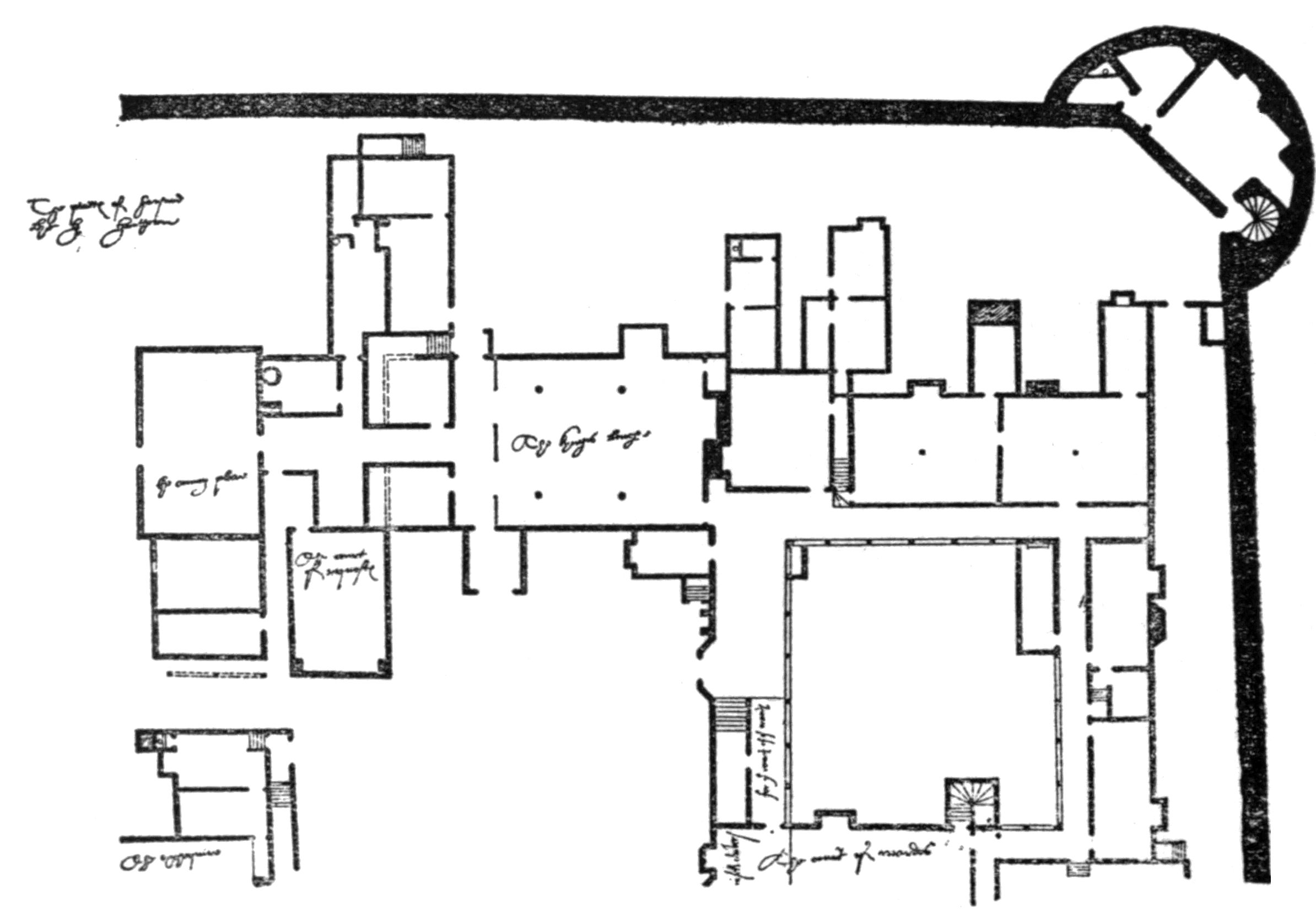
Fig. 59.—GROUND PLAN, HERTFORD.
From the
Public Record Office.
The plan, unfortunately mutilated, is the work of H. Hawthorne, who was also employed upon the alterations to Windsor in the early part of Elizabeth’s reign.
Hertford Castle in its early days was evidently a place of considerable strength and importance, for when besieged in 1216 by the forces of Louis of France it held out for twenty-four days, while the neighbouring castle of Berkhampstead (the elaborate earthworks of which remain) was reduced by the same army in a fortnight.
Hertford was the occasional residence of the later Plantagenet and Tudor kings, and was successively held in dower by the consorts of the three Lancastrian sovereigns. Later it was found to be a convenient residence for the children of Henry VIII.—Edward, Mary, and Elizabeth having all resided there at various times during their father’s life.
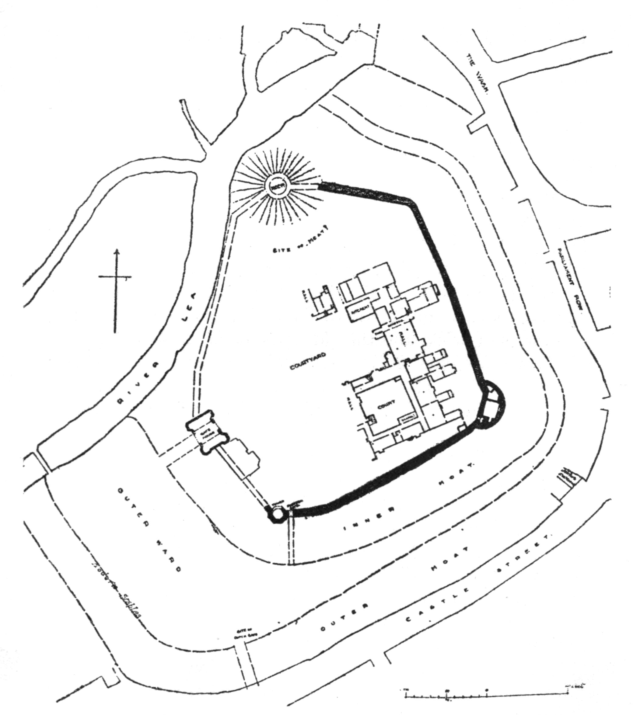
Fig. 60.—PLAN OF FORTIFICATIONS.
Drawn by
A. W. Clapham.
Five documents in the nature of surveys of the castle exist at the Record Office, dated respectively 1327, 1523, 1559, 1589 and 1610. The first of these is the most interesting. The castle then consisted of a great inner ward surrounded by a double moat with a circular shell keep at the north-east angle, and a massive curtain wall. The narrow space between the inner and outer moats was defended by a wooden palisade, and at the western end broadened out into a large outer ward.
Henry VIII.’s survey describes “a fair river running along by the north side of the said castle and arear a very little garden ground, but there is a fair courtyard and large, which is almost finished round about with fair houses.”
By 1610 most of the buildings had been destroyed, and mention is only made of “one fair gatehouse of brick, one tower of brick, and the old walls of the said castle.”
This represents fairly accurately the present condition of the castle. The brick gatehouse, though somewhat altered, is still entire, the outer archway being obscured by a modern porch, while the inner one is converted into a window. Above the former is a sunk panel with the royal arms of the Tudors surmounted by a crown. The “tower of brick” is the great angle bastion shown on the plan. It formed the segment of a circle externally about 60 ft. in diameter, the chord of which is a brick wall which is the only portion of the structure now standing. On the outer face at the southern end are the remains of the circular stair, including a ramped portion of the brick handrail sunk in the wall.
The most noticeable feature of the plan is the extreme thinness of the walls. This can hardly be ascribed to faulty draughtsmanship, as the curtain and bastion walls, together with the fireplace backs, are all shown of reasonable thickness. One is bound to conclude that the whole structure was timber-framed on dwarf walls, the remains of which have from time to time come to light under the present lawn. This would largely account for the continual state of disrepair in which the buildings are found on every occasion on which there is evidence of their condition.
On the east side of the great courtyard, opposite the gatehouse, stood the hall, a comparatively small building of very early type. The aisled hall is now to be found only in comparatively few instances (as at Oakham and Winchester Castle) and is almost certainly a survival of the Saxon type of wooden structure whose form has been preserved in use almost to our own times in the great timber barns, of which there are numerous examples. The contemporary Norman type is preserved at Richmond, Wolvesley, and Christchurch, and in a number of monastic frater-houses, and was a plain rectangular structure of quite a different character. (Vide ante p. 70.)
The hall at Hertford was only three bays long, with screens and two porches at the northern and a square oriel at the southern end. One large fireplace appears at the back of the dais, and a small lantern in the centre of the roof is shown on Speed’s bird’s-eye view of the town (probably taken just before its destruction, 1610).
The lesser court on the south side was probably of early Tudor date, and evidently had galleries on the first floor with projecting bays, an arrangement similar to that of the second quadrangle of Queen’s College, Cambridge. At the south-eastern angle was a small building projecting into the court and clearly a chapel or oratory.
The arrangement of the kitchen and offices at the north end of the great hall is by no means clear. The only apartment with a fireplace of sufficient dimensions for the kitchen is that marked “Court of Requests,” but the lack of direct communication with the hall itself renders this identification doubtful. In spite of its lack of completeness and the difficulty surrounding it, the plan is of considerable interest both on account of its early form and the importance of the building which it delineates.
The Manor, Palace, or Bower of Havering was, like Hertford, of Saxon origin, but its early history is of far greater interest. It was undoubtedly a retreat of King Edward the Confessor, and some of the best-known legends of the Saxon saint are connected with the Bower House. You may read in Caxton’s Golden Legend of how St. John the Divine appeared in the form of a beggar at the consecration of his chapel here, and of how he received the celebrated ring as alms from the king. It was here, again, at the prayer of the Confessor the nightingales were banished without the pales of the park, lest they should interrupt the royal devotions.
In later times it was a favourite hunting seat for the forest of Hainault, and a long line of Chief Foresters of Essex—Mountfitchets, de Clares, and de Veres—held the office of keeper of the park of Havering.
The place is also closely connected with the history of Richard II.’s treacherous seizure of his uncle Gloucester at Pleshy. It was from Havering he set out to decoy the doomed man from the midst of his family to hurry him to Calais and his death.
During Tudor times the palace, with the neighbouring house of Pyrgo, fell gradually into disuse and disrepair, and a visit of Charles I. in 1637 is the last recorded occasion on which Havering received a royal guest. In the time of the Commonwealth, some twelve years later, we find it described as “being a confused heape of old, ruinous and decayed buildings” of value only as materials. Since that time the destruction has gone on till now no fragment of the old building survives.
The situation of Havering Palace is amongst the most beautiful round London. Some three miles north of Romford, it once crowned a rounded hill about 300 ft. high commanding an extensive view, and was surrounded by a park of 1,311 acres, many of the noble trees of which yet line the lanes and hedgerows of the country-side. The quiet village, with its broad green and ancient stocks, has the unusual merit of being not only entirely unspoiled but almost untouched by the modern builder. The royal demesnes of the Bower and Pyrgo are still represented by the great parks and seats which hem the village in on every side.
The plan of the ancient palace is preserved in its entirety in two drawings here reproduced—one showing the kitchen court and offices and published as long ago as 1814 in Ogborne’s “History of Essex,” and the second, from the Hatfield MSS., now printed for the first time, showing the main block of the palace buildings. The old royal manor-house was chiefly remarkable for its extreme irregularity, and it is difficult to determine its original form.
It is obviously a building of many dates and the subject of many additions and alterations. The windows of the smaller or private chapel with the bold buttresses appear to be indicative of a thirteenth-century building, while the wooden galleries and stairs are no doubt of Tudor date.
Most of the buildings shown are on the first-floor level. “The Presence Chamber” (40 ft. by 22 ft.) may be taken to represent the original hall with the screens at the west end. Running south from the dais end is “The Great Chamber,” a large apartment (originally 61 ft. by 24 ft.) communicating on the south with the Great Chapel (45 ft. by 16½ ft.) used by the parish and dedicated, in reference to King Edward’s adventure, to St. John the Evangelist.
This building was claimed by the tenants, at the time of the Commonwealth, as the parish church, on the grounds that they had used it time out of mind and, furthermore, that there was another chapel within the palace. They apparently gained their point, and the old edifice remained in part until the erection of the present building.
The plan shows a rectangular structure of three bays, the western one being occupied by the Royal Pew approached by a wooden staircase.
A view of this building, much altered, is given in Ogborne’s “Essex,” from which it appears to have been of fifteenth-century date and to have retained the timber annexe at the western end shown upon the plan.
The modern church which has now replaced it contains a square twelfth-century font and some leger-stones said to have come from the chapel of Pyrgo Palace long ago destroyed. It stands approximately on the site of its predecessor, and is consequently of value in determining the precise site of the palace buildings, which extended to the north-west, the Privy Garden adjoining Havering Green upon the west.
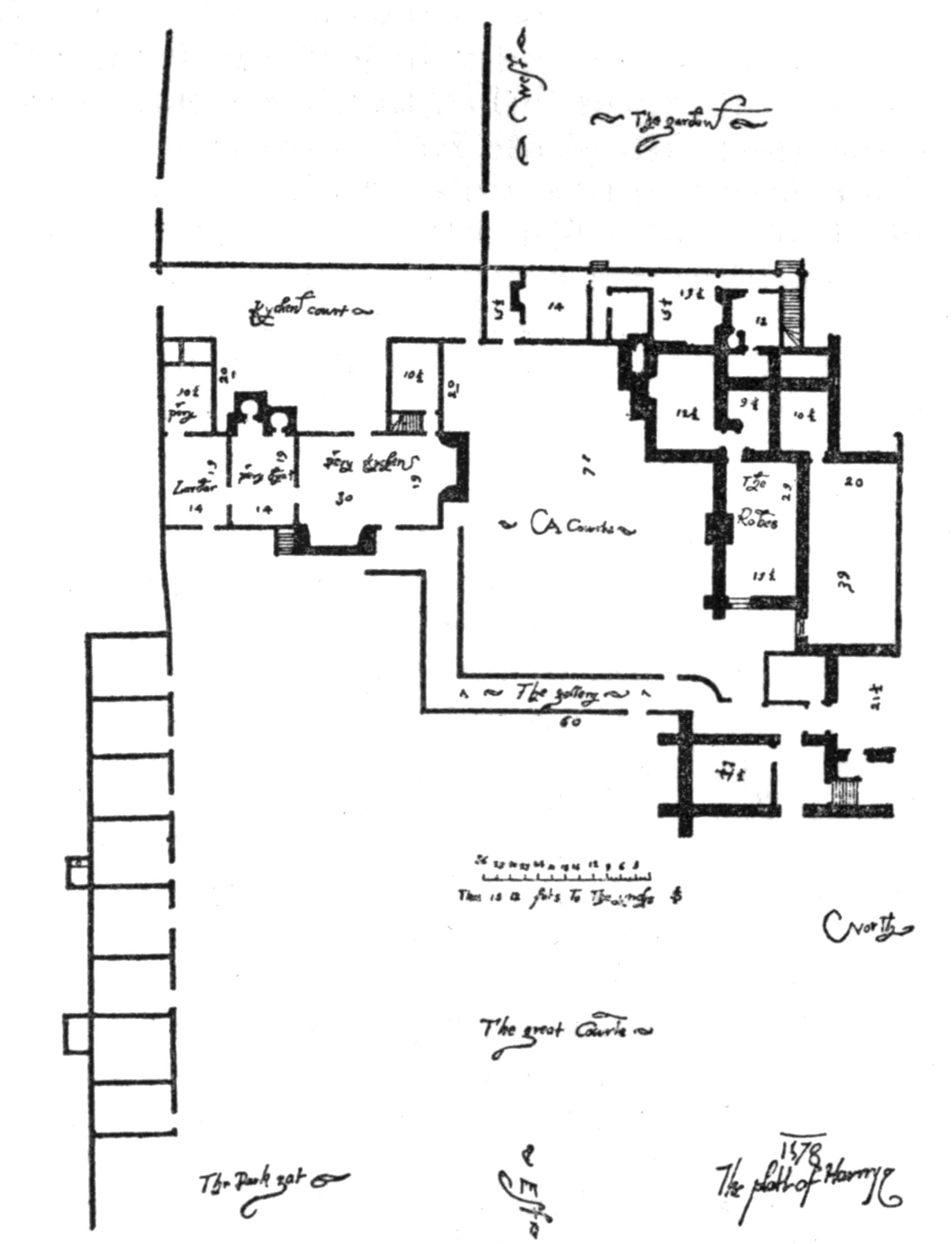
Fig. 61.—HAVERING, GROUND PLAN.
From the
British Museum.
The Second or Private Chapel adjoins the south-west corner of the hall, and is shown in considerable detail. It was lit by four or five windows in the south wall and a trio of lancets with detached shafts at the west end, the whole building being only 32½ ft. by 14 ft.
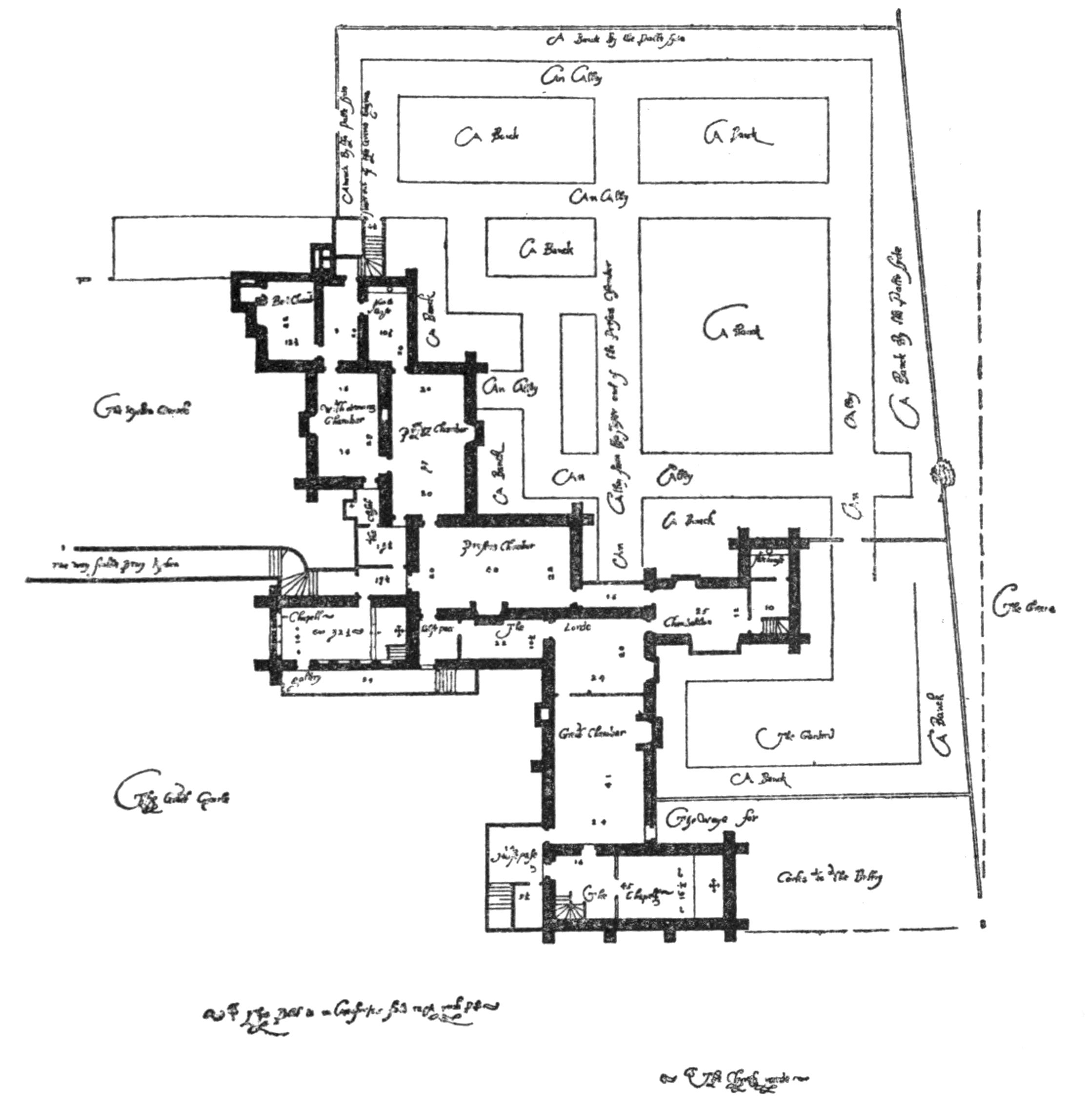
Fig. 62.—HAVERING, FIRST FLOOR.
From the
Hatfield MSS.
The large block of buildings lying to the north of the Great Hall formed the private apartments of the sovereign and are called “the Queen’s Lodging.” They consist of a privy chamber, withdrawing chamber, bedchamber, closet, and two other apartments, with a private stair leading to the garden.
To the west of this range lay the courts and offices shown upon the second plan. (The original is said to be in the Lansdowne MSS. in the British Museum.) They include the privy kitchen and larder with a small court adjoining, with a long range of timber lodgings stretching southwards, and some of the ground-floor apartments of the main block being also indicated. The whole group forms an example of a large domestic plan of distinctively early type, uninfluenced by any considerations of military defence, and can only be paralleled by the buildings of old Westminster Palace.
The two plans are by the same hand, although the scales differ, for both are signed J. S., presumably standing for John Symonds, the well-known Elizabethan draughtsman, and the second is furthermore named and dated 1578 in Lord Burghley’s hand.
—A. W. C.
THE NEW EXCHANGE IN THE STRAND
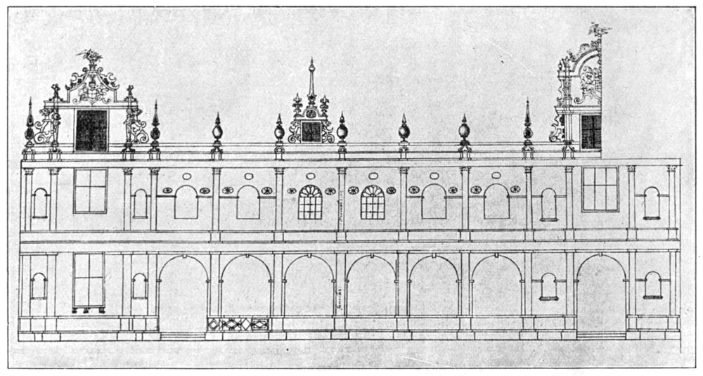
Fig. 63.—ELEVATION OF BUILDING (c. 1610).
Drawn by
Smithson.