INDEX.
Reading edition
Abbott, Mr., 62
Abies amabilis, 102
Canadensis, 100
concolor, 101
Douglasii, 100
Engelmanni, 101
grandis, 102
Menziesii, 101
subalpina, 101
Acer grandidentata, 103
Agricultural and timber industries differentiated, 18
resources of the Bear River drainage basin, 119
Jordan River drainage basin, 124
Weber River drainage basin, 121
Agriculture, Amount of precipitation necessary for, 2, 3
Influence of temperature upon, 2
in the Arid Region dependent upon irrigation, 40
in Utah dependent upon irrigation, 6
exceptions thereto, 6
limited by several conditions, 7
Utilization of the small streams in, 7
without irrigation, 3, 6, 50
Aira cœspitosa, 109
Alabama, Land-grants to, 179
Alkaline salts, 145
Amount of land a unit of water will supply, 7
Antelope Island, 63, 64
bar, 63, 67
Areal distribution of rainfall, 82
Area of irrigable land sometimes not limited by water supply, 85
Areas of standing timber, 15
to which larger streams can be taken, 7
which smaller streams can serve, 7
Arid Region, Boundaries of the, 1, 3
Extent of the, 5
Increase in water supply in the, 89, 91
Land system needed for the, 25
Mining industries of the, 88
Physical characteristics of the, 1
Precipitation of the, 48
Rainfall of the, 5
Arizona and New Mexico, Seasonal precipitation in, 56
Arkansas, Land grants to, 174, 179
Artemisia, 110
Ashley Fork, Irrigable lands of, 161
Atchison, Topeka and Santa Fé Railroad Company, Land grants to the, 178
Atlantic and Pacific Railroad Company, Land grants to the, 179
Atlantic coast, Flow of the rivers of the, 76
Rainfall on the, 69
Barfoot, Mr. J. L., 59
Barton, Mr., 113
Basin, Colorado. (See Colorado Basin.)
Great Salt Lake. (See Great Salt Lake District.)
Range System, 94
Sevier Lake. (See Sevier Lake District.)
Uinta-White. (See Uinta-White Basin.)
Bear River, 117
City, 78
drainage basin, Agricultural resources of the, 119
Area of the, 119
Mean flow of the, 72
Beaver dams, Effect of cutting, 74
Betula occidentalis, 103
Bill to authorize the organization of irrigation districts, 30
pasturage districts, 33
Black Rock bench, 61
pillar, 59, 60
Bonneville Lake, 96
Book Cliffs, Orographic structure of the, 98
Bouteloua oligostachya, 108
Bromus, 109
Brown Cliffs, 98
Brown’s Park, Irrigable lands of, 162
Burlington and Missouri Railroad Company, Land grants to the, 178
Canals, Land grants in aid of, 166
Cañon Lands, Amount of irrigable land in the, 106
Coal lands of the, 106
Description of the, 105
of Utah, 94
Carex Jamesii, 109
Carrington Island, 62
Castle Valley, 105
Central Pacific Railroad Company, Land grants to the, 177
Cercocarpus parvifolius, 110
Celtis occidentalis, 103
Circle Valley, Amount of irrigable land in the, 137
Climate of the Colorado Basin, 151
Coal lands, 45
Disposal of the, 44
of the Cañon Lands, 106
of the Rocky Mountain Region, 19
Colony system, 28
Colorado Basin, Climate of the, 151
Elevation of the, 151
Irrigable lands of the, 150
Mean annual precipitation in the, 79
Orographic structure of the, 95
Source of the water supply of the, 152
Table of irrigable lands of the, 164
drainage area, 94
River, Principal tributaries of the, in Utah, 150
Conditions affecting the distribution of rainfall, 90
Coöperative labor necessary to the development of irrigation, 11
Critical period, 85, 138, 154
season, 116
Dakota, Precipitation of, 51
Denver Pacific Railroad Company, Land grants to the, 179
Desert drainage area, 94
Orographic structure of the, 95
Des Moines River, Land grant in aid of the improvement of the, 171
Distribution of rain throughout the year, 50
District, Great Salt Lake. (See Great Salt Lake District.)
Sevier Lake. (See Sevier Lake District.)
Division lines of pasturage farms, 22, 28, 37
of land by settlers, 38
Drainage area, Colorado, 94
Desert, 94
Modification of the conditions of, 73
of the Tavaputs Plateau, 96
Uinta Mountains, 96
Wasatch Mountains, 96
Utah, 94
Drummond, Willis, jr., on land grants in aid of internal improvements, 164
Dry farming, 50, 78
Duchesne River, Volume of flow of the, 160
Dutton, Capt. C. E., cited, 110
on the irrigable land of the Sevier Basin, 128
East Florida Railroad Company, Land grant to the, 169
Egg Island, 67
Engelmann, Mr., 102
Erocoma cuspidata, 108
Escalante River, Irrigable lands of the, 156
Volume of flow of the, 156
Eurotia lanata, 110
Evaporation by spreading of water, 74
Farmington pillar, 61
Farming without irrigation, 77
Farm residences, Grouping of, 22
unit for pasturage lands, 21, 28
Fencing of pasturage lands, 23
Fires in the timber region, 15, 99
Cause of, 17, 99
Protection from, 18, 99
Flood-plain lands, 88
Forests, Amount of rainfall necessary to the growth of, 15
Fox, Mr. Jesse W., 61, 113
Fraxinus anomala, 103
coriacea, 103
Fremont Island, 62, 67
River, Irrigable lands of the, 157
Tributaries of the, 157
Volume of flow of the, 157, 158
Gilbert, G. K., cited, 84, 110
on irrigable land of the Salt Lake drainage system, 113
on water supply, 57
Government right to use of subsidized railroads, 181
Grand River, Irrigable lands of the, 163
Volume of flow of the, 163
Grasses of the pasturage lands, 19
Utah, 107
Great Salt Lake, Accumulation of the water in, 58
Area of, 66, 73
Basin (See Great Salt Lake District)
Causes of abnormal change of, 67
Desert, 66
Diagram showing rise and fall of, 64
District, 94
Amount of irrigable land in the, 107
Change in the climate of the, 68, 70
Description of the, 107
Irrigable lands of the, 113
Fluctuations in the rainfall of the, 70
Irrigation by large streams in the, 117
small streams in the, 126
Evaporation of the water of, 58, 72
History of the past changes of, 62
Increase and decrease of the size of, 58
Islands of, 62
Limited oscillation of, 59
Limit of wave action of, 65
Record of height of, 60
Rise and fall of, 59
Storm lines of, 65
Streams flowing into, 72
Green River, Irrigable lands of the, 162
Volume of flow of the, 162
Gunnison, Captain, 98
Valley, 105
Irrigable lands of the, 163
Hayden, Dr. F. V., 71
Henry Mountains, 105
Prof. Joseph, 46, 59, 62, 79
Henrys Fork, Irrigable lands of, 161
Illinois, Land grants to, 168, 172
Increase in water supply in the Arid Region, 57, 89, 91
of rainfall, 69, 91
Indiana, Land grants to, 166, 167
Internal improvements, Land grants in aid of, 165
Iowa, Land grants to, 169, 179
Irrigable and pasturage lands of Utah, 104
areas, Increase of, by storage of water, 12, 13
land, Area of, sometimes not limited by water supply, 85, 86
Extent of, increased by the use of springs, 9
in Utah, Amount of, 9
lands, 23
Amount of water required for, 84
Disposal of, 27
highly productive, 10
Important questions relating to, 81
Increase in the extent of the, 57
in Utah Territory, Table of, 111
of Southwestern Utah, 148
of the Colorado Basin, 150
Table of, 164
Great Salt Lake District, 113
Sevier Lake District, 134
valley of the Sevier River, 128
Irrigable lands of the, Virgin River, 153
of Utah, Distribution of the, 9
Selection of, 87
Situation of the, 6
Irrigating canals, Cost of, 125
methods, Improvement in, 8
season, 85
Irrigation, Advantages of, 10
Amount of water needed for, 114
used in, 141
companies, 40
Coöperative labor necessary to the development of, 11
Direct influence of, upon the inflow of Great Salt Lake, 75
Indirect influence of, upon the inflow of Great Salt Lake, 76
of pasturage farms, 21
Quantitative value of water used in, 81
Unit of water used in, 81
Isohyetal line of twenty inches, 2
Jordan River, 121
drainage basin, Agricultural resources of the, 124
Area of the, 125
Mean flow of the, 72
Juncus Balticus, 109
Juniperus Californicus, 103
Virginiana, 103
Kanab Creek, Irrigable lands of, 154
Ponding of, 154
Kansas, Land grants to, 178, 179
Pacific Railroad Company, Land grants to the, 177
Kimball, Mr. Heber P., 61
King, Mr. Clarence, 66
Lake Bonneville, 96
Utah, Function of, as a reservoir, 123
Land grants in aid of internal improvements, 165
Lands, Classification of, 43
Irrigable. (See Irrigable Lands.)
of Utah, 93
and Idaho fertilized by water, 75
Physical features of the, 93
Pasturage. (See Pasturage Lands.)
Land system needed for the Arid Region, 25
Leavenworth, Lawrence and Galveston Railroad Company, Land grants to the, 178
Lower Columbia Region, 1
Precipitation of the, 49
Marshes, Drainage of, 74
Evaporation from, 74
Martineau, Mr. J. H., 113
Mean temperature by seasons for the San Francisco Region, 54
Method of determining the supply of water, 85, 86
Michigan, Land grants to, 179
Miller, Mr. Jacob, 61, 62
Mineral lands, 44
Disposal of, 44
not suited to agriculture, 44
Minnie Maud Creek, Irrigable lands of, 160
Volume of flow of, 160
Minnesota and Northwestern Railroad Company, 176
Land grants to the, 174, 179
Mississippi Valley, Flow of the rivers of the, 76
Missouri, Kansas and Texas Railroad Company, Land grants to the, 178
Land grants to, 179
Mitchell, Mr. John T., 59
Monopoly of pasturage farms, 22
Mountains, Henry, 105
Uinta. (See Uinta Mountains.)
Wasatch. (See Wasatch Mountains.)
Negundo aceroides, 103
Nevada, Mean annual precipitation in, 79
New Mexico and Arizona, Seasonal precipitation in, 56
New Orleans and Nashville Railroad Company, Land grants to the, 168
New York, Rainfall of the State of, 70
Ogden River, Measured volume of the, 120
Ohio, Land grants to, 166, 167
Ohio Valley, Rainfall of the, 70
Orographic structure of the Book Cliffs, 98
Colorado drainage area, 95
Desert drainage area, 95
Uinta Mountains, 97
Wasatch Mountains, 96
Pacific coast, Seasonal precipitation and temperature of the, 55
Panguitch Valley, Amount of irrigable land in, 136
Paria River, Irrigable lands of the, 155
Volume of flow of the, 155
Park, Dr. John R., 59
Pasturage farms, Division lines of, 22, 28, 37
Irrigation of, 21
need small tracts of irrigable land, 21, 28
lands, 19, 24, 104
Pasturage lands, Boundaries of, 19
Disposal of, 28
Extent of, 19
Farm unit for, 21, 28
Fencing of, 23
Grasses of the, 19
Monopoly of the, 22
partially supplied by scattered springs, 21
Situation of the, 6
Phragmites communis, 109
Pinus aristata, 100
edulis, 100
flexilis, 100
monticola, 100
ponderosa, 100
Pioneers, Enterprise and industries of, 41
Plateaus, The High, 94
Plateau, Tavaputs, 93
Yampa, 105
Poas, 108
Ponding, 12, 13
Ponds, Evaporation of the water of, 73
Populus angustifolia, 102
monilifera, 102
tremuloides, 102
Precipitation in the Region of the Plains, 52
Mean annual, in Colorado, 79
Nevada, 79
Utah, 79
Wyoming, 79
north of the Columbia River, 1
of Dakota, 51
Texas, 50
the Arid Region, 48
Region of the Lower Columbia, 49
San Francisco Region, 49
Sub-humid Region, 47
Precipitation, Seasonal, of the Pacific Coast, 55
Price River, Irrigable lands of the, 159
Volume of flow of the, 159
Provo River, 121
Public lands, How to acquire title to, 25
Quercus undulata, 103
Railroads, Land grants in aid of, 165, 168, 172
Rainfall, Areal distribution of, 82
Conditions affecting the distribution of, 90
Rainfall, Distribution of, throughout the year, 50
Increase of, 91
of the Arid Region, 5, 48
belt between Great Salt Lake and Wasatch Mountains, 6, 79
Sub-humid Region, 4, 47
of the western portion of the United States, 46
Rain gauge records, 1, 3, 91, 131
Deficiency of, 1
“Rainy seasons”, 25, 50
Ranges, Basin, 94
Records, Rain gauge, 1, 3, 91, 131
Region of the Lower Columbia. (See Lower Columbia Region.)
of the Plains, Seasonal precipitation in the, 52
San Francisco. (See San Francisco Region.)
Sub-humid. (See Sub-humid Region.)
Renshawe, Mr. J. H., 113, 153
Reservoirs, 12, 13, 85, 144
River, Bear. (See Bear River.)
Colorado. (See Colorado River.)
Duchesne. (See Duchesne River.)
Escalante. (See Escalante River.)
Fremont. (See Fremont River.)
Grand. (See Grand River.)
Green. (See Green River.)
Gunnison. (See Gunnison River.)
Jordan. (See Jordan River.)
Ogden. (See Ogden River.)
Paria. (See Paria River.)
Price. (See Price River.)
Provo. (See Provo River.)
San Rafael. (See San Rafael River.)
Sevier. (See Sevier River.)
Uinta. (See Uinta River.)
Virgin. (See Virgin River.)
Weber. (See Weber River.)
White. (See White River.)
Rivers, Land grants in aid of improvement of, 169
Rockwood, Hon. A. P., 113
San Francisco Region, Mean temperature, by seasons, of the, 54
Precipitation of the, 49
Rainy season of the, 54
Seasonal precipitation in the, 53
San Pete Valley, Amount of irrigable land in the, 138
Flow of the streams of the, 138
San Rafael River, Irrigable lands of the, 158, 159
Tributaries of the, 158
San Rafael River, Volume of flow of the, 159
Schott, Mr. Charles A., 46, 69
Seasonal precipitation and temperatures on the Pacific coast, 55
in Arizona and New Mexico, 56
Seasonal precipitation in the Region of the Plains, 52
San Francisco Region, 53
Selection of irrigable lands, 87
Sevier Lake Basin, 94
District, 94
Altitudes in the, 133
Amount of irrigable land in the, 106, 143
Climate of the, 131
Description of the, 106
Irrigable lands of the, 134
Physical characteristics of the, 130
Rainfall of the, 131
Rain gauge records of the, 131
River, Course of the, 129
Volume of flow of the, 139, 140
Irrigable lands of the valley of the, 128
Valley of the, 129
Sierra La Sal, 105
Sioux City and Pacific Railroad Company, Land grants to the, 177
Smithsonian Tables of Precipitation, 46, 69
Soil and subsoil, Complicating conditions of, 83
Conditions of, 82
Soils, 145
Southern Pacific Railroad Company, Land grants to the, 179
Springs, Opening out of, 74
Use of, in irrigation, 9
Stansbury, Captain Howard, 64, 65, 66
Island, 67
bar, 64, 67
Streams, Descent of, 88
flowing into Great Salt Lake, 72
Flow of, at different periods, 13
Increase in the volume of, 57
Measurement of, 86, 115
of San Pete Valley, Volume of flow of the, 140
of Utah, Fluctuations of the, 115
Practical capacity of, 85
small, Employment of, in irrigation, 7, 11, 12
Strong’s Knob, 67
Sub-humid Region, Boundaries of the, 3
destitute of forests, 4
Mean precipitation of the, 47
Rainfall of the, 4
Supply of water, Method of determining the, 85, 86
Table I. Precipitation of the Sub-humid Region, 47
II. Arid Region, 48
III. San Francisco Region, 49
IV. Region of the Lower Columbia, 49
V. Texas, 50
VI. Dakota, 51
VII. Season of precipitation in the Region of the Plains, 52
VIII. San Francisco Region, 53
IX. Mean temperature, by seasons, for the San Francisco Region, 54
X. Seasonable precipitation and temperatures on the Pacific coast, 55
XI. in Arizona and New Mexico, 56
of irrigable lands in Utah, 111
of southwestern Utah, 149
of the Colorado Basin, 164
Sevier Lake District, 144
of mean annual precipitation in Colorado, 79
Nevada, 79
Utah, 79
Wyoming, 79
Tavaputs Plateau, 93
Drainage of the, 96
Temperature dependent upon altitude and latitude, 2
Temperatures, Seasonal, on the Pacific Coast, 55
Texas and Pacific Railroad Company, Land grants to the, 179
Precipitation of, 50
The High Plateaus, 94
Thomas, Prof. Cyrus, 71
Thompson, Prof. A. H., cited, 86, 110
on the irrigable land of the Colorado Basin, 150
Timber, 98
Areas of standing, 15, 17
Cultivation of, 19
Destruction of, by fire, 15
growth dependent upon climatic conditions, 14
lands, 14, 23
Boundaries of the, 14
Disposal of the, 27
Situation of the, 6, 14
regions, 15
Extent of the, 16
Fires in the, 15, 17, 18, 99
Titles to public lands, 25
Uinta Mountains, 93
Drainage of the, 96
Orographic structure of the, 97
Uinta River, Irrigable lands of the, 160
Tributaries of the, 160
Volume of flow of the, 160, 161
White Basin, 93
Amount of irrigable lands in the, 105
Description of the, 104
Physical features of the, 160
Union Pacific Railroad Company, Land grants to the, 177
Unit of water supply, 8, 84, 115, 141
Method of determining the, 8
used in irrigation, 81
Utah, Amount of cultivated land in, 84
Church government in, 89, 128
Drainage of, 94
Forest trees of, 100
Grasses of, 107
Irrigable and pasturage lands of, 104
Lake, 123
Lands of, 93
Mean annual precipitation in, 79
Pasturage lands of, 104
Prevailing winds of, 68
Table of irrigable lands in, 111
Timber of, 98
Variety of crops cultivated in, 84
Watershed of, 94
Valley, Castle, 105
Circle, Amount of irrigable land in the, 137
Gunnison, 105
Irrigable lands of the, 162
of the Mississippi, 76
Sevier River, Amount of irrigable land in the, 144
Panguitch, Amount of irrigable land in the, 136
San Pete, Amount of irrigable land in the, 138
Flow of the streams of the, 140
Vasey, Dr. George, 108
Vilfa (Sporobolis) airoides, 108
Virgin River, Irrigable lands of the, 153
Volume of water flowing in the streams, Determination of, 8
Wagon roads, Land grants in aid of, 166
Ward, Mr. L. F., 103
Wasatch Mountains, 93, 94
Drainage of the, 96
Orographic structure of the, 96
Wastage of water, 84
Water, Evaporation of, 13
Irrigating capacity of, 8, 84, 115, 141
Loss of, by evaporation, 87
Method of determining the supply of, 85, 115, 139
storing, 12
rights, 40
should inhere in the lands to be irrigated, 40, 41
supply, 57
affected by the cutting of timber, 75
farming, 73
grazing, 74
Economic bearings of the, 76
Increase in the, 57, 89, 91
Storage of, 116, 125, 144
used in irrigation, Quantitative value of, 81
Unit of, 81
Wastage of, 84, 142
ways rudely constructed, 8
Weber River, 119
drainage basin, Agricultural resources of the, 121
Area of the, 121
Mean flow of the, 72
White River, Irrigable lands of the, 162
Volume of flow of the, 162
Winds of Utah, 68
Wisconsin, Land grants to, 169, 179
Wyoming, Mean annual precipitation in, 79
Yampa Plateau, 105
Young, Hon. Brigham, 105
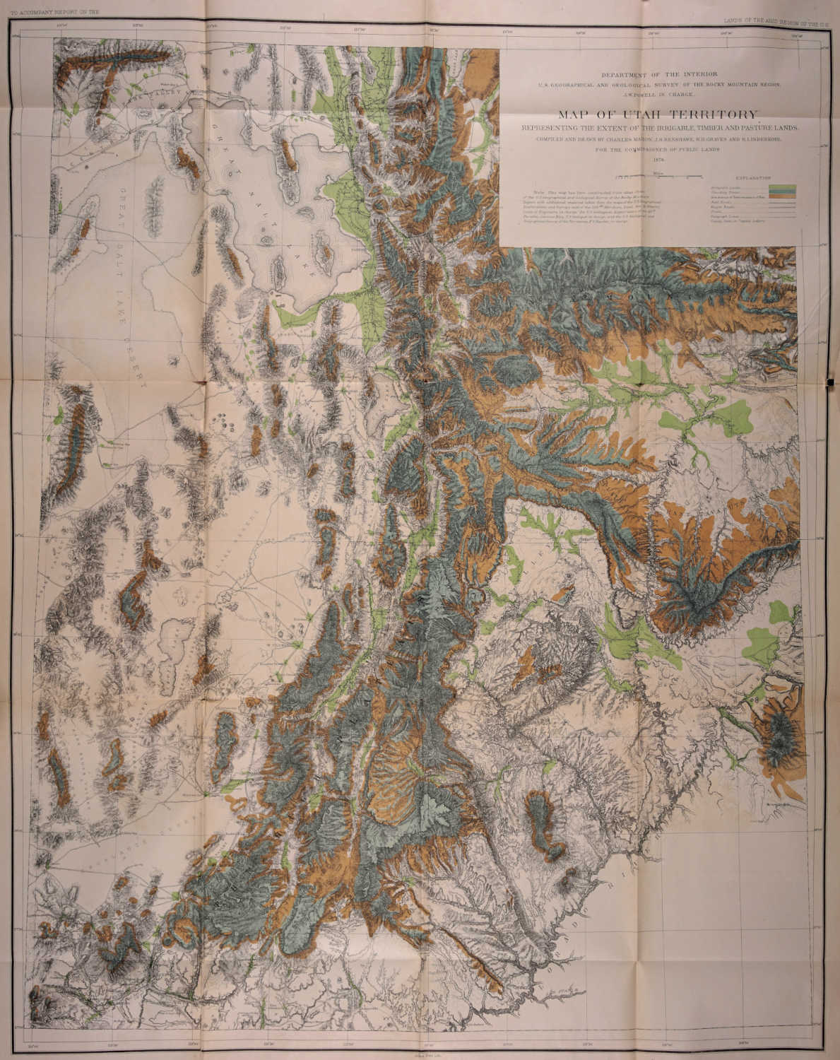
DEPARTMENT OF THE INTERIOR
U. S. GEOGRAPHICAL AND GEOLOGICAL SURVEY OF THE ROCKY MOUNTAIN REGION, J. W. POWELL IN CHARGE.
MAP OF UTAH TERRITORY REPRESENTING THE EXTENT OF THE IRRIGABLE, TIMBER AND PASTURE LANDS.
COMPILED AND DRAWN BY CHARLES MAHON, J. H. RENSHAWE, W. H. GRAVES AND H. LINDENKOHL FOR THE COMMISSIONER OF PUBLIC LANDS
1878.
Miles
Note This map has been constructed from atlas sheets of the U. S. Geographical and Geological Survey of the Rocky Mountain Region with additional material taken from the maps of the U. S. Geographical Explorations and Surveys west of the 100ᵈᵗʰ Meridian, Lieut. Geo. M. Wheeler, Corps of Engineers, in charge, the U. S. Geological Exploration of the 40ᵗʰ Parallel, Clarence King, U. S. Geologist in charge, and the U. S. Geological and Geographical Survey of the Territories, F. V. Hayden, in charge
EXPLANATION
Irrigable Lands Standing Timber Area destitute of Timber on account of Fires Rail Roads Wagon Roads Trails Telegraph Lines County Seats in Capital Letters.
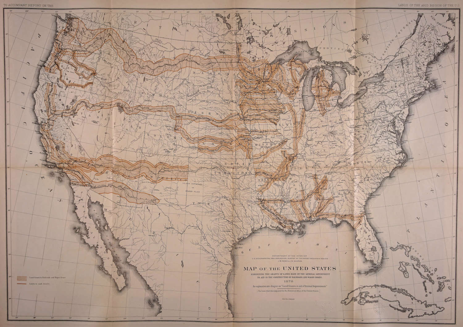
DEPARTMENT OF THE INTERIOR U.S. GEOGRAPHICAL AND GEOLOGICAL SURVEY OF THE ROCKY MOUNTAIN REGION J. W. POWELL, IN CHARGE.
MAP OF THE UNITED STATES
EXHIBITING THE GRANTS OF LANDS MADE BY THE GENERAL GOVERNMENT TO AID IN THE CONSTRUCTION OF RAILROADS AND WAGON ROADS.
1878
For explanation see chapter on “Land Grants in aid of International Improvements”
[The base chart was engraved for the Statistical Atlas of the United States.]
Julius Bien. Lithographer