OBSERVATIONS ON THE GEOLOGY, ZOOLOGY AND BOTANY OF HUDSON’S STRAIT AND BAY,
Reading edition
MADE IN 1885.
BY ROBERT BELL, B.A.Sc., M.D., LL.D., F.R.S.C.
PUBLISHED BY AUTHORITY OF PARLIAMENT.
MONTREAL: DAWSON BROTHERS. 1885.
Ottawa, April, 1886.
To Alfred R. C. Selwyn, Esq., LL.D., F.R.S., F.G.S.,
Director of the Geological and Natural History Survey of Canada.
Sir,—I beg to submit, herewith, my report as Geologist and Naturalist on the Second Expedition to Hudson Strait and Bay, sent out by the Government of Canada on board the steamship “Alert” in 1885.
I have the honour to be, Sir, Your obedient servant, ROBERT BELL.
OBSERVATIONS ON THE GEOLOGY, ZOOLOGY, AND BOTANY OF HUDSON’S STRAIT AND BAY,
MADE IN 1885. BY ROBERT BELL, B.A.Sc., M.D., LL.D., F.R.S.C.
My preliminary report, of December, 1885, gave a general account of the field-work of the year, and a narrative of the Second Hudson’s Bay Expedition by the steamship “Alert,” as far as the geological and biological work are concerned. I purpose, therefore, in the following pages, to confine my remarks to a fuller description of the results in these departments. These were, unfortunately, very limited, owing to the fact that most of our time was spent either at sea or in the ice, or in relieving the stations, which I had already visited on the “Neptune” expedition of the previous year, and had done as much geological work as possible in their neighborhoods. A month in the middle of summer, was also consumed in our voyage from the Straits to St. John’s, Newfoundland, and back again, after the “Alert” had there undergone some necessary repairs.
Botanical collections.
Entomological collections.
Birds, mammals and fishes.
Botanical specimens were again collected at all places visited. Collections of plants had also been made by some of the observers at the stations before the arrival of the “Alert.” Although the number of specimens obtained is quite large, yet only five species can be added to the list of 1884. In the appendix to the present report will be found a catalogue, by Prof. Macoun, of the plants collected while we were in Newfoundland. I am indebted to Major H. H. Lyman, of Montreal, for having prepared the accompanying list of the Lepidoptera, and some other insects collected last year by myself and Messrs. H. M. Burwell and Arthur Laperrière. The Coleoptera have been kindly examined by Mr. W. H. Harrington. A number of specimens of birds, mammals and fishes were collected during the voyage, or obtained from some of the observers, especially Mr. Laperrière, who was in charge of the station at Cape Digges. I am indebted to Dr. Mathews, of York Factory, for additional specimens of birds, and to Mr. J. R. Spencer, of Churchill, for specimens of Back’s grayling, and other fishes. After the zoological specimens shall have been critically examined, complete lists of them, along with those obtained around Hudson’s Bay in previous years, will be published. I have much pleasure in acknowledging the kindness of the Right Revd. Charles Guay, of Cross Point, P.Q., in procuring canoes and endeavouring to hire Indians for the expedition. Mr. James MacNaughton, M.A., acted as my assistant during the season.
Report furnished the Department of Marine.
It was considered desirable that the Report of the “Alert” Expedition, to be published by the Department of Marine, should contain an account of the geology of Hudson’s Bay and the surrounding country; and accordingly, with the approval of the director, a report on this subject has been furnished. It embraces not only the general results of the geological observations of the “Neptune” and “Alert” expeditions of 1884 and ’85, but also of the previous expeditions around Hudson’s Bay, made principally on the east side, in 1875 and ’77, and on the west side in 1878, ’79 and ’80, and in the interior in 1870 and ’71. A chapter on the Economic Minerals of the Hudson’s Bay Territories generally, is also included in the above Report.
As all matters concerning ice, ocean currents, soundings, tides, meteorological phenomena, etc., belong to Lieut. Gordon’s province, and will be fully reported on by him, I shall not allude to them except in their relation to geological questions.
British American Bank Note Co. Montreal
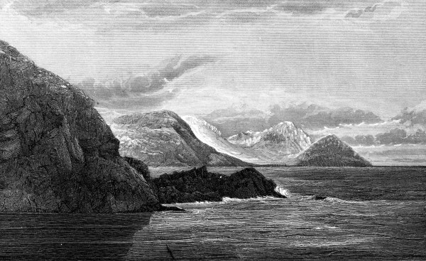
NORTH SIDE OF ENTRANCE TO NACHVAK INLET. LABRADOR.
SHOWING THE STEEP AND UNGLACIATED CHARACTER OF THE MOUNTAINS.
Voyage from Halifax to Hudson’s Strait
Ice-bergs.
Local ice.
Foreign matter on field-ice.
Decaying ice.
As stated in my preliminary report, we left Halifax on the 27th of May, and after passing through the Gulf of St. Lawrence and the Straits of Belle Isle, steamed northward, near the edge of the ice-pack off the Labrador coast, to the entrance of Hudson’s Strait, which we entered on the 16th June. Beyond the Straits of Belle Isle numerous ice-bergs were passed every day, both in the open water, and among the field-ice. When in the latter position they were observed to be almost always more or less completely surrounded by a space of open water. On the voyage back from Newfoundland to the straits, between the 27th of July and the 3rd of August, ice-bergs were again equally numerous, especially as we approached the Labrador coast, but on neither occasion did we meet with any of remarkable size or height, the great majority of them being comparatively small. Towards the entrance of Hudson’s Strait it was noticed that the bergs furthest out to sea or to the eastward, carried stones, mud, or discolorations more frequently than those near the Labrador Coast. We entered Nachvak Inlet on the 1st of August, and were informed by Mr. Skynner, who had been in charge of the observatory station there since the previous year, that the fixed ice of the inlet had only disappeared on the 12th of July. We afterwards learned that it had also cleared from Ashe’s Inlet, (near North Bluff) in Hudson’s Strait on the same day. Mr. Skynner informed us that the fixed ice extended only as far out as “The Breaker,” a rock at the entrance of the inlet. Outside of this the ice was moving with the winds and currents all winter. In the months of June and July, wide lanes of open water were formed between the field-ice and the land. As far as could be observed, this ice was clear or free from dust and rock-debris, as if it had been formed away from the land. The clear ice continued till the end of June, when foreign matter began to appear upon the slowly moving floes. This, Mr. Skynner thought, was due to the fact that about that time the ice began to leave the adjoining shores, after having received upon its surface more or less rocky debris from the crumbling cliffs and slopes, or from having had earthy matter incorporated in it by freezing and by the action of high tides, such as those of Ungava Bay. During the winter, he found that the strong winds carried considerable quantities of dust and angular fragments of rock from the high cliffs and steep and loose taluses on either side of Nachvak Inlet, out upon the fixed ice, and when it broke up in July, this material was borne off to sea. Towards the end of July, all the field-ice of the northern parts of the Labrador coast was discolored or “foxy,” and had a decayed appearance. The dust or mud, with which it was covered, was mostly yellowish and greyish in color. Gravel, angular stones, patches of stoney mud, and an angular boulder were occasionally observed.
Non-glaciated mountains of Labrador.
Elevated terraces and beaches.
Reference was made in my report of last year (p. 14 and 37 DD) to the steep, serrated and non-glaciated appearance of the mountains, along the northern part of the Labrador coast. Opportunities were afforded me in 1884, while passing up and down the coast in the “Neptune,” and when ashore at a few points, of studying, sketching and photographing these mountains; and again, last year, their features were well brought out under the varying quantities of snow upon them in the months of June, July, August and October. The accompanying view, from a photograph, looking northward, across the entrance of Nachvak Inlet, is characteristic of the scenery on this part of the coast. As stated in last year’s report, glacial grooves are to be seen in this inlet near the sea-level and parallel to the general course of the shores, but no trace of them could be observed on any of the higher levels which were examined. Terraces or banks of gravel and ancient shingle beaches were observed on either side of the inlet at various heights up to an estimated elevation of 2000 feet. The mountains everywhere in this vicinity give evidence of long-continued atmospheric decay. The annual precipitation at the present time is not great, otherwise small glaciers would probably form among these mountains, which lie between latitudes 58° and 60°, and which overlook a sea, bearing field-ice for half the year, and from which bergs are never absent. Patches of snow, however, remain throughout the summer in shaded parts of the slopes and on the highest summits, which range from 4,000 to 6,000 feet above the ocean.
Cape Chudleigh.
Our stay at Port Burwell, Cape Chudleigh, on the inward voyage, was for only one night, and while we were in this port, on our return, the weather was so boisterous as to prevent me from going to any considerable distance from the ship. Some additional facts of interest were, however, noted in regard to the glacial phenomena of the neighborhood.
Mica and graphite.
Quality of mica.
Coarse hornblende rock.
It was stated in my report of last year that when we were at Ashe’s Inlet, near North Bluff, the Eskimo gave us specimens of mica and graphite from the north shore of the Strait. During the winter and spring they brought to Mr. Ashe, the gentleman in charge of the observatory station at this place, numerous pieces of these minerals. From what they told Mr. Ashe, he concluded that both kinds were found at different localities all the way from Kimnirook, (see Report for 1884), westward to the place which the natives call Akuliak, at or near which Captain Spicer’s trading station is situated. The mica appeared to be quite common. The specimens carried to Mr. Ashe, had apparently all been gathered on the surface; and, as the natives stated that it had been taken away in commercial quantities by the vessels visiting Capt. Spicer’s station, the inference is that it must be abundant somewhere not far off. The largest specimens which I saw were about a foot in diameter. All were of a light-brown colour, and transparent when in moderately thin plates. Some pieces which I tested stood the fire well. From the accounts of the Eskimo last year, we inferred that they had found red hematite, inland from Kimnirook, but Mr. Ashe did not receive any specimens of it. In addition to pieces of quartz and iron pyrites they brought him a crystal of black sphene, an inch in diameter, from the north side of the straits opposite the station. The finding of a loose piece of crystalline limestone, like a common variety in the Laurentian rocks further south, was mentioned last year. The occurrence of sphene and graphite constitute, perhaps, additional evidence of the existence of such limestone in situ on the north side of Hudson’s Strait. While exploring Big (or Turenne) Island, Mr. Ashe had found in its southwestern part a great mass, in situ, of a very coarse, greenish-grey hornblende rock, composed of large, radiating crystals, similar to a loose mass which I had noted the previous year not far from the station. This is an additional fact indicating an eastward movement of the ancient glaciers.
Stratification of gneiss.
On the main north shore of the straits, just west of the channel between it and Big Island, the stratification of the gneiss is very conspicuous. The strike is parallel to the above, and the dip is northward for a considerable distance. While drifting up and down with the ice near to the coast in these parts, the peculiarities of the gneiss, and of veins cutting it, could be observed, but there is no chart of the shore or other means of identifying the localities.
Limestone fragments on ice-pans.
Limestone north of Hudson’s Strait.
Limestone of Melville Peninsula.
Many of the pans of field-ice off Big Island had gravel strewn upon them. This was found to consist of gneiss with a certain proportion of darkly-colored schists. But on ice-pans further up the coast, or to the north-westward, I found fragments of shaly marl and of grey limestone with fossils, among which Receplaculites Oweni was easily distinguished. Shells and bryozons, belonging to moderately deep-water species, were found on the same pans. The limestone fragments, just mentioned, would point to the occurrence of Silurian rocks on or near the great bays in the western part of the north shore of the Straits, where the land is said to be low. Dr. Franz Boas of Berlin has recorded the existence of these rocks in the interior of Baffin Land, only about two degrees of latitude north of this region. He says:[1] “Through the occurrence of the Silurian rocks on the Nettilling (Lake) the discovery of the same formation at the upper end of Frobisher Bay increases in value. We must now suppose that the Silurian limestones, which appear at Prince Rupert’s Inlet, extend from there to Frobisher Bay, and overlie the granites and gneisses of Baffin’s Bay and Davis’ Strait. We will not be far astray if we connect this extensive Silurian district with the limestones which occur to the south of Igluling, and which form the flat eastern half of Melville Peninsula. Southward from Nettilling, these rocks rise into low hill-ranges, which are indicated on the sketch by Padloaping.”
White Bear Sound.
In a letter to me, referring to the geology of Baffin Land, Dr. Boas says: “The most interesting geological problem of the country is a study of the line of division between the Silurian plains and the eastern highlands. I suppose that Silurian rocks will be found, either in the remotest corner of White Bear Sound, or close to it. Probably the strata will be found lying horizontally, and then soundings in the Lakes Amakdjuak and Nettilling, will be of great importance. It must be important for the problems of glaciation to survey the inner rim of the enormous basin formed by the chain of mountains of Davis’ Strait, the plateau of Nugumit, Kinguait, Sikosuilat, Southampton Islands and Melville Peninsula.”
Ungava Bay.
In my report of last year, it was stated that fragments of grey, drab and yellowish-fossiliferous limestone, apparently Silurian, were common near Cape Chudleigh. If the supposition be correct that the glaciation of Ungava Bay was from the southward out into Hudson’s Strait, and thence round Cape Chudleigh into the bed of the ocean, these fragments would indicate that the limestones from which they are derived exist somewhere in the bay, either under the water or on Akpatok Island, which is described as low and level.
Stupart’s Bay.
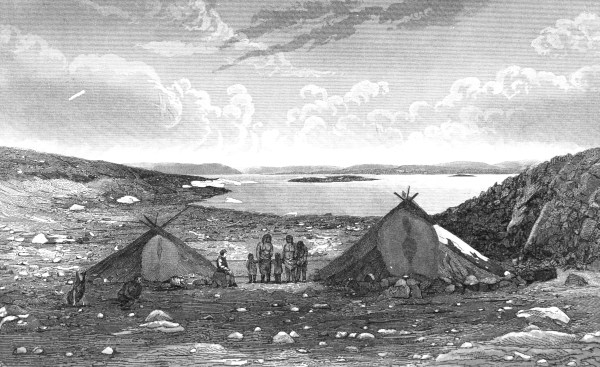
Having failed to enter Ashe’s Inlet on the inward voyage, we crossed the straits to Stupart’s Bay, in Prince of Wales’ Sound. Our visit to this station was too brief to allow me to make any fresh geological explorations in the neighborhood. The geology and scenery of this locality are described in my report of last year. The accompanying engraving, from a photograph, represents a view of the country from Eskimo Inlet, about two miles south of Stupart’s Bay, looking westward, and it may be taken as a characteristic specimen of the scenery on the south side of Hudson’s Straits. I found that Mr. Stupart and his associates had collected numerous geological specimens for me. They consisted of gneiss, soapstone, quartz, felspar, hornblende, mica-rock, epidote and iron pyrites, all apparently derived from ordinary Laurentian rocks, which prevail everywhere in this region.
While at Port de Boucherville, on the south end of Nottingham Island, some further exploration was made in the vicinity, but nothing worthy of remark, was observed.
Niagara formation.
Last year Mansfield Island was found to consist of flat-lying, grey limestones. The fossils then collected, on its eastern side, although badly preserved and not numerous, indicate the age of our Niagara formation.
Southampton Island.
Gneiss.
Similar limestones prevail on Southampton Island (proper) from Cape Southampton to within twenty-five or thirty miles of Cape Pembroke at its north-eastern extremity, the latter interval being occupied, according to Captain William Hawes, of the Hudson’s Bay Company, by rugged, dark-looking rocks, like those of Hudson’s Strait, which are Laurentian gneiss. The large island north of Southampton Island, of which Seahorse Point forms the eastern extremity, and which Lieutenant Gordon has called Bell’s Island, in the absence of any other name, is mountainous and appears to consist of gneiss.
British American Bank Note Co. Montreal
VIEW WESTWARD IN PRINCE OF WALES SOUND, HUDSON’S STRAIT.
SHOWING OUTLINE OF MOUNTAINS IN THIS REGION. ESKIMO TENTS IN FOREGROUND.
Track-survey of Outer Digges.
Glaciation.
In the end of August, while the “Alert” was lying in Port Lapierrière, at Lieut. Gordon’s request, and with the assistance of Mr. James Tyrell, P.L.S., I made a track-survey of the Outer Digges Island. It was found to be about eight miles long and three miles wide, and to be separated from the Inner Digges by a straight channel, about one mile wide. It is formed entirely of Laurentian gneiss, which strikes with the longer axis of the island. This island has been thoroughly glaciated. Around its western end the groovings run north-eastward (true), but along the north side they set more nearly east, showing that the stream of ice was flowing out of the bed of Hudson’s Bay and eastward in the Strait. The outer points of this shore are all rounded and bald, with the glacial grooving and fluting strongly marked, as may be seen in the accompanying sketch of one of these small capes.
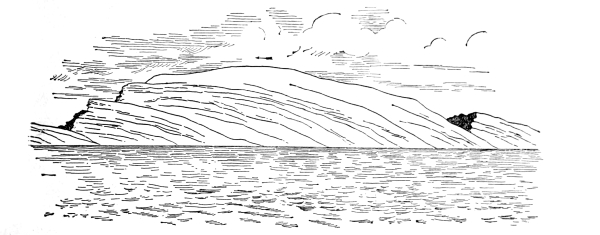
Cape on North Side of Outer Digges Island.
High bluffs of Cape Wolstenholme.
Coast south of Cape Wolstenholme.
Recession of the sea.
Appearance of the country.
The south-eastern part of Inner Digges Island presents a high and nearly vertical cliff, facing the still higher bluffs of Cape Wolstenholme, of which an outline-sketch was given in my report for 1880. From the cape these bluffs continue southward for some miles, diminishing in height and merging into the rounded hills of the coast further down. At about thirty miles south of the cape the country, forming the immediate coast, has become comparatively low, but ranges of partially-rounded hills rise higher and higher towards the interior. On our return from the west side of Hudson’s Bay in the month of September, I explored this part of the coast in a small boat, and found the rocks to consist of common forms of gneiss, with veins and patches of fine-grained red granite in some places. On the mainland, about twenty miles south of Port Lapierrière is a very ancient Eskimo camping ground, which is still inhabited. We could not ascertain from the natives what they called the place, and for the sake of convenience in having some name for it we called it Hyla. In this neighborhood the evidences of the rapid recession of the sea are visible on all sides, in the form of shoaling bays and lagoons, as well as in raised beaches and ridges of shingle. The latter sometimes form the isthmuses, separating bays or connecting islands with each other or with the main land. Ponds and small lakes, of a mile or two in length, are numerous between the ranges of hills, or small mountains in the rear. The clay and sand in the valleys between these ridges, up to an elevation of about 200 feet above the sea, are full of marine shells, of which the genera Tellina, Saxicava, Cardium, Pecten, Mya, Mytilus and Astarte are the most common. Viewed from a distance, these hills and mountains have a naked appearance, but in walking over the country itself, the grasses and sedges, and a variety of Arctic plants which grow around the ponds and lakes, and in sheltered places among the hills, give the landscape a pleasantly green appearance in many places. No shrubs are to be seen except the creeping willows, but the Eskimo make mats for the floors of their summer tents by fastening together, in regular order, twigs of dwarf birch, (Betula glandulosa, Michx.) about three feet long, which we understood they obtained in the interior. The natives on this part of the coast live by hunting the reindeer among the hills, and the white whale, polar bear, walrus and seals on the coast. At certain seasons they also procure a good supply of waterfowl and brook trout.
Large quartz and felspar vein.
Close to the shore, behind an island, and about a mile south of the old Eskimo camps, above referred to, a very conspicuous vein is exposed along the face of a bluff of gneiss. It is about thirty feet wide in one part, and consists of white quartz next the walls, with coarsely crystalline red felspar in the centre. A few plates of darkly-coloured, uneven mica were also observed.
Elevated plateau.
The general outline of the land on this part of the coast, as seen from a distance out at sea to the westward, slopes gradually up to the westward, until the brink of the great precipices of Cape Wolstenholme are reached. The elevated plateau above the precipices has a tolerably even appearance, as if it had been smoothly and uniformly glaciated. The high and almost perpendicular precipices of Cape Wolstenholme and the east end of the Inner Digges Island, which faces each other, present a singular contrast to the planed surface of the Outer Digges, and the apparently glaciated plateau of the mainland above the cape. It is possible that part of the ancient glacier, in passing out of the bed of Hudson’s Bay, became jammed against the inside of the high angular barrier formed by the Digges Islands, on the one hand and the mainland on the other. The narrow channel which separates the Inner Digges from Cape Wolstenholme must be very deep, if we may judge from the quantity of water which flows through it with every tide, producing a strong current in the sea to the south of the Digges Islands.
The Ottawa Islands.
During our short visit to the harbour of Churchill a strong gale of wind with rain prevailed, so that no fresh geological work could be attempted beyond the limits which had been explored in this vicinity in 1879. On the return voyage from Churchill, we visited a large chain of islands in the north-eastern part of Hudson’s Bay, which run north-eastward between latitudes 59° and 60°, terminating in that direction, east of latitude 80°. On some sketch-charts, a group of islands in this part of the bay had been marked “Sleepers,” but as there are also two other groups called North Sleepers and South Sleepers, not far off, Lieutenant Gordon and I named these the Ottawa Islands, in order to distinguish them clearly and to prevent confusion. Lieutenant Gordon made a running survey of the northern part of the chain, and we named the individual islands in honor of the citizens of Ottawa who had generously aided in missionary enterprise in Hudson’s Bay. A copy of Lieutenant Gordon’s chart of the Ottawa Islands accompanies this report. The outermost of these shown on the chart, and called J. Gordon Island, consisted of thick, stratified masses, presenting a variety of external appearances, and probably of volcanic origin, all dipping westward at a moderate angle, as represented in the accompanying outline of the island.
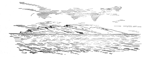
J. Gordon Island from the North.
Greenish-grey diorite.
Copper pyrites and asbestus.
Glacial striæ.
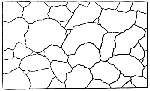
An opportunity was afforded me of landing upon a small island lying about two miles to the south-west of Gilmour Island (see chart) in latitude 59° 48′, longitude 80° 6′. It was found to consist entirely of a greenish-grey diorite, which, on fresh fracture, is mottled with darker and lighter shades. In a vertical section, found on the east side of the island, the diorite presents the “bouldery” or concretionary appearance shown in the annexed sketch, the larger divisions having a diameter of about two feet. The rock is cut by small veins of quartz, running in a northwesterly course (true) in which specks of copper pyrites were detected. It also contains thin, short and irregular veins of asbestus and green epidote. Old weathered surfaces of the diorite are very rough, but nearly the whole island bears the marks of glaciation. On the southern and central parts of the island the principal striæ run N. 60° to 80° E., magnetically, or N. 20° to 40° E., astronomically, the variation of the compass having been found to be about 40° W. Another set of grooves, near the centre of the island, was found to run S. 65° E. mag., or about N. 75° E., true. On the east side of the island the grooves run N. 35° E. mag. or N. 5° W., true.
Northward course of drift.
Belcher Islands.
The forms of the roches moutonné and other evidence afforded by the grooving and fluting of the rocks of this island themselves, go to show that the direction of the glaciating force was from the southward and south-westward and not from the contrary direction. Raised beaches are well marked up to the highest point of the island, about forty or fifty feet above the sea-level. Much of the shingle of the island consists of dolomite of the Manitounuck group, and this fact is a further evidence that the drift in this region came from the southward, since these rocks have, as yet, been found only on the islands and shore of the Eastmain coast between Cape Jones and Cape Dufferin. The islands further out to sea, opposite to this part of the coast are also believed to consist of rocks of the Manitounuck group. Specimens, said to have been broken from the fixed rocks of the Belchers, opposite Little Whale River, were obtained at my request, from the Eskimo and are found to consist of amygdaloid, white and grey dolomite, a soft grey schist and columnar calcspar, the last named apparently from a thin vein.
Appearance of the Ottawa Islands.
All the larger islands of the Ottawa group are bare, rugged and mountainous. The rocks of Perley, Pattee, Gilmour, Booth and Bronson Islands appeared to be all the same as those of the small island which has been described. The surface of the hills, which on Gilmour Island rise to a height estimated to be about 1,800 feet, is everywhere extremely rough and pitted in appearance.
Walruses and white whales.
We found the small island, on which we landed, inhabited by considerable numbers of walruses. Some white porpoises or small white whales (Delphinopterus catodon, Linn.) were also seen in the vicinity. The remains of a number of Eskimo camps and part of the skeleton of a large whale were observed on the island. A few pieces of driftwood had been cast upon it.