CONTENTS
Reading edition
CHAPTER I
GENERAL INTRODUCTORY REMARKS ON SOME OF THE LEADING PHYSICAL
FEATURES OF THE ISLAND
Its remarkable shape, 1.—Its building up, 2.—Study of its profile, 3.—Mount Seatura.—Regions of acid andesites.—Basaltic tablelands.—Great ridge-mountains, 5.—Boundary of the regions of basic and acid rocks, 6.—Its primary features, the dacitic peak, the basaltic plateau, and the ridge-mountain
Pages 1-6
CHAPTER II
ON THE EVIDENCE OF EMERGENCE OR OF UPHEAVAL AT THE SEA-BORDERS
Elevated coral reefs scantily represented, 7.—Apparent absence of coral reefs in the early stages of the emergence, 8.—Elevated reefs confined to the coast and its vicinity.—Detailed examination of the sea-borders, 9.—Silicified corals and siliceous concretions the only evidence in many localities of the upraised reefs, 13.—The relations of the mangrove-belt to the reef-flat, 14.—Indications of a very gradual movement of emergence in our own time, 15.—The rate of advance of the mangroves, 16.—Conclusions, 19
Pages 7-20
CHAPTER III
THE HOT SPRINGS OF VANUA LEVU
The thermal springs of other parts of the group, 21.—The hot springs of the Wainunu valley, 22.—The boiling springs of Savu-savu, 25.—Analyses of the water, 28.—The hot springs of other localities, 31.—Distribution of the springs, 35.—The algæ and siliceous deposits, 37.—The cold and thermal springs of Hawaii and Etna, 38.—Infiltration, the source of the springs, 39.—A view negatived by Prof. Suess.—List of the hot springs of Vanua Levu, 40.—Summary of the chapter, 42
Pages 21-42
CHAPTER IV
DESCRIPTION OF THE GEOLOGICAL AND GENERAL PHYSICAL FEATURES OF
VANUA LEVU
Naivaka, 43.—Korolevu Hill, 45.—Bomb formation of Navingiri, 46.—Remarkable section near Korolevu, 48.—Wailea Bay to Lekutu, 50.—Mount Koroma, 51.—Mount Sesaleka, 53.—The Mbua-Lekutu Divide, 55.—The Mbua and Ndama plains, 55.—The shell-bed of the Mbua river, 58.—Lekumbi Point, 60
Pages 43-60
CHAPTER V
DESCRIPTION OF THE GEOLOGICAL AND GENERAL PHYSICAL FEATURES
(continued)
Mount Seatura, 61.—Its eastern slopes, 63.—Its western slopes, 64.—Its northern slopes, 65.—Ascents to the summit, 66.—The Ndriti Basin, 67.—A huge crateral cavity, 68.—Its dykes of propylite, 69.—Seatura a basaltic mountain of the Hawaiian order, 72.—The Seatovo Range, 73.—Solevu Bay, 75.—Koro-i-rea, 77.—Nandi Bay, 78.—Na Savu Tableland, 79
Pages 61-81
CHAPTER VI
DESCRIPTION OF THE GEOLOGICAL AND GENERAL PHYSICAL FEATURES
(continued)
The basaltic plateau of Wainunu, 82.—Its margins covered by pteropod and foraminiferous ooze-rocks, 86.—The hill of Ulu-i-ndali, 87.—Kumbulau Peninsula, 90.—The basaltic flow of Kiombo Point, 92.—Soni-soni Island, 93.—Yanawai coast, 95
Pages 82-97
CHAPTER VII
DESCRIPTION OF THE GEOLOGICAL AND GENERAL PHYSICAL FEATURES
(continued)
The Ndrandramea district, 98.—Its mountains and hills of acid andesites, 100.—Ngaingai, 101.—Ndrandramea, 102.—Soloa Levu, 103.—The underlying altered acid andesites, 106.—Section of the district, 107.—The magnetic peak of Navuningumu, 108.—The Mbenutha Cliffs and their pteropod and foraminiferous beds, 109
Pages 98-112
CHAPTER VIII
DESCRIPTION OF THE GEOLOGICAL AND GENERAL PHYSICAL FEATURES
(continued)
Mount Vatu Kaisia and district, 113.—The Nandronandranu district, 117.—Nganga-turuturu cliffs, 119.—Ndrawa district, 120.—Tavia ranges, 121.—Na Raro, 123.—Its Ascent, 125.—Na Raro Gap, 127
Pages 113-127
CHAPTER IX
DESCRIPTION OF THE GEOLOGICAL AND GENERAL PHYSICAL FEATURES
(continued)
The basaltic plains of Sarawanga, 129.—Tembe-ni-ndio and its foraminiferal limestones, 131.—The basaltic plains of Ndreketi, 132.—The Nawavi Range, 135.—Nanduri, 136.—Tambia district, 137.—The basaltic plains of Lambasa, 138
Pages 128-139
CHAPTER X
DESCRIPTION OF THE GEOLOGICAL AND GENERAL PHYSICAL FEATURES
(continued)
The Va Lili Range, 140.—Its Nambuni spur, 144.—Originally submerged and covered with palagonite-tuffs and agglomerates, 145.—The Waisali Saddle, 146.—Narengali district, 147.—Nakambuta, 148.—The valleys of the Ndreke-ni-wai, 150.—Their origin, 151
Pages 140-152
CHAPTER XI
DESCRIPTION OF THE GEOLOGICAL AND GENERAL PHYSICAL FEATURES
(continued)
The Korotini Range, 153.—Traverse from Waisali to Sealevu, 154.—Traverse from Mbale-mbale to Vandrani, 156.—Traverse from Vatu-kawa to Vandrani, 160.—Traverse from Nukumbolo to Sueni, 161.—The Sueni valley, 163.—General inference concerning the range, 164
Pages 153-165
CHAPTER XII
DESCRIPTION OF THE GEOLOGICAL AND GENERAL PHYSICAL FEATURES
(continued)
The Koro-mbasanga Range, 166.—The Sokena Ridge, 169.—Lovo valley, 169.—Mount Mbatini, 172.—The Vuinandi Gap, 175.—The Thambeyu or Mount Thurston Ranges, 176.—Structure of Thambeyu, 177.—The Avuka Range, 179
Pages 166-180
CHAPTER XIII
DESCRIPTION OF THE GEOLOGICAL AND GENERAL PHYSICAL FEATURES
(continued)
The Valanga Range, 181.—Its western flank, 183.—Ngone Hill, 183.—Valley of Na Kula, 184.—The Mariko Range, 185.—Savu-savu Peninsula, 189.—Naindi Bay, 192.—The Salt Lake, 194
Pages 181-196
CHAPTER XIV
DESCRIPTION OF THE GEOLOGICAL AND GENERAL PHYSICAL FEATURES
(continued)
The Natewa Peninsula, 197.—Viene district, 198.—Lea district, 199.—Waikawa Mountains, 201.—Ndreke-ni-wai coast, 203.—Waikatakata, 203.—Mount Freeland or the Ngala Range, 204.—Traverse from Tunuloa to Ndevo, 205.—Coast from Ndevo to Mbutha Bay, 205
Pages 197-206
CHAPTER XV
DESCRIPTION OF THE GEOLOGICAL AND GENERAL PHYSICAL FEATURES
(continued)
The north-east portion of the island from Mount Thurston to Undu Point, 207.—Coast between Vuinandi and Tawaki, 208.—The corresponding inland region, 209.—The gabbro of Nawi, 211.—Uthulanga Ridge, 211.—Ascent of Mount Vungalei or Ndrukau, 213.—Nailotha, 214.—Exposure of altered trachytes and quartz-porphyries at its base, 215.—From Nandongo to Vanuavou, 216.—From Ngelemumu to Wainikoro, 217.—Sea border between Lambasa and Mbuthai-sau, 218.—Coast between Mbuthai-sau and the Wainikoro and Langa-langa Rivers, 219.—Coast between the Langa-langa River and Thawaro Bay, 221.—The Globigerina clay of Visongo, 221.—Vui-na-Savu River, 222.—Some General inferences, 223
Pages 207-223
CHAPTER XVI
DESCRIPTION OF THE GEOLOGICAL AND GENERAL PHYSICAL FEATURES
(continued)
The Wainikoro and Kalikoso Plains, 224.—Vaka-lalatha Lake, 225.—Its floating islands, 226.—A region of acid rocks, 227.—Silicified corals and limonite, 228.—Tawaki district, 229.—Thawaro district, 230.—Mount Thuku, 231.—Undu Point, 232.—General characters of the Undu Promontory, 233
Pages 224-234
CHAPTER XVII
THE VOLCANIC ROCKS OF VANUA LEVU
Their varied character, 235.—Their classification, 236.—Descriptive formula, 237.—Synopsis, 239.—Orders of the Olivine-Basalts, 241.—Orders of the Augite-Andesites, 245.—Orders of the Hypersthene-Augite-Andesites, 247.—Description of the Plutonic Rocks, 249
Pages 235-251
CHAPTER XVIII
THE VOLCANIC ROCKS OF VANUA LEVU (continued)
The Olivine Basalts
Pages 252-265
CHAPTER XIX
THE VOLCANIC ROCKS OF VANUA LEVU (continued)
The Augite-Andesites
Pages 266-284
CHAPTER XX
THE VOLCANIC ROCKS OF VANUA LEVU (continued)
The Hypersthene-Augite-Andesites
Pages 285-292
CHAPTER XXI
THE VOLCANIC ROCKS OF VANUA LEVU (continued)
THE ACID ANDESITES, TRACHYTES, QUARTZ-PORPHYRIES.
The Hornblende-Andesites of Fiji, 293.—Occurrence of Dacites in Fiji, 294.—Suggestion of “felsitic andesite” as a rock-name, 295.—The Acid Andesites of Vanua Levu, 295.—The Hypersthene-Andesites, 296.—The Hornblende-Hypersthene-Andesites, 298.—The Quartz-Andesites or Dacites, 302.—Tabular comparison of the Acid Andesites, 304.—The characters of the Rhombic Pyroxene, 306.—Magmatic Paramorphism, 306.—The Oligoclase Trachytes, 308.—Quartz-Porphyries and Rhyolitic rocks, 309
Pages 293-311
CHAPTER XXII
THE VOLCANIC ROCKS OF VANUA LEVU (continued)
Basic pitchstones and basic glasses, 312.—Volcanic Agglomerates, 314
Pages 312-316
CHAPTER XXIII
CALCAREOUS FORMATIONS, VOLCANIC MUDS, PALAGONITE-TUFFS
General Character, 317.—Coral Limestones, 318.—Foraminiferal Limestones, 319.—Pteropod-oozes, 320.—Foraminiferous Volcanic Muds, 321.—Samples, 322.—Altered kinds, 324.—Submarine Palagonite-tuffs of mixed composition, 326.—Samples, 330.—Altered Basic Tuffs, 332.—Submarine Basic Pumice Tuffs, 333.—“Crush-tuffs” formed of basic glass and palagonite, 334.—Zeolitic Palagonite-Tuffs, 334.—Palagonite-marls, 335.—Acid Pumice Tuffs, 336
Pages 317-336
CHAPTER XXIV
PALAGONITE
Its abundance in a fragmental condition in Vanua Levu, 337.—Its occurrence in deep-sea deposits, 338.—Modes of formation in situ, 338.—In the upper portion of a basaltic flow, 339.—In the groundmass of hemi-crystalline basaltic rocks, 339.—In veins in a basic tuff-agglomerate, 340.—In the fissures of a basaltic dyke, 341.—In the matrix of pitch-stone agglomerates, 349.—In “crush-tuffs,” 341.—Regarded as a solidified magma-residuum of low fusibility, 342.—Its connection with crushing, 342.—Bunsen’s experiment, 343.—Rosenbusch and Renard, 344.—The Nandua series of beds, 345.—Suggested explanation of the origin of palagonite, 346.—Type of basalt associated with palagonite, 347.—Hydration and disintegration of palagonite, 348
Pages 337-349
CHAPTER XXV
SILICIFIED CORALS, FLINTS, LIMONITE
Mode of occurrence of the silicified corals, 351.—Their character and structure, 352.—Flints, nodules of Chalcedony, Agates, etc., 353.—Other siliceous concretions, 354.—Jasper, 355.—Deposits of Limonite, 356.—Magnetic Iron-sand, 357.—Suggested explanation of the silicification of the corals, 358.—Note on a silicified Tree-fern, 360
Pages 350-360
CHAPTER XXVI
MAGNETIC ROCKS
Previous observations, 361.—Magnetic Polarity usually caused by atmospheric electricity, 362.—Displayed by both acid and basic rocks, 364.—Very frequent in Vanua Levu, 365.—Its relation to specific weight, 366.—The influence of locality, 367.—Frequently observed in mountain peaks, 367.—Description of the peaks, 368.—Measurement of the polarity of rocks, 370
Pages 361-371
CHAPTER XXVII
SOME CONCLUSIONS AND THEIR BEARINGS
Vanua Levu, a composite island formed during a long period of emergence, 372.—The submarine plateau probably produced by basaltic flows, 373.—The distribution of the volcanic rocks, 374.—Comparison with Iceland, 374.—The mountain-ridges, 375.—The emergence of the Fiji Islands, 376.—Wichmann’s view of the early continental condition not supported, 376.—Age and character of the emergence, 377.—The evidence of the Lau Group and of the Tongan Islands, 378.—Two principal stages of the emergence, 379.—Relative antiquity of the Hawaiian, Fijian, and Tongan Islands as indicated by their floras, 379.—Islands have always been islands, 380.—The hypothesis of a Pacific continent not yet needed, 381.—The great dilemma, 381.—Much remains to be learned of the possibilities of means of dispersal in the past and in the present, 382
Pages 372-382
APPENDIX.
(1) Note on microscopical examination of stone-axes.
(2) Note on the ascent of the tide in the Ndreketi River.
(3) Note on the “talasinga” districts.
INDEX 385
LIST OF ILLUSTRATIONS
Plates
TO FACE PAGE
Na Raro (2,420 feet) from the south-west, a peak of acid andesite Frontispiece
Ndrandramea (1,800 feet) from the south-east, a peak of acid andesite rising about a thousand feet from its base
The Ndrandramea District from the westward 98
Mount Tavia (2,210 feet) from Vatu Kaisia 108
The magnetic peak of Navuningumu (1,931 feet) from the south
Mbenutha Cliffs, showing volcanic agglomerates overlying tuffs and clays, containing shells of pteropods and foraminifera, which are raised 1,100 feet above the sea 111
Duniua Lagoon, representing an old mouth of the Ndreke-ni-wai 153
Lithographs
Vanua Levu, Fiji Islands 1
Fiji Islands 373
Figures
PAGE
Profiles of Vanua Levu as Viewed from the South. Graphically Represented on a Horizontal Scale of about 16 miles to the inch 4
Korolevu Hill (800 feet) from Wailea Bay 46
Profile and Geological Section of the western end of Vanua Levu from the Wainunu estuary across the summit of the basaltic mountain of Seatura to the edge of the submarine platform off the Ndama coast as limited by the 100-fathom line 62
Profile, looking north from off the mouth of the Wainunu River 83
Rough plan of the Ndrandramea district in Vanua Levu; made with prismatic compass and aneroid by H. B. Guppy 99
Profiles of Ngaingai and Wawa Levu from Nambuna to the south-west. Both are dacitic mountains 101
Profile and Geological Section of Vanua Levu, across the island from the Sarawanga (north) coast to the Yanawai (south) coast 107
Profile-sketch of the Vatu Kaisia district from S.S.E. 113
Section of the Vatu Kaisia district 115
Profiles of Na Raro 124
Profile-sketches of the Va-Lili Range 141
Profile-sketch of the mountainous axis of Vanua Levu 167
Koro-mbasanga from the north-north-east 167
Mount Mbatini from the top of Koro-mbasanga 173
View from Muanaira on the south coast of Natewa Bay 173
Ideal Section of Thambeyu 177
Diagram illustrating the two sets of felspar-lathes in a dyke 238
Magma-lakelet, ·25 mm. in size, magnified 290 diameters, from a basalt at Navingiri 339
Showing fragments of glass with eroded borders and of plagioclase with more even edges in a matrix of palagonite traversed by cracks 342
Diagram showing the succession of deposits below the Nandua tea-estate 345
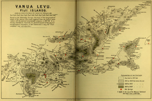
VANUA LEVU, FIJI ISLANDS. Drawn on a scale of 25 miles to 3 inches by H. B. Guppy, M.B. Based on the Admiralty Surveys, but most of the topographical details of the interior have been supplied from the author’s observations with the aneroid and prismatic compass in 1897-99. It is merely intended to illustrate his general account of the physical and geological characters of the island and is very far from complete. (see introduction.)
OBSERVATIONS OF A NATURALIST IN THE PACIFIC