II SOME EARLY HISTORY
Reading edition
In his book, “La Relacion que Dio Alvar Nunez Cabeza De Vaca delo Acaescido unlas Indias”, De Vaca writes in the year 1530 that “we were among the Adayes (Adais), the others were Juan Castillo, Andrea Dorantes and Estabancio of Azmor who was a slave of Dorantes.” These four survivors were of 300 of the Panfilio Narvez expedition that went into Florida in 1528.
Narvez’s expedition, beaten by the Apalache Indians, unable to return to their ships, killed their horses, ate the meat, used the hides to make bellows and water casks; they forged their armor and weapons to make tools and nails, then constructed four boats. They skirted the coasts of Alabama, Mississippi and Louisiana, foraging for food. During a storm the boats were wrecked, four survived to become slaves of the coastal Indians.
De Vaca and his companions became traders and medicine men. Meanwhile they learned to live off the land as the Indians did. They planned and successfully escaped.... And now they were among the Adais seeking directions. They were the first white men to travel westward over the Buffalo Trail. They wandered ever westward and finally found a Spanish patrol from Mexico.
De Vaca was the only one of the three hundred to return to Spain and even before he published his book in 1542, he had inspired the Hernando DeSoto expedition into Florida with his story of the City of Cibola, a city built entirely of gold.
Hernando DeSoto, the Golden Eagle, led the next expedition into Florida. Continuously harassed by the Appalachie tribes of 5 Indians of the southeastern states he crossed the Mississippi and now in the year 1540 he marched into Louisiana, pillaging, raping and destroying. He was assisted by these trusting Lieutenants: Don Luis Moscoso, Don Juan de Anasco, Don Baltazarde Gallegardo, Don Juan Labillo, Don Carlos Chinquez, Juan de Quizman, Don Vasco de Procello, and Don Diago Vasquez, and these Captains: Espilando, Gallegardo, Maldamando, and Luis Fuentes. The Chronnicalor, Gonzado Quadrado Charmillo de Zafra who wrote (From the translations of B. F. French):
“We marched one day west from the Rio de Cannis in all this cold country this Wednesday, March 21, 1541, at the end of the day we came to a place called Toalli. All the Indians have houses built so, the houses are built of reeds in a manner of tules and daubed with mud which show as a mud wall, they are very clean and have a small door; when you shut it up and build a fire within it is as warm as in a stove.”[1]
Don Luis De Moscoso and a scouting party traveled westward over the buffalo trail as far as the Trinity River before returning to the Adais.
For the next hundred and forty years this area was devoid of white explorers.
By early 1682 Cavalier Robert de LaSalle had begun descending the Mississippi River accompanied by Henri De Tonty, the “Iron Hand”, and a party of other Frenchmen.
April 9, 1682, LaSalle discovered the mouth of the Mississippi River and established a plaque there, claiming all land drained by this river for the King of France, Louis XIII. He named this land LOUISIANA in honor of King Louis and Queen Anna.
Returning up the Mississippi near a location in the Illinois country at Starving Rock in that same year he established Fort St. Louis and left Captain Henri De Tonty in command.
6
LaSalle went to France and received assistance so that he could return and establish a settlement at the mouth of the Mississippi River. Through erroneous navigation the expedition missed the mouth of the Mississippi River and traveled westward, landing at Matagorda Bay, and in the Texas country established another Fort St. Louis in 1685.
LaSalle, realizing that this area was not suitable for colonization, began land excursions in an attempt to reach Canada.
Father Joutel’s diary reveals that in January, 1687, he was with LaSalle, and a scouting party, were among the Nakassa Indians which resided on Nakassa Lake.[2]
In 1682 at Quaerataro, Mexico, The College of the Holy Cross was founded by Priests; Father Francois Hidalgo, Father Jose Diaz, Father Felix Isadore Espinosa, Father Nunez, Father Antonio de San Buenaventura Oliverez, Father Francisco Marino, Father Juan Parez, Father DeVaca, Father Salazar, Father Massinettes and Father Margil de Jesus, the last named, Father Margil de Jesus, being chosen as President of the College. These priests, so as to distinguish their work from the work of others called themselves Zatachinies, their purpose being to prepare others for frontier missionary duties. By 1684 they had succeeded in establishing missions south of the Rio Grande.
The most northern Spanish presidio at that time was Fort San Juan Bautista, located on the south bank of the Rio Grande near present day Eagle Pass, Texas. The land of the Coahuile Indians extended from present day San Antonio southward into the Monte Clova-Saltillo area of Mexico. The Matagordo area on the Gulf Coast was included in the land of the Coahuile.
Aside from the duties of the Spanish missions to spread the Catholic faith, they were also, in reality, observation and trading posts of the Spaniards. From one of these missions it was learned from an Indian who came to trade, that other white men had come out of the sea in large houses that floated on the waters of the gulf and had settled on the coast land.
On March 20, 1689, LaSalle was assassinated by some of his own men on a tributary of the Trinity River. Father Joutel 7 reported the men responsible for the assassination were in turn killed by the Indians. The remnants of the party returned to Fort St. Louis and finding it deserted, retraced their journey into the Trinity River area.
Alonzo DeLeon and Captain Flores were leading a scouting patrol when they found Santiago Grislet, Jean Lavaschevque and two very young boys, the Tulon brothers, Roberto and Pedro. This Spanish patrol searched for the next two months for other Frenchmen, but not being successful, returned to Mexico.
1689.
Juan Jarri had, during the absence of LaSalle, deserted Fort St. Louis and had risen to a lordly position among the tribes of the Coahuile Indians. During the search by DeLeon and Flores he had been shifted from tribe to tribe so that the Spanish Patrol failed to capture him. The Spanish now realized that this one Frenchman had the power to upset the semi-peacefulness of the Spanish frontier. The College of the Holy Cross was desiring to extend its Missionary work north of the Rio Grande.
Don Alonzo DeLeon, now the Spanish Governor of the Coahuile Territory, led an expedition to establish three missions among Hasinai Indians south of the Trinity River. He now also found himself in pursuit of a party of Frenchmen (Father Joutel’s party).
Henri De Tonty at the Fort St. Louis near Starving Rock in the Illinois country, realized something was amiss and came in search of LaSalle. It is interesting to note how De Tonty, in all this vast country of the southern United States area chose the exact direction in which to travel. Probably the Caddo federation of Indians had trade agreements with the Indian tribes as far north as the Illinois and even further north among the Ouisconsins, to the west they traded with the Hasinais who in turn traded with the Coahuile Indians.
The Amole root (a species of the Yucca plant) was supplied to the Hasinais by the Coahuile Indians. The Caddos traded for this root, which had cleansing properties such as soap and when boiled in water this liquid was used for bathing purposes, it left a pleasant odor on the body of the user.
8
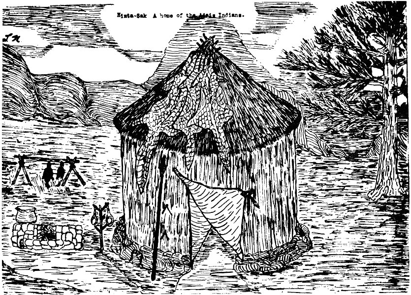
Hinta-Sak: A home of the Adais Indians.
This drawing of a Caddo hinta-sak, or house, was made from the description of an eye-witness, Gonzado Quadrado Charmillo, one of the chroniclers of the De Soto expedition which visited the El Camino Real area in 1540.
This Indian home was that of the Adais tribe near Robeline, La. of the Caddo Federation. It was made of cypress poles and cane interlaced with vines and daubed with a mixture of mud and moss. The roof was covered with alligator skins which had been treated with bees-wax to make it more impervious to rain. The broad leaves of the cat-tail plant were inserted in the mud to prevent erosion from rain. Thus the Spanish called the place toaille, a deprecatory description of a house built of tules. (Drawing by the author)
9
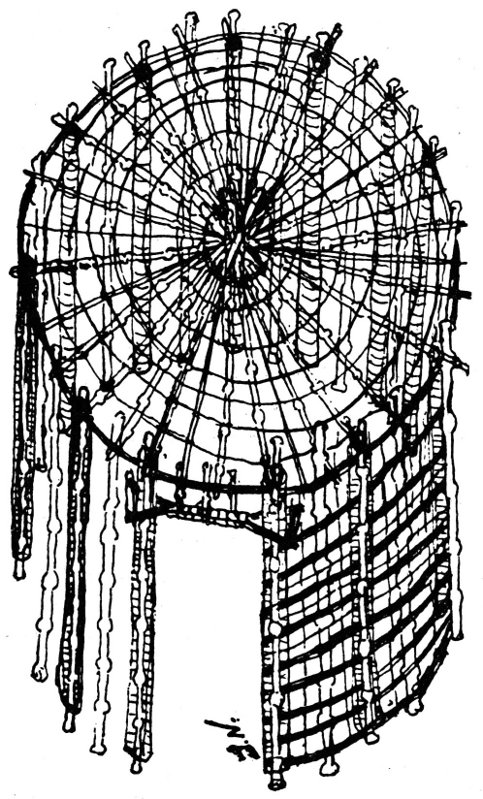
Top view of hinta-sak showing frame work and construction (Drawn by the author)
10
The Jumas, traders of the Caddo Indians, were also linguists and it would not have been impossible for them to distinguish the difference of the French and Spanish languages. The same Jumas of the Caddos traveled all of the Caddo trails. The Old Buffalo Trail extending from the Trinity River in Texas to the Red River in Louisiana was now considered part of the Caddo trail system.
In 1690 in the early spring De Tonty, “The Iron Hand,” was among the Adais Indians and the Natchitoches Indians. He, too, went as far as the Trinity River in Texas, but there his guides refused to go further; he gave up his search for LaSalle. In the same year the Joutel Party found the Buffalo Trail beginning at the Trinity River. There among the Hasinai they learned of the Frenchman with the iron hand. They followed the Caddo trail and finally came in contact with De Tonty among the Arkansas Indians. Strangely enough, De Tonty actually came within one days march of finding the Joutel Party.
1690-1691
From the missions south to the Trinity River came the report of two French patrols in the vicinity of the Hainais which also coincided with the report of Don Alonzo De Leon.
Late in 1690 the Don Domingo Teran Del Rios’ expedition left Mexico, and scouted the complete area of the Caddo and Hasinai Federations of Indians; Teran listed the four tribes of the Hasinai as Bidia, Nabadache, Nadaco and the Nacogdoches. Of the Caddos were the Ais, the Adais, the Natchitoches, the Koasatas; he missed the Pedicaddo but listed the Caddoquopois near present day Fulton, Arkansas. He was the first white leader to sight Lake Bistineau. It is believed that the location Father Massinetes, who was with this expedition, established was La Mission Loretteto, near present day Ringgold, Louisiana.
For the reason Teran had not contacted any Frenchmen in all the territory and much to the disappointment of the members 11 of the College of the Holy Cross, all missions north of the Rio Grande were withdrawn.
Padre Francois Hidalgo, being determined to establish missions north of the Rio Grande and among the Texas Indians, which were called by the Spaniards the Federation of Hasinai Indians, secured the support of the College of the Holy Cross to appeal to the Viceroy of Mexico. They only succeeded in obtaining permission to establish a mission at their own expense south of the Rio Grande but in an area visited by the Hasinai Indian traders. On November 7, 1698 Father Francois Hidalgo, assisted by Father Salazar, established the mission Maria de Los Delores, ten leagues north of Lampassas and ten leagues west of the Rio Sabinas. (Note: this Sabine River is not to be confused with the Sabine River which is the boundary between Louisiana and Texas).
From this outpost mission Francois Hidalgo conceived the idea of a “Chain of Missions” to extend to the very eastern edge of the Texas Indians’ territory. He had at his disposal the reports of Father Massinetes and those of Teran and DeLeon. He knew that the land with its fertile soil and the enormous growth of forests, together with an abundance of wild game of the forests and fish of the lakes would supply many families of the frontier settlers with food and shelter. These families, who at this time were no better off than when they left Spain to settle in Mexico, would welcome such an opportunity.
1700
From the Journal of Father Paul De Ru. February 1, to May 8, 1700.
“Iberville, having founded the Fort at Biloxi, ascended the Mississippi River. At the village of the Tensas Iberville became ill but sent westward St. Denis and Bienville with nineteen other Frenchmen, two of whom were the Tulon brothers, Roberto and Piedro;[3] at the village of the Tensas was a Wichita Indian whose 12 tribe had settled near the Tensas.” This Indian declared he had visited a Spanish mission in the Texas Country (The mission Maria de Los Delores). The Indian was immediately employed by Bienville as a guide.
On April 20, 1700 the St. Denis-Bienville party reached the Yatasee village on Nantanchie Lake near present day Montgomery, Louisiana (See Location 5 on map).
The Frenchmen were among the Natchitoches Indians (Location 8 on map), on May 8, 1700 for on this day Bienville departed with Father Paul De Ru leaving St. Denis to scout the locations of the Caddo Indians. Bienville, having secured pirogues from the Natchitoches Indians, returned by water down the Red River to the Mississippi and back to Biloxi. St. Denis soon followed and brought with him a number of the Natchitoches Tribe of Indians, who settled on the north shore of Lake Pontchartrain. St. Denis settled near by at Fort Louis.
1701-1707
During these years Father Hidalgo and Father Salazar were trading and preaching to the Indians at Mission Maria de Los Delores. Father Hidalgo traded with the Indians for gold; Anya, who was then the Governor of Coahuile, was aware of this. There are several historical records referring to the raiding of the Hidalgo mission in search of gold. Hidalgo at first did turn the gold over to the government, part of which was to be given to the College of the Holy Cross. A Captain Hernandez was broken in rank when he gave Hidalgo a receipt for the gold. Padre Hidalgo realized that very little, if any, of the gold was reaching the King of Spain.
Anya conceived the idea of cutting off the supplies of trade goods to the mission so that the Indians would then have to come and trade at the Presidio San Juan Bautista. Captain Hernandez upon the urgence of the Priests of the College was restored to rank. Father Hidalgo, realizing that no one would actually know how much gold he was accumulating, began to hoard the gold.
13
Allarge Bejoux, operating from a location near present day Pointe Coupee, had cut a road or trail overland northwestward to intersect the Buffalo Trail west of the present town of Many, Louisiana, and had by the year 1708 established trade agreements for horses with the Ais Indians (See Location 10 on map). Francois Hidalgo through his trade with the Indians of different tribes soon learned of this.
A Legend of the Flores Family
Hidalgo and Salazar with assistance had solicited the aid of the Flores families of Saltillo, some of whom were merchants and others owners of landed estates. The merchants supplied the mission de Los Delores with trade supplies.
Through Bernardino, Sub-chief of the Hasinai Indians, Hidalgo learned of a meeting place called Campti, where each Fall of every year all of the tribes of the Caddo Federation of Indians gathered for sports and trading purposes. (Campti was the name of the Chief of the Natchitoches tribe who had organized this meeting, held on a great sand-bar near present-day Campti, Louisiana). These meetings were of a secret nature and not sanctioned by the Spanish Government, and the tradition of their occurrence had remained with the Flores family. Hidalgo prevailed on the Flores family, who knew the value of land and what it could produce for settlers, to assist him by sending men to go on a trading expedition to the Campti. Bernardino was to act as guide.
Ramone Flores and a cousin, Joseph Colliea, were designated by the elder Flores to go and assist the Spanish priests. These two made four trips in the Fall of the years 1708, 1709, 1710 and 1711 to the Sand-bar near Campti, Louisiana.
The Letter
Francois Hidalgo committed an action which might well be considered treason by the Spanish Government. He wrote three letters of the same content, all dated January 17, 1711, addressed 14 to the Governor of Louisiana. Only one reached its destination. In mid-summer of 1713 the Governor of Louisiana, La Mothe de Cadillac, had the letter in his possession. (There is always an incident in history which incites a chain reaction in such a way that a new era begins, always resulting in the establishment of new frontiers. The Hidalgo letter was such an incident).
One must surmise how such a letter could travel through nearly a thousand miles of wilderness and reach its destination. The whole new frontier of El Camino Real hinged on this accomplishment.
The contents of the letter showed that Father Hidalgo had first-hand knowledge of the land of the Hasinai and the Caddos as well as the waterways of the adjoining area. He wrote that the French traders were to ascend the Mississippi to the confluence of the Red River, then ascend the Red River to the tribe of the Natchitoches Indians, thence to travel westward over the Buffalo Trail to the Hasinai Indians and there procure guides to the Hidalgo Mission.
Father Hidalgo could have acquired knowledge of the Caddo area from the reports of De Leon, Teran and Father Massinetes, but he would have not had the knowledge of the waterways, which could have only been obtained from the Natchitoches Indians who may have come to the Campti from their location on the north shore of Lake Pontchartrain; information was given to Flores and Colliea and passed on to Hidalgo.
The letter was an invitation “to come and trade” with the Hidalgo mission, the word “trade” being used as bait could have come from two sources, that of Bejoux to the Ais and that of Flores and Colliea. It is possible that Hidalgo wrote the letters very early in the year so that one could be sent to the Ais Tribe ahead of the arrival of Allarge Bejoux. The later two letters were carried in the Fall of the year by Flores and Colliea, who in turn gave the letters directly to a Natchitoches Indian who had come to the Campti, but who was living on the north shore of Lake Pontchartrain. Several historians say that St. Denis had the letter in his possession before it was presented to Governor Cadillac. St. Denis through his association with the Natchitoches 15 Indians, who were settled near his Fort Louis, would have been the most logical Frenchman to receive the letter. Then, too, St. Denis, while vying with Cadillac to be sent as the leader on the trading expedition to the Hidalgo mission, had stated that he and Jules Lambert, who was at that time in the Illinois country, had been on a trading trip to the Natchitoches Indians in the summers of 1710 and 1712. Here, then, is another possibility that St. Denis may have received the first letter sent by Francois Hidalgo by an Indian messenger to the Ais, and who was instructed to give the letter to the first Frenchman who came to trade in his area.
The letter had the desired effect; St. Denis was appointed to lead the expedition. Cadillac chose wisely because St. Denis was an educated man, and was a third generation Canadian and, further, he understood the ways of the Indians. He was a linguist and could speak many Indian dialects, and also speak, read and write in Spanish.
The trading expedition, consisting of Indians of the Natchitoches tribe, left Biloxi in mid October, 1713. Among the Indians were the White Chief, his son, Koanan, and two daughters, one called Quilchil, “the pretty weaver,” and the other called Olchogonime, “the good girl.”
The Jean Penicaut narrative is an actual eye witness account of St. Denis’ journey to Natchitoches and on to Mexico. The party consisted of nearly forty Indians and twenty-three Frenchmen, two of whom were St. Denis and Penicaut, and several French traders, Pierre Largen, Jean Lagross, Roberto Talon, Pedro Talon, Lafrinaries, Allarge Bejoux, Labinaries, Enrique Lantillac; Medar Jalot, who was valet and doctor to St. Denis; the two Barberousse brothers were hunters for the party’s food; Rambin was a tailor. Soldiers in the party included Lt. Phillippe Blondell, De Lery, De Muy, Williard Anvillaries, De Beaulieux, De Voixant, Frainbouis, and Lavasseur, who was also a map maker.
Leaving Biloxi, the party traveled what was then known as the Iberville passage, crossing Lake Pontchartrain and through Manchac Pass to Lake Maurepas, then into Manchac Bayou and 16 a short portage to the Mississippi River; ascending the Mississippi to the confluence of the Red River at Baton Rouge, then ascending the Red River to a point opposite the present day town of Colfax. Here the stream divided and Penicaut wrote, “we took the left and larger branch of water.” After some distance upstream he describes the Ecore de La Croix, which must have been the high bluffs near Chopin, Louisiana.
On November 25, 1713, the St. Denis party arrived among the Natchitoches Indians, living on an island that the river formed by dividing into two branches and flowing around it.
St. Denis spent the first few weeks cultivating the friendship of the Indians. Trade was vigorous and profitable, he sent at least twice back to Biloxi for more trade goods. He had traveled at least once as far as the settlement of the Nacogdoches Indians before deciding on an exact location for a trading post. In early Spring of the following year two block houses were erected in the Natchitoches Village, one to store the merchandise and the other to house the ten Frenchmen who were to remain in Natchitoches while the others went west in search of the Hidalgo mission.
While St. Denis was among the Hasinai Indians, an incident happened which causes one to wonder at the foresightedness of Francois Hidalgo. Among the Indians was an Indian maid named Angelica who had received instructions at a Spanish mission and who spoke Spanish fluently. She became the interpreter between St. Denis and Bernardino, Chief of the Hasinai. Bernardino, with some of the members of his tribe, acted as guide, for St. Denis, but instead of bringing the Frenchmen to the Hidalgo mission, they were led to Presidio San Juan Bautista on the south bank of the Rio Grande River on July 19, 1714. Surely these Indians would have known where the Hidalgo mission was located; the leading of the Frenchmen to the Spanish post was just as Hidalgo would have wished, or planned.
17
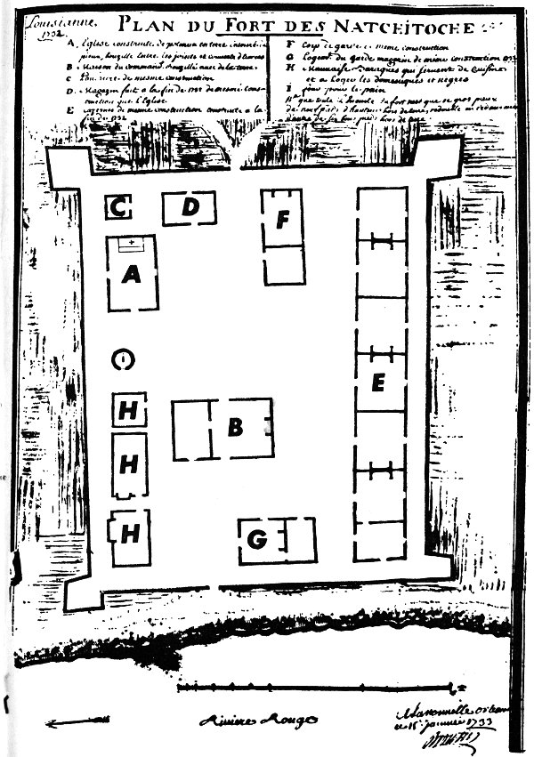
PLAN OF FORT NATCHITOCHES
Plan du Fort des Natchitoche.
A. Church.
B. Home of the Commandante.
C. Gunpowder and arm storage.
D. House of the priest, and where records were kept.
E. Barracks of the militia.
F. Guardhouse.
G. Dining hall for soldiers.
H. Houses of domestic servants and kitchen.
I. Privy.
18
There was quite an uproar at Post Du Nord, as the French called the Presidio San Juan Bautista. The French trade-goods were confiscated, and St. Denis was confined to the area inside the presidio. Somehow St. Denis found out about the plans of the Spanish priests to establish missions to the east, and sent word back to Bienville. The Frenchman knew that very often presidios followed the establishments of missions. Bienville was informed by St. Denis that this land belonged to the French.
Claud De Tisne was dispatched to Natchitoches to build a Fort in 1716, Post St. Jean Baptista Des Natchitoches, naming the post after the title given by St. Denis when the two block houses were built in the spring of 1714.
St. Denis remained in the custody of the Spanish from 1714 until February 17, 1716, when he arrived at Presidio San Juan Bautista. When the Don Domingo Ramone expedition left Saltillo, Mexico, St. Denis was selected as guide, along with several other Frenchmen, Medar Jalot, the two Talon brothers, Pierre Largen and Jean Lagross. The other Frenchmen who were with St. Denis had previously returned to Natchitoches, undoubtedly carrying messages for St. Denis. Medar Jalot declared later that he had delivered messages four times for St. Denis, thus the French had been kept well informed of the goings-on of the Spanish.
St. Denis while on this adventure married a Spanish wife, Manuella Sanchez Ramone, daughter of the Alverez, Don Diego Ramone at the Spanish Presidio. He left her at the presidio, which was also her home, and returned to Natchitoches.
The Ramone expedition established the following Missions:
San Francisco de Los Delores on the Neches River, La Purisima Conception on the Angelina River, Mission San Jose, North of Nacogdoches, and Mission Neustra Senora de Guadelupe at Nacogdoches.
All of these were established in 1716.
19
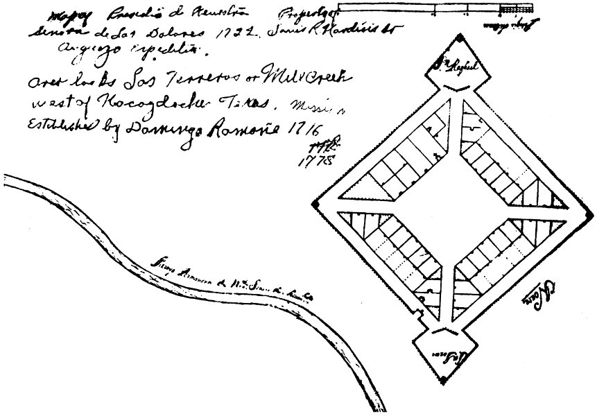
LA PRESIDIO NUESTRA SENORA DE LOS DELORES
La Presidio Nuestra Senora de Los Delores was erected by Domingo Ramone in the summer of 1716. It was later repaired by the Marquis De Aguayo in 1722. The plan of the fort is the work of Aguayo. The fort overlooked Los Torres, or Mill Creek, near the intersection of the lower Douglas Road and the road from Douglas to Wells just west of Nacogdoches, Texas. This presidio was erected and garrisoned to protect the three Missions in the near Nacogdoches vicinity.
La Presidio Nuestra Senora de Los Delores was abandoned in 1731. (Drawing by the author).
20
In 1717 father Margil de Jesus and Father Francois Hidalgo established two missions further to the east, La Mission Nuestra de Los Delores among the Ais Indians, near the present day city of San Augustine, Texas, and on the first day of St. Michael the Archangel, September 29, 1717 established La Mission de San Miguel Cuellar de Los Adais, among the Adais Indians, one mile north of present Robeline, Louisiana.
At this moment Father Francois Hidalgo’s vision had come into being—after twenty-five years of dreaming, he had established his chain of missions to the very end of the Texas Country.
With the establishment of this last mission among the Adais Indians just fifteen miles away from the French post at Natchitoches, both the French and Spanish realized that each must maintain settlements so as to hold the territories thus far gained.
War broke out between France and Spain in 1719 and in that same year Phillipe Blondell from the French post among the Natchitoches Indians, raided the mission among the Adais and allowed one prisoner to escape after making known to him that the French were coming in multitudes to drive the Spanish back. This caused a withdrawal of all Spanish Missions in the Texas area as far as San Antonio.
Every country has its “man of the minute”, and this country of New Spain was no exception. He offered his wealth and abilities to restore the Texas missions and to re-occupy the Texas country. The new governor of Coahuile and the Texas region was the Marquis de San Miguel de Aguayo, his title was Don Joseph de Alzar, Knight Commandante de Aragon, Governor and Captain General of the Provinces of Texas-New Phillippines and of Coahuile, New Kingdom of Estrandura—and he had earned every one.
21
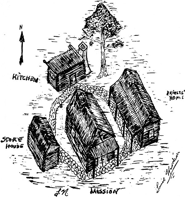
LA MISSION DE SAN MIGUEL DE CUELLAR DE LOS ADAIS
The Mission de San Miguel de Cuellar de Los Adais was founded by Padre Margil de Jesus and Padre Francois Hidalgo on September 29, 1717. September 29 was also the Feast Day of St. Michael the Arch Angel and the Mission was named for him.
The site of this Mission is one-half mile northwest of Robeline, Louisiana, on a hill which overlooks a small valley, and across the valley one-half mile north of another hill was the Presidio de Nuestra Senora del Pilar de Los Adais.
Fra Jose de Solice visited the Adais area in 1767 and kept a Diary of his visitation in which he noted that the Mission Records showed: 256 Baptisms, 64 Marriages and 116 Burials.
In this Diary were listed the names of families he visited in the Adais area: Bano, Cachon, Flores, Bustamenta, Garcia, Solice, Martinez, Sanchez, Rodriguez, Sanchon, Mora, Benetis, Cartinez, Carlos, Vega and La Lima, y Barbo, Cazorla, Fuente, Gallerado and Gonzalez. Cardova, Duro, Mancheca, Solice, Mercado, Guerra, and Bautimino.
KITCHEN
PRIESTS’ HOME
STORE HOUSE
MISSION
22
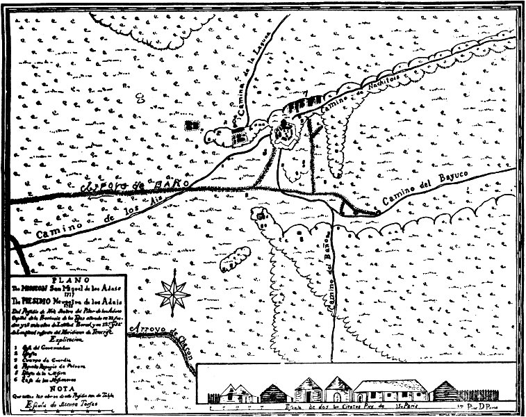
Explanation of map of: La Mission San Miguel de Cuellar de Los Adais and Mission established September 29, 1717; Del Presidio de Neustra Senora del Pilar de Los Adais, presidio established November 1721.
PLAN. This presidio shown on this map of 1722 was the Capitol of the Providence of Texas and is located at 32 degrees and 15 minutes latitude and 285 degrees and 52 minutes longitude. The scale, Toise, one Toise equals six feet. The present day location is one mile north of Robeline, Louisiana, just one quarter mile west of Highway Six from that point.
Camino del Bayuco, road to Bayuco. (Bayuco, a house of Entertainment—A Night Club of that period.)
Camino de los Ais, road to the Ais tribe of Indians at San Augustine, Texas. This was the dry weather trail and passed through Marthaville, Belmont, Zwolle and Ebarb, Louisiana.
Camino de la Laguna, road to swampy lake area, Spanish Lake.
Camino del Bano, road to Rancho Bano, allotted to the Mission, also a part of El Camino Real.
Arroyo de Chacon, small river of Chacon, named after Chacon who had settled on the Creek—Winn Break today. (Chacon is also a Spanish dance which had its own music set to special tempo.)
23
By the middle of October, 1720, the Aguayo expedition was well on its way to the Los Adais area, with three thousand nine hundred fifty horses and six hundred mules, loaded with powder, shot, food, clothing and six cannons, five hundred eighty-four men AND two hundred thousand piastres to build presidios on the frontier.
Aguayo, while en-route to Los Adais, received word the war between France and Spain had ended and there would be no war on the frontier, never the less, Aguayo established the missions and the Presidio San Antonio de Bexar at San Antonio. At the tribe of the Adais he began proceedings to establish a presidio there. France, too, had their “man of the minute” in the person of St. Denis.
24
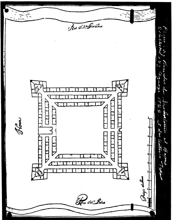
LA PRESIDIO DE SAN ANTONIO DE BEXAR
La Presidio de San Antonio de Bexar, established by Aguayo in 1722, was located at San Antonio, Texas.
The work of Aguayo in establishing the presidios along El Camino Real gave permanence and protection to the Spanish settlers who were to follow, from San Antonio to the Adais in Louisiana, seeking a new kind of freedom. Their source of food and other essentials was so far away that they learned to live “off the land”, and became dependent on no one. As far as they were concerned the head of the Spanish Government was so far away he was only a figure of speech to them. This freedom was bred into their descendants—the seed cast by Francois Hidalgo, fortified by Aguayo, nourished by El Camino Real and the Neutral Strip was to blossom into the State of Texas at San Antonio.
26
PLAN OF FT. DEL PILAR DE LOS ADAIS
1. House of the Governor.
2. Church, which was enclosed within the Presidio.
3. Houses of the Soldiers stationed there.
4. Powder Magazine.
5. La Mission San Miguel de Cuellar de Los Adais.
6. Priests’ home.
7. Dwellings of the Adais Tribe of Indians.
8. The Rancho of La Lima, possibly the first merchant and Indian trader of the Spanish in this area.
27
With St. Denis came the balance of power, which is necessary on any frontier. The Spanish had the French out-numbered ten to one, but they also knew that the tribes of the Caddo Federation favored St. Denis and the French. The gold piasters were of special attraction, as they would have been in any locality, to St. Denis, who was an accomplished trader. Aguayo was quick to realize that the Spanish must trade with the French for food and their very existence. He turned a deaf ear to Captain Reynaud, St. Denis and Bienville, who was now the Governor of Louisiana, and their protests concerning the building of a presidio at Los Adais, and on October 12, 1721 celebrated the rebuilding of the mission. On November 1st in the same year was celebrated the re-establishment of La Presidio de Nuestra Senora del Pilar de Los Adais—the Presidio housing the Governor of all the province of Texas.
In 1722 St. Denis was made Post Commandante of Fort St. Jean Baptiste des Natchitoches and all of the Red River Territory.
Breutin’s map of 1722 of the Natchitoches area, shows the names of inhabitants who owned land: Durion, Derbonne, Duplisses, Marachal, Lebrun, Boquet, Prudhomme, LaFleur, Roland, St. Denis, Dauphine, Rondain, Frainbouis, Rambin, Robert and Frainaries.
Other known inhabitants of the Natchitoches area were: Redot, Lieutenant of the Company of the West; Marley Dupuy, Ensigne; Medar Jalot, St. Denis’ valet; Pierre Cotolleau, farmer; Pierre Fausse, Farmer; Francois Berry, soldier; Francois Lemoine, soldier; Estinne LeRoy, soldier; Pierre DuBois, blacksmith; Marainne Benoist, housewife; Louise Francois Gillot, housewife; Pierre Dupuy, called Gaupillion, to distinguish him from Dupuy the ensigne; Jeanne Grinot, housewife; Collette de Poissot, housewife; Marie Cathern de Poutree, housewife; Martine Bonnet, housewife; Antoniette Audebrands, housewife; Pierre Marineau; Sieur De Champingnole, sergeant; Lieutenant Maillard; Louis Reclos, soldier; Emanuella Sanchez Ramone, wife of St. Denis; Sieur Barme, storekeeper; and Jean Lagross and the two Barberousse brothers who had settled near Campti, establishing a trading post among the Yatasee Indians, which had moved from Nantanchie Lake in 1722.
28
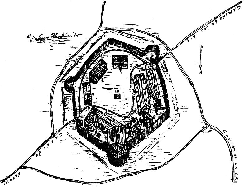
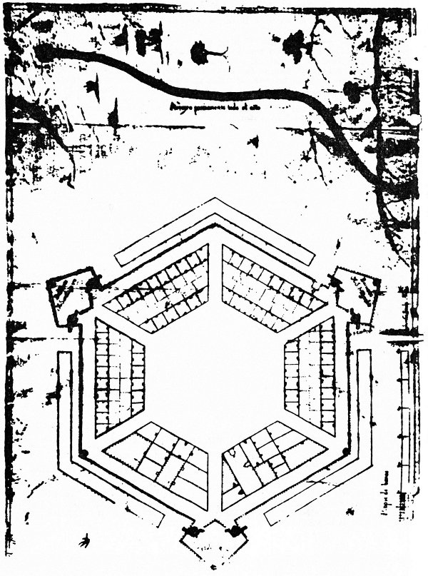
LA PRESIDIO NUESTRA DE SENORA DEL PILAR DE LOS ADAIS
Established in November 1721 and completed early in the Spring of 1722 by the Marquis de Aguayo.
Knights in Armour are usually associated with the European countries and the valiant deeds accomplished by such men, but here on this tiny hill among the Adais Indians two Knights met, The Marquis de Aguayo, a Black Knight of the Argonne, and Louis Juchereau de St. Denis, who had previously received The Order of the Cross of St. Louis delivered to St. Denis by D’Artagnan, a direct envoy of the King and Queen of France. Thus, two Knights met at the Adais, supped and visited, each recognized the abilities of the other, each having received the highest honor which could be bestowed by their respective King.
Camino de Los Ais
Camino de la Lag
Camino de Natchi
1. Governor’s House.
2. Church.
3. Soldier’s Barracks.
4. Guardhouse.
5. Stables.
6. Mess Hall.
7. Kitchen.
8. Privy.
9. Powder Magazine.
10 and 11. Water wells.
29
This Spanish Fort was erected in the shape of a hexagon. Aguayo had six cannons and building the Fort in this shape permitted the greatest amount of cannon fire in all directions. One will notice that on the hilltop, the site of this Spanish presidio, several hundred yards in all directions there is an absence of large trees and that those that are growing are second and third-growth trees. The reason is that Aguayo followed the same methods a trained military officer would have done. He would have cleared the Land of all trees and undergrowth for at least three hundred yards in all directions, so that should an attack occur, the enemy would not have the benefit of any kind of natural cover. The shoulder guns of that period had a fairly accurate killing effect for a distance of 150 yards. Therefore the Musketeer in the presidio would have some extra 150 yards in which to sight the enemy, take aim and fire. This presidio is unique in this respect: It stood for nearly fifty years as a frontier command-post and never once had to defend itself.
This plan of the Presidio at Los Adais, showing the effectiveness of a hexagon shaped fort with cannon spaced to give the maximum protection to the fort, was submitted to Aguayo to his superiors at Mexico City in 1722.
The Presidio Nuestra Senora del Pilar de Los Adais has a very unique history, it stood guarding a frontier against another nation and among the Indians, who were at that time, considered savages, for nearly fifty years, yet this fort never had to defend itself against any hostile demonstration.
30
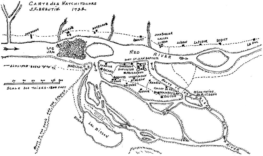
Carte des Natchitoches J.F. BREUTIN. 1722.
31
Pierre Largen was trading among the Peticaddos and the Caddoquopois.
La Petit was among the Peticaddos on Caddo Lake near Shreveport, he had the year previously established a trading post there.
Jean Lagross, who had also married an Ais maiden, had a trading post among the Ais Indians on the Angelena River near the present town of San Augustine, Texas. He was not molested by the Spanish because of the marriage he was considered a member of the Caddos of which the Ais was a tribe.
In 1723 St. Denis sent Lieutenant Antoine Layassard to establish Post Du Rapides near present Alexandria. The year previously LaPerrier and his two daughters had been assassinated at the rapids portage by a band of roving Indians, and Post Du Rapides was established to protect travelers en-route to Post des Natchitoches.
In this same year, 1723 St. Denis received reinforcements, Doctor Alexander, Lt. Basset, Lt. Renault de Hautrive and Paul Muller. Michael Robin, a Notary for the Company of the West was also in the group.
Augayo, tiring of the frontier, left for the interior of Mexico. He appointed as Lieutenant Governor of Los Adais, Lieutenant of the King, Almazon, who immediately set up a new trade restriction, forbidding fraternalization and trading of any sort with the French. It was during the tenure of Almazon that a land grant was issued to Juan Sanchez comprising one square league of land (the grant was an area now consisting of high ground astraddle Toplecot Creek in the Allen area between Robeline and Powhattan, Louisiana). Almazon allotted land to Cadet Chacon. There was also land allotted for the support of the Adais mission called Rancho Bano. Manuel Guiterez, who had wed Maria Garcia, also received an allotted land grant. The last three allotments of land were in the immediate Robeline township area.
St. Denis could see permanence in this establishment of farms in the Adais area. The presidio there now had a fighting force 32 of one hundred men-at-arms, many of which were well-mounted and excellent cavalry men. He could to a certain extent visualize a self supporting Spanish frontier if the farmers’ production of crops were successful. The Spanish would need only slight assistance from the Indian farmers with the sale of their produce to the Spanish.
St. Denis retaliated by inviting all of the chiefs of the Caddo tribes of Indians to come to the Post St. Jean Baptiste to receive presents, knowing that all of the chiefs would bring their families and a number of followers and that many would have to pass the Spanish presidios on their way to Natchitoches. He was successful in working out a trade agreement with all of the tribes to buy their entire surplus food supply.
This alliance of the Caddo federation with the French restored the balance of power on the Spanish-French frontier. St. Denis assured the Caddo chiefs that each year such presents would be available as long as the alliance was kept.
This one move by St. Denis brought safety to the French of the area. Thus any unpleasantness which arose thereafter was confined to verbal statements or letter writing.
33