Volume 1 — APPENDIX.
Reading edition
———
TABLES of LATITUDE and LONGITUDE, VARIATION of the COMPASS, TIDE, and HEIGHT.
MAGNETIC OBSERVATIONS, discussed by Major Sabine, R.A., F.R.S.
ZOOLOGY; including Mammalia—Birds—and Shells.
COPIES of ORDERS.
EXTRACTS from a Paper published in the Journal of the Royal Geographical Society.
EXTRACT from a Game-book.
INDEX.
TABLES
OF
LATITUDE AND LONGITUDE, VARIATION OF THE COMPASS, AND TIDE.
———
I.
COASTS OF BRAZIL, RIVER PLATA, AND EASTERN PATAGONIA.
———
The Latitudes to which the character is prefixed, have resulted from Astronomical Observation. The Longitudes which have been determined by Chronometers, are designated by C.; and those by Lunar Distances by . Those without distinguishing marks are the result of Triangulation.

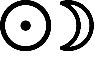
The Longitudes in the following Tables depend upon that of Villegagnon Island at Rio de Janeiro, which was found by fourteen Chronometers from Plymouth to be 43° 05′ 03″ West of Greenwich.
Coast, &c. Name of Latitude South. Longitude West. Variat East. Tide.
Place. Particular Spot. H. W. at F. & C. Direction of Flood, and Rise of Tide.
° ′ ″ ° ′ ″ ° ′ H. M.
Coast of Brazil. Santos Arsenal 23 55 51 C. 46 16 33 4 22
—— Moela Lighthouse 24 03 06 C. 46 12 20
Alcatrasse Island Centre 24 08 10 C. 45 39 15
Abrigo Island Centre 25 07 28 C. 47 52 51
Figuera Island Centre 25 21 29 C. 47 54 11
Paranagua Fort on the Bar 25 30 14 C. 48 17 10 5 44
—— West Point of Cotinga 25 29 50 C. 48 26 32 5 34
—— Church of Sta Antonina 25 25 42 C. 48 39 52
St. Catherine Sta Cruz d'Anhatomirim 27 25 35 C. 48 29 41 6 30
—— City, President's House 27 35 30
Cape St. Mary Extremity 34 40 20 C. 54 05 58
River Plata. Gorriti Island Well at N.E. end 34 57 00 C. 54 53 38 54 53 40 13 48
Monte Video Rat Island, Flagstaff 34 53 23 56 09 30 11 23
—— Cathedral, Cupola 34 54 37 56 07 35 12 07
—— Lighthouse on Mount 34 53 21 56 11 04
Buenos Ayres Cathedral 34 35 50 C. 58 17 53
East Coast of Patagonia. Port Sta Elena Observy marked on Plan 44 30 45 C. 65 17 25 19 10 4 0 17 feet
Cape Two Bays Hill at projecting Point 44 58 00
Cape Blanco North Point 47 15 00
Port Desire Ruins 47 45 05 C. 65 51 45 19 42 12 10 18½ feet
Penguin Island Mount at North end 47 54 45 65 41 30
Sea Bear Bay Sandy Beach at S. side 47 56 49 C. 65 44 00 20 47 12 45 20 feet
Shag Rock Rock 48 08 25 65 52 56
Watchman Cape Monte Video 48 18 55 66 18 00
Bellaco Rock Rock 48 30 50 C. 66 09 25
Port St. Julian Shag Island, in Harbour 49 16 00 C. 67 38 02 22 17 10 30 Northward rises 38 feet, (observed off the river's mouth.)
—— Wood Mount 49 14 00 67 43 34
—— Cape Curioso 49 11 10 67 34 30
C. Franc. de Paulo Extremity 49 41 18 67 34 30
Santa Cruz Observatory opposite Sea-Lion Island 50 06 43 68 25 00 C. 68 22 42 20 54 10 15 33 feet


—— Mount Entrance 50 08 30 68 19 10
—— Station up the River 49 57 30 68 52 55
—— —— 50 07 30 69 08 00
Broken Cliff Peak Brink 50 14 30 68 31 15 12 15 Northw.
Lion Mount Summit 50 20 00 68 49 30
Observation Mt. Summit 50 32 35 69 00 40
Coy Inlet Height on South side of Entrance 50 58 27 69 06 50 C. 69 05 17 9 30
—— Station up the Inlet 51 06 30 69 24 10
Cape Sanches Extremity 51 06 56 69 03 30
Tiger Mount Summit 51 21 36 69 01 50
—— C. 69 03 28
C. Fairweather South extreme. 51 32 05 68 55 15 9 0 N.W.28 feet
Gallegos River Observatory Mound 51 33 21 68 57 50 C. 68 56 42 21 47 8 50 46 feet
North Hill —— 51 49 56 69 24 30
Friars Smallest & Northernm. 51 49 12 69 10 00
—— Largest & Southernm. 51 50 08 69 09 00
Convents Northern 51 52 09 69 18 40
—— Southern 51 53 01 69 17 00
TABLE II.
———
STRAIT OF MAGALHAENS,
INCLUDING
THE COCKBURN AND BARBARA CHANNELS, AND THE OTWAY AND SKYRING WATERS.
Coast, &c. Name of Latitude South. Longitude West. Variat East. Tide.
Place. Particular Spot. H. W. at F. & C. Direction of Flood, and Rise of Tide.
° ′ ″ ° ′ ″ ° ′ H. M.
East Entrance Cape Virgins S.E. extreme. 52 18 35 68 16 55 C. 68 17 46 22 30 Northward.
Dungeness Extremity 52 22 40 68 21 50
Mount Dinero Summit 52 18 25 68 30 00
Possession Bay Cape Possession Centre of Cliff 52 16 35 68 53 35
Mount Aymond Summit 52 06 35 69 30 30
Cape Orange Peak on the S. side of the entrance of the first Narrow 52 28 10 69 26 05 H. W. about 3 0, but the tide begins to set to the N.E. at noon. 36 feet.
C. Espiritu Santo Summit 5 miles inland 52 42 30 68 40 51
Eastern part (2d Narrow to Port Famine) Cape Gregory Extremity 52 38 18 70 09 50
—— Bush on summit of land 52 38 03 C. 70 09 51 23 34
Elizabeth Island North-east bluff. 52 49 18 C. 70 33 25
Oazy Harbour Entrance 52 42 20 70 31 06
Pecket Harb. Beach opposite the anchorage outside. 52 46 45 70 40 31 23 49 12 0
Cape Negro South-east extreme 52 56 44 C. 70 45 30
Sandy Point Extremity 53 09 00 70 49 31
Point St. Mary —— 53 21 40 70 54 01 C. 70 53 26 23 26
Rocky Point —— 53 35 18 70 51 58
Port Famine Observatory 53 38 12 C. 70 54 01 23 30 12 0 South. 5 or 6 ft.
—— Point Santa Anna 53 37 55 70 51 19
Cape Monmouth Extremity 53 23 30 70 24 01
Point Boqueron —— 53 28 35 70 12 01
Cape St Valentyn Summit at extreme 53 33 30 70 30 01
Nose Peak Summit 53 32 30 70 01 36
Admiralty Sound Port Cooke Rivulet in the Bay 54 17 10 69 58 01
Latitude Point Extremity 54 16 45 69 50 51
Bottom of Admiralty Sound Summit of Mount Hope 54 26 30 68 59 11
Curious Peak Summit 54 19 35 70 08 31
East Coast of Dawson Island Mount Seymour Summit 54 19 05 69 46 36
Ainsworth Harb. Project point on W. side 54 23 00 69 34 01
Parry Harbour Outer point on W. side 54 25 20 69 16 31
Card Point Point 54 21 00 69 12 01
Willes Bay Islet in Ph. Gidley Cove 53 48 15 70 31 46
Cannon Point Extremity 54 03 47 70 25 31
Soapsuds Cove Rivulet 54 16 28 70 13 46
Sharp Peak Summit 54 06 50 70 23 01
Cape Expectation South Extremity, or trend at entrance of Gabriel Channel 54 19 00 70 15 21
Gabriel Channel Port Waterfall Port 54 20 20 69 19 01
Nar. of Gabriel C. Midway 54 15 08 69 32 31
Cone Point Summit 54 06 35 70 48 01
Dawson Island Mount Graves South summit 53 45 00 70 33 46
St. Peter and St. Paul Islet Centre 53 42 10 70 42 01
Port San Antonio Humming Bird Cove 53 53 52 53 54 25 70 50 26
—— S.W. pt of North Island 53 54 03 70 51 51
Coast from Pt. Famine to C. Froward Mount Tarn Peak at North end 53 45 06 70 58 26
Cape San Isidro Extremity 53 47 00 70 55 03 23 30 1 0 8 feet Southw.
C. Remarquable Extremity 53 49 25 71 00 31
Nassau Island South-east point 53 50 23 71 00 56
St. Nicholas Bay Islet in the centre 53 50 38 71 03 13 2 6
Cape Froward to the Jerome Channel, and North shore of Clarence Island Cape Froward Summit of the Morro 53 53 43 71 14 31 1 0 N.E.
Cape Holland S. point of Wood Bay 53 48 33 71 35 41
Bougainville Sugar Loaf Summit of Peak 53 57 32 71 24 13
Cascade Harb. Small rock in Harbour 53 57 48 71 27 46 24 18
Cordes Bay Outer-point West side 53 42 55 71 53 08
Bell Bay N.W. pt. Bradley Cove 53 53 15 71 47 16
Cape Inglefield Islet off it 53 50 20 71 51 41
Cape Gallant Extremity 53 42 11 71 59 01 24 35
Port Gallant Wigwam Point 53 41 43 C. 71 56 57 24 04 9 3 5 or 6 ft.
Charles Island Wallis Mark 53 43 57 72 02 00
Rupert Island Summit 53 42 00 72 08 00
Monmouth Islands Summit of largest island 53 39 40 72 08 39
Point Elizabeth Passage Point Reef 53 37 00 72 08 41
Point York Extremity 53 32 35
Bachelor River Entrance 53 33 00 C. 72 17 11 24 06 1 46
Jerome Channel Bluff extremity, or W. point of entrance 53 31 00 72 20 41
Crooked Reach Cape Cross-tide Extremity 53 33 03 72 22 16 At Borja Bay.

1 50 6 feet
El Morrion, or St. David Head Extremity 53 33 20 72 28 31
Cape Quod Extremity 53 32 10 72 29 41
Long Reach Snowy Sound Centre of Ulloa Island 53 31 30 72 36 13
Cape Notch Extremity 53 25 00 72 45 11
Playa Parda Cove Anchorage 53 18 30 72 56 00 1 8
Half-port Bay Centre 53 11 36 C. 73 14 57
Cape Monday Extremity 53 09 12 73 18 16
Sea Reach St. Anne Island Centre 53 06 30 73 12 46
Cape Upright Extremity, North trend 53 04 03 73 32 16
Cape Providence —— 52 59 00 73 31 00 23 22
Cape Tamar Observatory, Tamar Bay 52 55 06 C. 73 44 02 23 24 3 5 5 feet
—— Extremity of Cape 52 55 30 73 44 26 Eastwd.
Beaufort Bay Stragglers, Southernmost 52 48 03 73 46 00
Cape Phillip Sholl Bay 52 44 05 C. 73 48 20
—— Summit over the Cape 52 44 20 73 53 00
Cape Parker Station near it 52 41 49 C. 74 07 10
Point Felix Station on its East side 52 56 31
—— Extremity 52 56 00 74 09 00
Valentine Harb. Mount (see Plan) 52 55 00 74 15 00 2 0
Cape Cuevas Extremity 52 53 19 74 17 30
Cape Cortado Extremity 52 49 37 74 22 56 23 40
Westminst. Hall Eastern summit 52 37 18 74 20 26
Observation Mt. —— 52 28 58 C. 74 32 18 25 09 3 0
Harbr. of Mercy Observation Islet 52 44 57 C. 74 35 31 23 48 1 47 or 0 58 4 feet
Cape Pillar Extremity 52 42 53 C. 74 37 41 1 0
Cape Victory Extremity 52 16 10 C. 74 50 55
Evangelists, or Isles of Direction Sugar Loaf to South Eastward 52 24 18 75 02 56 Variable
Magdalen Channel Vernal Pinnacle on summit 54 06 28 70 57 40
Anxious Point Extremity 54 06 50 70 53 26
Mount Boqueron Centre pinnacle 54 10 40 70 56 00
Labyrinth Islands Summit of Jane Island 54 19 10 70 57 36
Cape Turn Extremity 54 24 08 71 04 00
Warping Cove —— 54 24 08 C. 71 05 25 24 57
Mnt. Sarmiento N.E. peak (6800 feet) 54 27 00 70 47 30
Cockburn Channel King Island Summit 54 22 38 71 13 15 Westwd 6 or 8 ft.
Prowse Islands Station 54 22 13 71 20 57
Park Bay Beach on isthmus 54 19 00 71 15 00 24 56 0 30 6 or 7 ft.
Bayne Islands Cove at the N. end of of South-east island 54 18 15 71 35 50
Eliza Bay Centre 54 17 45 71 37 00
Kirke Rocks Body 54 22 30 71 42 30
Enderby Island Centre 54 13 00 71 53 31
Melville Sound Mount Skyring Summit (3000 feet) 54 24 44 72 07 40
Tom Harbour Cove near it 54 24 23 C. 72 02 07 72 02 31 25 19
North Cove Entrance 54 24 27 C. 72 14 51 72 14 30
Fury Harbour West Point 54 28 25 72 15 00
West Furies Body 54 34 30 72 17 00
East Furies Body 54 38 00 72 08 00
Cape Schomberg Summit over extremity 54 38 48 72 02 46
Cape Kempe Peaks over 54 23 30 72 26 46
Copper Kettle Summit 54 23 50 72 21 41
Barbara Channel Bynoe Island Centre 54 19 30 72 09 00
Mortimer Island Summit 54 18 12 72 16 00
Hewett Bay South point 54 15 30 72 16 51 24 0 0 30 6 or 7 ft. Southw.
Brown Bay Anchorage 54 12 20 72 16 00
Bell Mount Summit 54 09 54 72 11 51
North Anchorage —— 54 09 25 C. 72 11 21 24 12
Bedford Bay Entrance 54 00 15 72 18 31 24 0 0 30 7 or 8 ft. Southw.
Field Bay Point Cairncross 53 51 06 72 16 31
Cayetano Peak Summit 53 53 04 72 06 00
Shag Narrow North end 53 51 24 72 10 31 0 0 [208]
Dighton Bay Latitude Beach 53 48 40 72 09 36
Point Elvira Extremity 53 49 12 72 00 11
Cape Edgeworth Extremity 53 47 03 72 05 16
Jerome Channel Bachelor Peak Northernmost 53 29 30 72 15 46
Three Island Bay Centre 53 28 30 72 20 20
Real Cove Centre 53 24 30 72 23 55
Indian Sound Cutter Cove Centre 53 21 45 72 23 20 4 0
False Corona Smallest islet 53 21 49 C. 72 28 55
Otway Water Bennett Island —— 53 13 14 72 16 46
Fanny Bay Gidley islet at S. entrance 53 11 00 72 08 30 5 0
Point Martin —— 53 07 00 C. 72 00 51 71 58 00 23 58 5 0
Inglefield Island North Point 53 04 20 C. 71 52 27 71 49 30 23 56 4 0
Shell-note Point Extremity 52 51 34 71 29 50
Point Hall Extremity 52 49 45 71 22 10 4 0 N.W.
Fitz-Roy Passage Donkin Cove Spot marked on Plan 52 45 30 C. 71 21 36 71 19 55 23 40
Wigwam Cove Do. 52 39 30 C. 71 25 20 71 24 10 23 34 Sets to East until 1 30
Skyring Water Euston opening Centre 52 52 40 72 18 00
Dynevor Castle Summit 52 34 30 72 28 40
TABLE III.
———
THE WESTERN COAST, AND INTERIOR SOUNDS,
FROM
THE STRAIT OF MAGALHAENS TO THE NORTH EXTREMITY OF THE GULF OF PEÑAS.
Coast, &c. Name of Latitude South. Longitude West. Variat East. Tide.
Place. Particular Spot. H. W. at F. & C. Direction of Flood, and Rise of Tide.
° ′ ″ ° ′ ″ ° ′ H. M.
Smyth Channel Fairway Isles —— 52 43 25 73 44 25
Deep Harbour South point of entrance 52 41 10 73 44 40 23 04
Good Bay North point 52 34 16 73 42 45 23 20 0 30 6 or 7ft.
Oake Bay Larch Island 52 25 38 73 43 25
Otter Bay Anchorage 52 23 50 73 40 15
Summer Isles Summit of larger island 52 20 25 73 39 20
Fortune Bay Rivulet 52 15 48 73 41 25 23 40 0 50 7 or 8 ft.
Point Palmer Extremity 52 13 38 73 38 40
Isthmus Bay Centre 52 10 30 73 36 40
Welcome Bay Entrance of Cove 52 09 15 73 43 03 23 40 0 50 7 or 8 ft. (Flood sets to the Northward.)
Point St. Julian Extremity 52 00 50 73 45 40
Island Bay Island at south side of port 51 59 05 73 49 00
Hamper Bay Anchorage 51 54 08 73 53 15
Rocky Cove N.W. point 51 50 04 74 05 20
Cape Cheer Summit 51 41 35 74 15 00
Lord Nelson Strait Narrow Creek —— 51 47 22 74 09 30 24 09
Mount Trafalgar Summit 51 48 10 74 21 00
Point West Extremity 51 31 45 74 04 57
Cape Kendall Extremity 51 27 15 74 06 20
Relief Harbour Rock on West side 51 26 27 74 07 00 24 40
St. Estevan Channel Escape Bay Anchorage 51 22 00 74 12 00 Northw.
Mount Trigo Summit 51 15 04 74 12 00
Cape Donaldson Extremity 51 06 10 74 16 40
Rejoice Harbour North point of entrance 51 02 12 74 16 00
Anchor Bay North point of entrance 50 55 00 74 16 40
Latitude Cove —— 50 50 54 74 16 00
Guia Narrow North extremity in mid channel 50 43 00 74 23 10 2 8 Southw.
Sarmiento Channel Bonduca Island Centre 50 55 00 74 09 40
Puerto Bueno N. pt. of Schooner Cove 50 58 35 74 07 10 21 00 1 40 Flood sets to the South.
Blanche Passage Entrance. 51 13 40 73 59 00
Port San Mateo —— 51 23 50 74 00 35
Cape St. Vincent Northern trend 51 30 00 73 58 35
Point Balthazar Extremity 51 38 05 73 56 55
Cape San Bartholomew —— 51 46 05 73 51 15
Staines Peninsul. Isthmus 51 40 35 73 37 00
Cape Flamstead Rock off the Extremity 51 46 35 73 48 00
Union Sound Shingle Road Anchorage 51 51 30 73 42 30
Point Maskelyne Extremity 51 55 00 73 42 30
Brinkley Island Summit 51 58 45 73 39 10
Peñas de Altura —— 52 06 05 73 36 55
Crater Cove —— 52 04 10 73 27 20
Stony Bay West point 52 06 03 73 23 58
Cape Año Nuevo North Extremity 52 07 30 73 27 40
Interior Sounds Mount Burney Centre peak 52 19 42 73 22 00
Ancon Sin Salida Summit of large island opposite to Cape Earnest 52 12 20 73 15 15
Cape Earnest Extremity 52 10 52 73 14 30
Leeward Bay Islets within anchorage 52 11 00 73 10 30
Whale Boat Bay Beach 52 05 32 73 08 35
Cape Retford Extremity 52 04 38 73 02 20
Point Return " 52 03 39 72 58 50
Virginia Island S. E. Point 52 06 16 72 58 00
Easter Bay Beach 51 53 10 C. 72 53 16
Canal of the Mountains Bottom 51 34 00 73 23 00
Last Hope Inlet —— 51 25 38 73 09 48
Focus Island Summit (centre) 51 53 23 72 44 15
Obstruction Sd. Bottom 52 29 00 72 53 35
—— S. E. bight, or the nearest part to Skyring Water 52 22 35 72 29 40
Point San Juan S. W. Extremity 50 39 52 74 29 38
Concepçion Strait Guard Bay Anchorage 50 34 10 C. 74 32 57
Innocent Island Summit at North End 50 31 55 74 43 00
Tapering Point Extremity 50 28 55 74 38 30
Point Hocio de Cayman —— 50 24 30 74 48 35
Walker Bay Beach 50 21 15 74 48 00
Molyneux Sound Rock to N. of Point Michael 50 16 48 74 44 45
Portland Bay Centre of island fronting the anchorage 50 14 42 74 36 48
Expectation Bay Anchorage 50 25 08 74 13 15
Tom Bay Beach near anchorage 50 11 00 74 41 30
Open Bay Summit of Island off 50 07 00 74 31 00
Pt. Brazo Ancho Extremity 50 08 35 74 37 25
Gulf of Trinidad Red Bill Island Summit 50 05 30 74 44 15
Windward Bay Beach 50 03 12 74 38 00
Double Peak Mt. Eastern Peak 49 57 35 74 36 00
Cathedral Mount Summit 49 46 03 74 40 50
Neesham Bay Beach 49 53 54 C. 74 55 57
Easter Peak Summit 50 00 15 75 09 35
Port Henry Observatory 50 00 18 C. 75 15 11 20 50 Noon. 5 feet
Seal Rocks Body 49 54 48 75 14 02
Cape Tres Puntas Pillar Rock at the extremity 50 02 00 75 19 30
Cape Primero Extremity 49 50 04 75 32 07 20 58
Wide Channel Mount Corso Summit 49 45 02 75 28 55
Small-craft Bight —— 50 01 20 74 27 00
Sandy Bay East Point. 50 45 25 74 13 10
Saumarez Island Bold Head 49 32 18 74 03 20
Fury Cove Head 49 31 46 74 00 00 1 15 W.S.W.
Sir Geo. Eyre Sd. Falcon Inlet Cape Wellesley, extrem. 49 28 15 73 51 30
Bottom of the Sd. —— 48 56 50 73 40 00
Mesier Channel Rocky Bight West point. 49 25 35 74 10 40
Level Bay Outer point, N. side 49 07 35 74 11 30
English Narrow South end 49 06 00 74 13 20 12 45
—— North end 48 55 30 74 13 38
Halt Bay. —— 48 53 50 74 13 10 12 30 S.S.E.
Iceberg Sound Station Rock, on the N. side of entrance 48 39 23 74 11 20
—— Bottom 48 47 00 74 10 10
White Kelp Cove Rock off the entrance 48 30 46 74 15 35
Middle Island North point 48 27 35 74 20 50 12 0 Northw.
Waterfall Bay Bottom 48 17 00 74 22 00 N. by W.
Island Harbour West point 48 06 25 74 28 38
Millar Island South extreme 48 03 20 74 35 30
—— Millar's Monument, North extreme 47 55 12 74 41 50
Campana Island Summit at South end 47 45 10 74 37 30
Cape Roman Extremity 47 44 37 74 52 45
Guaianeco Islands Ayautau Island Summit on the largest 47 34 22 74 40 30
Wager Island Easternmost point 47 41 05 74 55 25
—— Supposed position of the Wager's wreck 47 39 40 75 06 30
Speedwell Bay North Beach 47 40 17 C. 75 08 34 75 10 20
Rundle Pass South end 47 45 30 75 05 45
Islet, the most Northern of the group Summit 47 38 30 75 14 25
Good Harbour Isthmus at the bottom 47 45 00 75 20 50
Byron Island Most western point 47 44 50 75 24 32
Gulf of Peñas Channel's Mouth Body of rocks off the South entrance 47 30 20 74 33 20
—— Hazard Isles, centre and westernmost 47 29 30 74 24 50
E side of northern islet 47 28 56 C. 74 24 13
—— Bottom of east arm 47 35 12 73 53 32
—— Bottom of south arm 47 46 10 74 09 20
Xavier Island Ignacio Bay (beach) 47 10 28 C. 74 25 49 19 50
—— Xavier Bay (Lyndsey Pt) 47 05 00 74 16 40
Jesuit Sound North point of entrance, or head of False Harbour 47 07 15 74 12 30
Kelly Harbour North point of entrance 46 58 54 C. 74 05 41
Cirujano Islet North-east point 46 51 15 74 21 50
San Tadeo River Sand Hills on East side of entrance 46 47 40 74 15 50 11 45 Head of St. Quintin Gulf. 6 ft.
Purcell Island Summit 46 55 30 74 39 55
Isthmus Centre 46 50 20 74 41 35
Port Otway Observatory 46 49 31 C. 75 19 00 20 32 11 37 6 feet.
Sugar Loaf Summit 46 42 40 75 15 00
Dome of St. Paul —— 46 36 56 75 13 20
Peninsula of Tres Montes Pt. Mitford Rees Extremity 46 43 08 75 40 55
Cape Raper —— 46 48 20 75 39 35
Cape Tres Montes —— 46 58 57 75 27 30
Coast of Wellington and Campana Islands Bynoe Island Entrance of Fallos Ch. 47 57 55 75 23 45
Break Sea Island Northernmost point 48 01 00 75 29 15
Port Santa Barbara Observation Inlet 48 02 15 C. 75 29 12 19 10 11 45 3 to 4 feet at Neaps
Dundee Rock Summit 48 06 16 75 42 00
Cape Dyer Extremity 48 05 55 75 34 35
Sisters Centre peak 48 37 40 75 28 10
Parallel Peak Summit 48 45 40 75 29 35
Coast of Madre de Dios Cape Montague Summit 49 07 20 75 33 40
April Peak —— 50 10 52 75 17 35
Cape Santiago —— 50 42 02 75 24 00
Cape Sta. Lucia —— 51 30 00 75 25 00
Cape Isabel —— 51 51 40 75 09 30
TABLE IV.
———
OUTER, OR SEA COAST, OF TIERRA DEL FUEGO.
———
In order to adapt the longitudes of the places mentioned in this Table to the meridians of Port Famine and St. Martin Cove, at Cape Horn, the following corrections[209] have been made to Captain Fitz-Roy's chronometrical results, viz:—
Townshend Harbour Stewart Harbour Doris Cove March Harbour Good Success Bay have been placed 0′ 11″ 023 033 16 20 to the Eastward of Captain Fitz-Roy's chronometrical deductions.
By Captain Fitz-Roy's observations St. Martin Cove would be in long. 67° 31′ 18″, which is 2′ 15″ to the Westward of the mean of upwards of thirty chronometrical results from Monte Video. The difference has, therefore, been equally divided between North Cove and St. Martin Cove; the longitude of the latter being taken at 67° 29′ 03″, and of Port Famine at 70° 54′.
Coast, &c. Name of Latitude South. Longitude West. Variat East. Tide.
Place. Particular Spot. H. W. at F. & C. Direction of Flood, and Rise of Tide.
° ′ ″ ° ′ ″ ° ′ H. M.
Sea Coast of Tierra del Fuego Dislocation Har. Near the projecting pt. 52 54 13 C. 74 33 03 23 53 1 40 4
Week Islands Saturday Harbour 53 11 26 74 14 36 24 0 2 0 4
Latitude Bay West point of entrance 53 18 40 74 12 6 23 56 2 5 4
Deepwater Snd. —— 53 34 58 C. 73 34 46
Laura Basin North point 54 06 58 C. 73 15 20 1 0 4
Noir Roads Penguin Point 54 28 15 72 56 00 24 40 2 30 4
Cape Noir Extremity 54 30 00 73 01 30 25 00
Tower Rock South Easternmost 54 37 05 72 59 00
Cape Gloucester Summit 54 30 00 73 01 30
Fury Harbour Island in the entrance 54 28 00 72 14 00 24 30 2 30 4
Isabella Sound —— 54 13 00
North Cove —— 54 24 26 C. 72 14 46 24 30 2 30 4
Mount Skyring Summit 54 24 44 72 07 40
St. Paul South-east Peak 54 39 48 71 56 50
Townshend Har. Islet on N. side of Harb 54 42 15 C. 71 51 49 24 34 1 30 4
Cape Castlereagh Extremity 54 56 40 71 25 00
Stewart Harbour E side of Shelter Island 54 54 24 71 25 05 24 14 2 50 4
Doris Cove East Point entrance 54 58 45 71 05 35 24 16 3 0 4
Cape Alikhoolip Extremity 55 11 55 70 47 50
York Minster Summit 55 24 30 70 01 50
March Harbour Entrance of the Basin 55 22 35 69 53 57 24 4 3 10 4
Adventure Cove Rocky Pt. N end of Beach 55 21 12 60 50 00 24 40 3 10 4
Ildefonsos ——
Henderson Id. —— 55 35 46 68 58 00 (Mount Beaufoy.)
—— —— 55 35 54
Orange Bay Middle of Bay 55 30 50 C. 68 00 23 23 56 3 30 4
St. Martin Cove Head of the Cove 55 51 19 C. 67 29 03
Cape Horn Summit 55 58 41 67 10 53
Lennox Harbour Point at N. end of Beach 55 17 04 66 44 03 23 40 4 40 8
Evouts Island Centre 55 33 00 66 40 03
Diego Ramirez S or Boat Island, summit 56 26 35 63 36 20 24 0
—— Northernmost Rock 56 22 25 68 36 45
Barnevelt Islds. Centre 55 48 54 66 39 48
Spaniard Harb. Point Kinnaird 54 57 05 65 42 54
Good Success Bay S. side near Sandy Beach 54 48 02 C. 65 09 18 22 42 4 15 9
Cape San Diego Extremity 54 40 35 65 01 53
TABLE V.
———
COAST OF CHILE.
Coast, &c. Name of Latitude South. Longitude West. Variat East. Tide.
Place. Particular Spot. H. W. at F. & C. Direction of Flood, and Rise of Tide.
° ′ ″ ° ′ ″ ° ′ H. M.
Coast of Chile San Carlos Chilóe Sandy Point 41 51 34 C. 73 50 25 18 33 11 15 6
Talcahuano Fort Galvez 36 41 58 C. 73 03 05 16 47
Valparaiso Cerro Alegre 33 01 58 C. 71 34 12 15 18
Juan Fernandez Fort San Juan, in Cumberland Bay 33 37 36 C. 78 46 04 17 13
TABLE
OF
OBSERVED OR ESTIMATED HEIGHTS OF MOUNTAINS
AND
PARTICULAR PARTS OF THE SEA COAST.
Ang. denotes the height to have been ascertained by Angular Measurement; Bar. by Barometer; and Est. by Estimation.
NORTH ATLANTIC OCEAN. ———
CAPE VERD ISLANDS.
FEET.
Peak at the N.W. end of San Antonio7086 Ang.
Pico Antonio, on St. Jago4725 Ang.
Pico of Fuego8815 Ang.
SOUTH ATLANTIC OCEAN.
——— COAST OF BRAZIL.
Corcovado, at Rio de Janeiro2330 Bar. 5 Obs.
Sugar Loaf,do1275 Ang.
Cubatoa, at Santos (Telegraph House)2502 Bar. 5 Obs.
City of San Paulo (Base of the Cathedral)2444 Bar. 16 Obs.
——— EAST COAST OF PATAGONIA.
Cliffy Coast, near Port St. Julian 300 to 330 Est.
Mount Entrance (Santa Cruz) 356 Ang.
Cape Fairweather and the Cliffs to the Northward 300 Est.
Cape Virgins and the Cliffs to the Northward 300 Est.
——— STRAIT OF MAGALHAENS.
Cape Possession 300 Est.
Table Mountain behind Cape Gregory1500 to 2000 Est.
Point Santa Anna (Port Famine) 104 Ang.
Mount St. Philipdo.1308 Ang.
Mount Graves, North Summit (Dawson Island)1315 Ang.
Do.Southdo.do.1498 Ang.
Lomas Range, the highest part over Port San Antonio2963 Ang.
Mount Tarn (Peak at the N.E. end)2602 Bar. 4 Obs. 2852 Ang.
Mount Buckland, Gabriel Channel4000 Est.
Mount Boqueron (entrance of Magdalen Channel)3000 Est.
Mount Sarmiento (bottom ofdo.)6800 Ang.
Pyramid Hill(do.do.)2500 Ang.
Cape Froward (Land behind the Morro)2500 Est.
Cape Holland1800 Est.
Mount Pond2500 Est.
Mount Cross, Port Gallant2290 Bar. 2264 Ang. 3 Obs.
Average height of the land near Sea Reach1000 to 2500 Est.
——— OUTER COAST OF TIERRA DEL FUEGO.
Kater Peak, on Hermite Island1742 Bar. 4 Obs.
Bell Mount, near Strait le Maire4000 Est.[210]
Noir Island 600 Est.
SOUTH PACIFIC OCEAN.
——— WESTERN COAST OF PATAGONIA.
Mount Burney4800 Ang.
Cape Three Points2000 Est.
Mountain within Kelly Sound1540 Ang.
Sugar Loaf (Marine Islands, in Holloway Sound)1836 Ang.
Dome of St. Paul (do.do.)2284 Ang.
Highest peak of Juan Fernandez (The Yungue, or Anvil)3005 Ang.
MAGNETIC OBSERVATIONS,
DISCUSSED BY
MAJOR SABINE, R.A., F.R.S.
1. Observations of the Dip.
Captain Fitz-Roy was furnished with two Dip Circles, one by Gambey, and the other by Dollond; the latter supplied by Government, and Gambey's purchased by himself.
Gambey's, being found to give results more accordant with each other than Dollond's, was used at all the stations, except Rio de Janeiro. The Circle was nine and a-half inches in diameter, and was furnished with two needles. This instrument was, in all respects, a very superior one. It was placed for observation on a stand, which raised it from two to three feet above the ground. The needle was observed in eight positions, and as the readings accorded sufficiently well with each other, their arithmetical mean has been taken as the dip resulting from the observation. The eight positions were as follows: 1, with the graduated face of the circle towards the east; 2, with the same towards the west. The needle was then taken out and replaced with the ends of the axle changed, so that each end rested on a different plane to what it did before; it was then observed, 3, with the face of the circle towards the west, and 4, with the same to the east. The poles were then inverted, so that the end of the needle which was before a north pole became a south pole, and the four positions were again repeated. The arc indicated by both ends of the needle was read in every position: an observation of the dip consisted, consequently, of sixteen readings. In the subjoined tabular record these are comprised in four entries, a mean being taken of the arc read at the two extremities of the needle, and of the positions 1 and 3, 2 and 4: 1 and 3 form the column, a; 2 and 4 the column, a′; and the same positions, with the poles reversed, the columns a″ and a″′.
Magnetic Dip.
Station. Date. Above the Sea. Therm. Obs- erver. Needle. Needle Dip Deduced. Place of Observation.
Marked end a N. Pole. Marked end a S. Pole.
aa′a″a″′
1831 Feet. ° ° ′ ° ′ ° ′ ° ′ ° ′ ° ′
Plymouth Nov. 20 50 58 F. 1 69 49 69 06,5 69 53 69 0869 29,169 27,6N.69 26,1 Athenæum
50 58 F. 2 69 23,5 69 29,5 69 26 69 25,5
1832
Port Praya Jan. 28 20 71 F. 1 46 46,5 46 19 46 36 45 4046 20,446 20,2N.46 20,0 Landing Place
20 71 F. 2 46 16,5 46 23,5 46 23 46 17
Bahia Mar. 6 16 83 S. 6 18 6 02 3 27,5 3 38 4 51,5 4 55,8N. 4 28,7 5 07,7 5 13,5 San Antonio (Dollond's Instr.)
16 83 S. 7 19,5 7 02 1 39 1 54,5
16 84 S. 7 59 9 29,5 1 08,5 1 54
16 84 S. 6 29 6 02,5 4 11,5 4 11
Rio de Janeiro Apr. 30 10 78 S. 13 42 12 05,5 14 27 14 05,513 34,213 37,4S.13 52,713 24,5 Villegagnon Island. (Dollond's Instr.)
10 78 S. 13 02 11 54,5 15 15,5 15 16,5
10 79 S. 14 24 14 06 12 04,5 13 03
Blanco Bay Sept.5 18 49 F. 1 40 45 42 50 40 50 43 42,542 01,941 54 S.41 53,441 51,241 49,4 The Wells at Point Johnson.
18 49 F. 2 42 34 41 47,5 41 15 41 57
Sept.19 18 67 F. 1 41 28 42 02,5 41 32,5 42 22
18 67 F. 2 41 48 41 52 41 46,5 41 51
1833
Falkland Islands Mar. 12 8 48 F. 1 53 23 53 27 56 22 51 4853 4553 30,4S.53 07,253 34,753 34,8 Berkeley Sound, Magellan or Johnson Cove.
8 49 F. 2 53 25 53 32 50 47 54 45
Mar.13 8 50 F. 1 53 08 53 53 53 19 53 59
8 51 F. 2 53 40 53 38 53 27 53 34
Monte Video Nov. 25 10 84 F. 1 35 10 34 40 35 28,5 34 4034 59,434 51,2S.34 43,1 Rat Island.
10 84 F. 2 34 55 34 47,5 34 20 34 50
Port Desire Dec. 30 48 58 F. 1 53 05 52 29 53 20 52 22,552 49,152 43,5S.52 37,9 Spanish Ruins.
48 58 F. 2 52 45 52 27,5 52 49 52 30
1834
Falkland Islands Mar. 19 60 45 F. 1 53 16,5 53 21,5 52 58 54 0553 25,253 19,6S.53 14,753 18,953 19,7 Berkeley Sound, Port Louis.
60 45 F. 2 53 40 52 58 53 23 52 58
60 45 F. 1 53 23 52 45 53 59 53 08,5
60 45 F. 2 53 19 53 19 53 22 53 19
River Santa Cruz May 10 20 48 F. 1 55 37 54 37 55 45 54 4855 11,755 15,7S.55 19,7 Keel Point
20 48 F. 2 55 30 55 21 55 21 55 07
Port San Andres Dec. 24 8 62 F. 1 54 32 54 12 54 40 54 0054 21,054 13,6S.54 06,2 Christmas Cove
8 62 F. 2 54 19 54 10 54 07 53 49
1835
Port Low Jan. 15 6 57 F. 1 51 27 50 44 51 42 51 0051 13,251 20,1S.51 27,0 Observation Islet
6 57 F. 2 51 48 51 40 51 10 51 10
Chilóe Jan. 26 10 66 F. 1 49 12 48 29 49 30 48 4148 5848 58,9S.48 59,8 San Carlos, Pt. Arena.
10 66 F. 2 49 09 49 02 48 57 48 51
Valdivia Feb. 18 8 69 F. 1 46 58 46 18 47 22 46 3446 48 46 46,5S.46 45 Corral.
8 69 F. 2 46 56 46 42 46 44 46 38
Concepçion Apr. 13 90 59 F. 1 43 30 42 47 43 47 42 5843 15,543 15,4S.43 15,2 Fort Galvez.
90 59 F. 2 43 25 43 15 43 11 43 10
Valparaiso June 27 15 57 Sg. 1 38 24 37 26 38 33,5 37 4638 02,438 03,1S.38 03,8 Near Fort St. Antonio.
15 57 Sg. 2 38 17,5 38 01,5 38 00 37 56
Callao Aug. 26 12 64 Sg. 1 6 46,5 6 50 7 34,5 7 24 7 08,7 7 02,8S. 6 56,9 Arsenal.
12 64 Sg. 2 7 05 6 35 6 54,5 7 04,5
Galapagos Islands Sept.22 6 72 Sg. 1 9 08 8 53,5 8 35 8 30 8 46,6 8 41,2N. 8 35,9 Chatham Island, Stephen Bay
6 73 Sg. 2 8 29,5 8 40,5 8 42,5 8 31
Galapagos Islands Oct. 16 8 70 F. 1 9 47,5 9 41 9 17 9 13,5 9 29,7 9 28,6N. 9 27,6 Charles Island.
8 70 F. 2 9 24,5 9 32,5 9 26 9 27,5
Otaheite, or Tahiti Nov. 16 4 79 Sg. 1 30 02 30 06 30 39,5 29 5130 09,630 13,5S.30 10,630 2330 10,6 Point Venus.
4 79 Sg. 2 30 21 29 58 30 10,5 30 13
Nov. 23 4 80 Sg. 1 30 17,5 30 11 30 58 30 05,5
4 80 Sg. 2 30 18 30 07,5 30 08 30 09
New Zealand Dec. 23 10 63 Sg. 1 59 44 59 04,5 60 09,5 59 1459 33 59 32 S.59 31 Paihia Islet.
10 64 Sg. 2 59 43,5 59 28,5 59 32,5 59 19,5
1836
Sydney Jan. 15 24 72 Sg. 1 63 00,5 62 26,5 63 19 62 3562 50,262 49,4S.62 48,5 Fort Macquarie.
24 72 Sg. 2 62 55,5 62 48,5 62 53,5 62 35,5
Hobart Town Feb. 6 35 51 Sg. 1 70 51,5 70 13 71 02,5 70 15,570 35,670 34,9S.70 34,2 Fort Mulgrave.
35 51 Sg. 2 70 43,5 70 27 70 37 70 25,5
King George Sound Mar. 8 4 67 Sg. 1 64 57,5 64 17,5 65 09 64 2564 42,264 41,3S.64 40,5 Landing Place.
4 67 Sg. 2 64 49,5 64 35 64 44,5 64 33
Keeling Islands Apr. 4 3 79 Sg. 1 38 48,5 37 45,5 39 08 38 2438 31,538 33,1S.38 34,7 Direction Inlet.
3 79 Sg. 2 38 43,5 38 32 38 35,5 38 28
Mauritius May 3 5 81 Sg. 1 54 21,5 53 23 54 41 53 46,554 03,154 00,8S.53 58,6 Cooper Island.
5 81 Sg. 2 54 08,5 54 00,5 53 58 53 47,5
Cape of Good Hope June 2 4 64 Sg. 1 52 53 51 53 53 14,5 52 2252 35,652 34,4S.52 33,2 Simon Town.
4 64 Sg. 2 52 40,5 52 32,5 52 34 52 26
June 10 35 65 Sg. 1 53 03 52 37 53 14 52 27,552 35,452 35,5S.52 35,5 Observatory (outside)
35 65 Sg. 2 52 39 52 40 52 38 52 25
St. Helena July 11 17 70 Sg. 1 18 01 17 18,5 18 43,5 18 10,518 03,418 01,2S.17 59,0 James Town.
17 70 Sg. 2 18 06,5 17 48,5 17 55 18 05,5
Ascension Island July 21 15 72 Sg. 1 2 02,5 2 01 1 22,5 1 15,5 1 40,4 1 39,2N. 1 38,0 Barrack Square.
15 72 Sg. 2 1 25,5 1 52 1 48,5 1 26
Bahia Aug. 4 6 74 Sg. 1 5 34,5 5 29 6 28 6 10,5 5 55,5 5 53,5N. 5 51,5 San Antonio.
6 74 Sg. 2 6 01 5 48,5 5 35 6 01,6
Pernambuco Aug. 13 5 76 F. 1 13 37 13 24 13 05 12 5213 14,513 12,9N.13 11,5 Arsenal.
5 76 F. 2 13 10 13 15 13 15 13 05
Port Praya Sept. 1 18 80 Sg. 1 46 19,5 45 22,5 45 52 45 0145 38,945 46,5N.45 41,646 01,745 58,645 38,445 40,0 Landing Place.
18 80 Sg. 2 45 42,5 45 40,5 45 47 45 36,5
Sept. 2 25 81 Sg. 1 46 49,5 45 53,5 46 07,5 45 16,5
25 81 Sg. 2 46 04 45 52,5 45 54,5 46 02,5
Sept. 3 50 80 Sg. 1 45 15 45 22 45 48 45 08,5 Quail Island.
50 80 Sg. 2 45 42,5 45 33 47 47,5 45 37
Terceira Sept.21 4 72 Sg. 1 68 39 67 45 68 24 67 45,568 08,468 06 N.68 03,5 Angra.
4 72 Sg. 2 67 58,5 67 59 68 14 68 02,5
Falmouth Oct. 4 100 58 F. 1 69 29 69 26 69 16 69 1969 22,569 19,5N.69 16,6 Mr. Fox's.
100 58 F. 2 69 17 69 06,5 69 27,5 69 15,5
Plymouth Oct. 12 50 54 Sg. 1 69 54 68 59,5 69 46,5 68 40,569 20,169 18,5N.69 16,9 Mount Wise.
50 54 Sg. 2 69 15,5 69 09 69 33 69 10
Plymouth Oct. 15 100 56 Sg. 1 69 57 68 54 69 16,5 68 4369 20,169 17,6N.69 15 Athenæum.
100 56 Sg. 2 69 17 69 02,5 69 29,5 69 11
Observers:—F. Capt. Fitz-Roy.S. Lieut. Sulivan.Sg. Mr. Stebbing
2. Observations of Intensity.
The method employed by Captain Fitz-Roy to determine the variations of the magnetic force was that of noting the time of vibration of a magnetic cylinder suspended horizontally.
The cylinder was one which had been given by M. Hansteen, in 1826, to Captain Phillip Parker King, R.N., and had been used by him during the survey of the coast of South America, which he conducted from 1826 to 1830. The apparatus in which it was vibrated, both in Captain King's and Captain Fitz-Roy's voyages, was the well-known one of M. Hansteen.
By observations made with this cylinder on the 22d March 1826, and again on the 24th January 1830, in the garden of the Royal Observatory at Greenwich, it appeared that its time of performing 300 vibrations had increased from 734,45 seconds in 1826, to 775,80 seconds in 1831; or 41,35 seconds in 1,770 days. A change of such magnitude in the magnetic intensity of the instrument employed to measure the variations of the terrestrial intensity, and which ought itself, therefore, to be invariable, would, in the generality of cases, have prevented any satisfactory conclusion whatsoever being drawn from the observations. Fortunately from the nature of the duties in which Captain King was engaged, he had occasion to return frequently to the same anchorages, and by his extreme care to repeat observations on every such return, he has provided a means of computing the decrease of the intensity of the cylinder, proportioned to intervals of time, between 1826 and 1831; and of thus introducing compensations for it, which render the results on the whole nearly as satisfactory as if the cylinder had preserved an uniform magnetic condition throughout.
The voyage which Captain Fitz-Roy had to perform promised to furnish few, if any, such opportunities of examining the state of the magnetism of the cylinder, between the departure from and the return to England; and,—as it cannot but be extremely discouraging to officers to make observations which they have reason to apprehend may prove unavailing from defect in the instrument employed,—it must be regarded as exceedingly creditable to Captain Fitz-Roy and his officers, that, with the knowledge of the change which the cylinder had undergone in the preceding voyage, they persevered in diligently observing, and carefully recording, its time of vibration, at most of the principal ports which they visited in their voyage of five years' duration. Nor was it until their return to the Cape Verd Islands, in September 1836, that they could infer, from observations repeated at the same spot as in their outward passage in 1832, that the cylinder had not varied in any thing like the degree that it had done in the preceding voyage, and that the care and pains they had bestowed were therefore likely to be recompensed by success.
This appears a fitting opportunity to remark, how much the establishment in England of a depository for magnetic needles is needed; whence officers, and persons desirous of making such observations, might be supplied with instruments, which had been kept a sufficient time to have attained their permanent magnetic state, and had been examined from time to time to prove that they had done so. The correction for temperature should be ascertained for each needle, and given with it; as well as the time of vibration (or whatever else constituted the measure of intensity,—as, for example, the angle of deflection in Mr. Lloyd's statical needles,)—observed at the spot which should be selected as most suitable for a point of general comparison; and the observations should be repeated at the same spot on the return of the needle. The want of such an establishment has long been greatly felt; and opportunities, where nothing was wanting but proper instruments, have been lost in consequence, where determinations of great value might have been obtained, in parts of the world of the highest magnetic interest, and where such opportunities are of rare occurrence.
The corrections necessary to render the times of vibration at the different stations strictly comparable with each other, are as follows.
1st, For the rate of the chronometer. 2d, For the temperature of the needle. 3d, For the arc of vibration. 4th, For any change in the magnetic condition of the cylinder.
In extensive voyages, the last-named correction, or that for the change in the cylinder itself, is the one which requires principal consideration. The corrections for temperature, and for the arc, on the first of which particularly much stress has sometimes been laid, are important when extreme accuracy is sought; as for example, in comparing the force at stations which have served as the unities of different observers: their effect is, however, of little moment in observations which include great differences of the terrestrial intensity. But when the magnetic condition of the needle has varied, and interpolation becomes necessary, the instances are rare in which it can be done with entire satisfaction.
The time of vibration of this cylinder at Plymouth, with corrections applied for the chronometer's rate, the temperature, and the arc, was, in December 1831, 770,8 seconds, with a dip of 69° 27′,6, and in October 1836, 777,3 seconds with a dip of 69° 17′,5. The difference in its magnetic state, at the two periods, is shown by the squares of the times of vibration multiplied by the cosine of the dip observed at the respective periods. This makes known what the time of vibration of the same cylinder would have been, had it been free to move in the direction of the dipping-needle, instead of being suspended horizontally; and, consequently, if it had been acted upon by the total magnetic intensity, instead of by the horizontal component only. It is here assumed that the total terrestrial intensity is constant at the same place. This is doubtless not strictly true; but the amount of the change must be too small to require consideration in the period occupied by Captain Fitz-Roy's observations. The horizontal component must, however, necessarily vary with the changes in the dip: and it is, therefore, from the time of vibration in the direction of the dipping-needle, and not from the time of horizontal vibration, that the change, or otherwise, in the magnetism of the needle is to be inferred. We find, then, the equivalent time of vibration of this cylinder in the direction of the dipping-needle to have been 456,4 seconds in December 1831, and 462,2 seconds in October 1836; showing a difference of 5,8 seconds in fifty-eight months. If we compare this amount with the far greater loss of intensity sustained by this cylinder in the preceding voyage, it seems a probable supposition that, at the commencement of Captain Fitz-Roy's voyage, the cylinder had nearly attained its permanent magnetic state; and that its further loss of magnetism, occasioning an increase of 5,8 seconds in the time of vibration, took place in the early part of the voyage: supposing the loss to have been progressive, and not sudden, as from accidents, of which the observations give no indications. Consistently with this supposition, the loss has been distributed through the first half, or twenty-nine months, of this voyage, in the proportion of three-tenths of a second per month in the first ten months, commencing December 1st 1831; two-tenths per month in the next nine months; and one-tenth per month in the remaining nine months. In the last twenty-nine months of the voyage, the intensity of the cylinder is supposed to have been uniform, and the same which it was found to possess on the return to England in 1836.
It is satisfactory that, with this compensation, the observations at Port Praya, in January 1832, and in September 1836, assign almost identically the same relative magnetic intensity to that station.
The correction for temperature for this cylinder not having been previously examined, I received it from Captain Fitz-Roy for that purpose, and made with it the following observations. The cylinder, in its own apparatus, was placed in a large earthen jar, glazed at the top, and standing in a larger earthen vessel, into which warm water could be poured at pleasure, and the cylinder was then vibrated alternately in heated air and in air of the natural temperature. These experiments were made at Tortington, in Sussex.
Day. Hour. Thermom. (Reaumur.) Time of Vibration
h. m. ° s
Exp. 1 June 12 11 50 A.M. 12,00 774,91 h. m. ° s
— 0 12 P.M. 12,00 775,37 Mean, 0 12 P.M. 12,0 775,33 Natural Temperature.
— 0 34 P.M. 12,00 775,71
— 1 58 P.M. 31,65 777,31
— 2 21 P.M. 32,20 777,09 Mean, 2 20 P.M. 31,72 777,09 Heated Air.
— 2 42 P.M. 31,30 776,86
— 4 00 P.M. 15,45 774,00
— 4 22 P.M. 15,80 774,25 Mean, 4 22 P.M. 15,65 774,16 Natural Temperature.
— 4 44 P.M. 15,70 774,23
Exp. 2 June 13 10 49 A.M. 14,90 773,77 Mean, 11 02 A.M. 15,0 773,57 Natural Temperature.
— 11 16 A.M. 15,10 773,37
— 0 20 P.M. 34,80 775,94 Mean, 0 31 P.M. 35,7 775,92 Heated Air.
— 0 42 P.M. 36,55 775,89
— 1 30 P.M. 17,70 774,06 Mean, 1 41 P.M. 16,8 774,08 Natural Temperature.
— 1 52 P.M. 15,90 774,11
In the first Experiment,T=777,09; T′ 774.74; t=103°,4 Faht.; and t′=63°,1 Faht. In the second Experiment, T=775,92; T′ 773,83; t=112°,3 Faht.; and t′=67°,8 Faht. The first Experiment gives T-T′T(t-t′) = 2.35777,09×40,3 = .000075. The second Experiment gives T-T′T(t-t′) = 2,09775,92×44,5 = .000061.
Whence the formula T′=T [1 × 0.000068 (60°-t)], in which T is the time of vibration at any station, t, the temperature of the cylinder in degrees of Fahrenheit, and T′ is the equivalent time at a standard temperature of 60°. The thermometer was noted at the beginning and ending of every set of vibrations, and was always placed in the box with the cylinder.
At all Captain Fitz-Roy's stations the apparatus was placed for observation on a stand, which raised it from two to three feet above the ground, thereby rendering the cylinder somewhat less liable to be disturbed by local influences: it was not furnished with a means of examining the strict horizontality of the cylinder, that improvement having been introduced into M. Hansteen's apparatus at a later period. On this point Captain Fitz-Roy remarks: "A small leaden tripod was used as a stand, whose upper surface was adjusted by a small spirit-level—or roughly by the trough of an artificial horizon, filled with mercury. Upon the leaden stand the box containing the needle was adjusted by its foot-screws, so that the suspending fibre of silk hung centrally in the wooden tube, the needle's centre being over that of the graduated circle, and the needle itself near, but not touching, the bottom of the box. The needle was not always strictly parallel to the bottom of the box, nor strictly horizontal, because I would not move the brass stirrup in which it was suspended, but its deviation from strict horizontality never exceeded two degrees, and was seldom nearly so much."
The time of completing every tenth vibration was recorded. The time of performing 300 vibrations is deduced from a mean generally of seven partial results: i.e. from the 0th to the 300th; 10th to the 310th; and so on, to the 60th and 360th vibrations; the commencing vibration being always at an arc of 20°. In a very few instances the number of vibrations observed, after the commencing arc of 20°, was less than 360; in such cases the first vibration after the arc had become 20° has still been taken as the commencing one, though previous ones may have been recorded; it being kept strictly in view, to obtain the relative time of vibration in arcs as nearly the same as possible, and not exceeding 20° as the initial. The arc was reduced to 10° generally about the 100th vibration; and one thousandth of the time of vibration has been taken throughout the series as the correction to infinitely small arcs.
The object of noting the time of every tenth vibration is to check errors in the counting, which will sometimes occur in the course of the 360, particularly with the very short and quick-moving needles of M. Hansteen's very portable apparatus, and at stations of low dip, where the horizontal force is greatest, and the needle consequently moves most quickly. Several such mistakes evidently occurred. When the time of completing every supposed tenth vibration is observed with tolerable exactness, and the duration of each pair of vibrations decidedly exceeds any irregularity of probable occurrence, apart from miscounting the number of vibrations, such mistakes can be discovered with ease, and rectified with certainty. This has been done in every case where no doubt could exist of a mistake of the kind having occurred; such as when all the intervals are of nearly equal duration, with one or two exceptions, which differ as much as three or four seconds from the general body. There are two stations, however, Callao and Keeling Islands, where the rectification is not so clear, or the true result so obvious. At Callao there are three series of horizontal intensities, each of forty observed intervals, which should be of ten vibrations each. Several of these intervals are between 17,5 and 18,5 seconds, and several others between 20,5 and 21,5 seconds. These can hardly represent an equal number of vibrations, because the difference between them is greater than can easily be supposed due to any uncertainty in seizing the particular beat of the chronometer at which the vibration was completed; it is, moreover, about the time that would be occupied by two vibrations more or less. The question then arises, do the longer intervals represent 12, and the shorter 10 vibrations, or do the longer represent 10, and the shorter 8? In the former supposition the intensity at Callao would be about 1.01 (Paris = 1.348): in the latter about 0.75. The difference shews how great an error would be risked by either assumption. If we take a mean of all the intervals as they stand, the amount of error risked would be certainly lessened; but we should assuredly not have the true time of three hundred vibrations, except on one supposition: namely, that the irregularities in question are not errors in estimating the number of vibrations, but that each interval really represented an equal number, and that some unusual and accidental cause occasioned the needle to differ so greatly in successive intervals. But this supposition would imply a disturbing cause vitiating the series as a measure of the magnetic intensity at the station. I have not ventured, therefore, to draw any conclusion from these observations, farther than to notice, as above, the limits within which, in either of the two first suppositions, the intensity would fall.
A nearly similar reasoning applies to the observations at Keeling Islands; of three series, one is decidedly so irregular, that no inference could be drawn from it; in the two other series the irregularities are neither so frequent, nor so large: my general impression (in the uncertainty created by the irregularity of the first series), is, that the majority of the intervals are of twelve vibrations, and not of ten: if of twelve, the intensity would be about 1,21; if of ten, about 0,85.
The inconvenience of the rapid motion of the needle, occasioned, at one part of the voyage, the practice to be discontinued of observing every tenth vibration, and every twentieth was substituted. This no doubt relieved the perplexity in which the observer occasionally found himself, in having to observe, and record, and be prepared again to observe, at every twenty seconds or less, and so far the change enabled him to observe better. But still, the disadvantage remains, in so quick moving a needle, that if a mistake of two vibrations is made, the difference of time occasioned is not of so marked and decided a character as to be at all times at once distinguished. It is of much more importance that there should be no miscount of the vibrations, than that the times should be recorded correctly to the fraction of a second. It is only the earlier and later times that are finally influential; but every undetected error in the number of vibrations falls with its whole weight upon the result.
The occasional discrepancies in the results of the same, or of different, observers, or on the same, or on different, days, which are seen in the subjoined table, are not, I believe, traceable to the source I have been discussing, nor apparently to any other than an actual difference in the time of the cylinder performing its vibration. A mean has been taken as the result at each station, except at St. Helena, where the discrepancy on the 11th and 13th of July was so considerable, that it has been thought more satisfactory to collect the observations of each day into separate results.
The subjoined table comprises the result of each observation, and the general results deduced for each station. The column entitled "Time" is that of 300 vibrations; and the "Corrected Time" is the mean of these, corrected for the rate of the chronometer and the arc, and reduced to an average temperature of 60°. The dips are those observed by Captain Fitz-Roy; except at Port Famine, where, as Captain Fitz-Roy did not observe, it has been supplied from Captain King's observations; and at Coquimbo, where, for the purpose of computing the intensity, it has been supplied by estimation from the other geographic positions on this coast, at which Captain Fitz-Roy observed the dip. In the column showing the time of vibration as a dipping-needle at Plymouth corresponding to the periods of observation at the several stations, the compensations have been introduced for the variation in the intensity of the cylinder, agreeably to what has been said above on that subject. The two final columns exhibit the values of the total magnetic intensity at the different stations derived from these observations. In the first of the two columns, the values are given relatively to the force at Plymouth, considered as unity; and in the second column, relatively to the force at Plymouth, expressed by 1.375; for the purpose of exhibiting Captain Fitz-Roy's results in direct comparison with the determinations of continental observers, who have taken Paris as their basis, giving the force at Paris the arbitrary expression of 1.3482. I have taken the ratio of the force at Plymouth to that at Paris to be as 1.375 to 1.348, which I believe will prove a very near approximation; it is that which results from Captain Fitz-Roy's observations at Plymouth, in October 1836 (page 17), and mine, at Tortington, in Sussex, in June 1837 (page 10): the dip at Tortington, at the period in question being 68° 57′, and the intensity, compared with Paris, through the medium of London, 1.368.
Station. Date. Time. Chron.'s Rate. Therm. Observer. Corrected Time Observed Dip Time of Vibration as a Dipping-Needle. Intensity
At each Station. At Plymouth. 1. 2.
1831 s. s. ° s. ° ′ s. s.
Plymouth Dec.1 770,79 -3,0 50 Kg. 770,6 69 27,6 456,4 456,4 1,000 1,375
1832
Port Praya Jan.27 600,17 -6,4 83 F. 600,1 46 20,2 498,8 457,0 0,839 1,154
—27 604,58 -6,4 76 K.
—28 598,33 -6,4 75 F.
—31 602,19 -6,4 85 K.
Feb.1 602,50 -6,4 85 F.
Rio de Janeiro May1 582,78 -4,3 82 S. 581,3 13 37,8 573,1 457,9 0,638 0,878
Blanco Bay Sept.21 592,33 0,0 68 F. 591,9 41 54 510,7 459,4 0,810 1,113
—21 593,34 0,0 68 F.
1833
Falkland Islands, Magellan Cove Mar.12 603,22 +1,5 50 F. 603,0 53 30,4 465,0 460,6 0,981 1,349
—14 604,56 +1,5 63 F.
—15 603,12 +1,6 55 F.
—15 603,40 +1,6 64 F.
Monte Video Nov.25 583,93 +7,1 90 F. 581,9 34 51,2 527,1 461,8 0,767 1,055
—25 583,61 +7,1 90 F.
Port Desire Dec.29 597,68 +3,9 62 F. 597,1 52 43,5 464,7 461,9 0,988 1,359
—29 597,98 +3,9 62 F.
1834
Falkland Islands, Port Louis Mar.26 603,10 +5,0 60 K. 595,9 53 19,6 460,5 462,1 1,007 1,385
—26 598,72 +5,0 60 K.
—26 596,36 +5,0 60 K.
—26 590,29 +5,0 60 K.
—26 594,20 +5,0 61 K.
R. Santa Cruz May10 601,67 +8,0 53 K. 601,1 55 15,7 454,0 462,2 1,037 1,425
—10 601,72 +8,0 54 St.
—10 601,03 +8,0 50 St.
Port Famine June4 613,25 +6,0 70 S. 612,6 59 52,6 434,0 462,2 1,136 1,560
—4 614,03 +6,0 70 S.
Chilóe Dec.10 586,31 +9,2 62 K. 586,0 48 58,9 474,7 462,2 0,948 1,304
—10 587,14 +9,2 62 K.
1835
Port Low Jan.15 587,14 +8,8 56 K. 588,7 51 20,1 465,3 462,2 0,964 1,260
—15 591,16 +8,8 56 K.
Valdivia Feb.19 587,67 +8,0 60 K. 588,7 46 46,5 487,2 462,2 0,900 1,238
—19 591,01 +8,0 61 K.
Concepçion Apr.13 584,63 +10,5 65 K. 583,1 43 15,4 497,7 462,2 0,863 1,186
—13 585,30 +8,6 65 K.
—14 584,94 +8,6 64 K.
—14 581,03 +8,6 64 K.
Coquimbo June4 566,81 +7,6 64 K. 565,8 34 20 514,2 462,2 0,808 1,111
—4 566,37 +7,6 64 K.
Galapagos Islands, Charles Island Oct.16 529,66 -0,4 88 St. 527,9 9 28,6 524,2 462,2 0,777 1,069
—16 529,21 -0,4 88 St.
Otaheite, or Tahiti Nov.16 580,33 +6,0 91 K. 578,4 30 13,5 537,6 462,2 0,739 1,017
—16 580,66 +6,0 93 K.
—23 578,44 +6,0 85 K.
—23 581,00 +6,0 85 K.
New Zealand Dec.22 604,76 +7,8 80 K. 603,6 59 32,0 429,8 462,2 1,157 1,591
—22 605,37 +7,8 80 K.
1836
Sydney Jan.14 620,63 -5,4 78 S. 617,9 62 49,4 417,6 462,2 1,225 1,685
—14 619,83 -5,4 82 S.
—22 618,14 -5,8 86 K.
—22 619,21 -5,8 87 K.
Hobart Town Feb.6 698,63 +2,3 65 S. 697,4 70 34,9 402,1 462,2 1,321 1,817
—6 698,13 +2,3 65 S.
King George Sound Mar.7 634,17 -5,6 72 S. 634,1 64 41,3 414,6 462,2 1,243 1,709
—10 636,71 +2,4 80 S.
Mauritius May3 647,95 -9,2 87 K. 647,7 54 00,8 496,5 462,2 0,867 1,192
—3 650,79 -9,2 94 K.
—3 650,37 -9,2 94 K.
Cape of Good Hope June1 691,13 -7,2 68 S. 690,6 52 35,0 538,4 462,2 0,737 1,014
—1 691,42 -7,2 69 S.
—10 691,62 +0,4 61 F.
—10 692,00 +0,4 63 F.
St. Helena July11 612,90 -8,0 78 S. 613,2 18 01,2 598,0 462,2 0,598 0,822
—11 615,30 -8,0 79 St.
—11 615,40 -8,0 78 S.
St. Helena —13 604,69 -8,0 76 S. 602,9 18 01,2 587,9 462,2 0,618 0,850
—13 605,23 -8,0 77 S.
—13 602,34 -8,0 72 S.
Ascension July21 581,58 -9,4 75 S. 580,2 1 39,2 580,1 462,2 0,635 0,873
—21 581,31 -9,4 75 S.
—21 581,09 -9,4 75 S.
Bahia Aug.3 583,78 -9,4 75 S. 582,3 5 53,5 580,7 462,2 0,633 0,871
—3 583,26 -9,4 75 S.
—4 583,13 -9,4 79 S.
—4 583,89 -9,4 79 S.
Pernambuco Aug.13 576,12 -9.2 80 S. 574.5 13 12,9 566,8 462,2 0,665 0,914
—13 576,00 -9.2 81 S.
—17 575,96 -9.2 85 S.
—17 575,71 -9.2 87 S.
Port Praya Sept.1 603,13 -9.8 91 S. 603,4 45 46,5 503,9 462,2 0,841 1,157
—1 602,84 -9.8 92 S.
—1 607,63 -9.8 91 S.
—1 607,49 -9.8 89 S.
Terceira Sept.21 736,73 -9.2 77 S. 735,3 68 06 449,1 462,2 1,059 1,457
—21 737,01 -9.2 77 S.
Plymouth Oct.15 778,10 +5.0 63 Ss. 777,3 69 17,5 462,2 462,2 1,000 1,375
—15 778,26 +5.0 64 Ss.
—15 778,65 +5.0 64 Ss.
Observers:— F. Captain Fitz-Roy. Ss. Mr. J. L. Stokes. Kg. Capt. King. S. Lieut. Sulivan. St. Mr. P. B. Stewart. K. Mr. P. G. King.
3. Captain King's Observations of Dip and Intensity.
Captain King, having hitherto made known his observations with the same cylinder in the years 1826 to 1830 only by communicating them to M. Hansteen, from whom he received the apparatus, has now given permission to Captain Fitz-Roy to publish them with his own. I have already noticed the great loss of magnetism which took place in this cylinder during Captain King's voyage, and the care with which that officer availed himself of every opportunity of ascertaining, by direct observation, the proportion of the loss sustained in separate portions of the voyage. There are twelve stations of observation on the east and west coasts of South America, besides three stations in ports of the Atlantic on the outward voyage. By the practice of repeating observations at the same station at distant intervals, the South American stations are so linked together and connected, that by adopting a method similar to that used in determining longitudes by means of chronometers, we may compute the intensity at all the South American stations referred to and dependent on the force at Rio de Janeiro; regarding Rio in the same light as a first meridian is considered in determinations of longitude. We may then make Rio the means of connecting the whole series with Europe; for which it is remarkably well suited, the intensity there having been determined, independently of Captain King, by four observers of different nations, whose results are extremely accordant.
The dip observations of Captain King were communicated, in occasional correspondence during the voyage, to M. Hansteen, who computed them by Mayer's formula, and arranged them in a table, of which a copy was given by Captain King to Captain Fitz-Roy, and is printed in the next page. At some of the stations Captain Fitz-Roy also observed the dip in the subsequent voyage, and, as will be seen, the results of the two observers sometimes differ considerably. This may have been caused, either by instrumental or other error of observation, or by actual differences of dip existing in different localities at the same station.
Dips, observed by Capt. P. P. King, 1826 to 1831.
Station. Needle. Marked end a N. Pole. Marked end a S. Pole. Dip deduced. Remarks.
a a′ a″ a″′
° ′ ° ′ ° ′ ° ′ ° ′ ° ′
Rio de Janeiro 1 15 58,5 13 02,4 15 05,7 13 18,0 14 16,2 14 00,1 S.
2 14 39,4 12 30,4 14 49,0 13 07,3 13 44,1
Sta. Catharina 1 22 54,1 24 04,7 21 55,6 22 46,0 22 49,6 22 12,4 S.
2 23 22,8 20 32,3 23 34,2 21 00,7 22 03,6
3 21 17,8 21 08,5 23 26,2 22 57,2 21 44,0
Monte Video 1 36 48,4 37 49,3 35 25,4 37 26,9 37 00,7 36 28,4 S.
2 37 17,2 34 53,8 37 17,1 34 37,4 35 59,3
3 36 36,1 35 10,3 37 12,4 36 13,2 36 25,3
Port Famine 1 64 41,7 52 42,6 65 51,2 54 54,0 59 44,9 59 52,6 S.
2 60 41,9 59 32,2 60 32,1 59 33,6 60 04,5
3 60 03,9 58 43,4 60 35,5 59 37,5 59 48,5
Gorriti 1 41 09,9 30 50,9 41 04,6 31 32,6 35 38,3 35 05,9 S.
2 36 29,2 33 26,4 35 17,1 34 02,7 34 43,8
3 34 52,3 34 18,5 36 06,9 35 01,3 34 55,6
Sea Bear Bay 1 58 26,5 47 53,8 60 34,8 47 53,4 53 13,5 53 13,5 S.
St. Martin Cove 1 65 24,7 54 23,8 65 47,7 54 43,6 59 46,4 59 43,8 S.
2 60 25,6 59 28,3 59 49,9 58 48,6 59 38,4
3 59 48,9 58 40,7 60 43,4 59 53,3 59 46,6
Chilóe 1 54 23,9 45 38,3 56 19,2 45 11,1 49 59,4 49 52,6 S.
2 50 24,0 49 12,9 50 28,4 48 29,6 49 38,7
3 49 43,9 48 48,3 51 24,5 50 02,2 49 59,7
Valparaiso 1 43 04,5 33 59,9 44 38,8 34 54,6 38 40,1 40 10,7 S.
2 40 48,2 40 49,7 40 53,7 41 09,7 40 55,4
3 40 54,9 40 45,4 40 49,8 41 16,7 40 56,7
Juan Fernandez 1 50 22,7 39 16,0 51 08,2 40 03,2 44 40,5 53 13,5 S.
2 44 19,3 45 57,6 43 45,8 46 13,7 45 04,6
3 45 50,4 45 07,9 44 34,8 43 25,7 44 44,7
Talcahuano 45 10,0 S.* * The particulars of this observation are wanting.
The following Table contains Captain King's Observations of Intensity, with the times of vibration corrected for the arc and reduced to a standard temperature of 60°.
Magnetic Intensity, observed by Capt. P. P. King between 1826 and 1831.
Station. Date. Time. Therm. Corrected Time. Particular place.
s. °
Greenwich 1826Mar.22 734,45 55,0 733,97 Observatory.
1831Jan.24 775,80 41,6 776,01
Madeira 1826May31 628,68 66,0 627,79 Consul's Garden.
Teneriffe —June12 607,96 75,0 606,73 Fort St. Pedro.
Port Praya — —22 559,53 81,5 557,08 Landing Place, Quail Island.
— —24 557,58 85,0
Rio de Janeiro —Aug.29 546,36 77,0 545,16 Rat Island.
1827Sept.12 552,06 75,5
— —15 552,95 80,0 551,70
— —15 553,73 83,0
— —15 553,48 85,0
1828Dec.21 562,55 84,0 561,05
Sta Catharina 1827Nov.3 554,42 67,5 553,58 Anhatomirim.
Gorriti 1826Oct.29 550,68 63,0 549,44 The Well.
—Nov.6 549,63 66,0
1829Jan.10 564,12 80,0 562,78
Monte Video 1827Dec.18 555,12 78,3 553,87 South point near the sea.
1828Oct.8 562,00 72,5 560,95
1830June1 565,41 59,0 564,89
Port Sta Elena 1826Dec.4 557,26 68,0 556,42 Landing-place.
Sea Bear Bay 1829Mar.20 577,36 70,0 576,37 Landing-place.
St. Martin Cove 1827Jan.15 584,88 56,0 584,29
— —15 583,48 58,0 Head of the Cove.
— —22 585,82 55,0
—Mar.27 585,82 64,0 585,08
Port Famine 1828Jan.28 589,75 55,0 589,36 Observatory.
—May8 596,49 43,8 596,54
—June18 595,86 32,7 595,81
—July30 594,85 36,2
1830Apr.30 598,95 45,0 598,97
Chilóe 1829Sept.1 565,40 54,0 565,23 San Carlos.
—Dec.15 565,69 53,0
Juan Fernandez 1830Feb.19 552,77 70,0 551,83 Landing-place.
Talcahuano 1829Dec.18 556,42 67,0 555,59 Fort Galvez.
1830May12 557,18 60,5 557,18
Valparaiso 1829Aug.4 549,10 59,0 548,59 Almendral.
1830Jan.11 551,77 77,0 551,60
—Feb.1 553,50 68,5
At Rio de Janeiro, which was the first station observed at in South America, the cylinder was vibrated in August 1826, September 1827, and December 1828; in the intervals between these dates are comprised the greater part of the observations on the east side of South America. There is no direct observation at Rio subsequently to December 1828; but we are enabled to supply the time of vibration, which would have been observed had the cylinder been employed at Rio on June 1, 1830, in the following manner. We have seen that on the 15th September 1827 the time of vibration was observed at Rio; on the 18th December following it was observed at Monte Video. These observations give the intensity at Monte Video relatively to that at Rio, subject to whatever change of magnetism the cylinder may have undergone in the interval of three months. This comparison was repeated in the following year, on Captain King's return from Monte Video to Rio, the interval being nearly of the same duration, and the order of the experiment reversed, the passage being in this instance from Monte Video to Rio, it having been before from Rio to Monte Video. On the supposition of an uniform, or nearly uniform rate of change in the cylinder, the errors arising therefrom during the two passages would be of opposite kinds, and should compensate each other in a mean of the two comparisons. Calling the force at Rio unity, these comparisons give its value at Monte Video respectively as follows, namely,
September and December 1827 ... 1.197 Mean 1.202.
October and December 1828 ... 1.207
On the 1st of June 1830, being then on his return from the west coast of South America, and on the eve of sailing for England, Captain King again observed the time of vibration of the cylinder at Monte Video; whence, through the preceding comparison, we obtain the time of vibration at Rio, which should belong to the same date. We have thus a fourth date at Rio, which, added to those enumerated above, will include the whole of the South American stations; and we have only to distribute in each interval the loss of magnetism which the observations shew to have taken place from one date to the next, in the manner which may appear most suitable. There is no very obvious indication that the loss was other than gradual; and by considering it uniform in each separate interval, the results are found extremely accordant at several other stations at which observations were repeated at distant intervals.
In the first of the subjoined tables are given the times of vibration at Rio at the four periods referred to; and the corresponding times as a dipping needle. In its three last columns are shewn,—the number of days comprised in each interval,—the increase in the time of vibration owing to the loss of magnetism,—and the resulting daily correction, on the supposition in each case of the loss having been uniform in the interval during which it occurred.
The second table contains the corrected times of horizontal vibration at each of the South American stations, at the dates respectively inserted,—the corresponding times as a dipping needle,—the times of vibration as a dipping needle at Rio de Janeiro at the same dates, derived from the observations in the first table,—and the resulting intensity at each station relatively to unity at Rio. Thus far the results are derived from Captain King's observations, unmixed with those of any other observer: but in order to bring Captain King's series into connexion with the general body of results of other observers, the values of his intensities are expressed in the final column in terms of the scale in common use, in which the force at Paris = 1,348, and at Rio de Janeiro 0,884; the latter being the mean of four independent determinations by the following observers, namely,
1817 and 1820Freycinet0,890 0,884
1827Lütke0,886
1830Erman0,879
1836Fitz-Roy0,878
Port St. Elena is not included in this table, as no dip was observed there, and the total intensity consequently cannot be computed. The three stations, Madeira, Teneriffe, and Port Praya, at which the cylinder was vibrated in the outward voyage, are also without dips observed by Captain King. The deficiency at Port Praya has been supplied from Captain Fitz-Roy's observations and my own, both having been made at the same place at which Captain King's intensity was observed,—Captain Fitz-Roy's at a later, and mine at an earlier date. At Madeira also the dip has been supplied from my observations, which were made in the British consul's garden at Funchal, where Captain King's cylinder was vibrated. I have deducted, from my determination of the dip, 12′ for the probable change between 1822 and 1826. At Teneriffe the dip has been frequently observed; but the values assigned by different observers vary so much as to indicate a more than usual frequency of local disturbance, which might also be expected from the geological character of that island. It would be unsafe therefore to employ any dip for that station but one which was certainly obtained at the same spot at which the horizontal intensity was observed.
The dates of the observations at these three stations fall between the observations at Greenwich in March 1826, and those at Rio de Janeiro in August of the same year. Having the intensity at Greenwich = 1,372 and at Rio = 0,884, and the dip at Greenwich 69° 52′, and at Rio 14° 00, we have the time of vibration of Captain King's cylinder as a dipping needle at Rio at the respective dates as follows, namely,
March1826536,2.
August1826537,0.
It appears therefore that but a very slight change took place in the magnetism of the cylinder during the outward voyage, and we may take 536,6 as the time of vibration at Rio, corresponding to the dates of the intermediate observations; and this is done in the table for Madeira and Port Praya.
Table I.
Rio de Janeiro. Time of Vibration. Interval. Loss. Per Diem.
Horizontal. As a Dipping Needle.
s. s. Days. s.
August 29, 1826 545,2 537,0 382 6,5 .017
September 15, 1827 551,7 543,5
December 21, 1828 561,1 552,7 462 9,2 .020
June 1, 1830 563,8 555,4 527 2,7 .005
Table II.
Station. Date. Time of Vibration. Intensity.
At the Station. At Rio. Rio=1,000. Rio= 0,884.
Horizon. As a Dipping Needle. As a Dipping Needle.
s. s. s.
Madeira 1826 May 31 627,79 430,1 536,6 1,556 1,377
Port Praya 1826 June 22 557,08 465,4 536,6 1,330 1,177
and 24
Sta Catharina 1827 Nov. 3 553,58 532,7 544,5 1,045 0,920
Gorriti 1826 Oct. 29 549,44 497,0 538,1 1,172 1,175 1,041
and Nov. 6
— 1829 Jan. 10 562,78 509,0 552,8 1,179
Monte Video 1827 Dec. 18 553,87 496,7 545,4 1,206 1,203 1,065
— 1828 Oct. 8 560,95 503,0 551,3 1,201
— 1830 June 1 564,89 506,6 555,4 1,202
Sea Bear Bay 1829 Mar. 20 576,37 446,0 553,1 1,538 1,361
St. Martin Cove 1827 Jan. 15 584,29 414,9 539,4 1,691 1,692 1,498
and 22
— — Mar. 27 585,08 415,4 540,6 1,694
Port Famine 1828 Jan. 28 589,36 417,5 546,2 1,712
— — May 8 596,54 422,6 548,2 1,683 1,700 1,505
— — June 18 595,81 422,1 549,3 1,694
and July 30
— 1830 April 26 598,97 424,3 555,1 1,712
Chilóe 1829 Sept. 1 565,23 453,7 554,2 1,402 1,321
and Dec. 15
Juan Fernandez 1830 Feb. 19 551,83 464,7 554,8 1,425 1,262
Talcahuano 1829 Dec. 18 555,59 466,5 554,6 1,413 1,412 1,250
— 1830 May 12 557,18 467,4 555,3 1,412
Valparaiso 1829 Aug. 4 548,59 479,5 553,9 1,334 1,329 1,176
— 1830 Jan. 11 551,60 482,1 554,6 1,324
and Feb. 1
4.—The following Table exhibits the Magnetic Observations of Captains King and Fitz-Roy collected in one view.
° ′ ° ′ ° ′ ° ′
Madeira 32 38 N. 16 56 W. — K. 1,377
Terceira 38 39 N. 27 13 W. 24 18 W. F. 68 06 N. F. 1,457
Port Praya 14 54 N. 23 30 W. 16 30 W. — K. 1,177
F. 46 20,2 N. F. 1,154
F. 45 46,5 N. F. 1,157
Ascension 7 56 S. 14 24 W. 13 30 W. F. 1 39,2 N. F. 0,873
St. Helena 15 55 S. 5 43 W. 18 00 W. F. 18 01,2 S. F. 0,822
F. 0,850
Falkland Islands 51 32 S. 58 07 W. 19 00 E. F. 53 30,4 S. F. 1,349
F. 53 19,6 S. F. 1,385
Pernambuco 8 04 S. 34 51 W. 5 54 W. F. 13 12,9 N. F. 0,914
Bahia 12 59 S. 38 30 W. 4 18 W. F. 4 55,8 N. F. 0,871
F. 5 53,5 N.
Rio de Janeiro 22 55 S. 43 09 W. 2 00 E. K. 14 00,1 S. F. 0,878
F. 13 37,4 S.
Sta Catharina 27 26 S. 48 33 W. — K. 22 12,4 S. K. 0,920
Gorriti 34 57 S. 54 57 W. — K. 35 05,9 S. K. 1,041
Monte Video 34 53 S. 56 13 W. 12 00 E. K. 36 28,4 S. K. 1,065
F. 34 51,2 S. F. 1,055
Blanco Bay 38 57 S. 61 59 W. 15 00 E. F. 41 54,0 S. F. 1,113
Port Desire 47 45 S. 65 55 W. 20 12 E. F. 52 43,5 S. F. 1,359
Sea Bear Bay 47 51 S. 65 48 W. — K. 53 13,5 S. K. 1,361
R. Santa Cruz 50 07 S. 68 24 W. 20 54 E. F. 55 15,7 S. F. 1,425
St. Martin Cove 55 51 S. 67 34 W. — K. 59 43,8 S. K. 1,498
Port Famine 53 38 S. 70 58 W. 23 00 E. K. 59 52,6 S. K. 1,505
F. 1,560
Port San Andres 46 35 S. 75 35 W. 20 48 E. F. 54 13,6 S. —
Port Low 43 48 S. 74 02 W. 19 48 E. F. 51 20,1 S. F. 1,326
Chilóe 41 51 S. 73 56 W. 18 00 E. K. 49 52,6 S. K. 1,321
F. 48 58,9 S. F. 1,304
Valdivia 39 53 S. 73 29 W. 17 30 E. F. 46 46,5 S. F. 1,238
Concepçion 36 42 S. 73 10 W. 16 48 E. K. 45 10,0 S. K. 1,250
F. 43 15,4 S. F. 1,186
Valparaiso 33 02 S. 71 41 W. 15 18 E. K. 40 10,7 S. K. 1,176
F. 38 03,1 S.
Coquimbo 29 59 S. 71 26 W. 14 24 E. — F. 1,111
Callao 12 04 S. 74 14 W. 10 00 E. F. 7 02,8 S.
Galapagos Islands 0 50 S. 89 37 W. 9 30 E. F. 8 41,2 N.
Ditto 0 15 S. 90 31 W. 9 30 E. F. 9 28,6 N. F. 1,069
Juan Fernandez 33 38 S. 78 53 W. K. 44 49,8 S. K. 1,262
Otaheite 17 29 S. 149 30 W. 7 54 E. F. 30 13,5 S. F. 1,017
Cape of Good Hope 34 11 S. 18 26 E. 28 30 W. F. 52 35,0 S. F. 1,014
Mauritius 20 09 S. 57 31 E. 11 18 W. F. 54 00,8 S. F. 1,192
Keeling Islands 12 05 S. 96 55 E. 1 12 W. F. 38 33,1 S.
New Zealand 35 16 S. 174 00 E. 14 00 E. F. 59 32,0 S. F. 1,591
King George Sound 35 02 S. 117 56 E. 5 36 W. F. 64 41,3 S. F. 1,709
Hobart Town 42 53 S. 147 24 E. 11 06 E. F. 70 34,9 S. F. 1,817
Sydney 33 51 S. 151 17 E. 10 24 E. F. 62 49,4 S. F. 1,685
General Remarks.
1. Variation.
Captain Fitz-Roy's observations are so well distributed over the southern hemisphere, that a good view of the changes which the variation is undergoing throughout its meridians may be obtained by comparing his determinations with those of earlier observers at the same stations. The following table has been formed for the purpose of exhibiting such a comparison at all those stations where materials for it exist; and I may here remark how much such comparisons are facilitated by the valuable collection of early observations contained in the Appendix to the Magnetismus der Erde.
Cape of Good Hope. Valparaiso.
Observer. Date. Variation. Observer. Date. Variation.
° ′ ° ′
Davis 1605 0. 30 E. Don G. Juan 1744 12. 30 E.
Keeling 1609 0. 12 W. Vancouver 1793 14. 49 E.
Leydecker 1675 8. 28 W. Lütke 1827 15. 00 E.
Mathews 1724 16. 22 W. Fitz-Roy 1835 15. 18 E.
La Caille 1752 19. 0 W.
Wales 1772 20. 26 W. Callao.
Wales 1775 21. 14 W. Ulloa 1740 9. 02 E.
Bligh 1788 23. 16 W. Duperrey 1823 9. 30 E.
Dentrecasteaux 1792 24. 30 W. Fitz-Roy 1835 10. 36 E.
Freycinet 1818 26. 31 W.
Fitz-Roy 1836 28. 30 W. Galapagos Islands.
Vancouver 1794 8. 00 E.
St. Helena B. Hall 1821 8. 20 E.
Davis 1610 7. 13 E. Fitz-Roy 1835 9. 30 E.
Halley 1677 0. 40 E.
Halley 1691 1. 0 W. Otaheite.
Mathews 1724 7. 30 W. Cook 1769 4. 45 E.
Wales 1775 12. 18 W. Wales 1773 5. 40 E.
Hunter 1789 15. 30 W. Bayley 1774 5. 49 E.
Macdonald 1796 15. 48 W. Vancouver 1794 6. 12 E.
Krusenstern 1806 17. 18 W. Duperrey 1823 6. 40 E.
Fitz-Roy 1836 18. 00 W. Fitz-Roy 1835 7. 34 E.
Rio de Janeiro. Bay of Islands, N. Zealand.
Cook 1768 7. 34 E. Tasman 1643 8. 40 E.
Hunter 1787 6. 12 E. Cook 1769 11. 25 E.
Freycinet 1820 2. 54 E. Duperrey 1824 13. 22 E.
Rumker 1821 3. 21 E. Fitz-Roy 1835 14. 00 E.
Erman 1830 2. 10 E.
Fitz-Roy 1836 2. 00 E. Sydney.
Cook 1770 8. 00 E.
Falklands Islands. Hunter 1787 8. 30 E.
Freycinet 1820 19. 26 E. Flinders 1803 8. 51 E.
Duperrey 1822 19. 07 E. Freycinet 1819 9. 15 E.
Fitz-Roy 1833 19. 00 E. Duperrey 1824 8. 56 E.
Fitz-Roy 1836 10. 24 E.
Port Famine
Wallis 1766 22. 30 E. Van Diemen's Land.
Carteret 1766 22. 22 E. Tasman 1642 3. 00 E.
Fitz-Roy 1831 23. 00 E. Bayley 1777 7. 29 E.
Bligh 1778 8. 33 E.
Concepçion. Fitz-Roy 1836 11. 06 E.
La Perouse 1786 15. 15 E.
B. Hall 1821 15. 30 E. Mauritius.
Duperrey 1823 16. 16 E. Keeling 1609 21. 0 W.
Fitz-Roy 1835 16. 48 E. Mathews 1722 19. 4 W.
Freycinet 1818 12. 46 W.
Duperrey 1824 13. 46 W.
Fitz-Roy 1836 11. 18 W.
We may derive from the facts in the above table the following general and easily remembered conclusion in regard to the changes of the variation in the southern hemisphere; namely, that taking for our point of departure the meridian of 65° west in South America, we find that at all the stations east of that meridian to the Cape of Good Hope inclusive, the north pole of the needle has moved towards the west; and that all the stations west of the same meridian to Mauritius inclusive, the north pole of the needle has moved towards the east.
An almost equally simple generalization may be drawn in respect to the changes of situation of the lines of equal variation in the southern hemisphere: but here it must be supposed either that the reader is thoroughly familiar with the general arrangement of these lines, or that he has a map of them before him. He will find such a map of the variation lines in 1787 in the Fifth Report of the British Association; but any other map, corresponding to any epoch within the last hundred years, will equally serve the purpose. Referring to such a map, it will be seen that the lines of variation in the South Pacific, form a system of nearly concentric curves, of an oval, or pear-shaped form, the outside curves having a higher variation, which progressively diminishes to the centre. We may regard this system as comprehending the whole of the geographical space between the coast of South America and the meridian of New Zealand. Throughout this space the variation is easterly, and increases: we may consequently characterize the change in the situation of the lines of equal variation as a progressive closing-in of the curves from all sides towards the centre, by which the areas severally comprehended by them become less; and the lower variations, as they successively reach the centre, disappear, and are replaced by the closing-in of those of next higher amount. The changes which have taken place at all Captain Fitz-Roy's stations comprised within the space referred to, are accordant with the systematic alteration thus described.
In all other parts of the hemisphere the lines of variation have a progressive westerly movement, and to this also Captain Fitz-Roy's observations correspond.
It follows, from what has been stated, that the lines on the western side of the concentric system in the South Pacific have an eastward movement, which presents an apparent anomaly to the general progress of the lines of variation in the southern hemisphere, which is from east to west.
Otaheite, and the Bay of Islands in New Zealand, present examples of changes in the variation corresponding to this apparent anomaly. The consistency, however, both of the movement and of the configuration of the lines of variation in this quarter, with those in other parts of the southern hemisphere, and with the general system of the magnetic phenomena, has been shewn by Mr. Hansteen in the Magnetismus der Erde, and in the Annalen der Physik, vol. xxi.
The annual amount of the change of the variation appears considerably greater at the Cape of Good Hope and Mauritius than at any other of Captain Fitz-Roy's stations, amounting to about eight minutes; shewing that the variation lines in that quarter are changing their position more rapidly than elsewhere. The north pole of the needle is moving to the west at the Cape, and to the east at Mauritius; but it will be seen, by a reference to the map, that these opposite movements are in perfect correspondence with the uniform westerly progression of the variation lines, and result from their configuration.
At the stations in the vicinity of the meridian of 65° west, the change appears to be very small.
[The variation at Ascension (13° 30′ W.) is correctly inserted in the tables: it is the only one of Captain Fitz-Roy's stations at which his observations are not accordant with those of other observers: the discordance may be occasioned by the great prevalence of local disturbances at Ascension.]
II. Dip.
The following table exhibits the comparison of Captain Fitz-Roy's observations of the dip in the southern hemisphere, with those of earlier observers, at stations where the materials for such a comparison exist.
Ascension. Observer. Date. Variation.
Observer. Date. Variation. ° ′
° ′ Lütke 1827 45. 33 S.
La Caille 1754 11. 10 N. King 1829 45. 10 S.
Cook 1775 8. 57 N. Fitz-Roy 1835 43. 15 S.
Sabine 1822 4. 30 N.
Duperrey 1825 1. 58 N. King George Sound.
Fitz-Roy 1836 1. 39 N. Vancouver 1791 64. 54 S.
Flinders 1801 64. 01 S.
St. Helena. Fitz-Roy 1836 64. 41 S.
La Caille 1754 9. 0 S.
Cook 1775 11. 25 S. Van Diemen's Land.
Fitz-Roy 1836 18. 01 S. Cook 1777 70. 15 S.
Bertrand 1792 70. 50 S.
Cape of Good Hope. Dentrecasteaux 1792 70. 30 S.
La Caille 1751 43. 0 S. De Rossel 1793 70. 10 S.
Bayley 1772 45. 37 S. Fitz-Roy 1836 70. 35 S.
Bayley 1775 45. 19 S.
Abercrombie 1775 46. 26 S. Sydney.
Bayley 1776 46. 31 S. Flinders 1803 62. 52 S.
Freycinet 1818 50. 47 S Freycinet 1819 62. 47 S.
Fitz-Roy 1836 52. 35 S. Brisbane 1821 62. 36 S.
Duperrey 1824 62. 20 S.
Mauritius (Port Louis) Fitz-Roy 1836 62. 49 S.
La Caille 1754 52. 17 S.
Duperrey 1824 53. 51 S. N. Zealand (Bay of Islands).
Fitz-Roy 1836 54. 01 S. Duperrey 1824 59. 45 S.
Fitz-Roy 1835 59. 32 S.
Otaheite.
Cook 1773 29. 43 S. Tierra del Fuego.
Cook 1774 29. 59 S. Bayley Lat. 55°. 22′; Long. 70. 03.
Bayley 1777 29. 47 S. 1774 66. 54 S.
Duperrey 1823 30. 03 S.
Erman 1830 30.29.5S. King Lat. 55°. 51′; Long. 67. 34.
Fitz-Roy 1835 30.13.5S. 1828 59. 44 S.
Lima and Callao.
Feuillée 1710 10. 30 S. Falkland Islands.
Humboldt 1799 9. 59 S. Freycinet 1820 55. 20 S.
Duperrey 1823 8. 33 S. Duperrey 1822 54. 49 S.
Fitz-Roy 1835 7. 03 S. Fitz-Roy 1833-4 53. 25 S.
Valparaiso. Sta Catharina.
Malaspina 1793 44. 58 S. Duperrey 1822 22. 54 S.
Vancouver 1795 44. 15 S. King 1827 22. 12 S.
Lütke 1827 39. 56 S.
King 1829 40. 11 S. Rio de Janeiro.
Fitz-Roy 1835 38. 03 S. La Caille 1751 20. 0 S.
Freycinet 1817 14. 42 S.
Concepçion. King 1826 14. 00 S.
Feuillée 1710 55. 30 S. Lütke 1827 14. 35 S.