Frontier Forts of New Mexico
Reading edition
by Robert A. Bieberman
Following President Polk’s declaration of war against Mexico in May 1846, a United States Army force was sent from Ft. Leavenworth, Kansas Territory, against the Mexican provinces of New Mexico and California. This army, known as “The Army of the West,” was led by Gen. Stephen W. Kearny. Upon his arrival in Santa Fe in August 1846, General Kearny issued a proclamation which informed the citizens that New Mexico was now a part of the United States and that he and his army and the forces to follow would protect them and their property. General Kearny remained in Santa Fe only one month, but during that month he appointed a governor, judges, and other officials, started construction of a fort in Santa Fe, and sent troops against the Navajo Indians in fulfillment of his promise to protect the people. Kearny and his “Army of the West” left Santa Fe in September 1846 to conquer California, leaving behind a detachment of troops under the command of Col. Alexander W. Doniphan. Thus began the role of the U.S. Army, which was to continue for the next half century, in securing the frontier in what we now know as the State of New Mexico.
History has shown that the troops stationed in New Mexico were called upon to participate in the Mexican War and the Civil War and to protect the newly established border between Mexico and New Mexico from violations from both sides. However, the basic role of the military, the role which continued for fifty years, was to protect the traveler, the farmer, the miner, and the settler from Indian attack. Its task was made no less difficult by the changing, unrealistic, discriminatory Indian policies which came out of Washington during this period. When relative calm was established, promises were forgotten and violence erupted anew.
The defense policy in New Mexico did not follow a set plan but gradually evolved. Military posts were established at different places when the need arose and were abandoned when the need diminished. A few of the posts were occupied and used by the army throughout most of this period. Others existed but a few months or years.
FORTS
Fort Union
Located twenty-seven miles northeast of Las Vegas, Fort Union became the most important and most famous fort in the New Mexico Territory. Established on the Santa Fe Trail in 1851, it served as supply depot for the territory and as a base for troops engaged in the protection of traffic along the Santa Fe Trail and of the settlements in the area from the depredations 65 of the Apaches, Utes, Comanches, and Kiowas. The site can be reached by traveling eight miles of paved road which leaves U.S. Highway 85 one mile north of Watrous.
During its forty-year history, Fort Union occupied three different sites, all within the same general area. The original fort was of log construction which rapidly fell into disrepair. In August 1861, amid rumors of the possible invasion of the territory by Confederate forces, construction was begun on a new fort. This fort was of earthworks, in the form of an eight-pointed star. It was here that the troops waited for the attack which never came. With the passing of the Confederate threat, work was begun in 1863 on the third fort, the remains of which are seen today.
Fort Union soon became the largest fort in the territory. It was constructed in two sections, one for the garrison and one for the supply depot. The garrison area consisted of four infantry and two cavalry barracks facing a row of nine officers’ quarters across the parade ground. A sixty-bed hospital was constructed. The depot area included five warehouses, mechanics corral, transportation corral, and administration buildings. An arsenal was built about one mile from the fort proper.
The buildings were constructed of adobe on stone foundations. The roofs were flat and the walls were capped with brick copings in what has become the territorial style of architecture.
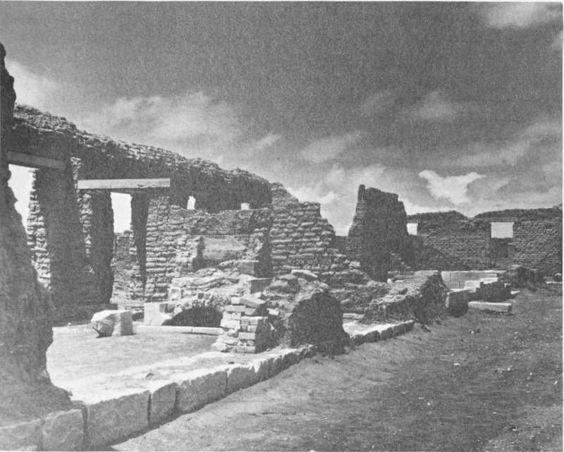
(Photo courtesy of National Park Service) Ruins of Fort Union
66
Fort Union was a community within itself and a lively social center. Weary travelers on the Santa Fe Trail eagerly anticipated their arrival. Few complaints were heard when soldiers were transferred to Fort Union, for this was a popular assignment.
With the coming of the railroad and peace at last descending on the frontier in the 1880’s, the need for the fort diminished. But it clung to life for a few more years, mainly because of the fond memories which lived in the hearts of the military leaders who had been stationed there. Finally, the end came and Fort Union was abandoned in February 1891.
New life came to the fort in 1955 when it became a National Monument. The ruins have been excavated and stabilized and a fine visitors’ center and museum has been established. Fort Union has at last assumed its rightful place as a shrine of history. Stand on the parade ground and survey the majesty that was Fort Union, listen for the sounds, the bugle calls, the barklike commands of close-order drill, the creak of wagons, and the thunder of horses’ hooves. These are the sounds of Fort Union. They are still there if one will only pause and listen.
Fort Marcy
Fort Marcy was established in 1846 at Santa Fe and was named for the then Secretary of War, W. L. Marcy. The fort was located on a hill overlooking the city some 1000 yards northeast of the plaza. A deep ditch or moat surrounded the massive adobe walls of the fort and a blockhouse, within musket range, protected the only entrance. At the time of Colonel Manfield’s inspection trip in August 1853, the troops were quartered in public buildings in Santa Fe, there being no quarters provided at the fort; however, it could be occupied on a moment’s notice. The original Fort Marcy was abandoned in 1867 and a new one was constructed a short distance to the west. This new site is now occupied by business and residential properties. The War Department abandoned Fort Marcy in October 1894, the troops and equipment being moved to Fort Sill, Oklahoma. The site was turned over to the city of Santa Fe in 1897.
Fort Marcy played an important role during the military occupation of New Mexico. It served as a base of operations against marauding Indians, was captured and occupied for a short time by Confederate forces in 1862, served as headquarters for the Ninth Military Department (changed to Department of New Mexico in 1853) throughout most of this period, and was a center for the social life of Santa Fe. Only low mounds of earth now mark the site of Fort Marcy.
Fort Wingate
Fort Wingate, at the site known today, was established in 1868. It is located on the site of a pre-existing fort at Ojo del Oso (Bear Springs) about twelve miles east of Gallup and three miles south of U.S. Highway 66.
Fort Fauntleroy was established in August 1860 and was named for the 67 then Department Commander, Col. T. T. Fauntleroy. The name was changed to Fort Lyon in September 1861 after Colonel Fauntleroy resigned his commission and joined the Confederate forces. The fort was abandoned in December 1861 as troops were concentrated at other posts to meet the threat of invasion of the territory by Confederate forces from the south. With the defeat of Confederate troops early in 1862, the military returned to the Indian problem and established a post some sixty miles to the east on the Rio de Gallo near San Rafael. This post was named Fort Wingate in honor of Capt. Benjamin Wingate who died of wounds received during the battle with the Confederate forces at Val Verde. The post proved to be too far from the Navajo country for effective control and, in 1868, was abandoned and a new Fort Wingate established at Ojo del Oso on the site occupied earlier by Fort Fauntleroy.
The physical plant of the new Fort Wingate consisted of barracks, officers’ quarters, hospital, guard house, storehouse, employees’ quarters, corrals, barns, and various repair and storage sheds, all bordering the traditional rectangular parade ground. Some of these buildings are in use today.
In 1914, 4000 Mexican refugees lived in a tent city at Fort Wingate until peace was restored after Pancho Villa’s revolution in Mexico. Following World War I, it became an ordnance storage depot, and new administrative and living quarters were built several miles west of the original fort enclosure. This installation is known today as Fort Wingate Ordnance Depot, and the long rows of concrete ammunition storage bunkers can be seen from U.S. Highway 66. In 1925, the original fort enclosure was transferred to the Department of the Interior for use as an Indian school. Today, the parade ground is a playground and the barracks are dormitories for the children who attend this school. The missile age came to Fort Wingate in 1963 when a portion of the military reservation became the launching site for test rockets which impact at the White Sands Missile Range 200 miles to the south.
Fort Wingate has seen many changes during its long and colorful history. It served well during its first 100 years and continues to serve today.
Fort Craig
Fort Craig was established in the spring of 1854 on the abandonment of Fort Conrad, nine miles north. It was named in honor of Col. L. S. Craig who was killed by an army deserter on June 6, 1852. The remains of Fort Craig are located on the west bank of the Rio Grande about thirty-four miles south of Socorro and five miles, by dirt road, east of U.S. Highway 85. The fort was established to afford protection against the many bands of Apaches that roamed this part of the territory.
Fort Craig was well built and became one of the best-garrisoned military posts in New Mexico. Built on the usual rectangular plan, the parade ground was bordered on the northeast by two double officers’ quarters; on the northwest by the guard house, prison room, and sallyport; on the southwest by three soldiers’ barracks each in the form of a hollow 68 square enclosing a patio; and on the southeast by various workshops, storerooms, stables, and corrals. The commanding officers’ quarters occupied the west corner of the parade ground and the hospital the east corner. Behind the commanding officers’ quarters there were three large bombproof storerooms. The entire installation was enclosed within a high wall, beyond which a ditch encircled the fort. Gun bastions projected from the north and south corners.
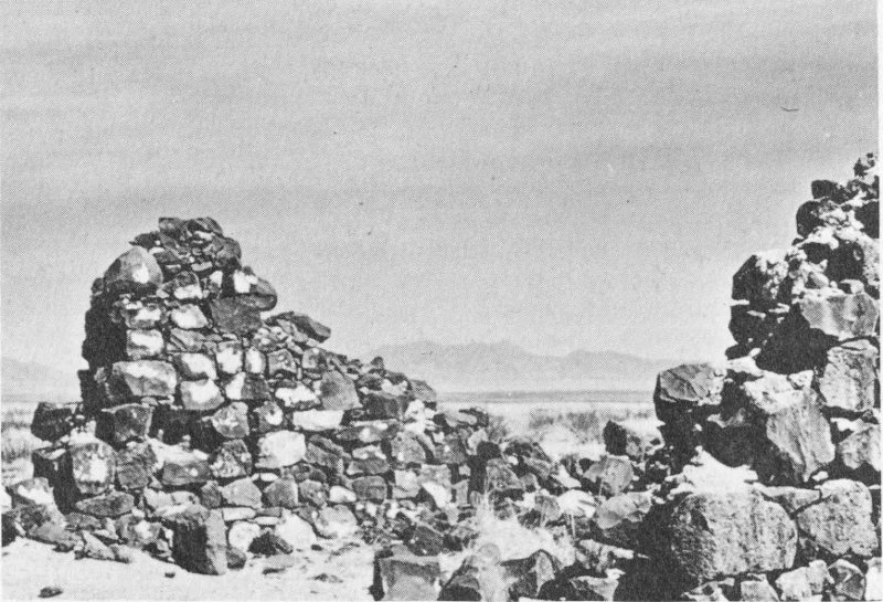
Remnants of guard house, Fort Craig (built of basalt blocks)
Fort Craig was one of the most important military posts in New Mexico. Its troops participated in many engagements with the Indian. In the fall of 1861, troops from other posts were concentrated at Fort Craig to meet the threatened invasion of Confederate forces from the south. In February 1862, these troops were defeated by the Confederate invaders in the battle of Val Verde which took place about four miles north of the fort. Upon the withdrawal of Confederate forces from the territory later in 1862, the troops at Fort Craig returned to the Indian problem. In March 1885, the fort was relinquished by the army and the improvements sold. The last soldier left in August 1885 after government property was removed and sent to Forts Bliss and Stanton. The buildings were sold at public auction on April 30, 1894, to the Valverde Land and Irrigation Company for $1070.50.
Fort Craig is now a ruin, but the outlines of most of the buildings can still be seen. Portions of the plastered walls of the commanding officers’ quarters remain, as do portions of the hospital and stone guard house. The 69 wall and ditch surrounding the fort, gun bastions, storehouses, and cemetery are still much in evidence. Coal marks the blacksmith’s shop and broken bottles the sutler’s store. Another frontier fort has passed into history.
Fort Stanton
Fort Stanton was established in May 1855 on the Rio Bonito at a site located approximately four miles east of present-day Capitan and three miles south of U.S. Highway 380. The fort was an attempt to control the Mescalero and White Mountain Apaches and was named for Capt. H. W. Stanton who had been killed by Apache Indians earlier that year. Many a soldier stationed at Fort Stanton gave up his life to an Apache during the Indian wars.
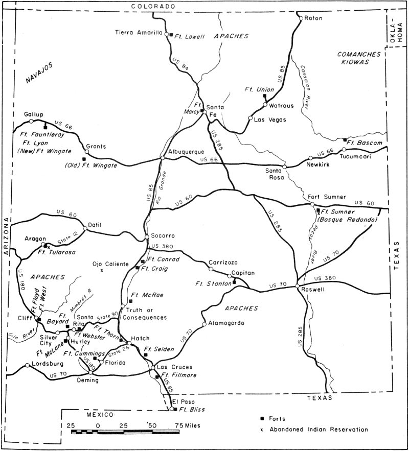
Map of New Mexico showing location of frontier forts
70
The original fort was little more than a stockade, with few buildings and little equipment. In August 1861, the government stores were burned and the troops moved to Albuquerque in the face of the Confederate invasion. Confederate troops occupied the site one month later but promptly left after a few encounters with the Apache. The site was reoccupied by Union troops October 1862 and, later, substantial buildings were erected, most of which still stand.
With the passing of the frontier, Fort Stanton was abandoned as a military post in August 1896, and in 1899, the installation passed to the U.S. Public Health Service for use as a merchant marine hospital for the treatment of tuberculosis. During World War II, a German prisoner of war camp was established at the fort. In 1953, the hospital was closed by the federal government because of the high cost of running the establishment. Fort Stanton is now a state tuberculosis hospital operated by the New Mexico Department of Public Welfare.
Col. Kit Carson used the fort as a base of operations while rounding up the Mescalero and White Mountain Apaches in late 1862 and early 1863. In 1881, the famous outlaw, Billy the Kid, was confined in the building now used as a dental clinic while on his way to the gallows in Lincoln, which never claimed him. Gen. John J. Pershing, as a young lieutenant, was stationed for a time at Fort Stanton.
Fort Selden
Fort Selden was established in 1865 and named for Capt. Henry R. Selden (later colonel) who distinguished himself at the battle of Val Verde, February 21, 1862. The fort was beside the Rio Grande nine miles north of the settlement of Doña Ana. The site is located along U.S. Highway 85 about seventeen miles north of present-day Las Cruces.
Fort Selden was one of a chain of forts established to control the Apaches. It was on the Butterfield Trail and provided protection for the government rope ferry which crossed the Rio Grande at nearby Leasburg. The summit of Mt. Robledo, across the river to the west, was used as a heliograph station, flashing messages between Fort Selden and Fort Bliss at Franklin (El Paso, Texas).
The buildings of the fort were one-story adobe structures with walls two feet thick. The installation included barracks for enlisted men, two double officers’ quarters, a ten-bed hospital, stone guard house, storehouses, workshop, bake shop, corrals, and a magazine with stone walls three feet thick. The fort was rectangular in ground plan, the buildings enclosing a parade ground.
Fort Selden was abandoned in 1879 when the railroads began to draw travel away from the overland trails. It was reoccupied in 1881 when the Apache Chiefs Victorio, Nana, and later Geronimo were on the warpath. With the passing of the Indian problem, Fort Selden was permanently abandoned in 1892. During World War I, the grounds of the fort were used for cavalry maneuvers by units stationed at Fort Bliss.
A rather famous American once lived at Fort Selden. Gen. Douglas 71 MacArthur, as a child of four, moved with his family to the fort in 1884, following the assignment of his father, then an infantry captain, to that post. The family remained at Fort Selden until late in 1886.
Now only crumbling adobe walls mark the site of Fort Selden, once a welcome sight to travelers in southern New Mexico. The wind, rain, and sun have taken their toll, aided in no small way by man himself. In 1963, through the efforts of the Doña Ana Historical Society, Fort Selden was made a State Monument by the New Mexico legislature. It is to be hoped that the fort will now be protected from further weathering and vandalism so that the remnants of this old outpost will stand for many years to come as a monument to the men who once manned it.
Fort Cummings
Fort Cummings was established in October 1863 in what is now Luna County, New Mexico. It was located at Cooke’s Spring, an important watering stop on the Butterfield Trail, at the eastern edge of Cooke’s Canyon. Prior to the establishment of Fort Cummings, the Apaches made frequent and fatal attacks upon travelers as they passed through the four miles of Cooke’s Canyon or stopped at the spring. Cooke’s Canyon was one of the most dangerous stretches on the Butterfield Trail. The fort was named for Maj. Joseph Cummings who was killed by Navajo Indians in August 1863. Its ruins can be reached by turning off State Highway 26 at Florida, sixteen miles northeast of Deming, and traveling seven miles to the west.
Fort Cummings was the most elaborate and best-walled fort in New Mexico. It covered an area 365 × 320 feet and was completely surrounded by a twelve-foot-high adobe wall. The main entrance was topped by a guard tower. Officers’ quarters occupied the west side of the parade ground, the hospital the north side, and soldiers’ quarters the east side. The various workshops, storerooms, offices, stables, and corrals extended along the south side of the fort.
Abandoned in August 1873, Fort Cummings was reoccupied in 1880, and then again abandoned in October 1886. Later it was used as a cattle corral by the Carpenter-Stanley Cattle Company. The spring was walled and covered, and the water piped to Florida.
Little remains of Fort Cummings today. A few weathered walls here and there among the mesquite and creosote bushes mark the site. The spring still flows, supplying water for the stock which now graze upon this “protector of the trail.”
Fort Bayard
Fort Bayard, established in 1865 to protect the miners and settlers moving into the area following the Civil War, allowed the orderly development of what was to become New Mexico’s most important mineral-producing area. Named for Capt. George D. Bayard who was wounded repeatedly during Indian forays and who died of wounds received in the Battle of Fredricksburg (Va.) during the Civil War, the fort was located 72 about five miles southeast of Pinos Altos and about midway between the mining towns of Pinos Altos and Santa Rita. The site is about nine miles east of present-day Silver City, just north of State Highway 90.
The original fort consisted of log and adobe buildings forming a square around the parade ground. During its thirty-four year history as an army post, many changes and additions were made to the fort, including the building of two-storied officers’ quarters. In 1899, the line troops were removed and the fort was officially designated as a U.S. Army General Hospital to treat tubercular soldiers. In 1920, the hospital was turned over to the Public Health Department; in 1922, to the U.S. Veterans Administration; and again, in 1966, to the State Health Department as a facility for the care of the aged and of tuberculosis cases. It can now accommodate more than 300 patients. The modern buildings are a far cry from the dirt-floored log and adobe buildings of the original fort.
HISTORY
Pre-Civil War Period.
The period 1846 to 1861 was characterized by constant Indian warfare. Treaties were made, then broken. Forts were established, then abandoned, and new forts built as the military tried in vain to cope with the problem. Punitive expeditions proved ineffective as the Indians separated into small and predatory bands which overran the country.
Forts Union, Marcy, Fauntleroy, Craig, and Stanton were established during this period. Additional forts, whose sites have returned to the desert, are Fort Conrad (1851), on the Rio Grande about twenty-five miles south of Socorro; Fort Thorn (1853), on the Rio Grande about five miles north of Hatch; Fort Fillmore (1851), on the Rio Grande about seven miles south of Las Cruces; Fort Webster (1852), on the Mimbres River about one and one-half miles northwest of San Lorenzo; Fort McLane (1860), at Apache Tejo about four miles south of Hurley; and Fort Floyd (1857), on the Gila River about two miles south of Cliff.
Civil War Period.
The outbreak of the Civil War in 1861 created a new problem on the frontier in New Mexico. Confederate military leaders moved quickly to seize control of the Southwest and California to cut off the supply of gold to the North and divert it to the Confederacy. Confederate troops under Col. J. B. Baylor occupied abandoned Fort Bliss at Franklin (El Paso), Texas on July 1, 1861. Baylor began his move northward along the Rio Grande on July 23 and quickly occupied Mesilla. Nearby Fort Fillmore was abandoned and the Union forces retreated toward Fort Stanton, but they were soon captured by Baylor’s troops. Upon the fall of Fort Fillmore, Fort Stanton was hastily abandoned on August 2 and was taken over by the Confederates shortly thereafter.
Gen. H. H. Sibley arrived at Fort Bliss in December 1861 to assume command of the Confederate forces. Sibley’s troops moved northward along the Rio Grande and were engaged in battle by Union troops from 73 Fort Craig, under Gen. E. R. S. Canby, as they attempted to bypass the well-garrisoned post. The Battle of Val Verde took place four miles north of Fort Craig on February 21, 1862. After a day of bloody fighting, Sibley emerged the victor. He occupied Albuquerque on March 2, 1862, and Santa Fe on March 23. The Confederate forces then moved toward Fort Union in an attempt to gain complete control of the territory. On March 27 and 28, they were met by Union forces sent out from Fort Union and were defeated in battle near present-day Glorieta. Sibley then retreated to Fort Bliss.
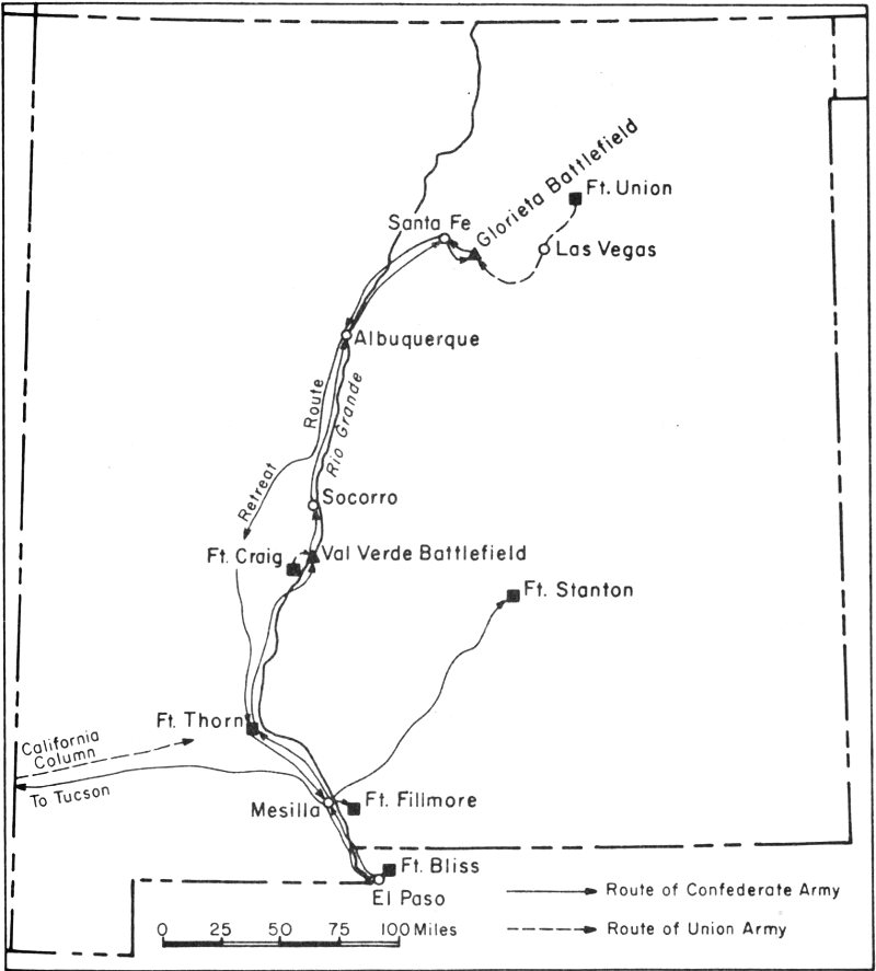
The Confederate campaign in New Mexico, 1861-1862
While Sibley was thus engaged, another part of his army moved across what is now southwestern New Mexico and southeastern Arizona and occupied Tucson (Arizona). Gen. J. H. Carleton and his California 74 Column left Los Angeles on April 13 and cleared this area of Confederate troops, reaching the Rio Grande on August 7. Carleton reoccupied Fort Bliss, which had been abandoned by the Confederate troops in their retreat.
Post-Civil War Period.
While the Union troops were preoccupied with the Confederates, the Indians stepped up their raids and depredations. With the passing of the Confederate threat, attention was once more focused on the Indian problem. A new plan was formulated which called for the capturing of the Indians and confining them to reservations. A reservation (Bosque Redondo) was established late in 1862 near present-day Fort Sumner, New Mexico, to which were eventually confined several thousand Navajos and Mescalero Apaches. This resettlement was not a success since the Apaches ran off and the Navajos suffered greatly from sickness and disease. A treaty was signed with the Navajos in 1868, and they were allowed to return to their homes, no longer a threat to the frontier. The Mescalero Apaches were finally settled on a reservation in their own country south of Fort Stanton, and the Jicarillas on a reservation west of Tierra Amarilla.
The Mimbreno, Mogollon, and Warm Springs Apaches of southwestern New Mexico were more of a problem. In 1871, a reservation and Fort Tularosa were established near present-day Aragon in western New Mexico. After a futile attempt to keep the Indians there, they were moved in 1874 to a new reservation and military post at Ojo Caliente, about forty miles northwest of present-day Truth or Consequences. This, too, proved a failure and the Apaches were moved to the San Carlos Reservation in what is now Arizona. During these attempts to locate the Apaches on reservations, various rebellious bands of Apaches led by Victorio, Nana, and Geronimo continued on the warpath. Geronimo and his band surrendered in 1886 and were imprisoned in Florida. After Geronimo’s surrender, relative peace descended upon the frontier in New Mexico.
Established in the post-Civil War period were Forts Wingate (old and new), Selden, Cummings, and Bayard, as well as Fort Lowell (1868), near Tierra Amarilla; Fort Bascom (1863), on the Canadian River about eight miles north of Tucumcari; Fort Sumner (1862), on the Pecos River about five miles southeast of present-day Fort Sumner; Fort McRae (1863), on the Rio Grande about ten miles northeast of Truth or Consequences; and Fort West (1863), on the Gila River about two miles south of Cliff.
With the arrival of the railroad and cessation of hostilities with the Indians, a new era was begun. One by one, the old forts were abandoned: their need had passed. The colorful frontier forts of New Mexico are just a memory now.
75