WEEK VII—NAVIGATION
Reading edition
TUESDAY LECTURE
Compass Error by an Azimuth
The easiest and most accurate way to find the error of your compass is, first, to find the bearing of the sun by your pelorus. If you set your pelorus, so that it will exactly coincide with the course you are steaming as shown by the compass in your chart house and then get a bearing of the sun by noting where the shadow from the pelorus vane cuts the circumference, this bearing will be the bearing of the sun by compass. At the same time, get your true bearing of the sun from the Azimuth Tables. The difference between the two will be the compass error, marked East or West according to the following rule which put in your Note-Book:
1. Express your Compass Bearing and your True Bearing by NEW compass reading.
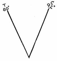
2. If TZ is to the right of CZ, C.E. is East. Formula: True - Right - East.
3. If TZ is to the left of CZ, C.E. is West. Formula: True - Left - West.
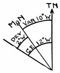
You must now remember that what you have is a Compass Error, consisting of both Variation and Deviation. To find the Deviation, the Variation and C.E. being given, is merely to apply the rules already given you under Dead Reckoning. For instance, if you had a C.E. of 10° W and a Variation of 4° E, the Deviation would be 14° W.
Put this example in your Note-Book:
LAT 20h 59m 57s Lat. 4° 55' N Dec. 10° 39' 30" N
Ship heading N 11° W. CB of (.) S 88° E. Variation 10° W. What was the ship's true course and Deviation of Compass on direction ship was heading?
CZ 92° (New compass reading) TZ 80° (New compass reading) —— CE 12° CE = 12° W Variation 10° W —— Deviation 2° W True course being sailed N 23° W or 337°.
Let us now work out some of the following examples:
1. L.A.T. 22h 14m 18s Lat. 30° 29' S Dec. 17° 28' 44" N Ship heading S 84° W Compass Bearing 44° Variation 10° W.
Required T.C. and Deviation on ship's loading.
2. August 29th, 1919. CT 2h 29m 18s A.M. Longitude 120° 19' 46" E. Latitude 44° 14' N. Ship heading 98°. Compass Bearing S 42° E. Variation 4° E.
Required T.C. and Deviation on ship's heading.
3. June 17th, 1919. CT 4h 18m 44s A.M. Longitude 60° 14' 59" E. Latitude 38° 48' 00" S. Ship heading SW x S. Compass Bearing 40° Variation 12° W.
Required T.C. and Deviation on ship's heading.
Etc.
WEDNESDAY LECTURE
Correcting Longitude by a Factor
We are now almost ready to begin the discussion of a day's work at sea. The only method we have not taken up is the one which is the subject of today's lecture. It is a method to correct your longitude to correspond with the difference between your latitude by Dead Reckoning and your latitude by observation.
Suppose you take a sight in the morning for longitude. The only latitude you can use is a D. R. latitude, advanced from your last known position. Now suppose you run until noon and at that time take a sight for latitude. In comparing your D. R. latitude, advanced the true course and distance steamed to noon, and your latitude by observation taken at noon, suppose there is a difference of several minutes. The question is—How can we correct our longitude to correspond with this error discovered in the latitude? This is the method which put in your Note-Book:
Find the difference between the latitude by D. R. and the corresponding latitude by observation (in most cases secured from a sight at noon or from the Star Polaris). Call this the Error in Latitude. With the D. R. Latitude of the preceding sight and the azimuth or bearing of the preceding sight (always expressed as a bearing of less than 90°, old compass reading) enter Table 47 for the correct Longitude Factor. Multiply this Factor by the Error in Latitude. The result is the correction to apply to the Longitude. It is applied East or West according as to whether the Latitude by Observation is to the East or West of the D. R. Latitude on the Line of Position (the line at right angles to the Azimuth) of the preceding sight.
Example:
Position about 7:30 A.M. Latitude by D. R. 25° 40' S, Longitude (just secured by observation) 104° 05' 38" E. L.A.T. 7h 32m 30s A.M., Declination 4° 59' N. Thence ship ran to noon 109°, true course, 46 miles, when the latitude by meridian altitude of the sun was found to be 25° 52' S. Required corrected longitude at noon.
7:30 A.M. D.R. Lat. 25° 40' S Lo. 104° 05' 38" E
109°—46 k. 15 S 48 18 E
————— ——————
Noon—Lat. by D.R. 25° 55' S Lo. 104° 53' 56" E
Noon—Lat. by obs. 25° 52' S
—————
Error in Lat. 3'
Enter Table 47 with azimuth (S 105° E) N 75° E as bearing and Latitude 25° 40' or 26°, Factor is found to be .3.
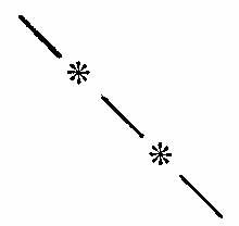
3' (Error in Latitude) times .3 (Factor) = .9' or 54", Correction in Longitude. Is it East or West? Since azimuth is N 74° E, Line of Position is N 16° W. The D. R. Latitude and Latitude by Observation are plotted on this line as follows:
Lat. by obs. (25° 52' S)
Lat. by D.R. (25° 55' S)
Latitude by observation is West of Latitude by D.R. Hence correction in longitude of 54" is applied West. Position by observation, therefore, is as follows:
Lo. 104° 53' 56" E
Corr. in Lo. 54 W
——————
Lo. by obs. 104° 53' 02" E
Lat. by obs. 25° 52' S
Note to Instructor:
Assign the following examples for work in the class room:
1. April 20th, 1919 A.M. at the ship. G.M.T. 20d 10h 28m 24s A.M. 31° 55' 40". HE 30 ft. No IE, CC. Latitude by D. R. 26° 30' N. Longitude 36° 55' West.

Ship then sailed a true course of S 36° E—40 knots until noon when observed altitude 75° 40' 50" S. What was the position at noon corrected for Longitude? (Note: Work the A.M. sight by both Time Sight and Marc St. Hilaire Method.)
2. June 25th, 1919, A.M. Latitude by D. R. 36° 20' S. Longitude 96° 30' E. CT 1h 37m 16s A.M. CC 1m 30s fast. IE 2' 30" off arc. HE 36 ft. 7° 34' 20". Log registered 114.
True course to noon S 76° E. Log registered 174. Same IE, HE, CC. Observed altitude 29° 44' 40" N. Required position at noon by Longitude factor. (Note: Work A.M. Sight by Marc St. Hilaire Method.)
3. At sea, May 30th, 1919. In D. R. Latitude 38° 14' 29" N. Longitude 15° 38' 49" W. Observed altitude 39° 05' 40" and bearing by compass 259°. IE 1' 00" on arc. HE 27 ft. WT 3h 04m 49s. C-W 1h 39m 55s. CC 1m 52s fast.
Changed course to 94° p.s.c. and steamed 75 knots to about 8 o'clock. WT 8h 06m 18s. C-W 1h 39m 58s. At this time observed altitude of Star Arcturus 68° 30' 40", East of meridian. Same IE, HE, CC.
Changed course to 95° (true). Steamed 60 knots until midnight when ran into heavy fog. Slowed down to 7 knots per hour until 8 A.M. when observed altitude 48° 45' 10". CT 9h 45m 18s A.M. Same HE, IE, CC.
Required fix at 8 A.M. by Marc St. Hilaire Method, laid down on chart.
Note to Instructor:
Spend rest of period in familiarizing pupils with laying down runs and intersecting lines of position on Mercator plotting charts.
THURSDAY LECTURE
The Navigator's Routine—a Day's Work at Sea
You are now familiar with the principal kinds of sights and the methods used in working them as explained in the foregoing pages. This information, however, relates only to each individual kind of sight. Today I will explain briefly how those sights are made use of in your daily work at sea. Such an explanation necessarily cannot include the navigator's work under all conditions and on all classes of ships. It merely gives a brief outline of and a few suggestions relating to navigating conditions on board a medium-sized transport, in time of war. I say "in time of war" because navigating then is different, to some extent, from the ordinary routine in time of peace.
Suppose you are ordered to a ship as navigator. What are your duties (a) before leaving port, (b) while at sea, and (c) on entering pilot waters?
(a) Before Leaving Port
Ascertain the height of the eye of the bridge and any other place on the ship where you would be likely to take sights.
Have posted in the chart room and on the bridge the deviation of the compass on each 15° heading, so that it can be easily referred to.
Keep in each chronometer case or in a book nearby the error and daily rate of all chronometers on board.
Test each sextant for index error and record the result where you can refer to it easily.
See that all charts of the harbor out of which you are to steam are corrected to date and are familiar to you, both as to sailing directions and buoys, and also as to lights and other aids to navigation.
Examine, in detail, the steering engine and steering apparatus. In case of its disarrangement your intimate knowledge of it may be most valuable.
See that the patent log and sounding machine are in good order. See that the lead lines are well soaked in water, stretched, and properly marked.
See that the lighting system in the chart room and the navigator's room is such that when any door is not tightly closed the lights in the room are extinguished. Likewise, when the doors are closed, see that the lights will light and without repeated slamming of the doors.
If possible, provide yourself with a flashlight set back in a metal tube so that the rays of the light are not diffused but can be focussed only on one spot at a time.
See that your charts are arranged neatly in the drawers provided for them in the chart room. If, as is usual, the charts must be folded to get them in the drawers, mark them legibly on the outside and in the same place on each chart. Put in the top drawers those charts you know you will use most frequently. This will save endless time and confusion.
Be sure you have a full complement of necessary instruments, including sextants, a stadimeter, binoculars, watches, stop watch, dividers, parallel rulers, pencils, work books; also all necessary books, such as smooth and deck log books, several volumes of Bowditch, Nautical Almanacs, Azimuth Tables, Pilot books, Light and Buoy lists, Star Identification Tables, etc. You will be repaid a thousand times for whatever effort you expend to have your navigational equipment complete to the smallest detail. The shortage, for instance, of a pair of dividers would be an unending annoyance to you. This is also true of almost any other item mentioned above. Prepare yourself, then, while you are in port and have plenty of opportunity to secure the equipment you desire.
(b) While at Sea
The least amount of work required of a navigator in time of peace would include (1) a morning sight for longitude, (2) a noon sight for latitude, (3) an afternoon sight for longitude, (4) an A.M. azimuth to check the deviation of the compass, and (5) the dead reckoning for the day's run from noon to noon.
Navigating in war time requires more work than this. If possible, the ship's position must be known accurately at any time of day or night for, in case of an emergency, the lives of all on board may be imperilled by inaccurate knowledge of your whereabouts. This means that more sights must be taken and more celestial bodies observed. While every navigator has his own idea as to the proper amount of work to do in a day, it would seem as though the following would cover the minimum amount of work necessary under present conditions:
1. An A.M. sight of the sun for longitude.
2. An azimuth of the sun for checking the deviation of the compass, taken right after the A.M. sun sight.
3. The watch time of Local Apparent Noon.
4. Ex-meridian and meridian altitudes of the sun for latitude.
5. A P.M. sight of the sun for longitude.
6. An evening twilight sight of three or four stars, preferably one in each quadrant. If these altitudes are taken correctly your position can be found to the dot.
7. A morning twilight sight for a fix or, at least, for latitude by Polaris.
8. The dead reckoning from noon to noon.
9. Distance run during the last 24 hours, from noon to noon
10. Distance to destination.
11. Set and drift of the current.
1. The A.M. Sun Sight
In order to make this a valuable sight for longitude it should be taken when the sun is on or as near as possible to the prime vertical. As the sun, in North latitudes, passes the prime vertical before sunrise in the winter, the following remarks do not hold for that season. In winter the only rule to follow is to observe the sun as soon as it is 10° or more above the horizon. In summer find out from the Azimuth Tables the local apparent time when the sun will bear 90°. Estimate, as closely as possible, the longitude you will be in the next morning when the local apparent time is as just found in the Azimuth Tables. This can be done by calculating the dead reckoning from the previous sight, or, what is even simpler, laying the distance off on the plotting chart. With this information find the W.T. corresponding to the L.A.T. mentioned above by some such formula as this: L.A.T. ± Lo. = G.A.T. ± Eq. T. (sign reversed) = G.M.T. ± C.C.(sign reversed) = C.T. - (C-W) = W.T. This will not be absolutely accurate, for the longitude you are in is only approximate, but it will be close enough for good results. This resulting W.T. will be the time to take the A.M. sight. About fifteen minutes before that time compare your watch with your chronometer to get the C-W. Also bring up the C.C. to date and make a note of it so that as much as possible of this detail work is accomplished before the sight is taken. Next, take your sextant and test it for index error. This should be done regularly before each series of sights as it is impossible to tell what may have happened when the sextant is lying idle, except by the above test. Now, with your sextant, watch and notebook, go to the place from which you have decided to take your observations and, at the proper watch time, start taking your altitudes. It is always advisable to take a number of sights, closely following each other, so that an error in one may be corrected somewhat by the others. Take at least three sights in close succession. At the same time have the log read and enter it in your notebook. An equally good method in fair weather is to secure the distance run from the revolutions of the propeller.
Having taken your sights, go to the standard compass and get a bearing of the sun, at the same time noting in your book the W.T. of the bearing and the compass heading of the ship. You are now ready to go below into the chart room and work out your position. What method shall you use? That depends upon your preference. You have missed the point of the previous lectures, however, if you forget that the New Navigation is based upon the Marc St. Hilaire Method, and this is undoubtedly the method your captain will prefer you to use if he is an Annapolis graduate. In this connection let me remind you again of the one fact, the oversight of which discourages so many beginners with the Marc St. Hilaire Method. The most probable fix, which you get by one sight only, is not actually a fix at all. Nor does any other method give you an accurate fix under like conditions. What the most probable fix is, and all it claims to be, is a point through which the required Sumner line is to be drawn. If your D.R. position happens to be only one mile away from the most probable fix, that is no assurance that the most probable fix is near the actual position of the ship. You may be 25 miles away from it. But the important information gained is that, though you may be 25 miles away, you know on what line you are, and when this line is later crossed with another line of position that fix will be accurate. "Two sights make a fix" is the whole matter in a nutshell.
2. The Compass Error
Having secured your morning sight, the next duty is to get the compass error. From your morning sight computation you know the watch time corresponding to the L.A.T. of the same sight. Find the difference between the two and apply this difference to the watch time of the compass azimuth. That will give you the L.A.T. with which to enter the Azimuth Tables to get the true bearing corresponding to the compass bearing recently observed. Apply the variation from the chart to get the magnetic bearing. The difference between this magnetic bearing and the compass bearing will be the required deviation, which you should compare with your Deviation Table. If there is a marked difference, and you are sure of your figures, use the new deviation in computing courses on this heading of the ship.
3. The Watch Time of Local Apparent Noon
You are now ready to figure the watch time of local apparent noon. Unless you have a decided preference to the contrary, do this by the method explained in the Saturday Lecture, Week VI. Do not forget that in subtracting the L.A.T. of the morning sight from 24 hours to get the total time to noon, in case the ship were stationary, you do not use the L.A.T. of the D.R. position, but the L.A.T. found by subtracting from G.A.T. the longitude of the most probable fix. This will give you the L.A.T., based on the longitude of the most probable fix, which will be slightly different from the L.A.T. based on the D.R. longitude. When you have secured the watch time of local apparent noon, subtract 30 minutes from it and notify the quartermaster that at that time by your watch the deck clocks are to be set to 11.30 A.M. If this change of time is very great (providing you are on an almost easterly or westerly course), it is wise to have the clocks set back in the night watches to allow for most of the time you figure you will lose. This will not work such a hardship or such an advantage to the officers and men who have the forenoon watch and will also be easier for the cooks. The clocks can then be slightly but accurately changed at 11.30 A.M., as mentioned above.
4. Ex-Meridian and Meridian Altitudes
You know the principles and methods governing sights of this character. To know your latitude exactly at noon is usually required when you are steaming in convoy, for at that time your position signals are hoisted, and it is a matter of pride with the navigator not only to have his position exact but promptly. If your A.M. sight was taken when the sun was on or near the prime vertical, a change in latitude at noon will make no change in longitude. Hence you can figure your longitude at noon just as soon as you have secured the corrected time from the A.M. sight to noon (which you have done right after working the A.M. sight). You will have your longitude, then, before you go on the bridge to observe for ex-meridian and meridian altitudes.
Sharply at noon you take your meridian altitude and tell a messenger to notify the captain that it is noon at the ship. The captain then orders eight bells struck, and you are ready to hand in your noon report, consisting of latitude and longitude by observation, latitude and longitude by dead reckoning, deviation of the compass on the ship's head at 8 A.M., distance made good since the preceding noon, distance to destination, set and drift of current (Note:—When steaming in convoy this is unnecessary and usually omitted), and any other pertinent remarks. If the sun was not taken on or near the prime vertical at the time of the A.M. sight, take out your longitude factor for the coming noon position and calculate your D.R. latitude at noon. By correcting the longitude of the A.M. sight, run to noon, with the difference of longitude, readily found at noon with the longitude factor and the error in latitude, you will have the correct noon longitude to hand in, with only a moment's delay. It will be very hard, however, to get all this information in on time without the use of latitude constants. There is no room for a discussion of these constants here, but they are easy to work and you should learn how to use them. The information is in Bowditch Art. 325, p. 128, and Art. 405, p. 181.
5. The P.M. Sun Sight
This is another longitude sight and so any previous remarks about sights of this character are applicable here. If the day is fine you need not work out this sight until after evening twilight, for a fix then by stars will give both latitude and longitude, whereas your afternoon sun sight will only give you a longitude. This P.M. sun sight is a good check sight, to be used or not, according as to whether other earlier or later sights have been obtained.
6. The Evening Twilight Sight
The beauty of using stars is that by almost simultaneous altitudes of different ones you can ascertain your position, both as to latitude and longitude. In the North Atlantic during the summer months Vega, Deneb or Altair in the East, Antares or Deneb Kaitos in the South, Arcturus in the West, and Polaris, Mizar, or Kochab in the North form an ideal combination which includes every quadrant of the compass. In the winter months, Capella, Castor or Pollux in the East, Sirius or any star in Orion's belt in the South, Deneb in the West, and Polaris in the North are equally as good.
7. The Morning Twilight Sight
In clear weather this should be primarily a sight for latitude, since the A.M. sun sight for longitude will follow it. A latitude by Polaris, and at the same time some star in one of the southern quadrants, as a check, will give admirable results.
8. The Dead Reckoning from Noon to Noon
If there is no change of course in the late forenoon, as is usually the case, the dead reckoning for the day's run can be figured any time before noon so that it will be all ready to hand in to the captain with the other noon data. It is much easier to lay this off on the chart than to go to the trouble of calculating it by Table 2, Bowditch. On the other hand, such a calculation checks the chart work and should be worked out if you wish to make "assurance doubly sure."
9. Distance Run During the Last 24 Hours
Here, again, an answer by chart and an answer by figures is a good thing to secure. As you become accustomed to your work you will find the answer by chart infinitely easier and quicker to get. It is just as accurate, too, if you lay the distances off carefully with the dividers and parallel rulers.
10. Distance to Destination
The same remarks as are made under (9) hold true here.
11. Set and Drift of Current
Find the difference between your D.R. position and your position by observation at noon, i.e., the course and distance from your D.R. position to your position by observation. The course is the set of the current, the distance the amount of drift, all of which is easily calculated by Table 2, Bowditch. This difference between the two positions is seldom due to current. It is due to all errors of steering and the like. But these are all ascribed to current, for the sake of convenience. This calculation of the current is seldom used now, particularly when steaming in convoy.
It is obvious that a schedule, such as outlined above, cannot be adhered to in all kinds of weather or under all conditions. It is merely an outline of what might properly be included in a 24 hour day, the weather conditions of which will lend themselves at any time to taking the observations mentioned. The weather of each succeeding day may force you to adopt a different routine. Nevertheless, the closer you can keep to the above schedule the more exact will your various positions be.
(c) On Entering Pilot Waters
See that all charts of the locality you intend to enter are corrected to date.
Study these charts carefully, making notes, in detail, of the aids to navigation that you intend to pick up.
In noting lights give their distinctive appearance, range of visibility, approximate time of sighting them, and any other information that you think you may need. If you have this information with you when on the bridge it will save much time and trouble that you would otherwise have to spend, at possibly a critical time, in the chart room.
See that log lines, sounding machine, etc., are in order for instant use.
Remember that in entering pilot waters the safest landmarks are permanent ones. Buoys, cans, etc., may drag from their positions or be lost altogether. This can also happen to lightships.
Become familiar with soundings, rise and fall of the tides, and the like, in the neighborhood in which you intend to anchor. If possible choose an anchorage that will enable you to get bearings from two or three fixed points on shore. As soon as possible after anchoring secure your bearings by pelorus and have them checked up by the quartermaster at regular intervals. This will determine how much, if any, dragging has taken place.
Lastly, always remember that no amount of advice can make up for your own carelessness. Hold yourself ready for any emergency, keep cool, keep patient and keep pleasant. Common sense is the best antidote in the world for strange situations. If you have that, and the knowledge you should have secured from these lectures, you cannot go far wrong.
While the day's work which follows does not include every sight in regular sequence as given in the above discussion, it will give a fair idea of the navigator's work during a day's run. Put it in your notebook. (Note to Instructor:—Spend the rest of the period in explaining carefully each step of this example.)
A Day's Work at Sea
Departure taken from noon position Jan. 25th, 1919, in Latitude 30° 01' N, Longitude 73° 47' 20" W. Course p.s.c. NE ¾ N. Deviation 2° E. Variation 4° W. Log registered 20. Ship continued on this course until about 6:30 P.M. when log registered 98 and observed altitude of Star Rigel, East of meridian, 39° 36' 20". WT 6h 33m 19s P.M. C-W 4h 55m 04s. CC 2m 16s slow. HE 37 ft. IE 0' 20" off arc.
Changed course to 40° (true) and steamed until 3 A.M. when log registered 198. At this time ship ran into heavy NE gale. Slowed down to 7 knots per hour until about 8:30 A.M. when observed 18° 25' 10" and bearing by compass S 46° E. Variation 7° W. WT 8h 31m 16s A.M. C-W 4h 55m 04s. IE + 0' 10". Same HE, CC.
Ship then steamed on true course of 39° at 7 knots per hour until noon when log registered 261 and observed meridian altitude 37° 59' S. Same IE (+ 0' 10"), HE, CC. Required:—
1. Position by D. R. at noon. 2. Position by observation at noon (corrected for Longitude by a factor). 3. Deviation of compass at 8:30 A.M. 4. Watch Time of Local Apparent Noon.
At Sea, Jan. 25, 1919. Lat. in 30° 01' N Lo. in 73° 47' 20" W Steamed until 6:30 P.M.
Course Dist. D. Lat. Dep. D. Lo.
N 35° E 78 63.9 44.7 51.5
Lat. Left 30° 01' N Lo. Left 73° 47' 20" W
D. Lat. 1 03 54 N D. Lo. 51 30 E
—————— ——————
Lat. in 31° 04' 54" N Lo. in 72° 55' 50" W
Mid Lat. 30° 30' N
At 6:30 P.M. Obs. * Rigel.
Obs. Alt. * 39° 36' 20"
IE + 00 20 W.T. 6h 33m 19s Log hav "t" 8.92502
—————— C.W. 4 55 04 Log cos Lat. 9.93269
39° 36' 40" C.C. 2 16 Log cos. Dec. 9.99544
HE - 7 09 —————— —————
—————— G.M.T. 11h 30m 39s Log hav S 8.85315 Nat hav S .07130
T.C.A. * 39° 29' 31" .R.A. 20 14 58 Nat hav L - D .11349

—————— .C.P. 1 53.3

Dec. of * 8° 17' 42" S —————— Nat hav ZD .18479
Lat. 31 04 54 N G.S.T. 31h 47m 30.3s 50° 55' 00" ZD
—————— - W.Lo. 4 51 43 -90 00 00
L. - D. 39° 22' 36" —————— ——————
—————— L.S.T. 2h 55m 47.3s 39° 05' 00" C. Alt.
*R. A. 5 10 41 39 29 31 T. Alt.
—————— ——————
"t" 2h 14m 54s 24' 31" Alt. Diff. Toward.
Course Dist D. Lat. Dep. D. Lo. S 45° E 24.5 17.3 17.3 20
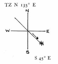
Lat. Left 31° 04' 54" N Lo. Left 72° 55' 50" W
17 18 S 20 E
—————— ——————
Lat. in 30° 47' 36" N Lo. in 72° 35' 50" W
Changed course to 40° (true)
Course Dist D. Lat. Dep. D. Lo.
N 40° E 138.5 106.1 89 105
Lat. Left 30° 47' 36" N Lo. Left 72° 35' 50" W
1 46 06 N 1 45 E
—————— ——————
Lat. in 32° 33' 42" N Lo. Left 70° 50' 50" W
At 8.30 A.M.
18° 25' 10" W.T 20h 31m 16s Log hav "t" 9.28284
IE + 10 C-W 4 55 04 Log cos Lat. 9.92573
————— C.C. 2 16 Log cos Dec. 9.97595
18° 25' 20" ————— ————
HE + 7 34 G.M.T. 1h 28m 36s Log hav S 9.18452 Nat hav S .15294
————— Eq.T - 12 32 Nat hav L-D .18841
18° 32' 54" ————— ———

G.A.T. 1h 16m 04s 71° 30' 00" ZD Nat hav ZD .34135
Dec. 18° 53' 24" S -W.Lo. 4 43 51 -90 00 00
Lat. 32° 33 42 N ————— —————
————— L.A.T.(t) 20h 32m 13s 18° 30' 00" C.Alt.
L-D 51° 27 06" 18 32 54 T.Alt.
—————
2' 54" Toward
Course Dist D. Lat. Dep. D. Lo. S 52° E 3 1.8 2.4 3
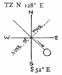
Lat. Left 32° 33' 42" N Lo. 70° 50' 50" W 1 48 S 3 E —————— —————— Lat. in 32° 31' 54" N Lo. Left 70° 47' 50" W
Bearing of Sun by Compass S 46° E
True Bearing of Sun S 52° E
———
Total Error 6° W
Variation 7° W
———
Deviation 1° E
Course Dist D. Lat. Dep. D. Lo. N 39° E 24.5 19 15.4 18.4
Lat. Left 32° 31' 54" N Lo. Left 70° 47' 50" W 19 N 18 24 E —————— —————— Lat. in 32° 50' 54" N Lo. in 70° 29' 26" W
At Noon.
37° 59' S L. A. T. 00h 00m 00s
IE + 10 + W. Lo. 4 41 58
—————— ——————
37° 59' 10" G.A.T. 4h 41m 58s
HE 8 55 E.T. (sign reversed) + 12 34
17 ——————
—————— G.M.T. 4h 54m 32s
38° 08' 22" S
51° 51' 38" N (ZD)
18 51 12 S (Dec.)
——————
33° 00' 26" N. Lat. in at Noon.
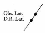
Lo. Factor = .93 Lat. by Obs. 33° 00' 26" N
Lat. Diff. 9.5 Lat. by D.R. 32° 50' 54" N
—— ——————
Diff. Lo. 8.83 Lat. Diff. 9' 32"
Since Obs. Lat. is East of D.R. Lat. on Line of Pos. Lo. Diff. is applied East.
Lo. by D.R. 70° 29' 26" W
Lo. Diff. 8 50 E
——————
Lo. in at Noon 70° 20' 36" W
By Dead Reckoning from Noon to Noon
Course Dist. D. Lat. Dep. D. Lo.
N 35° E 78 63.9 44.7 176' or 2° 56'
N 40° E 138.5 106.1 89.
N 39° E 24.5 19. 15.4
—— ——
189. 149.1
Lat. left. 30° 01' N Lo. left 73° 47' 20" W
3 09 N 2 56 E
———— ——————
Lat. in 33° 10' N Lo. in 70° 51' 20" W
Min. Lat. 31° 35'
The Watch Time of Local Apparent Noon
Date—Jan. 26, 1919
G.A.T. of A.M. Sight 1h 16m 04s Lo. in T. of A.M. sight 4 43 12 ————— L.A.T. 20h 32m 52s Total Time to Noon 3h 27m 08s Course to Noon — 39° Change in Lo. per hr. — 5.2', 21s 3600s + 21s = 3621s 3 x 60 = 180 27 —— 207 60 ——— 12,420 08 ———— 3621 ) 12,428 (3.43 hrs 10,863 ——— 15,650 14,484 ——— 11,660 10,863 ——— 3.43 hrs = 3h 25m 48s W.T. of A.M. sight 8 31 16 A.M. ————— W.T. of L.A.N. 11h 57m 04s A.M.
ANSWER. By D.R. Lat. 33° 10' N Lo. 70° 51' 20" W By Observation Lat. 33° 00' 26" N Lo. 70° 20' 36" W Dev. at 8:30 A.M. 1° E W.T. of L.A.N. 11h 57m 04s A.M.
FRIDAY LECTURE
Day's Work
At sea, November 28th, 1918. Departure taken at noon in Latitude 20° 50' N, Longitude 73° 15' 20" W. Log at noon registered 34. Sailed on course p.s.c. 73°, Deviation 3° E, Variation 1° W until twilight when log registered 152.
Changed course to E ¾ N p.s.c. and observed altitude of Star Aldebaran, East of meridian 37° 10' 10" and bearing by compass N 89° E, Variation 2° W. WT 8h 10m 16s. C-W 4h. 51m 30s. CC 4m 08s slow. IE 1' 10" off the arc. HE 38 ft.
Ship steamed on this course, in heavy fog and rain, until 2:30 A.M. when log registered 200. Ship changed course to E ½ N (true) and steamed at 8 knots per hour until 6:30 A.M. when weather cleared and observed altitude Star Polaris 21° 04' 20" N. WT 6h 35m 47s A.M. C-W 4h 51m 30s. Same IE, HE and CC.
Ship continued on same course and speed until about 9:30 A.M. when observed altitude of 38° 45' 20". WT 9h 39m 10s A.M. C-W 4h 51m 30s. Same IE, HE and CC.
Ship then steamed a true course of 93° at a rate of 10 knots per hour until noon when log registered 294 and observed meridian altitude 46° 49' 30". Same IE, HE and CC.
Required 1. D. R. position at noon. 2. Position by observation at noon (corrected for Longitude by a factor). 3. Deviation at 8:10 P.M. 4. Watch Time of Local Apparent Noon.
SATURDAY LECTURE
Day's Work
At sea, April 21st, 1918. Departure taken from noon position in Latitude 31° 50' N, Longitude 76° 30' 31" W. Log registered 128 at noon.
Course p.s.c. until about 4:30 P.M. was N 10° E. Deviation 1° W. Variation 3° W. At about 4:30 P.M. observed altitude of sun's lower limb 25° 13' 10" and bearing by compass N 87° W. WT 4h 26m 46s. C-W 5h 04m 52s. CC 1m 03s slow. IE 0' 10" off arc. HE 29 ft. Log registered at this time 188.
Course was then changed to NE x N (true). Weather cloudy. At about twilight clouds broke away and observed altitude of Star Procyon West of meridian 40° 01' 00". CT 1h 37m 28s A.M. CC 1m 03s slow. IE 0' 10" off arc. HE 29 ft. Log registered 236. Continued on same course until midnight, at which time log registered 290. At midnight ship ran into dense fog and slowed down to 8 knots until about 6:30 A.M., when fog blew away and observed altitude of Star Polaris 35° 29' 10" N. WT 6h 32m 14s A.M. C-W 4h 59m 02s. IE 0' 10" off arc. CC 1m 03s slow. HE 29 ft.
From 6:30 A.M. ship steamed a true course of N 32° E until noon at a rate of 15 knots per hour, at which time a meridian altitude of the was observed 65° 37' 10" S. Log registered 424. HE 29 ft. IE 0' 10" off arc. CC 1m 03s slow.
Required 1. D. R. position at noon. 2. Position by observation at noon (corrected for Longitude by a factor). 3. Deviation of Compass at 4:30 P. M. sight. 4. Watch Time of Local Apparent Noon.