Illustrations
Reading edition
“Something Hidden. Go and find it. Go and look behind the Ranges” Frontispiece
Sketch Map of Southern Peru 1
Mt. Coropuna from the Northwest 12
Mt. Coropuna from the South 24
The Base Camp, Coropuna, at 17,300 Feet 32 Photograph by H. L. Tucker
Camping at 18,450 Feet on the Slopes of Coropuna 32 Photograph by H. L. Tucker
One of the Frequent Rests in the Ascent of Coropuna 42 Photograph by H. L. Tucker
The Camp on the Summit 42 Photograph by H. L. Tucker
The Sub-Prefect of Cotahuasi, his Military Aide, and Messrs. Tucker, Hendriksen, Bowman, and Bingham inspecting the Local Rug-weaving Industry 60 Photograph by C. Watkins
Inca Storehouses at Chichipampa, near Colta 66 Photograph by H. L. Tucker
Flamingoes on Lake Parinacochas, and Mt. Sarasara 78
Mr. Tucker on a Mountain Trail near Caraveli 90
The Main Street of Chuquibamba 90 Photograph by H. L. Tucker
A Lake Titicaca Balsa at Puno 98Page xiv
A Step-topped Niche on the Island of Koati 98
Indian Alcaldes at Santa Rosa 114
Native Druggists in the Plaza of Sicuani 114
Laying Down the Warp for a Blanket; near the Pass of La Raya 120
Plowing a Potato-field at La Raya 120
The Ruins of the Temple of Viracocha at Racche 128
Route Map of the Peruvian Expedition of 1912 132
Lucre Basin, Lake Muyna, and the City Wall of Piquillacta 136
Sacsahuaman: Detail of Lower Terrace Wall 140
Ruins of the Aqueduct of Rumiccolca 140
Huatanay Valley, Cuzco, and the Ayahuaycco Quebrada 150
Map of Peru and View of Cuzco 158 From the “Speculum Orbis Terrarum,” Antwerp, 1578
Towers of Jesuit Church with Cloisters and Tennis Court of University, Cuzco 162
Glaciers Between Cuzco and Uiticos 170
The Urubamba Canyon: A Reason for the Safety of the Incas in Uilcapampa 176
Yucay, Last Home of Sayri Tupac 186
Part of the Nuremberg Map of 1599, showing Pincos and the Andes Mountains 198
Route Map of the Peruvian Expedition of 1915 202
Mt. Veronica and Salapunco, the Gateway to Uilcapampa 206
Grosvenor Glacier and Mt. Salcantay 210
The Road between Maquina and Mandor Pampa, near Machu Picchu 214
Huadquiña 220Page xv
Ruins of Yurak Rumi near Huadquiña 225 Plan and elevations drawn by A. H. Bumstead
Pucyura and the Hill of Rosaspata in the Vilcabamba Valley 238
Principal Doorway of the Long Palace at Rosaspata 242 Photograph by E. C. Erdis
Another Doorway in the Ruins of Rosaspata 242
Northeast Face of Yurak Rumi 246
Plan of the Ruins of the Temple of the Sun at Ñusta Isppana 248 Drawn by R. H. Bumstead
Carved Seats and Platforms of Ñusta Isppana 250
Two of the Seven Seats near the Spring under the Great White Rock 250 Photograph by A. H. Bumstead
Ñusta Isppana 256
Quispi Cusi testifying about Inca Ruins 268 Photograph by H. W. Foote
One of our Bearers crossing the Pampaconas River 268 Photograph by H. W. Foote
Saavedra and his Inca Pottery 288
Inca Gable at Espiritu Pampa 288
Inca Ruins in the Jungles of Espiritu Pampa 294 Photograph by H. W. Foote
Campa Men at Espiritu Pampa 302 Photograph by H. L. Tucker
Campa Women and Children at Espiritu Pampa 302 Photograph by H. L. Tucker
Puma Urco, near Paccaritampu 306
The Best Inca Wall at Maucallacta, near Paccaritampu 312Page xvi
The Caves of Puma Urco, Near Paccaritampu 312
Flashlight View of Interior of Cave, Machu Picchu 320
Temple over Cave at Machu Picchu; suggested by the Author as the Probable Site of Tampu-tocco 320
Detail of Principal Temple, Machu Picchu 324
Detail of Exterior of Temple of the Three Windows, Machu Picchu 324
The Masonry Wall with Three Windows, Machu Picchu 328
The Gorges, opening Wide Apart, reveal Uilcapampa's Granite Citadel, the Crown of Inca Land 338
Except as otherwise indicated the illustrations are from photographs by the author.
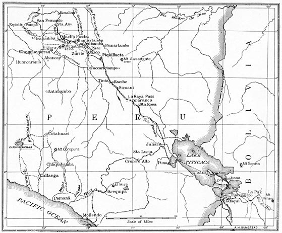
Sketch Map of Southern Peru.
Page 1