GEOLOGY
Reading edition
THE ORIGIN OF THE SCENIC FEATURES
The Island of Maui was built by two volcanoes. That forming West Maui is deeply dissected into several high peaks. The old summit crater now is encompassed by the head of Iao Valley. Mt. Kukui, the highest point, has an elevation of 5,788 feet.
East Maui is built of three series of lava products from Haleakala Volcano whose flows extended westward across the present isthmus to come to rest against the base of West Maui Volcano. These represent three great periods of activity, the latter two being separated by a long interval of quiescence that was characterized by intense erosion and mild, if any, eruptions. Geologists designate these three periods by the names Honomanu, Kula, and Hana. The mountain was built over three rifts, northerly, easterly, and southwesterly, each extending about fifteen miles.
In earliest (Honomanu) time, about the beginning of the Ice Ages, a symmetrical shield like Mauna Loa was built of pahoehoe and aa basalts 8,500 feet above present sea-level. During the next (Kula) cycle, eruptions were more explosive in nature; flows were composed of more viscous andesite between which layers of ash and soil accumulated. Big cinder cones and extensive ash beds were formed at this time. Like Mauna Kea today, the Honomanu dome was capped by a craterless mound of cinders, 2,500 feet high, that was studded with many lesser cones. The summit was a mile east of the present top on Red Hill and a thousand feet higher than it is today.
As Kula eruptions declined and grew less frequent, running water cut deeply into the sides of the mountain and excavated four great valleys, Keanae, Kaupo, Kipahulu, and Waihoi, that had broad heads, thousands of feet deep. Numerous lesser valleys were later to be buried more or less by lava flows. Most of the eastern summit ridge was worn away; Kaupo and Keanae Valleys met near the summit and fused into a great depression like that near the head of Iao Valley today. At one time, a great flow of mud, probably triggered by an earthquake, swept all before it as it moved down Kaupo Valley into 43 the sea. Its remnants today are 350 feet deep at Puu Maneoneo near the coastal road. A similar mass movement of rock on soft mud was started by an earthquake on April 2, 1868 at Wood Valley, west of the Kilauea Section of Hawaii National Park; the flow, in its precipitous descent, buried a village with 31 people and more than 500 head of stock.
In recent times, volcanism again quickened at Haleakala, giving the third (Hana) series of volcanics. This veneered the east and west slopes of the volcano, covered the floor of the depression, and pushed great lava flows through Koolau and Kaupo Gaps to the sea. Large flows and cones mask the divide that delimited the two great valleys. During Hana time, the northern rift alone remained inactive. The most recent activity, dated by Hawaiian legend as 1750, is represented by two bare, black flows above La Perouse Bay, the southwest corner of the island.
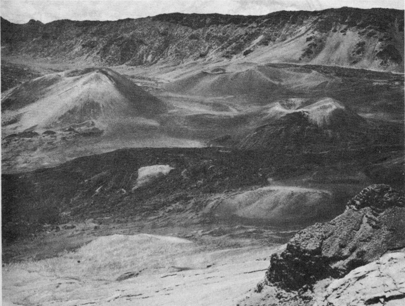
The Recent Cinder Cones.
Haleakala Crater, 7 miles long and 2½ miles wide, is locally proclaimed the largest extinct crater on earth, but the claim like the name is inaccurate. Nevertheless, it possesses a most unusual geological origin and beauty that give it a worthy place among the National Parks.
44
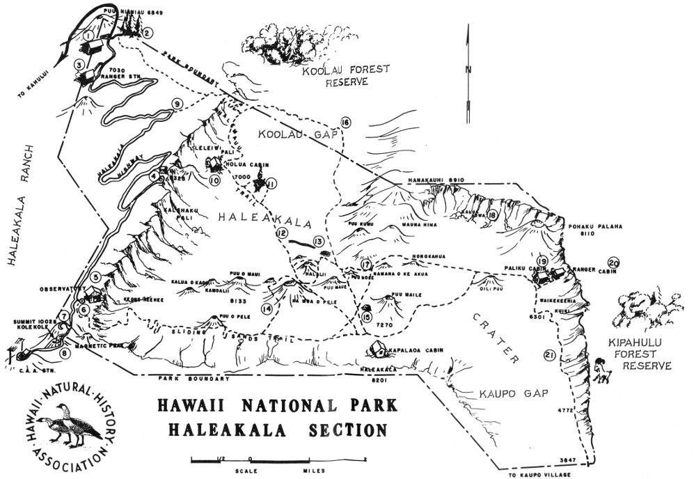
HAWAII NATIONAL PARK HALEAKALA SECTION
High-resolution Map
NUMBERED POINTS
1. PARK ENTRANCE; SILVERSWORD INN
2. HOSMER GROVE CAMPGROUND AND PICNIC AREA
3. ADMINISTRATION BUILDING, HAWAII NATIONAL PARK, HALEAKALA SECTION
4. KALAHAKU OVERLOOK; SILVERSWORD PLANTS
5. OBSERVATORY
6. WHITE HILL, START OF SLIDING SANDS TRAIL
7. RED HILL; SUMMIT OF HALEAKALA
8. SKYLINE DRIVE
9. START OF HALEMAUU TRAIL
10. HOLUA CABIN
11. SILVERSWORD LOOP
12. ANCIENT HAWAIIAN TRAIL
13. BOTTOMLESS PIT
14. KA MOA O PELE TRAIL
15. BUBBLE CAVE
16. WAIKAU CABIN
17. VOLCANIC DIKES; ANCIENT DIVIDE BETWEEN KOOLAU AND KAUPO RIVER VALLEYS
18. LAUULU TRAIL
19. PALIKU CABIN
20. KIPAHULU VALLEY
21. KAUPO TRAIL
KIPAHULU FOREST RESERVE
KOOLAU FOREST RESERVE
HALEAKALA RANCH
46
THE GEOLOGICAL INTERPRETATION
The summit depression of Haleakala stimulates speculation, and competent geologists have come up with widely differing hypotheses regarding its origin. In the account of their visit (see The Historical Background, p. 29), the first foreign visitors naturally used the term “crater,” which has been in vogue ever since. Pickering and Drayton of the Wilkes Expedition remark, “The crater of Haleakala, if so it may be called, is a deep gorge.”[10]
Drayton’s sketch was the first published map of the crater. James Dana, the great geologist with the Expedition, sailed past the mountain and later wrote a physiographic description based on notes made by Pickering and Drayton. In the official report, he expressed the idea, suggested by the crude map, that the mountain has been ripped apart by mighty convulsions that attended the most recent activity, so that the northeastern (Hana) part was separated along a zigzag crack from the rest of the mountain by the width of Keanae and Kaupo Valleys.[11] During the great eruptions that attended the rending, lava covered the floor and poured in great floods through Koolau and Kaupo Gaps.
W. D. Alexander, who surveyed the crater in 1869, believed: “... this is a real terminal crater, and not merely ‘a deep gorge open at the north and east’ or a caldera. I have indeed heard the theory proposed that the mountain is but a wreck of a complete dome with a small terminal crater, the whole top of which has fallen in and been carried away, as is supposed to have been the case with some of the volcanoes of Java, and the caldera of Palma.”[12]
C. E. Dutton, volcanologist of the United States Geological Survey, objected to Dana’s explanation and wrote that the depression is 47 “strictly homologous” to Kilauea Crater, that is, a collapsed caldera.[13] He assumed that this had been tapped by the upper ends of Keanae and Kaupo drainages. In 1887, Dana had opportunity to make a quick trip through the crater and down Kaupo Valley, so that he tempered his earlier opinion and decided that Keanae and Kaupo valleys might be graben.[14] Reginald Daly of Harvard rejected the hypothesis that the depression was like Kilauea Crater, since arcuate faults so prominent at Kilauea are apparently absent at Haleakala.[15] In his paper on petrography, Whitman Cross stated, “What is commonly called the crater of Haleakala appears to me to be, in some part at least, a result of erosion.”[16] At about the same time, Sidney Powers stated his belief that Kipahulu and Waihoi Valleys are graben, but he based his opinion on “authentic reports” and does not claim that he saw the valleys.[17]
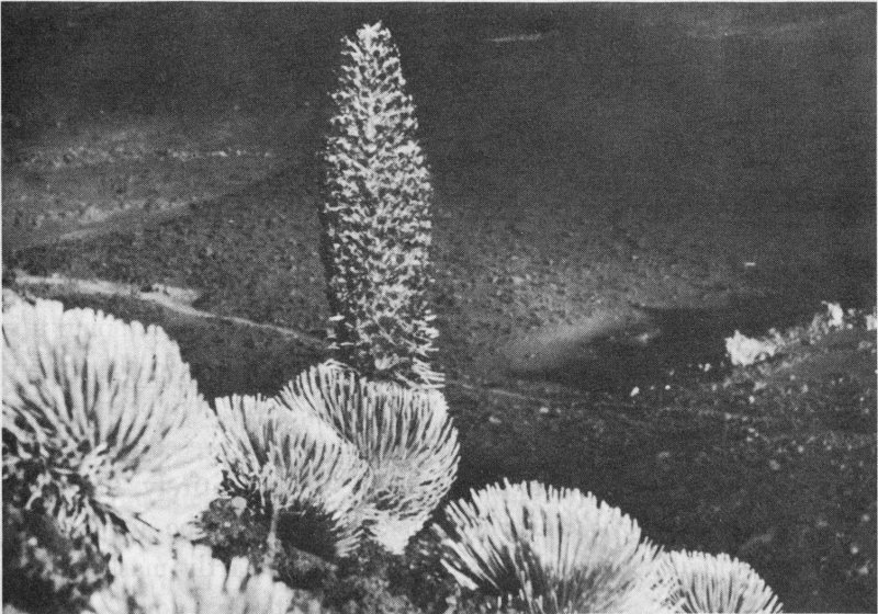
Ahinahina (silversword).
48
H. T. Stearns analyzed carefully all the supporting evidence and objections to the various viewpoints.[18] Of all of his profession, he made the most thorough field surveys, with the conclusion that the “crater” is chiefly erosional, affected by the recession of two great amphitheater-headed valleys, instead of by collapse, sliding away of the side of a cone, or explosion. Small craters may have existed at the time, but not a large one resembling the present depression. He believed that the big size results from the fact that the heads were offset and not in a straight line. The shape of the depression is what would result upon the fusion of two amphitheater heads similar to those of Waikoi, Kipahulu, and Manawainui valleys of today. Each of these is a typical Hawaiian valley, narrow at the base, but with a broad amphitheater at the head. Kipahulu is separated from Waihoi and from Kaupo Valleys by narrow divides. It can be assumed that a similar divide once separated the amphitheaters at the heads of the early Kaupo and Keanae drainages. Stearns further believes that once the rift zone was reached, stream erosion was greatly accelerated because of the loosely knit structure, the presence of many weak cinder cones, and the dike complex. This complex, as in other places in Hawaii, must have yielded perennial spring water to accelerate erosion. His summary is as follows:
“No stratigraphic or constructural evidence was found to support the hypothesis that Haleakala Crater is a true caldera, that it was formed by renting, or that Keanae and Kaupo valleys tapping this depression are grabens. Instead, detailed mapping and the examination of water tunnels show that Haleakala dome has been eroded by a number of great valleys. The hypothesis is presented that the so-called “crater” of Haleakala is chiefly, if not entirely, the result of the coalescence of the amphitheater heads of Kaupo and Keanae valleys and that renewed volcanic activity has partly masked their former divide and partly filled these valleys with lava flows.”
49
HALEAKALA PLANTS
Haleakala rises above the belt of warm trade winds into the cold, dry climate of the Alpine Zone. Temperatures at night may drop below freezing even in the warmer part of the year; the growing season is short and life is severe. The sparse plants that can live here crouch closely to the ground, diffusing or forming compact rosettes. All they have in which to grow are porous rocks and loose cinders that cannot hold moisture, lack organic matter, and do not yield a firm base for rooting. Species extending to lower elevations are here depauperate from wind and cold, although elsewhere they may attain a sturdy stature, even tree-size. Few seedlings are seen; individuals whose life span has finished remain conspicuous in death. Neither trees nor mats of shrubs are seen, but mosses and lichens find this Alpine desert to their liking. Oddly enough, one looks in vain for brilliant blossoms, such as one has come to expect in the high Sierra and the Rockies. The summit is a biological island on an oceanic island which, geological evidence indicates, never was part of a continent. The Hawaiian Chain was never near land of appreciable height and size.
How the Alpine plants came to Hawaii is uncertain since they have descended from ancestors so remote that past relationships are vague. The great Swedish botanist, Carl Skottsberg, believes that they are derived from a flora that grew on summits higher than any that exist today. Such assumption adds to the problem, as little else leads one to believe that elevations ever significantly exceeded 14,000 feet, i.e., the highest that exist today. In a report for the Fifth International Botanical Congress (Proceedings, pp. 91-97, Cambridge, 1931), Skottsberg listed 13 species found exclusively in the Alpine Zone, all of which are endemic, native to no other place than Hawaii’s highest volcanoes. Three other species listed as occurring in the Alpine Zone extend their range downward into the next lower Subalpine Zone, for which he has listed a total of 23 species, 20 of which he labels endemic. These adjoining zones are not sharply delimited, but blend into each other at 9,000 feet.
50
As elevation decreases and conditions for growth become better, the number of plant species increases. The Subalpine Zone with lower limits just above the park entrance has some of the most interesting plants found in the islands. Trees are absent but some of its shrubs extend their range to lower elevations and grow big, sometimes even to tree-size. Most Subalpine plants have small leaves or leaflets, indicating that lasting moisture is still scant. Occasional snowfall seldom remains long and never piles into drifts, which would conserve moisture.
Most of the interior of the crater is bare or thinly covered with vegetation. The uncongenial climate of the summit spills into it and extends throughout its length, though the elevation is much lower. Extensive aa flows, ash, and cinder cones cover the floor. Yet the crater has perhaps become best known through the presence of one of its plants, the silversword. Also, the lips of Koolau and Kaupo Gaps are botanically distinctive in contrast to the barreness elsewhere. This results from the fog and rain that sweep through them in late morning, only to dissolve upon mixing with the warmer air inside. As the day progresses, clouds push further and further inward, until, rarely, the whole depression may become filled. Koolau especially is a treasure-trove for the plant-lover. Below 6,000 feet, quite outside the park, it becomes impenetrable jungle surpassed only by that in Kipahulu Valley, a few miles east. Kaupo Cap is comparatively dry, but it supports a sparse scrub cover of great interest. The lower parts of Kaupo Valley are grazing land. Paliku is the only place within the park in which vegetation is lush. As it climbs Leleiwi Pali, Halemauu Trail is bordered by OHELO and ferns, among them AMAUMAU which is pleasing to the weary hiker’s eye.
In the northwestern angle of the park not far from the inn, Nianiau Crater has had a renowned floral character and history. Today it is overgrazed and drab. Dr. Joseph Rock, Hawaii’s famed dendrologist, discovered a curious tree lobelia, Clermontia haleakalensis, growing within it. He happily described the plant as “antediluvian in appearance.” This most primitive member of a distinctive Hawaiian floral group had a robust trunk from which clumsy, stubby branches shot off, each crowned with a feather-duster of long, thick, 51 strap-shaped leaves like some pompous dictator’s headdress. MAMANE and AKALA grew thickly around it; rarer associates included tree geraniums, Neurophyllodes sp., with flowers like violets, tree Railliardia, shrubby Hawaiian buttercups, and greensword, Argyroxiphium virescens, that is threatened with extermination by grazing to an extent greater than of its relative, the silversword.
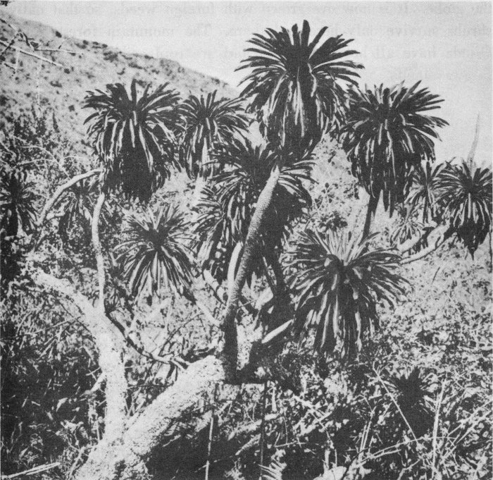
BISHOP MUSEUM, J. F. ROCK COLLECTION Clermontia Haleakalensis.
Even though they are outside the park, some plant communities on the outer slopes of the mountain should be mentioned, because they are related to park forms and carry a compelling interest. The trail from Olinda to Waikamoi is through a transition forest between the wet and the dry that once drew botanists from many parts of 52 the globe. It is now overgrown with foreign weeds, so that native shrubs survive only here and there. The mountain forests above Olinda have all been destroyed and are replaced by plants from faraway lands.
Although it now lies devastated by change, one of the richest botanical regions in Hawaii comprises the forbidding lava fields of Auwahi on the southwest slope of Haleakala. Fifty species of native trees once thrived in its fabulous mixed forests. The only known specimen of Maui hibiscadelphus, H. wilderianus, a relative of the hibiscus, was found here. It had a curved corolla that opened only slightly at the top. Its congener, H. giffardianus, once equally rare, still survives in Kipuka Puaulu at Kilauea, where a few vigorous plants, started by air-layering, receive tender care from the National Park. The last known Maui specimen of MAHOE, Alectryon macrococcus, grows in an Auwahi gulch. This tree has large double fruits (mahoe means twins) that split open to expose a shiny, chestnut-brown seed clasped in a brilliant scarlet aril. The ALANI, Pelea multiflora, of the lava fields is festooned with a lichen, Usnea australis, that appears to prefer it to all other trees. Haleakala sandalwood, Santalum haleakalae, with attractive red flowers grows to be a tree 25 feet tall. Other famous native trees include ’OHE’OHE, Tetraplasandra kauaiensis; ’OHE, Tetraplasandra meiandra; A’E, Fagara sp.; ’ALA’A, Planchonella auahiensis, with golden fruits; HO’AWA, Pittosporum terminalioides; OLOPUA, Nestegis sandwicensis; A’IA’I, Pseudomorus sandwicensis; MEHANE, Antidesma pulvinatum; and KAUILA, Alphitonia ponderosa, whose hard and durable timber was used in sacred structures.
Many unusual plants occur in the steep valleys to the north and east outside the park. Since the dense jungles in which they grow are inaccessible except to hardiest botanists, they are seldom seen. Here grow ’APE’APE, Gunnera petaloidea, a plant with geranium-like leaves three or more feet in diameter; a delicate, rare, native begonia, Hillebrandia sandwicensis; several exquisitely flowering lobelias. The summit bogs on Kukui and Mt. Eke in West Maui have a curious, distinctive flora that includes three species with origins ascribed to the Antarctic: Orebolus furcatus, a sedge; Acaena exigua of the Rose Family; and Lagenophora mauiensis, a composite.
53
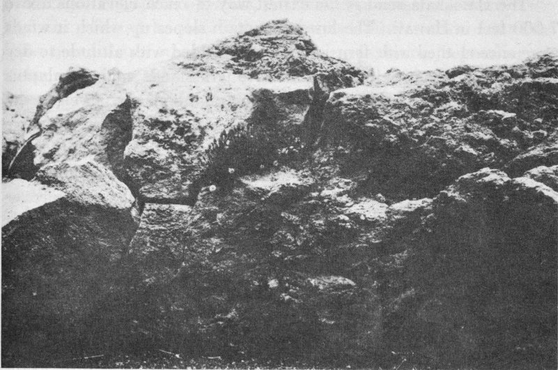
BISHOP MUSEUM, J. F. ROCK COLLECTION Tetromalopium.
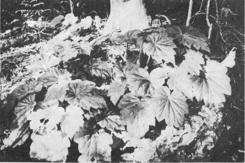
BISHOP MUSEUM, J. F. ROCK COLLECTION Begonia.
54
The Haleakala road is the easiest way to reach elevations above 7,000 feet in Hawaii. The lower mountain slopes up which it winds were once clothed with fern jungles that yielded with altitude to dry forest. All is now altered. Extensive grasslands and eucalyptus groves today leave the lasting impression on the visitor. Even on the heights, cattle, goats, introduced plants, insects, and other agents have wrought permanent change. Rare and interesting forms of native life have been exterminated or are well on the way to extinction. The National Park is trying hard to save what is left of the native cover within its boundaries and to restore the former scene wherever it is possible to do so.
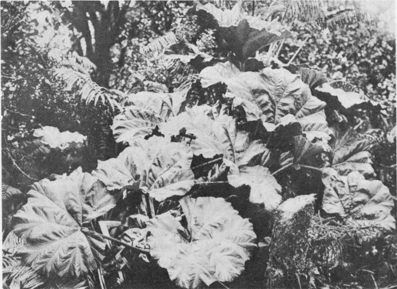
BISHOP MUSEUM, J. F. ROCK COLLECTION ’Ape’ape.
Plants of the distinctive Haleakala environment show differences, some slight, some considerable, from close relatives elsewhere. Examples are the OLAPA at Paliku, the silversword, and the KUPAOA. The differences have been fashioned by combinations of factors. The unstable, permeable ash and cinders have scant soil and little available mineral matter. They cannot hold water nor do they yield secure 55 anchorage. The effects of winds, isolation, exposure, and nature of terrain are reflected by the distorted shapes. Silversword, Artemisia, Bidens, and many other plants well show adaptation to peculiar environment. Why are some species found nowhere else? How did the plants get here in the first place and how have they changed with the passing of time? What has been the impact of exotics? What use did the Hawaiians make of the plants? To the hurried and casual visitor, the flora of Haleakala may appear drab and uninteresting. With better acquaintance, it becomes a stimulating study indeed.