INTRODUCTION. (continued 2)
Reading edition
lixThe maps upon which the supposition of the discovery is alone founded are all French, and that they are all repetitions, with slight variations, from one source, is shown by the fact that the inaccuracies are alike in all of them. But although the maps are in French, there are indications of Portuguese in some of the names, such as Terre ennegade, a Gallicized form of “Tierra anegada,” i.e., “land under water,” or “sunken shoal,” “Graçal,” and “cap de Fromose.” The question then arises, were the French or the Portuguese the discoverers? In reply, we present the following statement.
In the year 1529, a voyage was made to Sumatra, by Jean Parmentier of Dieppe, and in this voyage he died. Parmentier was a poet and a classical scholar, as well as a navigator and good hydrographer. He was accompanied in this voyage by his intimate friend the poet Pierre Crignon, who, on his return to France, published, in 1531, the poems of Parmentier, with a prologue containing his eulogium, in which he says of him, that he was “le premier François qui a entrepris à estre pilotte pour mener navires à la Terre Amérique qu’on dit Brésil, et semblablement le premier François qui a descouvert les Indes jusqu’à l’Isle de Taprobane, et, si mort ne l’eust pas prévenu, je crois qu’il eust été jusques aux Moluques.” This is high authority upon this point, coming as it does from a man of education, and a shipmate and intimate of Parmentier himself. The French, then, were not in the South Seas beyond Sumatra before 1529. The date of the earliest of our quoted lxmaps is not earlier than 1535, as it contains the discovery of the St. Lawrence by Jacques Cartier in that year; but even let us suppose it no earlier than that of Rotz, which bears the date of 1542, and ask, what voyages of the French in the South Seas do we find between the years of 1529 and 1542? Neither the Abbé Raynal, nor any modern French writer, nor even antiquaries, who have entered most closely into the history of early French explorations, as for example, M. Léon Guérin, the author of the Histoire Maritime de France, Paris, 1843, 8vo.; and of Les Navigateurs Français, 8vo., Paris, 1847, offer the slightest pretension that the French made voyages to those parts, in the early part or middle of the sixteenth century. Now we do know from Barros and Galvano that, at the close of 1511, Albuquerque sent from Malacca, Antonio de Breu, and Francisco Serrano, with three ships to Banda and Malacca: they passed along the east side of Sumatra to Java, and thence by Madura, Bali, Sumbava, Solor, etc., to Papua or New Guinea. From thence they went to the Moluccas and to Amboyna. See Barros, d. 3, l. 5, c. 6, p. 131, and Galvano, translated by Hakluyt, p. 378. Here we have the very islands, forming the northern portion of the Grande Jave, at this early date; but that which is totally wanting between this and 1529, is the account of the various explorations of the eastern and western coasts of the vast country described under that name. It is certain, moreover, that France was at that time too poor, and too much embroiled in lxipolitical anxieties, to busy itself with extensive nautical explorations. Had she so done, the whole of North America and Brazil might now have belonged to her. At the same time, however, we know that the Portuguese had establishments before 1529, in the East Indian Islands, and the existence of Portuguese names on the countries of which we speak, as thus delineated on these French maps, is in itself an acknowledgment of their discovery by the Portuguese, as assuredly the jealousy implied in the sentence quoted at p. vi of this introduction, from Pierre Crignon’s Prologue, would not only have made the French most ready to lay claim to all they could in the shape of discovery, but would have prevented any gratuitous insertion of Portuguese names on such remote countries, had they themselves discovered them.
But, further, as an important part of the argument, the reader must not overlook that jealousy of the Portuguese, to which allusion has already been made (p. v), in forbidding the communication of all hydrographical information respecting their discoveries in these seas. As regards the surmises of M. Barbié du Bocage respecting the probable causes of the suppression or concealment of such documents, his carefulness and ingenuity entitle them to the best consideration; and if those documents really exist in France, or Rome, or elsewhere, it is much to be hoped that they may ere long be brought to light. His Excellency the Count de Lavradio, ambassador from Portugal to the Court of St. James’s, has obligingly set lxiion foot inquiries at Rome for the purpose of elucidating this subject, which have not, however, produced any successful result.
But although we have no evidence to show that the French made any original discoveries in the South Seas in the first half of the sixteenth century, we have the evidence that they were good hydrographers. Crignon describes Parmentier as “bon cosmographe et géographe,” and says, “par luy ont esté composez plusieurs mapemondes en globe et en plat, et maintes cartes marines sus les quelles plusieurs ont navigué seurement.” It is dangerous to draw conclusions from negatives; but it is both legitimate and desirable that we should give due weight to evidence of high probability when such fall within our notice. If all the French maps we have quoted are, as has been shown, derived from one source, since they all contain the same errors; and if Parmentier, who was a good hydrographer, was the only French navigator we find mentioned as having gone so far as Sumatra before the period of the earliest of these maps; and further, if these maps exhibit Portuguese names laid down in these maps on a country beyond Parmentier’s furthest point of exploration, we think the inference not unreasonable that Parmentier may have laid down, from Portuguese maps, the information which has been copied into those we have quoted, and that the descriptions round the coast, which are all (as may be plainly seen), with the exception of those which bear the stamp of Portuguese, convertible into French, have lxiiibeen naturally written by French mapmakers, in that language. We can but throw out this suggestion for quantum valeat. All positive evidence, in spite of laborious research, is wanting. The Portuguese names are but few, but there they are, and bear their stubborn evidence. The earliest Portuguese portolani which have met the editor’s eye are those of Joham Freire, of 1546, and of Diego Homem, of 1558. Both these are silent on the subject. That of Lazaro Luis and of Vas Dourado, later in the century, both examined by Dr. Martin in Lisbon, are equally so. But this has been already accounted for. It is true that, in a mappemonde of the date of 1526, by one Franciscus, monachus ordinis Franciscanorum, copied into the atlas to the “Géographie du Moyen Age” of Joachim Lelewel, the great Terra Australis, extending along the south of the globe from Tierra del Fuego, is laid down with the words “Is nobis detecta existet,” and “hæc pars ore nondum cognita;” but this is plainly nothing more than a fanciful extension of Magellan’s discovery of the north coast of Tierra del Fuego, combined with the old supposition of the existence of a great southern continent.
A similar remark occurs in the manuscript portolano of Ioan Martinez, of Messina, of the date of 1567, in the British Museum; and in the fifth map of the portolano of the same hydrographer, of the date of 1578, is laid down “Meridional discoperta novamente,” with no names on it, and only shewing the north part. The extent of what is seen is twice as long as Java Major, which seems here to be lxivSumatra. It is observable that Petan and Maletur, names occurring on or near the Terra Australis of other maps of about this date, occur here, but close under Java Minor, which is a long way to the west of the “Meridional discoperta novamente.”
In 1526 the Portuguese commander, Don Jorge de Meneses, in his passage from Malacca to the Moluccas, was carried by currents and through his want of information respecting the route, to the north coast of Papua, which we now know as New Guinea; and in the following year we find Don Alvaro de Saavedra, a Spaniard, and kinsman of the great Cortes, despatched from New Spain to the Moluccas, and also lighting on New Guinea, where he passed a month; but nowhere in the allusions to these voyages do we find reference to the great southern land, which is laid down with so much detail under the name of “La Grande Jave.”
Our surmises, therefore, lead us to regard it as highly probable that Australia was discovered by the Portuguese between the years 1511 and 1529, and, almost to a demonstrable certainty, that it was discovered before the year 1542.
A notion may be formed of the knowledge possessed by the Spaniards in the middle of the sixteenth century, on the part of the world on which we treat, from the following extract from a work entitled, “El libro de las costumbres de todas las gentes del mundo y de las Indias.” Translated and compiled by the Bachelor Francisco Themara. Antwerp, 1556. “Thirty leagues from Java the Less is Gatigara, lxvnineteen degrees the other side of the equinoctial towards the south. Of the lands beyond this point nothing is known, for navigation has not been extended further, and it is impossible to proceed by land on account of the numerous lakes and lofty mountains in those parts. It is even said that there is the site of the Terrestrial Paradise.” Although this was not originally written in Spanish, but was translated from Johannes Bohemus, it would scarcely have been given forth to the Spaniards had better information on such a subject existed among that people.
It has been already stated at pages xvii and xviii of this Introduction, that in the early engraved maps of the sixteenth century, there occur apparent indications of Australia, with names and sentences, descriptive of the country so represented, derived from the narrative of Marco Polo, with an intimation that some of these representations may not have emanated solely from that narrative. The earliest of these occurs on a mappemonde in the third volume of the polyglot bible of Arias Montanus, and the indication of Australia there given is the more striking that it stands unconnected with any other land whatever, and bears no kind of description. It is simply a line indicating the north part of an unexplored land, exactly in the position of the north of Australia, distinctly implying an imperfect discovery, but not copied from, or bearing any resemblance to, any indication of the kind in any previous map with which the editor is acquainted.
lxviIn Thevet’s Cosmographie Universelle, Paris, 1575, is a map with Taprobane, La Grand Jave, Petite Jave, Partie de la Terre Australe; and in tom. i, liv. 12, the following passage:
“L’art et pratique du navigage est le plus pénible et dangereux de toutes les sciences, que oncques les hommes ayent inventées, veu que l’homme s’expose à la mercy des abysmes de ce grand ocean, qui environne et abbreuve toute la terre. Davātage, avec ceste Esquille lon peult visiter presque toute ce que le monde contient en sa rotondité, soit vers la mer glaciale, ou les deux poles, et terre Australe, qui n’est encor comme ie croy descouverte, mais selon mon opinion d’aussi grande estendue que l’Asie ou l’Afrique, et laquelle un iour sera recherchée par le moyen de ce petit instrument navigatoire, quelque long voyage qui y peust estre.”
In Dalrymple’s Hist. Coll. of Voyages in the South Pacific Ocean, Juan Fernandez is said to have discovered the southern continent. Burney, who speaks of his discovery of the southern continent (vol. i, p. 300), refers to the memorial of Juan Luis Arias for the description. See the first article in the present collection.
It is needless here to repeat the names and sentences already described at page xvii as given on early engraved maps from Marco Polo, but it will be well to notice such peculiarities as distinguish these maps from those in manuscript, which we have already been speaking of as probably representing Australia under the name of La Grande Jave. Such notice is the more interesting as the date of these engraved lxviimaps is intermediate between that of the manuscript documents and the period of the authenticated discovery of Australia. In the 1587 edition of Ortelius is a map entitled “Typus Orbis Terrarum,” in which New Guinea is made an island, with the words “Nova Guinea quæ an sit insula aut pars continentis Australis incertum.” On the Terra Australis, here brought up far more to the north than elsewhere, and separated from New Guinea only by a strait, are the words, “Hanc continentem Australem nonnulli Magellanicam regionem ab ejus inventore nuncupant.” While this sentence shows how indefinite was the idea of the extent of Australia towards the south, we think that the entire delineation, which brings the great Terra Australis so far northward in this longitude into connexion with New Guinea, goes far to show that Australia had really been discovered.
In various editions of Mercator occur copies of a map entitled, “Orbis Terræ Compendiosa descriptio quam ex magna universali Gerardi Mercatoris Rumoldus Mercator fieri curabat aº 1587,” in which similar indications are given to those in the map of Ortelius just described.
In the map of Peter Plancius, given in the English edition of the voyages of Linschoten, 1598, similar indications of Australia occur, but leaving the question of the insular character of New Guinea doubtful.
In the Speculum Orbis of C. de Judæis, Antwerp, 1592, is a map entitled “Brasilia et Peruvia,” on which occurs, “Chæsdia seu Australis Terra quam lxviiinautarum vulgus Tierra di Fuego vocant, alii Psittacorum Terram.” In the map of Asia, in the same volume, a tract is laid down which, by comparison with Ortelius’ map of the Pacific Ocean, is plainly New Guinea; and on both these maps, on the west coast of said tract, are the words, “Tierra baixa,” which seems to tally with “Baie Basse,” at about the corresponding point on the manuscript maps, and is confirmatory of the conclusion which the editor had formed, as stated on page xxvi. In the same volume is a map of the Antarctic hemisphere, in which the Terra Australis incognita is brought high up to the north in the longitude of Australia: on that part of it opposite the Cape of Good Hope is the following legend: “Lusitani bonæ spei legentes capitis promontorium, hanc terram austrum versus extare viderunt, sed nondum imploravere,” a significant sentence, if allowance be made for the difficulty at that time of reckoning the longitude.
In the map to illustrate the voyages of Drake and Cavendish by Jodocus Hondius, of which a fac-simile was given in The World Encompassed by Sir Francis Drake, printed for our Society, New Guinea is made a complete island, without a word to throw a doubt on the correctness of the representation; while the Terra Australis, which is separated from New Guinea only by a strait, has an outline remarkably similar to that of the Gulf of Carpentaria. These indications give to this map an especial interest, and the more so that it is shown to be earlier than the passage of Torres through Torres’ Straits in 1606, by its bearing lxixthe arms of Queen Elizabeth, before the unicorn of Scotland had displaced the dragon of England.
In the article “Terra Australis,” in Cornelius Wytfliet’s Descriptionis Ptolemaicæ Augmentum, Louvain, 1598, we find the following passage:—
“The ‘Australis Terra’ is the most southern of all lands, and is separated from New Guinea by a narrow strait. Its shores are hitherto but little known, since after one voyage and another, that route has been deserted, and seldom is the country visited unless when sailors are driven there by storms. The ‘Australis Terra’ begins at two or three degrees from the equator, and is maintained by some to be of so great an extent, that if it were thoroughly explored, it would be regarded as a fifth part of the world.”
The above significant statement was printed, it will be remembered, before any discovery of Australia of which we have an authentic account.
But while examining these indications of a discovery of Australia in the sixteenth century, it will be asked what explorations had been made by the Spaniards in that part of the world in the course of that century. From the period of the voyage of Don Alvaro de Saavedra to the Moluccas in 1527, already alluded to, we meet with no such active spirit of exploration on the part of the Spaniards in the South Seas. Embarrassed by his political position, and with an exhausted treasury, the emperor, in 1529, definitely renounced his pretensions to the Moluccas for a sum of money, although he retained his claim to the islands discovered by his subjects to the east of the line of demarcation now confined to lxxthe Portuguese. In 1542 an unsuccessful attempt to form a settlement in the Philippine Islands was made by Ruy Lopez de Villalobos, but its failure having been attributed to mismanagement, a new expedition in 1564 was despatched with the like object under Miguel Lopez de Legaspi, which was completely successful, and a Spanish colony was established at Zebu. It is not impossible that this settlement gave rise to voyages of discovery about this time by the Spaniards, of which no accounts have been published. In 1567 Alvaro de Mendana sailed from Callao on a voyage of discovery, in which he discovered the Solomon Islands and several others. There are great discrepancies in the different relations of this voyage. In 1595 he made a second voyage from Peru, in which he discovered the Marquesas, and the group afterwards named by Carteret Queen Charlotte’s Islands. The object of this expedition was to found a colony on the Solomon Islands, which he had discovered in his previous voyage, but from the incorrectness of his reckoning he was unable to find them. In the island of Santa Cruz he attempted to establish a colony, but without success, and in this island he died. In this second voyage he had for his chief pilot Pedro Fernandez de Quiros, who may be regarded as the last of the distinguished mariners of Spain, and whose name claims especial notice in a work treating of the early indications of Australia, although he himself never saw the shores of that great continental island.[7]
lxxiThe discovery of the island of Santa Cruz suggested to the mind of Quiros that the great southern continent was at length discovered, and in two memoirs addressed by him to Don L. de Velasco, viceroy of Peru, we meet with the first detailed argument upon this great geographical question, which, though he himself was not destined to demonstrate it by an actual discovery, may nevertheless be said to have been indirectly brought to a solution through his instrumentality. It is true that it is difficult in dealing with these vague surmises respecting the existence of a southern continent to draw distinctions between Australia itself and the great continent discovered in the present century, some twenty or thirty degrees to the south of that vast island. It has been already stated, p. xxxi, that Dalrymple, nearly two centuries later, earnestly advocated the same cause as De Quiros had done, and speaking of that navigator he says: “The discovery of the southern continent, whenever and by whomsoever it may be completely effected, is in justice due to this immortal name.” It should be premised that there are, in fact, three points of ambiguity in connexion with the name of that navigator, which it is well at once to state, as they might mislead the judgment of the superficial reader of the history of navigation of that period as to his connexion with the discovery of Australia. lxxiiIn the first place, though generally reputed to be a Spaniard, he is described by Nicolas Antonio, the author of the Bibliotheca Hispana, himself a Spaniard, and not unwilling, it may be supposed, to claim so distinguished a navigator for his countryman, as “Lusitanus. Eborensis, ut aiunt Lusitani” (a Portuguese, stated by the Portuguese to be a native of Evora), and the style of his writings bears out the supposition. Secondly, Antonio de Ulloa, in his Resumen, p. 119, quotes from an account of the voyage of Quiros, said to be given in the Historia de la Religion Serafica of Diego de Cordova (a work which the editor has not met with), the discovery of a large island in twenty-eight degrees south latitude, which latitude is farther south than Quiros or his companions are otherwise known to have made in any voyage. Thirdly, the printed memoirs of Quiros bear the title of Terra Australis Incognita, while the southern Tierra Austral, discovered by Quiros himself, and surnamed by him “del Espiritu Santo,” is none other than the “New Hebrides” of the maps of the present day.
At the same time, to both Quiros and Dalrymple we are indirectly indebted for the earliest designation which attaches in any sense to the modern nomenclature connected with Australia, viz., for the name of Torres Straits. That Quiros, whether by birth a Portuguese or a Spaniard, was in the Spanish service, cannot be doubted. The viceroy of Peru had warmly entertained his projects, but looked upon its execution as beyond the limits of his own power to lxxiiiput into operation. He therefore urged to Quiros to lay his case before the Spanish monarch at Madrid, and furnished him with letters to strengthen his application. Whether Philip III was more influenced by the arguments of De Quiros, as to the discovery of a southern continent, or rather by the desire to explore the route between Spain and America by the east, in the hope of discovering wealthy islands between New Guinea and China, we need not pause to question. It is possible that both these motives had their weight, for Quiros was despatched to Peru with full orders for the carrying out of his plans, addressed to the Viceroy, the Count de Monterey; and he was amply equipped with two well-armed vessels and a corvette, with which he sailed from Callao on the 21st of December, 1605. Luis Vaez de Torres was commander of the Almirante, or second ship, in this expedition. The voyage was looked upon as one of very great importance; and Torquemada, in his account of it in the Monarquia Indiana, says that the ships were the strongest and best armed which had been seen in those seas. The object was to make a settlement at the island Santa Cruz, and from thence to search for the Tierra Austral, or southern continent.
After the discovery of several islands, Quiros came to a land which he named Australia del Espiritu Santo, supposing it to be a part of the great southern continent. At midnight of the 11th of June, 1606, while the three ships were lying at anchor in the bay which they had named San Felipe and Santiago, lxxivQuiros, for reasons which are not known, and without giving any signal or notice, was either driven by a storm, or sailed away from the harbour, and was separated from the other two ships.
Subsequently to the separation, Torres found that the Australia del Espiritu Santo was an island, and then continued his course westward in pursuance of the exploration. In about the month of August, 1606, he fell in with a coast in 11½ degrees south lat., which he calls the beginning of New Guinea; apparently the south-eastern part of the land afterwards named Louisiade by M. de Bougainville, and now known to be a chain of islands. As he could not pass to windward of this land, Torres bore away along its south side, and himself gives the following account of his subsequent course. “We went along three hundred leagues of coast, as I have mentioned, and diminished the latitude 2½ degrees, which brought us into 9 degrees. From hence we fell in with a bank of from three to nine fathoms, which extends along the coast above one hundred and eighty leagues. We went over it, along the coast, to 7½ south latitude; and the end of it is in 5 degrees. We could not go further on for the many shoals and great currents, so we were obliged to sail south-west, in that depth, to 11 degrees south lat. There is all over it an archipelago of islands without number, by which we passed; and at the end of the eleventh degree the bank became shoaler. Here were very large islands, and there appeared more to the southward. They were inhabited by black people, very corpulent and lxxvnaked. Their arms were lances, arrows, and clubs of stone ill fashioned. We could not get any of their arms. We caught, in all this land, twenty persons of different nations, that with them we might be able to give a better account to Your Majesty. They give much notice of other people, although as yet they do not make themselves well understood. We were upon this bank two months, at the end of which time we found ourselves in twenty-five fathoms, and 5 degrees south latitude, and ten leagues from the coast; and, having gone four hundred eighty leagues here, the coast goes to the north-east. I did not search it, for the bank became very shallow. So we stood to the north.”
The very large islands seen by Torres in the 11th degree of south latitude, are evidently the hills of Cape York; and the two months of intricate navigation, the passage through the strait which separates Australia from New Guinea. A copy of this letter of Torres was fortunately lodged in the archives of Manilla; and it was not till that city was taken, in 1762, by the English, that the document was discovered by Dalrymple; who paid a fitting tribute to the memory of this distinguished Spanish navigator, by giving to this dangerous passage the name of Torres’ Straits, which it has ever since retained. The editor has striven in vain to learn into whose hands Dalrymple’s copy of this letter has fallen. He has been compelled, therefore, to reprint it from Dalrymple’s translation, supplied to Admiral Burney, as inserted at the end of vol. ii of his Discoveries and Voyages in the South Sea.
lxxviDe Quiros himself reached Mexico on the 3rd of October, 1606, nine months from his departure from Callao. Strongly imbued with a sense of the importance of his discoveries, he addressed various memoirs to Philip III, advocating the desirableness of further explorations in these unknown regions; but, after years of unavailing perseverance, he died at Panama in 1614, leaving behind him a name which for merit, though not for success, was second only to that of Columbus; and with him expired the naval heroism of Spain. “Reasoning,” as Dalrymple says, “from principles of science and deep reflection, he asserted the existence of a southern continent; and devoted with unwearied though contemned diligence, the remainder of his life to the prosecution of this sublime conception.” In the first document printed in this collection, which is from the hand of the Fray Juan Luis Arias, is given an account of his earnest advocacy of the resuscitation of Spanish enterprise in the southern seas, and especially with reference to the great southern continent.
But while the glory of Spanish naval enterprise was thus on the wane, the very nation which Spain had bruised and persecuted was to supplant her in the career of adventure and prosperity. The war of independence had aroused the energies of those provinces of the Netherlands which had freed themselves from the Spanish yoke; while the cruelties perpetrated in those provinces which the Spaniards had succeeded in again subduing, drove an almost incredible number of families into exile. The majority of lxxviithese settled in the northern provinces, and thus brought into them a prodigious influx of activity. Among these emigrants were a number of enterprising merchants, chiefly from Antwerp,—a town which had for many years enjoyed a most considerable, though indirect, share in the transatlantic trade of Spain and Portugal, and was well acquainted with its immense advantages. These men were naturally animated by the bitter hatred of exiles, enhanced by difference of faith and the memory of many wrongs. The idea which arose among them was, to deprive Spain of her transatlantic commerce, and thus to cripple her resources, and strengthen those of the Protestants, and by this means eventually to force the southern provinces of the Netherlands from their oppressors. This idea, at first vaguely entertained by a few, became general when the Spaniards forbad Dutch vessels to carry on any traffic with Spain. This traffic had existed in spite of the wars, and had furnished the Dutch with the principal means of carrying it on.
Being thus violently thrust out of their share in transatlantic commerce, the Dutch determined to gain it back with interest. Geography and hydrography now became the subjects of earnest study and instruction; and the period was distinguished by the appearance of such men as Ortelius, Mercator, Plancius, De Bry, Hulsius, Cluverius, etc., whom we are now bound to regard as the fathers of modern geography. Among these the most earnest in turning the resources of science into a weapon against the oppressors lxxviiiof his country, was Peter Plancius, a Calvinist clergyman, who opened a nautical and geographical school at Amsterdam for the express purpose of teaching his countrymen how to find a way to India, and the other sources whence Spain derived her strength. We do not here dwell on their efforts to find a northern route to the east. Their knowledge of the direct route to that wealthy portion of the world had become greatly increased by the appearance of Jan Huyghen van Linschoten’s great work. (Amst., 1595–96.) Linschoten had, for fourteen years, lived in the Portuguese possessions in the East, and had there collected a vast amount of information. The Dutch East India Company was established in 1602; and in 1606 we find a vessel from Holland making the first authenticated discovery of that great south land which in our own time has been designated—at the suggestion of that worthy navigator, Matthew Flinders, to whom we are so largely indebted for our knowledge of the hydrography of that country—by the distinct and appropriate name of Australia.
Of the discoveries made by the Dutch on the coasts of Australia, our ancestors of a hundred years ago, and even the Dutch themselves, knew but little. That which was known was preserved in the Relations de divers voyages curieux of Melchisedech Thevenot (Paris, 1663–72, fol.); in the Noord en Oost Tartarye of Nicolas Witsen (Amst., 1692–1705, fol.); in Valentyn’s Oud en Nieuw Oost Indien (Amst., 1724–26, fol.); and in the Inleiding tot de algemeen Geographie lxxixof Nicolas Struyk (Amst., 1740, 4to.). We have, however, since gained a variety of information through a document which fell into the possession of Sir Joseph Banks, and was published by Alexander Dalrymple, at that time hydrographer to the Admiralty and the East India Company, in his collection concerning Papua. This curious and interesting document is a copy of the instructions to Commodore Abel Jansz Tasman for his second voyage of discovery. That distinguished commander had already, in 1642, discovered not only the island now named after him, Tasmania (but more generally known as Van Diemen’s Land, in compliment to the then governor of the Dutch East India Company at Batavia), but New Zealand also; and, passing round the east side of Australia, but without seeing it, sailed on his return voyage along the northern shores of New Guinea. In January 1644 he was despatched on his second voyage; and his instructions, signed by the Governor-General, Antonio Van Diemen, and the members of the council, are prefaced by a recital, in chronological order, of the previous discoveries of the Dutch. The document is reprinted in the present volume.
From this recital, combined with a passage from Saris, given in Purchas, vol. i, p. 385, we learn that, “On the 18th of November, 1605, the Dutch yacht, the Duyfhen (the Dove), was despatched from Bantam to explore the islands of New Guinea, and that she sailed along what was thought to be the west side of that country, to 19¾° of south latitude.” This extensive country was found, for the greatest part, desert; lxxxbut in some places inhabited by wild, cruel, black savages, by whom some of the crew were murdered; for which reason they could not learn anything of the land or waters, as had been desired of them; and from want of provisions, and other necessaries, they were obliged to leave the discovery unfinished. The furthest point of the land, in their maps, was called Cape Keer Weer, or “Turn Again.” As Flinders observes, “the course of the Duyfhen from New Guinea was southward, along the islands on the west side of Torres’ Strait, to that part of Terra Australis a little to the west and south of Cape York. But all these lands were thought to be connected, and to form the west coast of New Guinea.” Thus, without being conscious of it, the commander of the Duyfhen made the first authenticated discovery of any part of the great south land about the month of March 1606; for it appears that he had returned to Banda in or before the beginning of June of that year.
The second expedition mentioned in the Dutch recital for the discovery of the great south land, was undertaken in a yacht in the year 1617, by order of the Fiscal d’Edel, “with little success,” and the journals and remarks were not to be found; but various ships outward bound from Holland to the East Indies, in the course of the years 1616, 1618, 1619, and 1622, made discoveries on the west coast of the great unknown south land, from 35° to 22° south latitude, and among them the ship Eendragt (the Concord), commanded by Dirk Hartog, Hertoge, or Hartighs, of Amsterdam, fell in with land in lxxxiabout 25 degrees south, which afterwards received its name from this ship. The president, De Brosses, has fallen into the error of describing Dirk Hartog, as a native of Eendragt, adding that this coast has preserved the name of the vessel, and that of the country of its commander. The Dutch recital which mentions the voyage of the Eendragt, does not give Hartog’s name, but we learn it from a MS. chart by Hessel Gerritz, of Amsterdam, 1627, referred to by Dalrymple in his collection concerning Papua, note, page 6. An important part of Hartog’s discovery was Dirk Hartog’s Roads, at the entrance of the sound, afterwards called by Dampier Shark’s Bay, in 25°; and on Dirk Hartog’s island, one of the islands forming the road, he left a tin plate, bearing the following inscription: Aº. 1616 den 25sten October is hier vangecomen het schip de Endracht van Amsterdam, den Oppercoopmen Gilles Mibais Van Luyck, Kapitein Dirk Hartog, van Amsterdam, den 27sten. dito t’ zeijl gegaen na Bantam, den Ondercoopman Jan Stoyn, Opperstiermann Pieter Dockes van Bil Aº. 1616. Of which the following is a translation: On the 25th of October, 1616, arrived here the ship Endraght, of Amsterdam: the first merchant, Gilles Mibais Van Luyck; Captain Dirck Hartog, of Amsterdam; the 27th ditto set sail for Bantam; undermerchant, Jan Stoyn; upper steersman, Pieter Dockes, from Bil. Aº. 1616.
In 1697, this plate was found by Wilhem Van Vlaming, Captain of the Geelvink, of whose voyage we shall have to speak in due course, and was lxxxiireplaced by another on which the inscription was copied, and the following new inscription added:
1697. den 4 den Februarij is hier aengecomen het schip de Geelvinck van Amsterdam, den commandeur schipper Williem de Vlamingh van Vlielandt: Adsistent Joan van Bremen van Coppenhage; Opperstierman Michiel Blom van Estight van Bremen.
De Hoecker de Nijptang, schipper Gerrit Collaert van Amsterdam; Adsistent Theodorus Heermans van do.; d’opper-stierman Gerrit Gerritz van Bremen.
’t Galjoot t’ Weseltje, Gezaghebber Cornelis de Vlamigh van Vlielandt; stierman Coert Gerritsz van Bremen, en van hier gezeilt met ons vloot den 12 do. voorts het Zuijtlandt te ondersoecken en gedestineert voor Batavia.
Of which the following is a translation: On the 4th of February, 1697, arrived here the ship Geelvinck, of Amsterdam: captain commandant, Wilhelm van Vlaming of Vlielandt; assistant, Jan van Bremen of Copenhagen; first pilot, Michéel Bloem van Estight of Bremen; the hooker the Nyptangh, captain Gerrit Collaert of Amsterdam; assistant, Theodorus Heermans of the same place; first pilot, Gerrit Gerritz of Bremen; then the galliot Weseltje; commander, Cornelis van Vlaming of Vlielandt; pilot, Coert Gerritzs of Bremen. Sailed from here with our fleet on the 12th, to explore the south land, and afterwards bound for Batavia.
In the account of the voyage of discovery made to the south by the corvettes, Geographe and Naturaliste, lxxxiiiin the years 1800, 1801, 1802, 1803, and 1804, published by F. Peron, vol. i, chap. 10, p. 193, we find, that in the month of July 1801, Captain Hamelin, of the Naturaliste, resolved on sailing to the extremity of Shark’s Bay; but he first dispatched three men to Dirck Hartog’s island, for the purpose of signalizing the Geographe, in case it should heave in sight at the entrance of the bay. On returning from Dirck Hartog’s island, the boatswain brought with them the plate of tin above described. It was about six inches diameter, and the inscriptions were described as coarsely cut. The plate was found on the north point of the island, which was named in consequence, the Cape of the Inscription; it was then half covered with sand, lying near an oaken post, on which it seemed to have been originally nailed. Having copied the inscriptions, Captain Hamelin had a new post made, and sent back the plate to be refixed on the same spot from which it had been taken; he would have looked upon it as sacrilege to have kept on board this plate, which, for nearly two centuries, had been spared by nature, and by those who might have observed it before him. He himself also placed on the north-east part of this island a second plate, on which were inscribed the name of his corvette, and the date of his arrival on those shores. In the translation given in Peron’s work of the earlier of these two inscriptions, a droll mistake is made by an error in punctuation, as will be seen by comparing the original inscription, see p. lxxxi, with the following: “1616. Le 25 Octobre lxxxivest arrivé ici le navire l’Endraght d’Amsterdam: premier marchand, Gilles Miebais Van Luck; capitaine, Dirck Hartighs d’Amsterdam; il remit sous voile le 27 du même mois; Bantum étoit sous marchand; Janstins premier pilote: Pieter Ecoores Van-Bu ... Anne 1616.”
Thus it will be seen, that Bantam, in Java, for which they set sail, is transformed into the undermerchant, and the person who really held that post is converted into chief pilot, while poor Pieter Dockes, whose name, perhaps more feebly scratched at the close of the inscription, had become obliterated by more than a century’s rough usage, is deprived of the honour of holding any post whatever. Even this rendering of the inscription is however highly interesting, as giving some indications of the degree of obliteration effected by the weather in this long space of time.
In 1617 appeared a work, the title of which renders some mention of it in this place necessary. It was entitled “Mundus alter et idem, sive Terra Australis antehac semper incognita longis itineribus peregrini academici nuperrime lustrata. Hanau, 1617.” The book bearing this delusive title was by Bishop Joseph Hall. It was in reality an invective against the characteristic vices of various nations, from which it is said that Swift borrowed the idea of Gulliver’s Travels.
A strange blunder has been made by the Abbé Prevost, tom. ii, p. 201, of his Histoire des Voyages, 4to. ed., and by the President de Brosses, in his lxxxvHistoire des Navigations aux Terres Australes, tom. i, p. 432; and copied by Callander in his unacknowledged translation from De Brosses, to the effect that in the year 1618, one Zeachen, a native of Arnheim, discovered the land called Arnheim’s Land, and Van Diemen’s Land on the N. coast of Australia, in about the latitude of 14°. He proceeds to say that Diemen’s Land owes its name to Anthony Van Diemen, at that time general of the Dutch East India Company, who returned to Europe with vast riches in 1631. The blunder is easily demonstrable. Zeachen, or as it is also given, Zechaen, is a form of word plainly irreconcileable with the genius of the Dutch language, and is an evident misspelling for Zeehaen, which is the name not of a man, but of a ship, the Sea-hen.
No such voyage is mentioned in the recital of discoveries which preface the instructions to Tasman, nor is there any notice of the north coast of New Holland having been visited by the Dutch in that year. Moreover Van Diemen, as we learn from the Vies des Gouverneurs Généraux avec l’abrégé de l’histoire des établissemens Hollandois by Dubois, was not governor general until January 1st, 1636, and it is observable that one of the ships employed in Tasman’s voyage in 1642, in which he discovered the island now known as Tasmania, but to which he, out of compliment, gave the name of the governor general, Van Diemen, was called the Zeehaen, from which in all probability, by some complication of mistakes, the mis-statement here made has originated.
lxxxviThe Mauritius, an outward bound ship, appears to have made some discoveries upon the west coasts, in July 1618, particularly of Willem’s River, near the north-west cape, but no further particulars are known.
It would seem that another of the outward bound ships referred to in the Dutch recital, as visiting the coasts of New Holland, was commanded by Edel, and the land there discovered, which was on the west coast, was named the land of Edel. From Campbell’s edition of Harris’s voyages, we learn that this discovery was made in 1619. It appears from Thevenot’s chart, published in 1663, to have extended from about 29° northward, to 26½, where the land of Eendragt commences, but in Van Keulen’s chart, published near the close of the century, it is made to extend still more southward, to 32° 20´, which Thevenot’s chart would attribute rather to the discovery made three years later (1622) by the ship Leeuwin (the Lioness).
The great reef lying off the coast of Edel’s Land, called Houtman’s Abrolhos, was discovered at the same time. The name was doubtless given after the Dutch navigator Frederick Houtman, although we find no trace of his having himself visited this coast. The Portuguese name Abrolhos, meaning “open your eyes,” was given to dangerous reefs, implying the necessity of a sharp look out.
The name of the commander of the Leeuwin has not yet appeared in any published document that has met the editor’s eye. The land to which the name of that vessel was given, extended from 35° northward, lxxxviito about 31°; but as we have already stated, in Van Keulen’s and later charts, the northern portion of this tract has been included in the discovery by Edel.
For the nearer discovery of Eendraght’s Land, the Dutch recital informs us that the governor general, Jan Pietersz Coen, dispatched in September, 1622, the yachts De Haring and Harewind; but this voyage was rendered abortive by meeting the ship Mauritius, and searching after the ship Rotterdam.
In January 1623, the Dutch recital informs us, the yachts Pera and Arnhem, under the command of Jan Carstens, were despatched from Amboina by order of his Excellency Jan Pieterz Coen. Carstens, with eight of the Arnhem’s crew, was treacherously murdered by the natives of New Guinea; but the vessels prosecuted the voyage, and discovered “the great islands, Arnhem and the Spult.” Arnhem’s Land forms the easternmost portion of the north coast of New Holland, lying to the west of the Gulf of Carpentaria. In a chart inserted in Valentyn’s Beschryvingh van Banda, fo. 36, is laid down the river Spult in Arnhem’s Land, in about the position of Liverpool River, with which, in all probability, it is identical; and the country in its vicinity is probably what is here meant by the Spult.
The ships were then “untimely separated”, and the Arnhem returned to Amboina. The Pera persisted, and “sailed along the south coast of New Guinea to a flat cove situate in 10° south latitude, and ran along the west coast of this land to Cape Keer Weer; from lxxxviiithence discovered the coast further southwards, as far as 17 degrees, to Staten River. From this place, what more of the land could be discerned seemed to stretch westward.” The Pera then returned to Amboina. “In this discovery were found everywhere shallow water and barren coasts; islands altogether thinly peopled by divers cruel, poor, and brutal nations, and of very little use to the Dutch East India Company.”
The first discovery of the south coast of New Holland was made in 1627. The Dutch recital says: “In the year 1627, the south coast of the great south land was accidently discovered by the ship the Gulde Zeepaard, outward bound from Fatherland, for the space of a thousand miles.” The journal of this voyage seems to have been lost. The editor has spared no pains, by inquiry in Holland and Belgium, to trace its existence, but without success; and the only testimony that we have to the voyage is derived from the above passage and Dutch charts, which give the name of Pieter Nuyts to the immense tract of country thus discovered. Nuyts is generally supposed to have commanded the ship; but Flinders judiciously remarks that, as on his arrival at Batavia, he was sent ambassador to Japan, and afterwards made governor of Formosa, it seems more probable that he was a civilian—perhaps the Company’s first merchant on board—rather than captain of the ship. In estimating the thousand miles described in the recital, allowance must doubtless be made for the irregularities of the coast, embracing from Cape Leeuwin to St. Francis and St. Peter’s Islands.
lxxxixThe next discovery upon the western coasts was that of the ship Vianen, one of the seven which returned to Europe under the command of the Governor-General, Carpenter. In this year, the Dutch recital informs us that the coast was seen again accidentally, in the year 1628, on the north side, in the latitude 21° south, by the ship Vianen, homeward bound from India, when they coasted two hundred miles without gaining any knowledge of this great country; only observing “a foul and barren shore, green fields, and very wild, black, barbarous inhabitants.”
This was the part called De Witt’s Land; but whether the name were applied by the captain of the Vianen does not appear. The President De Brosses, whose account, however, is too full of blunders to follow very implicitly, says, “William de Witt gave his own name to the country which he saw in 1628 to the north of Remessen’s River; and which Viane, a Dutch captain, had, to his misfortune, discovered in the month of January in the same year, when he was driven upon this coast of De Witt, in 21° of latitude, and lost all his riches.” The name of De Witt was subsequently retained on this part of the coast in all the maps.
In Thevenot’s Recueil de divers Voyages curieux, 1663, is given an account, translated from the Dutch, of the shipwreck of the Batavia, Captain Francis Pelsart, in the night of June 4, 1629, on the reef still known as Houtman’s Abrolhos, lying between 28° and 29° S. lat., on the west coast of Australia. A loose and incorrect translation of this account, is xcgiven in vol. i, p. 320, of Harris’s Navigantium atque Itinerantium Bibliotheca (Campbell’s edition), but a new translation is supplied, in its proper chronological place, in the present volume. At daylight, the shipwrecked sailors saw an island at about three leagues distance, and, still nearer, two islets, to which the passengers with some of the crew were sent. As no fresh water was found on these islets, Pelsart put to sea on the 8th of June, in one of the boats which he had had covered with a deck, and sailed to the main land for the purpose of seeking for water. He found his latitude at noon to be 28° 13´ south. The coast, which bore N. by W., he estimated to be eight leagues from the place of shipwreck. It was rocky and barren, and about of the same height as the coast of Dover. He essayed to put in at a small sandy bay, but the surf and unfavourableness of the weather compelled him to keep off the shore. He then steered north, but the abruptness of the shore, and the breakers which he found along the coast, prevented his landing for several days, till at length on the 14th of June, being then in 24° latitude, he saw some smokes at a distance, and steered towards them, but the shore was still found to be steep and rocky, and the sea broke high against it; at length six of his men leaped overboard, and with great exertion reached the land, the boat remaining at anchor in twenty-five fathoms. The sailors, while busily engaged in seeking for water, perceived four natives creeping towards them on their hands and feet; but suddenly, on one of the sailors appearing on an eminence, they rose up and xcifled, so that those who remained in the boat could see them distinctly. They were wild, black, and entirely naked.
The search for water was unsuccessful, and the sailors swam back to the boat, though much bruised by the waves and the rocks. They then again set sail, keeping outside of the shoals. On the morning of the 15th, they discovered a cape, off which lay a chain of rocks, stretching out four miles into the sea, and beyond this another reef, close to the shore. Finding here an opening where the water was smooth, they put into it, but with great risk, as they had but two feet of water with a stony bottom. Here in the holes of the rocks they found fresh rain water, of which they collected forty gallons. There were evident traces of the natives having been there but a short time before. On the 16th of July, they endeavoured to collect more water but without success. There were no signs of vegetation on the sandy level country to be seen beyond, and the ant hills were so large, that they might have been taken for the houses of the natives. The quantity of flies was so great, that they could with difficulty free themselves from them. Eight savages, carrying sticks or spears in their hands, came within musket shot, but fled when the Dutch sailors moved towards them. When Captain Pelsart found there was no hope of procuring water, he again weighed anchor, and got outside of the reef by a second opening more to the north; for having observed the latitude to be 22° 17´, his intention was to seek for the river of Jacob Remessens near the xciinorth-west cape, but the wind changing to north-east, he was compelled to quit the coast. Being now four hundred miles from the place of shipwreck, and having barely water enough for their own use, he determined to make the best of his way back to Batavia for assistance.
Meanwhile, by a fortunate accident, one of them who had been left on the Abrolhos chanced to taste the water in two holes, which water had been supposed to be salt, as it rose and fell with the tide. To their inexpressible joy it proved to be fit to drink, and afforded them an unfailing supply. Captain Pelsart afterwards returned to the Abrolhos in the yacht Saardam, from Batavia; but finding a shameful conspiracy on foot, he was compelled to execute some, and two men were set on shore on the opposite main land. In the instructions subsequently given to Tasman for his voyage in 1644, he was directed “to inquire at the continent thereabouts after two Dutch men, who, having forfeited their lives, were put on shore by the Commodore Francis Pelsart, if still alive. In such case, you may make your enquiries of them about the situation of those countries; and if they entreat you to that purpose, give them passage hither.”
Gerrit Tomaz Pool, or Poel, was sent in April of this year from Banda, with the yachts Klyn, Amsterdam, and Wezel upon the same expedition as Carstens; and at the same place on the coast of New Guinea he met with the same fate. Nevertheless, “the voyage was assiduously continued under the charge of xciiithe super cargo Pieterz Pietersen; and the islands Key and Arouw visited. By reason of very strong eastwardly winds, they could not reach the west coast of New Guinea (Carpentaria); but shaping their course very near south, discovered the coast of Arnhem or Van Diemen’s Land, in 11° south latitude; so named from the governor general Van Diemen, who was sent out this year, and sailed along the shore for one hundred and twenty miles (thirty mijlen), without seeing any people, but many signs of smoke.”
A short account of this voyage is given by Valentyn, in his volume on Banda, p. 47, a translation of which will be found at p. 75 of the present volume.
Abel Janszen Tasman, who, in the year 1642, had made the two great discoveries of south Van Diemen’s Land—in these days more correctly named after himself, Tasmania,—and of New Zealand, was again sent out in 1644, for the express purpose of examining the north and north-western shores of New Holland. His instructions, of which we have already repeatedly spoken, say, that “after quitting Point Ture, or False Cape, situate in 8 degrees on the south coast of New Guinea, you are to continue eastward along the coast to 9 degrees south latitude, crossing prudently the cove at that place. Looking about the high islands or Speults River, with the yachts for a harbour, despatching the tender De Braak for two or three days into the cove, in order to discover whether, within the great inlet, there be not to be found an entrance into the South Sea. xcivFrom this place you are to coast along the west coast of New Guinea, to the furthest discoveries in 17 degrees south latitude, following the coast further, as it may run west or southward. But it is to be feared you will meet in these parts with the south-east trade winds, from which it will be difficult to keep the coast on board, if stretching to the south-east; but, notwithstanding this, endeavour, by all means to proceed, that we may be sure whether this land is divided from the great known south continent or not.” Thus it became part of Tasman’s duty to explore Torres Straits, then unknown, though possibly suspected to exist. That they had unconsciously been passed through by Torres, in 1606, we have already seen. Tasman, however, failed, as will be presently shewn, in making the desired exploration, and it was not till 1770 that the separation of New Holland from New Guinea was established by Captain Cook. In the remaining portion of his duty, Tasman fully succeeded, viz., in establishing the continuity of the north-west coast of the land designated generally “the great known south continent,” as far south as about the twenty-second degree. It is greatly to be regretted that the account of this interesting voyage has not been published. The Burgomaster Witsen, in a work on the migrations of the human race, which appeared in 1705, gives some notes on the inhabitants of New Guinea and New Holland, in which Tasman is quoted among those from whom he gained his information; thus showing that Tasman’s narrative was then in existence. M. Van Wyk xcvRoelandszoon, in a letter addressed to the editor of the Nouvelles Annales des Voyages, dated 26th July, 1825, states, that many savans du premier ordre had for a long time sought in vain for the original papers of Abel Tasman. One young, but very able fellow-countryman of his, had even made a voyage for that express purpose to Batavia, in the hope that they might be found there, but he unfortunately died shortly after his arrival at that place. M. Van Wyk continues, “we still live in the hope of receiving some of these documents.” This hope, however, was not realized, and the efforts of the editor of the present volume, which have been exerted in influential quarters for the same object, have been equally unsuccessful. But, although we have to regret the loss or non-appearance of any detailed account of this most important voyage, the outline of the coasts visited by Tasman is laid down, though without any reference to him or his voyage, on several maps which appeared within a few years after the voyage was performed. The earliest representation which the editor has found anywhere mentioned, although in all probability it was preceded by others published in Holland, was on the mappemonde of Louis Mayerne Turquet, published in Paris in 1648. It was also represented on a planisphere, inlaid in the floor of the Groote Zaal, in the Stad-huys at Amsterdam, a building commenced in 1648. The site adopted for this remarkable map was peculiar, and scarcely judicious; for though it gratified the eyes of the enterprising burghers, with the picture of the successful xcviexplorations of their countrymen, it exposed the representation itself to almost unceasing detrition from the soles of their feet. This outline was also given in the map entitled Mar di India, in the 1650 edition of Janssen’s Atlas, 5 vol. supplement. It also occurs in a large Atlas in the King’s Library in the British Museum, by J. Klencke, of Amsterdam, presented to King Charles the Second, on his restoration in 1660, and also in a chart inserted in Melchisedech Thevenot’s Relation de divers voyages curieux, 1663. From these maps it is apparent that it was from this voyage that the designation of New Holland was first given to this great country. In a map by Van Keulen, published at the close of the seventeenth century, a portion of Tasman’s track with the soundings is given, but this also is without reference to Tasman himself. It has, however, been the good fortune of the editor of the present volume to light upon a document which, in the absence of Tasman’s narrative, and his own original chart, is the next to be desired: viz., an early copy, perhaps from his own chart, with the tracks of his two voyages pricked thereon, and the entire soundings of the voyage of 1644 laid down. A reduction of this chart is here given. It forms Art. 12 in a miscellaneous MS. collection marked 5222 in the department of MSS. in the British Museum. It bears no name or date, but is written on exactly the same kind of paper, with the same ink, and by the same hand, as one by Captain Thomas Bowrey, in the same volume, done at Fort St. George in 1687. It is observable, that in the preface to a work by Captain Bowrey, on the Malay language, he says, that in 1688, he embarked at Fort St. George, as a passenger for England, having been nineteen years in the East Indies, continually engaged in navigation and trading in those countries, in Sumatra, Borneo, Bantam, and Java. The twofold blunder, both as to fact and date, contained in the sentence inserted in the middle of the chart, “This large land of New Guinea was first discovered to joyne to ye south land by ye Yot Lemmen as by this chart Francois Jacobus Vis. Pilot Major Anno 1643” is self-evidently an independent subsequent insertion, probably by Bowrey himself, and therefore by no means impugns the inference that the chart is otherwise a genuine copy. The soundings verify the track, and show that Tasman regarded the first point of his instructions as to the exploration of the “great inlet,” either as of less importance or of greater danger than the subsequent portion, as to establishing the continuity of the lands on the north and north-west coasts of “the great known southern continent.”
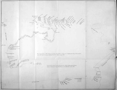
xcviiIt is worthy of remark, that the map by Klencke, already referred to, leaves the passage towards Torres Strait open, while in the map here given it is closed. The missing narrative of Tasman alone could explain this discrepancy, or show us the amount of authenticity to be ascribed to either of these maps; but it appears to the editor, that the track laid down with the soundings, gives to the map here given the claim to preference, while the very depth of the imaginary xcviiibight here drawn, instead of the strait, throws it out of the line of exploration in the voyage whose track is described. From the notes of the Burgomaster Witsen (1705), we derive the only fragment of an account of this most important voyage. From thence we gain the earliest information respecting the inhabitants. The translation is given by Dalrymple, in his volume on Papua. It is as follows: “In latitude 13 degrees, 8 minutes south, longitude 146 degrees, 18 minutes (probably about 129½ degrees east of Greenwich), the coast is barren. The people are bad and wicked, shooting at the Dutch with arrows, without provocation, when they were coming on shore. It is here very populous.”
“In 14 degrees, 58 minutes south, longitude 138 degrees, 59 minutes (about 125 degrees east) the people are savage, and go naked: none can understand them. In 16 degrees, 10 minutes south, the people swam on board of a Dutch ship, and when they received a present of a piece of linen, they laid it upon their head in token of gratitude. Every where thereabout all the people are malicious. They use arrows and bows, of such a length that one end rests on the ground when shooting. They have also hazegayes and kalawayes, and attacked the Dutch, but did not know the execution of the guns.
“In Hollandia Nova [a term which seems to imply that the previously named plans were not supposed by Witsen to be included under the name of New Holland] in 17 degrees, 12 minutes south (longitude 121 degrees or 122 degrees east), Tasman found xcixnaked black people, with curly hair: malicious and cruel, using for arms bows and arrows, hazeygayes and kalawayes. They once came to the number of fifty, double armed, dividing themselves into two parties, intending to have surprised the Dutch, who had landed twenty-five men; but the firing of the guns frightened them so much that they took to flight. Their canoes are made of the bark of trees: their coast is dangerous: there is but little vegetation: the people have no houses.”
“In 19 degrees, 35 minutes S., longitude 134 degrees (about 120 degrees apparently), the inhabitants are very numerous, and threw stones at the boats sent by the Dutch to the shore. They made fires and smoke all along the coast, which it was conjectured they did to give notice to their neighbours of strangers being upon the coast. They appear to live very poorly; go naked; eat yams and other roots.”
This fragment of description is meagre enough; but it is all that we can boast of possessing. It is further remarkable that those who have spoken of the part of the coast visited by Tasman in this voyage, have led their readers into a misconception by attributing the discovery of the Gulf of Carpentaria to Carpenter, and of the northern Van Diemen’s Land to the governor so named. So soon after the voyage as the year 1663, we find Thevenot printing as follows: “We shall, in due course, give the voyages of Carpenter and Diemen, to whom is due the principal honour of this discovery. Van Diemen brought back gold, porcelain, and a thousand other articles of cwealth; which at first gave rise to the notion that the country produced all these things: though it has been since ascertained that what he brought was recovered from a vessel which had been wrecked on these coasts. The mystery which the Dutch make of the matter, and the difficulties thrown in the way of publishing what is known about it, suggest the idea that the country is rich. But why should they shew such jealousy with respect to a country which produces nothing deserving so distant a journey?” La Neuville also, in his Histoire de Hollande (Paris, 1703, tom. ii, p. 213), speaking of Van Diemen, says: “This latter not only examined the coasts of this great land, but had two years previously sailed as far as 43 degrees towards the antarctic pole, and discovered, on the 24th of November 1642, a new country in the other continent, which now bears the name of Van Diemen’s Land.” Here the very details clearly expose the nature of the mistake, since the maps and the instructions to Tasman shew his second voyage to have been in 1644, and the discovery of Van Diemen’s Land in 1642 is known to be his beyond all dispute. The fact is moreover confirmed by the identity of the names given to the tracts discovered in these two voyages, viz. those of the principal members of the council and of Marie van Diemen, to whom Tasman is supposed to have been attached.
Prévost, in his Histoire des Voyages (Paris, 1753, tom. ii, p. 201), says that Carpentaria was discovered by Carpenter in 1662. We then find De Brosses correcting this statement (p. 433) by saying, “the ciAbbé Prevost ought not to have stated that, in 1662, Carpentaria was discovered by Pieter Carpenter, since he was Governor-General of the Company of the Indies, and returned to Europe in June 1628 with five vessels richly laden.” He then quotes the above passage from Thevenot, and continues: “Unfortunately Thevenot has not fulfilled his promise respecting Carpentaria. That learned collector was engaged in preparing, at the time of his decease, a fifth volume of his collection, of which some incomplete portions of what he had already published were found in his cabinet. From amongst these I have extracted the journal of Captain Tasman, who discovered Van Diemen’s Land. There was, however, nothing respecting the voyage of Captain Carpenter, nor that of the Governor-General, Van Diemen, even if he had left one: at least, if the manuscripts of these voyages were there originally, it is not known what has become of them.” De Brosses concludes by saying that his researches in private collections and in printed geographical works had been unsuccessful in procuring further information on the subject. Subsequent geographers continued to attribute to Carpenter the discovery of Carpentaria, and many of them to Van Diemen the discovery of the north Van Diemen’s Land. In Dubois’ work, Vies des Gouverneurs Généraux, already quoted, which was compiled in Holland from the manuscript journals and registers from Batavia, he says expressly, p. 82, in speaking of Carpenter, who was governor between 1623 and 1627: “Some writers attribute to him personally the honour ciiof the discovery of Carpentaria, the southern land lying between New Guinea and New Holland; but this is without any apparent foundation, inasmuch as they fix this discovery in the year 1628, in which year he returned to Holland, on the 12th of June, with five vessels richly laden, having sailed from Batavia on the 12th of November of the previous year.” It should, moreover, be observed, that no evidence has been adduced of his having been on the coast at all, while there is every reason to believe that the exploration of the Gulf of Carpentaria was not only “achevé,” as M. Eyriès suggests (p. 12, art. 1, vol. ii, of Nouvelles Annales des Voyages), by Tasman in 1644, but accomplished by that navigator for the first time. It might then be asked how comes it that Tasman, who had in both his voyages so largely complimented the governor Van Diemen, by giving his name and that of his daughter Maria, to whom he was attached, to various points of his discovery, should finally give the name of Carpenter to an important gulf and tract of country, when the governor bearing that name had left Batavia sixteen years before? The answer is readily given. The Governor and Company of Batavia formed a local administration under the presidency of the Company of the Indies at Amsterdam, which latter consisted of seventeen delegates from the seventeen provinces of the Netherlands. In the year 1623, in which Carpenter commenced his governorship in the east, an event occurred in Amboina which threatened to produce a war between Holland and England. Some English ciiiofficials, in concert with some Japanese soldiers, had formed a conspiracy to kill the Dutch in the island and to gain possession of the fortress. The conspiracy was discovered, and the governor had the conspirators put to death. In England the governor’s conduct was regarded as a piece of heartless cruelty. Mutual recriminations ensued, and for several years a contest between the two countries was imminent. After Carpenter’s return to Holland in 1628, he was sent out as one of a deputation to London on this subject despatched in the year 1629. He was also appointed president of the Company of the Indies in Amsterdam, which post he occupied till his death in 1659. It need, therefore, no longer be subject of surprise that Tasman should have given the name of Carpenter, the president of the Home Company of the Indies, to an extensive country and gulf discovered by him in 1644.
We cannot dismiss our notice of this important voyage, which thus gave the name of New Holland to the great South Land, without quoting the remark of Thevenot in the Relation de l’estat présent des Indes, prefixed to the second volume of his Relation de Divers Voyages Curieux. He says: “The Dutch pretend to have a right to the southern land which they have discovered.... They maintain that these coasts were never known by the Portuguese or the other nations of Europe.... It is to be noticed that all this extent of country falls within the line of demarcation of the Dutch East India Company, if we are to believe their maps, and that civthis motive of interest has perhaps made them give a false position to New Zealand, lest it should fall within the line of demarcation of the Dutch West India Company; for these two companies are as jealous of each other, as they are of the other nations of Europe.... It is to be observed, that although the Portuguese possess many places in the Indies, they are extremely weak, by reason that their enemies are masters of these seas and of the traffic which they themselves formerly possessed.”
The observation would seem to imply that Thevenot, a Frenchman, was not wanting in the belief that these coasts had really been discovered by the Portuguese before they were visited by the Dutch, while it passes by in silence any thought of a claim thereto on the part of his own countrymen, a point worth noticing in connexion with the evidence of the early French manuscript maps of which we have already so fully treated.
From the voyage of Tasman to the close of the seventeenth century, it is probable that a considerable number of voyages were made to the west coasts of New Holland, of which no account has ever been printed. By the obliging and intelligent assistance of Mr. Frederick Müller, of Amsterdam, (a rare example of a bookseller who interests himself not only in obtaining curious early books illustrative of the history of his country, but in minutely studying that history himself), the editor has been enabled to procure some documents from the Hague, which have never before been printed, and one which, although cvin print, has become exceedingly scarce, and has never before been rendered into English.
The earliest of these is an account of the ship De Vergulde Draeck, on the Southland, and the expedition undertaken both from Batavia and the Cape of Good Hope in search of the survivors, etc., drawn up and translated from authentic MS. copies of the logbooks in the Royal Archives at the Hague. De Vergulde Draeck, which set sail from the Texel in October 1655, was wrecked on a reef on the west coast, in latitude 30 degrees, 40 minutes, and a hundred and eighteen souls were lost. The news was brought to Batavia by one of the ship’s boats, sixty-eight of the survivors having remained behind, exerting themselves to get their boat afloat again, that they might send some more of their number to Batavia. The Governor General immediately dispatched the flyboat the Witte Vaclk, and the yacht the Goede Hoop, to the assistance of those men, and also to help in the rescue of the specie and merchandize lost in the Vergulde Draeck. This expedition was attended with bad success, as they reached the coast in the winter time. Similar ill luck attended the flyboat Vinck, which was directed to touch at New Holland, in its voyage from the Cape to Batavia in 1657, to search for the unfortunate men who had been left behind. The company next dispatched from Batavia two galliots, the Waeckende Boey, and the Emeloort, on the 1st of January, 1658. These vessels also returned to Batavia in April of the same year, having each of them separated, after parting company by the way, cvisailed backwards and forwards again and again, and landed parties at several points along the coast. They had also continually fired signal guns night and day, without, however, discovering either any Dutchmen, or the wreck of the vessel. The only things seen were some few planks and blocks, with a piece of the mast, a taffrail, fragments of barrels, and other objects scattered here and there along the coast, and supposed to be remnants of the wreck. This account, with a description of the west coast of the South Land, by the Captain Samuel Volkersen, of the Pink Waeckende Boey, is accompanied by copies of original charts, showing the coast visited by this vessel and the Emeloort, never before printed. These documents are followed by an extract from the Burgomaster Witsen’s Noord en Oost Tartarye, descriptive of the west coast, a portion of which is plainly derived from the account of Abraham Leeman, the mate of the Waeckende Boey.
We must not here omit to mention, that in the year 1693, appeared a work bearing the following title: Les Avantures de Jaques Sadeur dans la découverte et le voyage de la Terre Australe, contenant les coutumes et les mœurs des Australiens, leur religion, leurs exercises, leurs études, leurs guerres, leurs animaux, particuliers à ce pays et toutes les raretez curieuses qui s’y trouvent. À Paris, chez Claude Barbin, au Palais, sur le second perron de la Sainte Chapelle, 1693. In the Vannes edition, p. 3, the author’s Christian name is given Nicolas. An English translation appeared in the same year, entitled cvii“A new discovery of Terra Incognita Australis, or the Southern World, by James Sadeur, a Frenchman, who, being cast there by a shipwreck, lived thirty-five years in that country, and gives a particular description of the manners, customs, religion, laws, studies and wars of those southern people, and of some animals peculiar to that place, with several other rarities. These memoirs were thought so curious, that they were kept secret in the closet of a late great minister of state, and never published till now, since his death. Translated from the French copy printed at Paris by publick authority, April 8. Imprimatur, Charles Hern, London. Printed for John Dunton, at the Raven, in the Poultry, 1693.” The work is purely fictitious throughout.
The next Dutch voyage of which we have succeeded in finding an account, is that of Willem de Vlamingh, in 1696, which also owed its origin to the loss of a ship, the Ridderschap van Hollandt. This vessel had been missing from the time she had left the Cape of Good Hope in 1684 or 1685, and it was thought probable she might have been wrecked upon the great South Land, and that some of the crew might, even after this lapse of time, be still living. The commodore, Willem de Vlaming, who was going out to India with the Geelvink, Nyptang, and Wezel, was, therefore, ordered to make a search for them. The account of this voyage, which was printed at Amsterdam in 1701, 4to, is exceedingly scarce; and after many years enquiry, the editor cviiideemed himself fortunate in procuring it through the medium of Mr. Müller, of Amsterdam, and a translation of it is here given. The search of De Vlaming was, however, fruitless, and the two principal points of interest were the finding of the plate already described, with the inscription commemorating the arrival and departure of Dirk Hartog, in 1616, and the discovery of Swan River, where the embodiment of the poet’s notion of a rara avis in terris was for the first time encountered, and two of the black swans were taken alive to Batavia.
Meanwhile, the shores of New Holland had been visited by a countryman of our own, the celebrated Dampier. In the buccaneering expedition in which he made a voyage round the world, he came upon the north-west coast in 16 degrees, 50 minutes due south from a shoal, whose longitude is now known to be 122¼ degrees east. Running along the shore N.E. by E., twelve leagues to a bay or opening convenient for landing, a party was sent ashore to search for water, and surprised some of the natives, some of whom they tried to induce to help in filling the water casks, and conveying them to the boat. “But all the signs we could make,” says Dampier, “were to no purpose; for they stood like statues, staring at one another, and grinning like so many monkeys. These poor creatures seem not accustomed to carry burdens; and I believe one of our ship’s boys, of ten years old, would carry as much as one of their men.” In his description of the natives, he agrees with Tasman in their being “a naked black people, with cixcurly hair, like that of the negroes in Guinea; but he mentions other circumstances which are not mentioned in the note from Tasman.” He describes them as “the most miserable people in the world. The Hottentots compared with them are gentlemen. They have no houses, animals, or poultry; their persons are tall, straight bodied, thin, with long limbs; they have great heads, round foreheads, and great brows; their eyelids are always half closed, to keep the flies out of their eyes, for they are so troublesome here, that no fanning will keep them from one’s face; so that, from their infancy, they never open their eyes as other people do, and therefore they cannot see far, unless they hold up their heads as if they were looking at something over them. They have great bottle noses, full lips, wide mouths; the two fore teeth of the upper jaw are wanting in all of them; neither have they any beard. Their hair is short, black and curled, and their skins coal black, like that of the negroes in Guinea. Their only food is fish, and they consequently search for them at low water; and they make little weirs or dams with stones across little coves of the sea. At one time, our boat being among the islands, seeking for game, espied a drove of these people swimming from one island to another, for they have neither boats, canoes, nor bark logs.” Dampier remained there from January 5 to March 12, 1688, but is silent as to any dangers upon the twelve leagues of coast seen by him.
In the year 1699, Great Britain being at peace cxwith the other maritime states of Europe, king William ordered an expedition for the discovery of new countries, and for the examination of some of those already discovered, particularly New Holland and New Guinea. Dampier’s graphic narrative of his buccaneering voyages caused the Earl of Pembroke to select him to conduct the expedition. The Roebuck, a ship belonging to the royal navy, was equipped for the purpose. After a voyage of six months, Dampier struck soundings in the night of August 1st, 1699, upon the northern part of the Abrolhos shoal, in latitude about 27 degrees, 40 minutes S. Next morning he saw the main coast, and ran northward along it, discovering in 26 degrees, 10 minutes, an opening two leagues wide, but full of rocks and foul ground. August 6th, he anchored in Dirk Hartog’s Road, at the entrance of a sound which he named Shark’s Bay: where he remained eight days examining the sound, cutting wood upon the islands, fishing, etc., and gives a description of what was seen in his usual circumstantial manner. His description of the kangaroo, probably the first ever given of that singular animal, is a curious one. “The land animals we saw here were only a sort of raccoons, but different from those of the West Indies, chiefly as to their legs; for these have very short forelegs, but go jumping, and like the raccoons are very good meat.”
Sailing northward along the coast, he found an archipelago extending twenty leagues in length, which has been more recently examined by Captain cxiKing. He anchored in lat. 20 degrees, 21 minutes, under one of the largest of the islands, which he named Rosemary Island. This was near the southern part of De Witt’s Land; but besides an error in latitude of 40 minutes, he complains that in Tasman’s charts “the shore is laid down as all along joining in one body or continent, with some openings like rivers, and not like islands, as really they are.” “By what we saw of them, they must have been a range of islands, of about twenty leagues in length, stretching from E.N.E. to W.S.W., and, for aught I know, as far as to those of Shark’s Bay; and to a considerable breadth also, for we could see nine or ten leagues in amongst them, towards the continent or main land of New Holland, if there be any such thing hereabouts: and by the great tides I met with awhile afterwards more to the north-east, I had a strong suspicion that here might be a kind of archipelago of islands; and a passage, possibly, to the south of New Holland and New Guinea, into the great South Sea eastward.
“Not finding fresh water upon such of the islands as were visited that day, Captain Dampier quitted his anchorage next morning, and ‘steered away E.N.E., coasting along as the land lies.’ He seems to have kept the land in sight, in the daytime, at the distance of four to six leagues; but the shore being low, this was too far for him to be certain whether all was main land which he saw; and what might have been passed in the night was still more doubtful.
cxii“August 30th, being in latitude 18 degrees, 21 minutes, and the weather fair, Captain Dampier steered in for the shore; and anchored in eight fathoms, about three-and-a-half leagues off. The tide ran ‘very swift here; so that our nun-buoy would not bear above the water to be seen. It flows here, as on that part of New Holland I described formerly, about five fathoms.’
“He had hitherto seen no inhabitants; but now met with several. The place at which he had touched in the former voyage ‘was not above forty or fifty leagues to the north-east of this. And these were much the same blinking creatures (here being also abundance of the same kind of flesh flies teizing them), and with the same black skins, and hair frizzled, tall and thin, etc., as those were. But we had not the opportunity to see whether these, as the former, wanted two of their fore teeth.’ One of them, who was supposed to be a chief, ‘was painted with a circle of white paste or pigment about his eyes, and a white streak down his nose, from his forehead to the tip of it. And his breast, and some part of his arms, were also made white with the same paint.’
“Neither bows nor arrows were observed amongst these people: they used wooden lances, such as Dampier had before seen. He saw no houses at either place, and believed they had none; but there were several ‘things like haycocks, standing in the savannah; which, at a distance, we thought were houses, looking just like the Hottentots’ houses at the Cape cxiiiof Good Hope; but we found them to be so many rocks.’ These rocks he could not have examined very closely; for there can be little doubt that they were the anthills described by Pelsart as being ‘so large, that they might have been taken for the houses of Indians.’
“The land near the sea coast is described as equally sandy with the parts before visited, and producing, amongst its scanty vegetation, nothing for food. No stream of fresh water was seen, nor could any, fit to drink, be procured by digging.
“Quitting this inhospitable shore, Captain Dampier weighed his anchor on September 5th, with the intention of seeking water and refreshments further on to the north-eastward. The shoals obliged him to keep at a considerable distance from the land, and finally, when arrived at the latitude of 16 degrees, 9 minutes, to give up his project, and direct his course for Timor.”
With the voyage of Dampier terminates the information gained of the western coasts previously to the present century, which does not lie within the range of our inquiries.
In 1705 another and last voyage was made by the Dutch for the discovery of the north coast. The expedition consisted of three vessels, the Vossenbosch, the Wayer, and the Nova Hollandia. The commander was Martin van Delft. The journals appear to have been lost. At all events they have not hitherto been found, but a report to the Governor-General and cxivCouncil of the discoveries and notable occurrences in the expedition, was drawn from the written journals and verbal recitals of the officers on their return, by the Councillors Extraordinary, Hendrick Swaardecroon and Cornelis Chastelijn. This report is given for the first time in English in the present collection, from which it appears that the part of the coast visited was carefully explored, and that the Dutch had intercourse with the natives, a result in which De Vlaming’s expedition had entirely failed. In the miscellaneous tracts of Nicholas Struyck, printed at Amsterdam, 1753, is also given an imperfect account of this voyage as follows: “March 1st, 1705. Three Dutch vessels were sent from Timor with order to explore the north coast of New Holland, better than it had before been done. They carefully examined the coasts, sand banks, and reefs. In their route to it, they did not meet with any land, but only some rocks above water, in 11 degrees, 52 minutes south latitude” (probably, says Flinders, the south part of the great Sahul Bank, which, according to Captain Peter Heywood, who saw it in 1801, lies in 11 degrees 40 minutes). “They saw the west coast of New Holland, four degrees to the eastward of the east point of Timor. From thence they continued their route towards the north, and passed a point, off which lies a bank of sand above water, in length more than five German miles of fifteen to a degree. After which they made sail to the east, along the coast of New Holland; observing everything with care, until they came to a gulf, the head cxvof which they did not quite reach. I (Struyck) have seen a chart made of these parts.”
Flinders remarks upon this account, “What is here called the west must have been the north-west coast,” and he is right; for in the report here printed, the country is called “Van Diemen’s Land,” lying, as we know, on the north-west coast of New Holland, already in this introduction frequently referred to in distinction from the island more generally so known, and now called Tasmania. Flinders continues: “which the vessels appear to have made somewhat to the south of the western Cape Van Diemen. The point which they passed was probably this same cape itself; and in a chart, published by Mr. Dalrymple, August 27th, 1783, from a Dutch manuscript (possibly a copy of that which Struyck had seen), a shoal, of thirty geographic miles in length, is marked as running off from it, but incorrectly, according to Mr. M’Cluer. The gulf here mentioned was probably a deep bay in Arnhem’s Land; for had it been the Gulf of Carpentaria, some particular mention of the great change in the direction of the coast would, doubtless, have been made.”
In the year 1718 a Mons. Jean Pierre Purry, of Neufchatel, published a work entitled, Mémoire sur le Pays des Caffres et la Terre de Nuyts par rapport à l’utilité que la Compagnie des Indes Orientales en pourroit rétirer pour son Commerce, followed by a second memoir in the same year. These publications were explanatory of a project he entertained of founding a colony in the land of Nuyts. The scheme had cxvibeen submitted to the Governor-General, Van Swoll, at Batavia, but was discountenanced. It subsequently met the same fate when laid by its author before the Directors of the Dutch East India Company at Amsterdam. M. Purry shortly afterwards brought his proposition before the West India Company, and it was supposed by some that the voyage of Roggeween to the South Seas in 1721 was a result of this application; but it is distinctly stated by Valentyn that it was an entirely distinct expedition. In 1699 Roggeween’s father had submitted to the West India Company a detailed memoir on the discovery of the southern land; but the contentions between Holland and Spain prevented the departure of the fleet destined for the expedition, and it was forgotten. Roggeween, however, who had received his father’s dying injunctions to prosecute this enterprize, succeeded at length in gaining the countenance of the directors, and was himself appointed commander of the three ships which were fitted out by the company for the expedition. According to Valentyn, the principal object of this voyage was the search for certain “islands of gold,” supposed to lie in 56 degrees south latitude; but the professed purpose was distinctly avowed by Roggeween to be directed to the south lands. Although the expedition resulted in some useful discoveries, it did not touch the shores of New Holland.
The last document in the collection here printed is a translation from a little work published in Dutch, in 1857, by Mr. P. A. Leupe, Captain of Marines in cxviithe Dutch Navy, “The Houtman’s Abrolhos in 1727,” detailing the disasters of which those dangerous shoals had been the cause.
It will be seen that we have been unable to supply any descriptive account of discoveries on the eastern coast of Australia. That it was really discovered, and in all probability by the Portuguese, in the early part of the sixteenth century, we have already endeavoured to show. During more than two centuries from that period, it was probably never visited by any European. The honour of exploring that portion of the great island was reserved for the immortal Cook, who first saw that coast on April 19th, 1770, but a reference to such well known explorations certainly does not fall within the scope of antiquarian investigation. The like may be said of the first visit to Van Diemen’s Land, subsequent to Tasman’s discovery in 1642, which was made by Marion a hundred and thirty years later.
In conclusion, it would be inappropriate to omit the remark that it is to that most able and distinguished voyager, Matthew Flinders, to whose valuable work, A Voyage to Terra Australis, the editor has been greatly indebted for help in this introduction, that we have to give the credit for the compact and useful name which Australia now bears. In a note on page 111 of his introduction, he modestly says, “Had I permitted myself any innovation upon the original term [Terra Australis], it would have been to convert it into Australia, as being more agreeable to the ear, cxviiiand an assimilation to the names of the other great portions of the earth.”
It has been the habit, for the most part, of editors of works for the Hakluyt Society, to endeavour to elucidate their text by introductions, which have often reached to a considerable length. A very slight consideration of the nature of the subjects which the Society professes to deal with, will show the reasonableness, nay, even the necessity of such introductions. When the attention of a reader is invited to the narrative of a voyage, however interesting and curious in itself, which carries him back to a remote period, it is but reasonable that he should have explained to him the position which such a narrative, arbitrarily selected, holds in the history of the exploration of the country treated of. To do this satisfactorily is clearly a task requiring no little labour, and although it may necessarily involve a somewhat lengthy dissertation, certainly calls for no apology. Nevertheless, the simple fact of an introduction bearing a length at all approaching to that of the text itself, as is the case in the present volume, does, beyond question, at the first blush, justly require an explanation. All the publications of our Society consist of previously unpublished documents, or are reprints or translations of narratives of early voyages become exceedingly rare. But it is evidently matter of accident to what length the text may extend, while it is equally evident that the introductory cxixmatter illustrative of a small amount of text may be, of necessity, longer than that required to illustrate documents of greater extent. This is strikingly the case with the subject of the present volume. It has been matter of good fortune that the editor has been enabled to bring together even so many documents as are here produced, in connection with the early discoveries of Australia, while the enigmatical suggestions of early maps, unaccompanied by any descriptive matter to be found after diligent research, has necessitated an inquiry into their merits, which, though lengthy, it is hoped will not be deemed unnecessary. This so called introduction in fact, in a great measure, consists of matter, which, if supplied by original documents, would form a component part of the text itself.
The editor cannot close his labours on this most puzzling subject of the “Early Indications of Australia,” without expressing an earnest hope that further researches may yet result in the production of documents, as yet undiscovered, which may throw a light upon the history of the exploration of this interesting country in the sixteenth and seventeenth centuries, and, if possible, solve the great mystery which still hangs over the origin of the early manuscript maps so fully treated of, and it is hoped not without some advance towards elucidation, in this introduction.