ENGLAND (continued 2)
Reading edition
Helm Crag.—Colonel Barrow, speaking of this hill, observes that climbing among these rocks requires care. There are places quite as dangerous and as difficult as on any rock-work on the Alps. He was deterred from climbing the rock which is supposed to resemble a mortar, by a slab of rock slanting sideways, but in his opinion there was no great difficulty, except that arising from the absence of hold for hand and foot—an exception of some importance.
Helvellyn.—A mountain which belongs equally to Grasmere and to Patterdale, though the latter has by far the finest side of it. Striding Edge on this side was at one time considered to present terrors such as the hardy mountaineer was not likely to encounter elsewhere. This side is cut up into deep coves, which are exceedingly steep and afford many opportunities for scrambling, and near the path in Grisedale there is one of the numerous Eagle Crags.
On the west side there is no climbing on the mountain itself, but on the range of Dodds, which runs away to the north, there is capital work to be found; see Bram Crag and Wanthwaite Crags. It was in connection with Helvellyn that Colonel Barrow issued his famous challenge to the Alpine Club. After stating that he had ascended the mountain by every possible way of getting up it, and that it is the easiest of mountains to ascend from any direction that is possible, he continues: 'No one, I think, will venture the impossible, which may be found on all the highest mountains in the Lake District. They have their precipitous sides for adventurous climbers, who, I promise, will never get up them even if they have a mind to try—viz., these, Great Gable, Great End, Helvellyn, Fairfield, &c. Most of the difficult things in the Alps have been accomplished. Here is a new field for any of the adventurous climbers of our club: let them try these precipitous sides!' Helvellyn was long regarded as the loftiest of the Lake mountains, the height assigned to it by West being 3,324 ft., and even its tame grassy slopes towards Wythburn were thought very terrible indeed. In the 'Beauties of England' Thirlmere is described as 'a scene of desolation which is much heightened by the appearance of the immense craggy masses, that seem to hang on the sides of Helvellyn, from whose slopes they have apparently been severed, but arrested in their tremendous progress down the mountain by the impulse of gravitation. Huge and innumerable fragments of rocks hang pendant from its sides, and appear ready to fall and overwhelm the curious traveller who dares to ascend its wild and fantastic heights.'
Heron Crag, Eskdale.—A rock in Eskdale (q.v.) which was long reputed inaccessible. It was supposed to be 120 yards high, and to have a front like polished marble. It will be found north of the Esk river, not far from Throstlegarth (Cumberland, sheet 79).
High Level.—This name was bestowed about the year 1880 on a particular route, by means of which the north-east foot of the Pillar Rock may be reached from Black Sail along the face of the mountain, thus avoiding the descent into Ennerdale and the subsequent laborious ascent to the rock. The saving in time is very considerable, but the way is so easily missed in thick weather that a stranger who attempted it would probably gain nothing but an exciting walk.
After reaching the slight hollow between Lookingstead and Pillar Fell, Green Cove is seen below. Here a descent may be made at once, but it is better to proceed westward till about two dozen uprights of the iron railing are passed, and then to descend, keeping as much to the left as the cliffs will allow. The whole art of choosing a line along this face is to cross each successive cove as high up as may be done without getting impeded by rocky ground. The ridges which separate the coves mostly form small headlands, and just above each headland a strip of smooth grass crosses the ridge. Economy in time is usually of more importance at the end than at the beginning of a day, and it is well to know that, whereas from the foot of the rock to Black Sail by way of the valley would take up the greater part of an hour, Mr. Hastings and the writer once timed themselves on the High Level, and found that they reached Lookingstead in 18 minutes and the ford in Mosedale in seven minutes more.
High Stile, in Cumberland, between Ennerdale and Buttermere, has a height of 2,643 ft., and on its north-west side a few good crags. It is best reached by following up the course of Sour Milk Gill from the foot of Buttermere to Bleaberry Tarn, which can be reached from any of the inns in an hour's walking. In a note made in the Wastdale Head book in August 1887, Mr. Robinson called attention to these rocks, and he it is who has done most of the exploration here.
The principal climbing is in and about a gully in the centre. A course may be taken up very steep grassy binks with the gully on the right hand. The gully itself was climbed direct in September 1893 by Messrs. Jones, Robinson and Wilson, and they found the second pitch very difficult. The same party also ascended 'a short, black-looking chimney away round on the left of the great crag, and nearer the top of the mountain.' The very hard upper pitch was passed on the right hand, and the final pull was by the arms alone. Both climbs are in full view from Rigg's Buttermere Hotel.
The mountain is called High Steel in some early maps, and in that of the Ordnance it comes on sheet 69.
High Street, with the Roman road running all along its ridge, lies between Patterdale and Mardale Green, in Westmorland. It has a fine precipitous side towards the latter place at Blea Water (see Dixon's Three Jumps), and at the south end of it, about Gavel Crag and Bleathwaite Crag, there are some good rocky faces, which can be readily found by following up the course of the beck from Kentmere.
Hobcarton Crags have a considerable repute, which they have only retained by reason of their not being very easily got at. The simplest way of reaching them from Keswick is to take the train to Braithwaite, then go up the straight Coledale until Force Crag is passed, then trace the stream which comes down the hill on the right. Hobcarton is just over the ridge, and the crags are on the left-hand side of the valley. A descent may be made of a ridge which forms the right bank of a gill, which runs from near the col where you are now standing; the gill itself is too rotten.
The Crags are very steep and very rotten; but there is one curiosity about them, in the shape of a continuous sloping ledge, growing very narrow indeed towards the top. It rises gradually in the direction of Hopegillhead. The crags are picturesque, but can be traversed in any direction without difficulty, and present no definite climb. Another way of reaching them from Keswick is by crossing Whinlatter Pass, and on the far side turning up the first valley to the left hand.
Honister, one of the grandest crags in Cumberland, is reached from either Buttermere or Borrowdale. It is one of the chief attractions of the 'Buttermere Round' made by the breaks from Keswick. If quarrymen could only have been persuaded to let it alone, it would have been a delightful climbing ground; as things are, we can only look and long. Apart from the great crag there is a fine view of the lakes below from the summit (called Fleetwith Pike). Owing to its position near the black-lead mines, this was one of the earliest Lake mountains of which we have a recorded ascent. It was made before the middle of last century, and, so far as can be made out, these early mountaineers ascended from Seathwaite and passed to the northward of Grey Knotts, and so to the top of Fleetwith. 'The precipices were surprisingly variegated with apices, prominencies, spouting jets of water, cataracts and rivers that were precipitated from the cliffs with an alarming noise' [Sourmilkgill]. On reaching the apparent top, they were astonished to perceive a large plain to the west, and from thence another craggy ascent, which they reckoned at 500 yards. 'The whole mountain is called Unnisterre or, as I suppose, Finisterre, for such it appears to be.' In about another hour two of the party gained this summit—'the scene was terrifying—the horrid projection of vast promontories, the vicinity of the clouds, the thunder of the explosions in the slate quarries, the dreadful solitude, the distance of the plain below, and the mountains heaped on mountains that were lying around us desolate and waste, like the ruins of a world which we only had survived excited such ideas of horror as are not to be expressed. We turned from this fearful prospect, afraid even of ourselves, and bidding an everlasting farewell to so perilous an elevation. We descended to our companions, repassed the mines, got to Seathwayte, were cheerfully regaled by an honest farmer in his puris naturalibus, and returned to Keswic about nine at night.'
Hope (-hop, -up): used by Leland as equivalent to 'brook,' but usually taken to mean a retired upland valley. The Icelandic 'hop' is applied to landlocked bays.
Hough—a hill name in east Yorkshire. Phillips says that it is equivalent to 'barf,' and means 'a detached hill.' It is pronounced 'hauf.' If this be the exact sense, it can hardly be the same word as 'heugh,' which is used further north for 'crag' or 'precipice,' and it is perhaps merely another form of 'how' or 'haugh.'
How (-oe, -ah, -a, -haw): a Norse word for a burial mound, found all over the North of England.
Ice-axe.—On the high Fells in time of snow an axe is a safeguard of vital importance. Quite apart, too, from the comfort and security which it alone can give, it is an implement which can only be properly manipulated after long practice, and consequently a beginner should eagerly avail himself of every opportunity of acquiring dexterity in the use of it. From Christmas to Easter there is nearly always snow enough on the fells of Cumberland to give excellent practice in step-cutting.
Ill Bell.—A Westmorland hill forming a series of three with Froswick and Rainsborrow Crag. Its north or north-easterly face is very steep for a height of about 300 ft. Staveley is perhaps the best starting-point for these three; but they can be managed quite easily from Ambleside or Mardale Green. Ill Bell is on sheet 20 of the Ordnance map of Westmorland.
Ingleborough, 2,361 ft., one of the most striking of the Yorkshire mountains, of which the poet Gray spoke as 'that huge creature of God.' Readers of the 'Heart of Midlothian' will remember how it reminded Jeannie Deans of her 'ain countrie.' The most exaggerated ideas of its height formerly prevailed. Even in 1770 it was commonly reckoned at 3,987 ft., and Hurtley actually gives 5,280 ft.
Its top is only about four miles from Clapham, and ponies can go all the way. It is ascended far and away more frequently than any other Yorkshire hill, and consists mainly of limestone cliffs and slopes of shale, with a certain amount of millstone grit.
Here are some very remarkable caves (see Alum Pot and Gaping Gill Hole), and of some of these there is an early description by Mr. Adam Walker in the Evening General Post for September 25, 1779, which is quoted by West, and an account of an ascent of it made in the year 1761 is also extant.
Jack's Rake is a natural passage across the face of Pavey Ark in Langdale. The first notice ever taken of it by any but shepherds was a note in the visitors' book belonging to the inn at Dungeon Gill by Mr. R. Pendlebury, who spoke highly of it, considering it to be a striking yet simple excursion among magnificent rock scenery. After a time the world came to look at Pavey Ark, and seeing an impossible-looking combination of ravine and precipice, concluded, not unnaturally, that it must be what Mr. Pendlebury had found a pleasant yet simple stroll. Under this delusion, they began to try to climb what is now known as the Great Gully in Pavey Ark, and did not expect to find a place anything like the real Jack's Rake.
Mr. Gwynne, in 1892, says of it: 'Along the face of the cliff there runs a ledge that looks from below hardly wide enough for a cat to stand upon. However, if an attempt is made to climb it, it will be found wide enough for two fat men walking abreast. Towards the top it tapers off again, and the climber will have to do a bit of scrambling to get on to the summit of the precipice. This is a climb which offers no difficulty whatever, unless the climber is given to attacks of giddiness, and if that is the case there will hardly be any need to tell him that he has no business there at all. This ledge, however, offers a multitude of good opportunities to the climber. It runs obliquely across the face of the precipice, but it need not necessarily be followed throughout its length by the mountaineer who wishes for something a little more exciting.
'About halfway up there runs on to the ledge a chimney which, when it is not a small waterfall, forms a pleasant climb to some broken rock above, whence the summit is easily reached. If, however, the water in the chimney makes it uncomfortable and unpleasant for the climber, he may still arrive at the top of it by choosing a long bit of steep smooth rock to the left. There are two cliffs which afford fairly good hand and foot holds, and from there the top of the chimney is attained.'
It is remarkable that a gallery more or less resembling this is found on many of the chief precipices in the Lakes. There is a steeper one on the Ennerdale Crags of Great Gable; there are two on the Ennerdale face of the Pillar Rock, and on Scafell the Rake's Progress and Lord's Rake in their mutual relation closely resemble this rake and the wide gully at the north end of it.
ToList
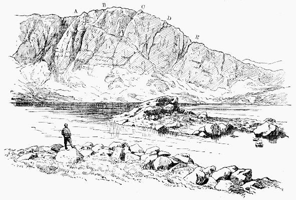
PAVEY ARK AND STICKLE TARN A, Narrow gully; B, Big gully; C, D, Smaller gullies; E, Wide scree gully. From the foot of E to A runs Jack's Rake.
Kern Knotts are on the south side of Gable, close to the Sty Head. There is a short but difficult gully here on the side facing Wastdale, which was climbed by Messrs. Owen Jones and Robinson in 1893, but described by them under the name of Tom Blue, a rock much higher up the mountain.
Keswick.—Though rather too distant from the very best climbing, this is an excellent centre in point of variety.
Of Skiddaw and Saddleback it enjoys a monopoly, while Helvellyn, Gable and Scafell Pikes are all within the compass of a day's work. The railway is a convenience, of course, but not as useful as one might expect in extending the field of operations, because most of the places to which it goes are of little interest. The town is very well supplied with driving facilities, such as coaches, breaks and omnibuses.
The clay-slate of which the Skiddaw and Grassmoor groups are composed provides climbing of smaller quantity and inferior quality to that found among the harder rocks of what is called the 'Borrowdale Series,' but there are a few good scrambles west of Derwentwater, such as Eel (or Ill) Crag, Force Crag, and Hobcarton. The nearest good rocks are in the neighbourhood of Wallow Crag, but there is no pleasure in climbing with a crowd of gaping excursionists below. A much pleasanter day may be spent in a visit to Wanthwaite. Of Keswick itself an early writer says that the poorer inhabitants subsist chiefly by stealing or clandestinely buying of those who steal the black-lead, which they sell to Jews and other hawkers; but whatever changes the character of the people has or has not undergone, it is not easy to believe that the scenery is the same as that which the early writers describe.
Camden's tone is neutral: 'Compassed about with deawy hilles and fensed on the North side with that high mountaine Skiddaw lieth Keswike;' but two centuries later, when the place began to be fashionable, this description would not have satisfied any one. The great characteristic of the scenery was considered to be its power of inspiring terror. Dr. Brown in his famous 'Letter' dwells upon the 'rocks and cliffs of stupendous height hanging broken over the lake in horrible grandeur, some of them a thousand feet high, the woods climbing up their steep and shaggy sides, where mortal foot never yet approached. On these dreadful heights the eagles build their nests, ... while on all sides of this immense amphitheatre the lofty mountains rise round, piercing the clouds in shapes as spiry and fantastic as the very rocks of Dovedale.... The full perfection of Keswick consists of three circumstances, beauty, horror and immensity united.'
Kirkfell has two fine buttresses of rock at the back, facing Ennerdale, but they are broken up and so only fit for practice climbs. They are, however, not unfrequently assailed by climbers who imagine themselves to be scaling the crags of Great Gable. The direct ascent from Wastdale is one of the steepest lengths of grass slope to be found among these hills. The only gully on this fell is Illgill, which faces Lingmell and contains two or three severe pitches. It is rather seldom visited, and is exposed to falling stones.
Lancashire.—Though some of the rough country which borders on Yorkshire contains a rocky bit here and there, Lancashire climbing has no real interest except in that part of it which belongs to the Lake country. The climax of this part is reached in the neighbourhood of Coniston. South of the Lakes there are some limestone crags of striking form. The impression produced on Defoe by what we consider the exceptionally beautiful scenery of the Lune valley is curious. 'This part of the country seemed very strange and dismal to us (nothing but mountains in view and stone walls for hedges; sour oatcakes for bread, or clapat-bread as it is called). As these hills were lofty, so they had an aspect of terror. Here were no rich pleasant valleys between them as among the Alps; no lead mines and veins of rich ore as in the Peak; no coal-pits as in the hills about Halifax, but all barren and wild and of no use either to man or beast.'
Langdale.—(See Bowfell, Pavey Ark and Pike o'Stickle, Gimmer Crag, Harrison Stickle, Oak How.) By many thought the finest valley in Westmorland; the name is often written Langden or Langdon by old authorities.
Dungeon Gill has always been a favourite haunt of climbing folk, and from this base strong walkers can easily manage to reach Scafell, Gable, Coniston, Old Man, or Helvellyn in the day.
Limestone is abundant in Derbyshire and Yorkshire, and forms the fine cliffs of Cheddar in Somerset, Berry Head in Devon, Anstis Cove and others; indeed most of the south coast of Devon and Cornwall east of Penzance is of this material. Chudleigh Rock and Morwell Rocks on the river Tamar are very striking. West, speaking of this rock in Lancashire, says, 'The whiteness and neatness of these rocks take off every idea of horror that might be suggested by their bulk or form.' In England it is very rare to find limestone which is a satisfactory material on which to climb.
Lingmell, called Lingmoor by Wilkinson, is a mere shoulder of Scafell Pike. It has, however, some fine cliffs facing those of Great Napes on Gable; between these two Housman thought a collision imminent. These used to be thought inaccessible, but were climbed by Mr. Bowring about 1880. There is a striking view of them from near Sty Head. The eye looks right along the dark ravine of Piers Gill, which is apparently overhung by the long line of these crags, rising from tongues of rock divided by huge fan-shaped banks of scree. There is a good deal of chance about the climbing here. It may be exciting, or you may just happen to avoid what difficulties there are. It is a very treacherous rock, especially low down, where curious long stone pegs are lightly stuck in the ground and come away at the first touch. A few feet below the top stands a curious pinnacle of forbidding appearance, of which a sensational photograph has been taken; but Mr. Robinson found one side from which the top is reached with ridiculous ease. Further west there are gullies facing Kirkfell which are worth climbing, though there is much unsound rock. (See also Piers Gill.)
ToList
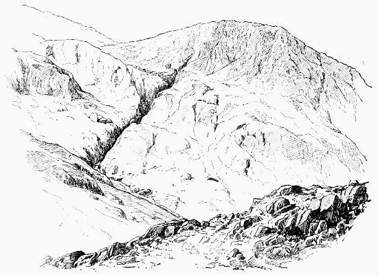
LINGMELL AND PIERS GILL
Lingmoor, rather over a mile south-east of Millbeck Inn, and near Oak How, is a little pinnacle of which a photograph and a description by Mr. H.A. Gwynne will be found in the Climbers' book at that place. In old maps the name is sometimes found applied to Lingmell.
Lord's Rake.—A well-known scree-shoot in the north face of Scafell, for the ascent of which from Mickledoor it offers an easy route without climbing. The earliest account of its being used for this purpose is in the Penny Magazine for 1837 at p. 293: 'It is very laborious and looks dangerous, but in fact there is no risk except that of a sprained ankle. It is through the Lord's Rake, a shaft between two vertical walls of rock about five yards across all the way up, and twenty or twenty-five minutes' hard climbing on all fours up a slope of about 45°. The place must have been cut out by a watercourse, but is now dry and covered with light shingle. It looks right down into Hollow Stones (the deep vale between the Pikes and Scafell), and most fearful it does look, but it is not dangerous. When we reached the inn at Eskdale over Scafell my shepherd was very proud of having brought me through the Lord's Rake, and the people were much surprised. It seems to be rather a feat in the country. It is the strangest place I ever saw. It may be recommended to all who can bear hard labour and enjoy the appearance of danger without the reality.' 'Prior's Guide' contained the first good description of this rake.
ToList
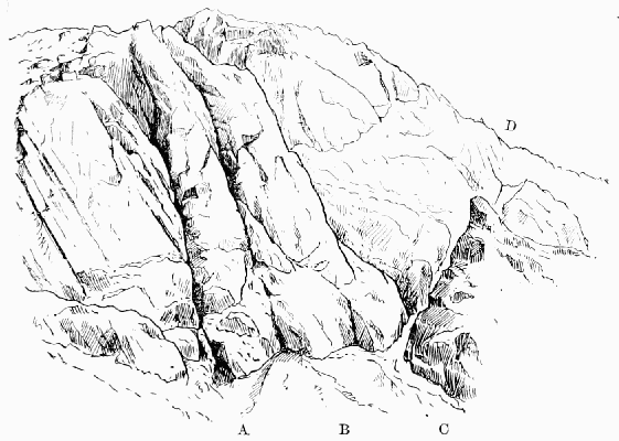
LORD'S RAKE AND RAKE'S PROGRESS A, The foot of Moss Gill; B, The foot of Steep Gill; C-D, Lord's Rake; C-A, Part of Rake's Progress.
Luxulion, in Cornwall, is of interest to the mineralogist and the travelled mountaineer on account of its enormous block.
According to Mr. Baddeley, this is the largest block in Europe, larger than any of the famous boulders at the head of the Italian lakes, and it may take rank with the largest known, the Agassiz blocks in the Tijuca mountains near Rio Janeiro. He gives the dimensions as 49 feet by 27 feet with 72 feet girth, yet makes no allusion to the Bowder Stone in Borrowdale, which in another work he describes as being 60 feet long, 30 feet high, and weighing 1,900 tons. It would appear, therefore, that the Bowder Stone is considerably larger than the largest stone in Europe without being so remarkable for size as another stone in England.
Malham Cove.—A fine example of the limestone scenery of the Craven Fault. The river Aire gushes forth from the base of the cove, which can easily be seen in the same excursion as Gordale Scar. The nearest town is Skipton-in-Craven and the nearest station Bell Busk, but Settle is very little farther and will generally be found the most convenient starting-point.
Mardale Green, at the head of Hawes Water, is a delightful and little visited spot. In the way of climbing it commands High Street, Harter Fell, Froswick, Ill Bell, and Rainsborrow Crag. The best near climbs are about Bleawater and Riggindale.
Mellbreak.—One of the few Cumberland fells which the indefatigable Colonel Barrow seems to have left unvisited; yet no one who stops at Scale Hill or Buttermere will consider wasted a day spent upon it. The proper course is to begin at the end which faces Loweswater village and ascend by Frier's Gill, a nice little climb. Having reached the top of the gill and then the summit plateau, proceed to the hollow about the middle of the mountain, and from there descend the highly curious Pillar Rake, which gradually slopes down towards the foot of Crummock Water. It is not a climb, but any one who is not content with the study of mountain form can find climbing in the little gullies which ascend the rocks above the rake. Sheet 63 of the Ordnance map of Cumberland contains it.
Mickledoor Chimney, in the cliffs of Scafell, is not the easiest, but the most obvious point at which to attack them. It is conspicuous from the Pikes, and would probably be selected by any experienced stranger as the most vulnerable point. It was visited about the year 1869 by Mr. C.W. Dymond, who contributed to 'Prior's Guide' the earliest and best description of it. He says that, 'leaving Mickledoor Ridge, you pass the fissure leading to Broad Stand, and continue descending steeply for two minutes, which brings you to a narrow gully in the rock, with a thread of water trickling down it over moss. This is the cheminée to be ascended, and there is no special difficulty in it until you are near the top. Here the gully, of which the 'chimney' forms the lower section, is effectually blocked for some distance, and the only alternative is to climb out of it by the rock which forms the right wall, and which is about 12 ft. high, the lower six vertical and the upper a steep slant. This, which can only be scaled à la chimney-sweep, is exceedingly difficult, as is also the gymnastic feat of escaping to terra firma from the narrow shelf on which the shoulder-and-hip work lands you.' This is very clear and in the main correct, but there is another and easier exit much lower down called 'the Corner,' and there is a third exit only a few feet from the mouth of the chimney. All these are on the right hand, for the opposite bank is not only much higher and much smoother, but would lead to nothing if it were surmounted. It is not really necessary to enter the chimney at all, for the edge presented where the bank cuts the wall bounding the screes is quite assailable, and just right of it there is a point which may even be called easy; but two terrible accidents which have occurred at this spot prove the necessity of care.
Until the extraordinarily dry season of 1893 the moss-grown block at the very head of the chimney had never been climbed. It was accomplished on the 12th of September by Mr. W.H. Fowler. By standing on the shoulders of a tall man he was able to reach a slight hold and to establish himself on a rough rectangular block forming the floor of a recess big enough to hold one man. The block above it was holdless, and overhanging and loose stones were a great nuisance.
Micklefell.—The highest mountain in Yorkshire, but except on that account it possesses no special attraction. The best starting-point is the High Force Inn in Teesdale, 5 miles from Middleton. By making the round of the mountain from High Force to Appleby some very fine rock-scenery may be enjoyed.
Millstone grit.—A material which is very abundant in Yorkshire and Derbyshire. It is fairly firm, but seldom affords a climb of any sustained interest. Few kinds of rock weather into such eccentric forms, and of this propensity Brimham Rocks are a good example. It forms most of the 'Edges' in Derbyshire, and generally speaking a precipice at the top of a hill is of this material, while those at the foot are of limestone.
Moses' Sledgate is a curious track, which has evidently been engineered with considerable care, running from near Seatoller in Borrowdale at the back of Brandreth, round the head of Ennerdale below Green and Great Gable, and then over Beck Head and down Gavel Neese into Wastdale. The question is, who made it and for what purpose was it used? A few years ago, the writer, while climbing with two friends among the crags on the Ennerdale side of Great Gable, stumbled quite by chance on something which seemed to throw a side-light on the question. This was a ruined hut thickly overgrown with moss, and showing no trace of any wood having been employed in its construction. The spot had evidently been chosen primarily with a view to concealment, and the result of enquiries kindly made since then by one of my friends has been to elicit proof of certain traditions still lingering among the older inhabitants of these dales concerning a noted distiller of illicit spirits, who flourished and defied the law among these wild retreats. At the same time it is not easy to believe that a smuggler would have undertaken the construction of such a path as this. In the South of England, it is true that the smugglers were considerable roadmakers; but that was at a time when smuggling was a great and well-organised institution, and it seems much more probable in this case that Moses made use of an old path constructed for some purpose which had at that time been abandoned.
The terms 'Moses' Path' and 'Moses' Trod' are also used to describe this track. It is not noticed in the guide-books, but something is said about it by Mrs. Lynn Linton.
Moss Gill, on Scafell, is the next gully on the east or Mickledoor side of Steep Gill. The name Sweep Gill ('from the probable profession of the future first climber of its extraordinary vertical chimneys') was suggested for it by Mr. Gilson shortly after its discovery, but that name has been entirely superseded. The first mention of it in the Wastdale Head book is a note by the present writer in June 1889, recommending it to any one in search of a new and difficult climb. His party on that occasion was repulsed after reaching the great blocks, which have only been passed since by the aid of the artificial step subsequently cut in the rock. It was tried again a fortnight later by a party under Mr. R.C. Gilson, which got very nearly, but not quite as far. Two days later the same party explored the gill from above and descended in it for a considerable distance. It was not, however, till three and a half years later, at Christmas, 1892, that the climb was accomplished by Dr. J.N. Collie, G. Hastings, and J.W. Robinson, and their account of it is:
ToList
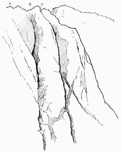
MOSS GILL AND STEEP GILL A, Moss Gill (Collie's exit); B, Moss Gill (Collier's exit): C, Top of Steep Gill. Just below the point to which A and B converge is the artificial step.
'The chief points in this climb are, First—to begin on the rock wall to the right of the foot of the gill and not in the very foot of the chimney itself, then enter the gill just below the first great pitch, which may be turned by climbing the wall on the right hand on to a grass ledge of considerable size, called the "Tennis Court"; enter the gill from here again, and pass into the cavern under the great boulder.'
'We found,' says Dr. Collie, 'that below the great slab which formed the roof, another smaller one was jammed in the gully, which, stretching across from side to side, formed the top of a great doorway. Under this we passed and clambered up on to the top of it. Over our heads the great rock roof stretched some distance over the gill. Our only chance was to traverse straight out along the side of the gill, till one was no longer overshadowed by the roof above, and then, if possible, climb up the face of rock and traverse back again above the obstacle into the gill once more. This was easier to plan than to carry out; absolutely no hand-hold, and only one little projecting ledge jutting out about a quarter of an inch and about two inches long to stand on, and six or eight feet of the rock wall to be traversed. I was asked to try it. Accordingly, with great deliberation, I stretched out my foot and placed the edge of my toe on the ledge. Just as I was going to put my weight on to it, off slipped my toe, and if Hastings had not quickly jerked me back, I should instantly have been dangling on the end of the rope. But we were determined not to be beaten. Hastings' ice-axe was next brought into requisition, and what followed I have no doubt will be severely criticised by more orthodox mountaineers than ourselves. As it was my suggestion I must take the blame. Peccavi! I hacked a step in the rock—and it was very hard work. But I should not advise any one to try and do the same thing with an ordinary axe. Hastings' axe is an extraordinary one, and was none the worse for the experiment. I then stepped across the mauvais pas, clambered up the rock till I had reached a spot where a capital hitch could be got over a jutting piece of rock, and the rest of the party followed. We then climbed out of the gill on the left, up some interesting slabs of rock. A few days later the gill was again ascended by a party led by Mr. J. Collier. They did not follow our track to the left after the overhanging rock had been passed, but climbed straight up, using a crack which looks impossible from down below, thus adding an extra piece of splendid climbing to the expedition.'
Only four days after Dr. Collie, a party of five climbers, led by Dr. J. Collier, made the second ascent of Moss Gill. The description given by their precursors was of great assistance, and except that the gill was entered much lower, the same line was followed up to the traverse from the great boulder. Here, instead of climbing out to the sky line on the left side, the ascent of the gill itself was completed by climbing the vertical moss-grown wall on the right. This part was entirely new, and Dr. Collier's note of his variation, or we may say correction, for his climb is the more direct of the two, is that the ascent of the wall was made by using the cleft of the gill for about 15 ft., when a resting place was reached. Above this point they climbed about 15 ft., and then traversed out on the face of the wall for about 8 ft. by some ledges which afforded just sufficient hold. They then ascended vertically about 6 or 8 ft., re-entering the cleft above a small platform of jammed stones ('Sentry Box'). This gave a starting-point for the completion of the ascent, which was made by climbing out on to the face of the wall to enable the jammed stones at the top of the pitch to be turned. These last stones did not appear to be secure and were avoided. From this point the gill continues upward at an easy slope, with one pitch of about 15 ft. to the back of the small summit on the left of Deep Gill. Two days later the ascent was repeated by Dr. Collier in company with Professor H.B. Dixon and the late Professor A.M. Marshall, the latter of whom inserted in the Climbers' book a remarkably bold and effective outline sketch of the gill, with explanatory notes. Speaking of the climb, he said that Mr. Collier led throughout, and that the success of the climb was due entirely to him. The climb is a very fine one, and, except for the leader, is entirely free from danger. At the very awkward return from Tennis Court Ledge into the gully, the leader can by a short traverse fix himself directly above the rest of the party. During the traverse from the 'window' the leader can fix the rope over the 'belaying-pin.' In the great chimney the Sentry Box is a place of absolute safety. The climb is difficult, but no part of the chimney is harder than the short rock face leading up to Tennis Court Ledge, and the most awkward traverse (if covered with snow) is the one from Tennis Court Ledge back into the gully. For a party of three 80 ft. of rope would be enough; 100 ft. perhaps better. On January 9, 1893, Mr. O.G. Jones attacked this formidable climb entirely by himself, following Mr. Collier's route up to the foot of the Great Chimney, and then Mr. Hastings' exit to the left. Heavy snow had fallen since the previous ascents and the climb appeared to be exceedingly difficult. Almost every hold had to be cleared of snow; essential precautions rendered the climb of five hours' duration, and it was not completed till after dark (5.45 p.m.). While clearing snow from the more remote portions of the Collie traverse from the window, in search of the third step, the difficulty of balancing proved too great, and he fell into the gully below. A rope had been secured round the window and thus prevented his passing beyond the snow patch on which he fell. The window 'sill,' already loose, was on the verge of falling, and was therefore pushed over into the gully. Returning two days later, he found that the two lowest chimneys in the gill could be taken straight up, and that the simplest way of reaching Tennis Court Ledge is by 'backing up' the chimney till the level of the recess in the right-hand face is reached. 'The recess is near enough to be taken with a stride. It would seem that the Tennis Court Ledge and traverse back into the gully may be entirely dispensed with by continuing up the chimney, the small jammed stones being firm enough to render the necessary assistance. While making these suggestions concerning small details in the climb, it may be mentioned that at the Collie traverse, which the writer's experience leads him to think is the most dangerous piece in the gill, an axe may be of much help to a party. A man fixed on the window sill may press the point of the axe into a conveniently placed notch in the slab facing him, so that the lower end of the handle shall supply a firm hand-hold for any one stretching round the third step.
Heights calculated by Mr. Jones.
Foot of Gill on Rake's Progress 2,625 ft.
Snow Patch below Tennis Court Ledge 2,805 "
Tennis Court Ledge 2,840 "
Foot of jammed stone pitch 2,870 "
Window in jammed stones 2,895 "
Snow patch above 2,920 "
Top of left-hand exit 3,140 "
Top of Moss Gill proper 3,170 "
It must, however, be borne in mind that these measurements, though useful for the purposes of comparison, cannot be absolutely correct, seeing that Scafell itself is only 3,162 ft. high. On February 11 Messrs. Slingsby, Woolley, and R. Williams found the gully very difficult owing to ice, and recorded an emphatic protest against any one following their example by attempting it, 'except when the rocks are dry and quite free from ice.'
On the last day of March Messrs. Brunskill and Gibbs followed, with a slight improvement, Dr. Collier's route, and made the subjoined observations, taken apparently with greater care than those by Mr. Jones:
Foot of Gill at Rake's Progress 2,570 ft.
Snow Patch above jammed stones 2,865 "
Top of Great Chimney or Moss wall 2,965 "
Top of Gill (neck leading to Deep Gill Pisgah) 3,065 "
It will be seen that while the points are all made lower than Mr. Jones's table, the height between the commencement of the climb and the snow patch above the jammed stones is exactly the same—295 ft. In this case an observation was taken at the cairn on the top of Scafell, and the aneroid stood at almost exactly the correct figure, which somewhat confirms the figures now given.
Napes.—A collection of fine rocks, starting up like a stack of organ pipes on the south side of Great Gable. The extremity of them nearest to Kirkfell is called White Napes, and sometimes Gable Horn. East of this is a gap known as Little Hell Gate. East of this comes Great Napes, and east of them again is Great Hell Gate, which is called Deep Gill in the Ordnance map.
In September, 1884, a note by the present writer in the book at Wastdale Head drew attention to these excellent rocks. They are now one of the most favourite climbs in Wastdale, and contain the well-known Needle, the Bear Rock, and the Arrowhead, with their respective gullies and arêtes.
Just west of Hell Gate there is a considerable width of very large and steep rock, which continues nearly to the Needle Ridge, with only a few steep and shallow gullies, in which the grass is very rotten. West of this ridge there is a deep gully, grassy, but exceedingly steep. The ridge beyond this was ascended in April, 1892, by Messrs. Slingsby, Baker, Solly, and Brigg, who called it the Eagle's Nest (q.v.). The narrow gully west of this ridge is apparently that which was climbed on December 29, 1890, by Mr. R.C. Gilson. He describes it as 'the gully on the left as you face the mountain of the gully coming down left of the Needle.' He proceeds to say that it presented no special difficulty, except at a point about one-third of the way up, where there was a large boulder and a smooth slab thinly glazed with ice. It was claimed as a first ascent when climbed on April 17, 1892, by Messrs. Solly and Schintz. West again of this is the ridge of the Arrowhead (q.v.). We are here getting near the end of Great Napes, which are separated on the west from White Napes by the scree gully which is called Little Hell Gate.
Napes Needle.—A rock of very striking form, which, by an eminent mountaineer, has been compared to a violon-cello.
It stands at the foot of the Needle Ridge in the Napes, and was first climbed by the writer about the end of June, 1886. The second ascent was made on March 17, 1889, by Mr. G. Hastings, and the third by Mr. F. Wellford on June 22, Mr. J.W. Robinson following on August 12 in the same year.
ToList
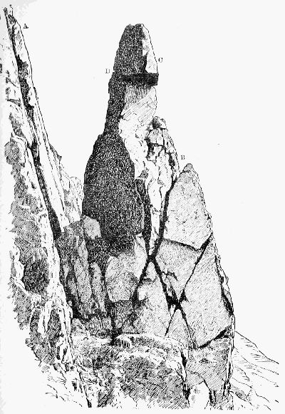
NAPES NEEDLE FROM THE WEST A, Needle Ridge; B is reached from below by means of a deep crack which goes right through the rock. In order to get to C from B it is necessary to pass round behind to the crack seen at D, along which one may pass to C, and thence direct to the top.
Miss Koecher (March 31, 1890) was apparently the first lady to ascend.
It was first climbed from the west; the way on the opposite side is perhaps less severe, but longer and more varied.
The rock is frequently photographed, and an illustrated article on it appeared in the Pall Mall Budget of June 5, 1890.
Needle Ridge is that ridge of the Napes on Great Gable which is immediately behind the Napes Needle. It was discovered in 1884 by the writer and Mr. Robinson, and ascended by them in a somewhat desultory fashion; that is to say, they cut in from the east side nearly at the top of the difficult face which forms its lower extremity, and also avoided the topmost piece by passing over on to the easy terrace on the west side of the ridge. The arête was climbed in a strict and conscientious manner for the first time by the writer in 1886. This was a descent, and apparently the first strict ascent was made by Messrs. Slingsby, Hastings Hopkinson, and a brother of the writer.
North Climb.—The first to describe this climb on Scafell was Mr. Seatree, who says:
'From the ridge we traversed a ledge of grass-covered rock [the Rake's Progress] to the right, until we reached a detached boulder, stepping upon which we were enabled to get hand-hold of a crevice 6 or 7 ft. from where we stood. To draw ourselves up so as to get our feet upon this was the difficulty; there is only one small foot-hold in that distance, and to have slipped here would have precipitated the climber many feet below. Having succeeded in gaining this foot-hold, we found ourselves in a small rectangular recess, with barely room to turn round. From here it was necessary to draw ourselves carefully over two other ledges into a small rift in the rocks, and then traverse on our hands and knees another narrow ledge of about 8 ft. to the left, which brought us nearly in a line with Mickledoor Ridge. From here all was comparatively smooth sailing.'
This climb had been made many years before (1869) by Major Ponsonby Cundill, R.E., who left his stick in the deep crack behind the ledge which Mr. Seatree traversed on his hands and knees. The stick was found in 1884 by Mr. Chas. Cookson. This ledge, by the way, should certainly be walked or at least sidled in an upright attitude, otherwise ungainly gambollings are necessary when the time comes for stepping off at the other end. The descent of the North Climb is decidedly difficult, unless the ascent has been made just previously, and the climb whether up or down is an excellent test of style.
A couple of yards to the left there is an alternative to the 'rectangular recess,' and it is known as the 'Rift.' It is to be done by a wild struggle. It was at one time the wetter and harder of the two ways, but the conditions are now reversed.
Old Wall.—On the east side of the Pillar Rock a natural line of rock runs down to the head of Walker's Gully, having, however, a narrow passage by means of which sheep may reach the Low Man. A hundred years ago or more, the shepherds built a wall of loose stones to stop the sheep, and though little of the wall remains, the name clings to the spot. At one time the North-east Route was usually spoken of as the Old Wall Way.
Patriarch.—By this name the Rev. James Jackson, of Sandwith in Cumberland, was very widely known. It is an abbreviation of one which he himself invented and assumed—'Patriarch of the Pillarites.' Some considerable mention of him is made by Mr. Williamson, but his readers will be glad to have further particulars, for this was a man of no ordinary stamp. Born at Millom just before the series of naval victories which closed the eighteenth century, he passed his boyhood in the thick of the Buonaparte struggle and shared in it personally when a mere lad. However, he soon changed the colour of his coat and entered the Church; but long before his connection with the Pillar he had ceased to take any active part in his profession. Thenceforward he lived at his ease, amusing himself by rambles and scrambles far and near among the fells. 'I have knocked about,' he said himself, 'among the mountains ever since, till I may almost say "I knaw iv'ry craag."' That he was somewhat of an egotist cannot be denied. In his letters as in his poems his own feats form the burden of his song. To this point all topics converged with the same certainty that all roads are said to lead to Rome. He was never tired of relating how, for instance, in his sixty-ninth year he had one day walked 46 miles in 14½ hours, on the third day following 56 miles in 18 hours, and after a similar interval 60 miles in less than 20 hours, thus accomplishing within one week three walks, any one of which might well knock up many a man of half his age; how, on another occasion, he had found two brethren of his own cloth struggling feebly to surmount the difficulties of Rossett Gill; how, taking pity upon their tender years, he had transferred their knapsacks to his own venerable shoulders and, striding on before, encouraged them to complete their weary task. A man aged between sixty and seventy might fairly plume himself on such an exploit. He also rejoiced greatly in the fact that he had been the first student of St. Bees College—a distinction of which, as he justly said, no one could ever deprive him. But the feat on which he especially prided himself was one of bodily activity. During the third part of a century he held the living of Rivington, near Bolton-le-Moors. It chanced that the weathercock of his church had become loose, and the masons rather shrank from the risk of going up to secure it. Here was an opportunity which our friend could not forego; and Rivington witnessed the unwonted spectacle of a beneficed clergyman of the Church of England solemnly swarming up his own steeple and making fast the vane 'under circumstances of terror which made the workmen recoil from the task, and the gazing rustics turn sick with horror at the sight!' While walking proudly back to his parsonage he composed a commemorative epigram which will bear quotation:
Who has not heard of Steeple Jack, That lion-hearted Saxon? Though I'm not he, he was my sire, For I am 'Steeple Jackson'!
Indeed, his fancy was as lively as his limbs were supple. He was ever on the watch for some analogy or antithesis; ever producing some new alliteration or epigram expressive of such contrasts as that between his age and his activity. His favourite description of himself was 'senex juvenilis'—an idea which he frequently put into English, e.g.:
If this in your mind you will fix When I make the Pillar my toy, I was born in 1, 7, 9, 6, And you'll think me a nimble old boy.
On the late Mr. Maitland, a well-known climber, as only second to himself in age and ardour, he bestowed the title 'Maitland of Many Mounts' and 'Patriarch Presumptive of the Pillarites.' There is nothing strange in his thus designating a successor and bestowing titles of honour; for these are matter of royal privilege, and he looked upon himself as the Mountain Monarch and always expected climbers to attend his mimic court and pay him homage. But he had many a high-flown alias besides. When Mr. Pendlebury came under his notice he contrasted himself with the Senior Wrangler, rather neatly, as the 'Senior Scrambler'; after his ascent of the Pillar he dubbed himself 'St. Jacobus Stylites'; and many other titles are introduced into the occasional poems on which he expended much of his ingenuity.
His bodily powers were not allowed to rust away. 'My adopted motto,' he said, 'is "Stare nescio,"' and some idea of his boundless love of enterprise may be formed from one of his letters: 'I have been twelve months afloat on the wide, wide sea. I have been beneath the falls of Niagara. I have sung "God save the King" in the hall of St. Peter's; I have ascended Vesuvius in the eruption of 1828; I have capped Snowdon in Wales and Slieve Donard in Ireland, and nearly all the hills in this district.... It only remains for me to mount the Pillar Rock!' Before the end of the following May this hope was gratified, and a proud moment it was for this veteran climber when, seated serenely on the summit, he was able to record in a Greek inscription (written, as he carefully notes, 'without specs') his ascent of the famous rock. Think of the life, the energy, the determination that must have been in him! Years seemed to be powerless to check the current of his blood. Where are we to look for another of his age—he was now in his eightieth year—showing any approach to the same combination of enterprise, pluck and bodily vigour? It cannot be wondered at that his success filled him with the keenest delight. He wrote off at once in high glee to his friends and felt quite injured if, in their reply or their delay in replying, he detected any sign of indifference to his exploit. But true to his motto 'Stare nescio,' he was not content with this. Within a month we find him expressing a fear that his title 'Patriarch of the Pillarites' might not be acknowledged by 'the Western division of the Order,' and announcing his intention of climbing the Pillar from the west also in order to secure his claim. He playfully proposes, moreover, that while he, 'the aged errant knight,' with his faithful squire toiled up from the west, a certain fair Pillarite should arrive at the summit from the east and crown his success on the spot by the bestowal on him of her hand and heart. According to all approved precedent the 'aged errant knight' ought to have bound his lady's favour around his clerical hat and ranged the mountains extorting from the passing tourist at the point of his alpenstock a confession of her peerless beauty; or for her sake betaken himself to the Rock and there passed nights of vigil and days of toil assisting distressed damsels in the terrible passage of the 'Slab.' Whatever he did, he made no attempt on the west route. Perhaps despair of the reward had cooled his zeal—zeal conditional like that of the Hindoo teacher who, when asked whether he professed the creed which he was anxious to teach, naïvely replied, 'I am not a Christian; but I expect to be one shortly—if sufficient inducement offers.'
There is a sad and sharp contrast in turning from his high spirits and playful fancy to his sudden death. It has been described elsewhere. Though fourscore and two was (as he himself expressed it on the very day of his death) the 'howdah' on his back, it cannot be said that the ever-growing howdah had crushed its bearer. His vigour was unimpaired. Like Walter Ewbank,
To the very last, He had the lightest foot in Ennerdale.
Indeed, the same thing might have happened to a boy. It was an accident; but it might be rash to say that it was a misfortune, or that he would himself have regarded any other death as preferable. His life had already been longer and more varied than falls to ordinary men; but the change could not long have been delayed. A few months would have seen his faculties failing and his powers decayed. To a man of his habits and temperament inaction would have been the most terrible affliction, and though he might have dragged on for years, his strength would truly have been labour and sorrow.
Two years before he had stood close to this very spot. 'Almost all the mountains,' he said, 'which I had known in youth, in manhood, and in old age were visible, and seemed to give me a kindly greeting "for auld lang syne." In the fervour of admiration I might have chanted, "Nunc dimittis, Domine, servum tuum in pace."' We may well believe that, had the old man foreseen his fate, he would have gladly welcomed it, and have found for it no fitter place among all his beloved mountains than this quiet cove almost within the shadow of the majestic rock.
Patterdale is a place where a climber may spend a week or two with much enjoyment, though the quality of the rocks is by no means first-rate. It is the best centre for Helvellyn, Fairfield, and St. Sunday Crag, and convenient for Swarthbeck and the whole High Street range. On Place Fell, fine as it looks, there is not much worth climbing. Deepdale and Dovedale are both worth exploring.
Pavey Ark, one of the Langdale Pikes, is easily reached in three-quarters of an hour from Dungeon Gill. On it will be found some splendid climbing, including the Big Gully, the Little Gully, Jack's Rake (q.v.), and many minor points of interest. The two chief gullies stand on either side of a buttress of rock, the top of which forms a tooth on the sky line. The Little Gully is on the south side of it, and is V-shaped, giving a very straightforward but pleasant climb. But the Great Gully has two considerable difficulties, one low down and the other near the top. The lower is caused by a huge block covering a considerable cavern. The way is either right through the cavern and out again through a narrow hole, or up a high grassy bank on the right hand. In either case a narrow place is reached, walled in between the big block and a smaller one on the right hand. Here the difficulty is that the walls nearly meet towards the top, so that it is necessary, in order to get room for the head, to go rather 'outside.' However, a second man with a rope can hold the leader very securely, and a piece of rock having come away, the headroom is much more commodious than it used to be. Just below the level of Jack's Rake there are some very 'brant and slape' inclines of wet or muddy rock, which most people consider the worst part of the climb. There is very little hold, and what there is was on the occasion of the first ascent lubricated by a film of fine mud. On reaching Jack's Rake several variations may be made, and straight ahead there is a very neat little chimney. These upper rocks are of splendid gripping quality; rough as a cow's tongue, it would be quite difficult to make a slip on them. The Big Gully was climbed by the writer in the summer of 1882, and the small one in June 1886. In March 1887 Mr. Slingsby made a note about the former in the Wastdale Head book. He says that it took his party two hours and forty minutes, but his estimate of the height of the gully at 1,300 ft. is more than double of the truth, and must be due to a slip of the pen.
ToList
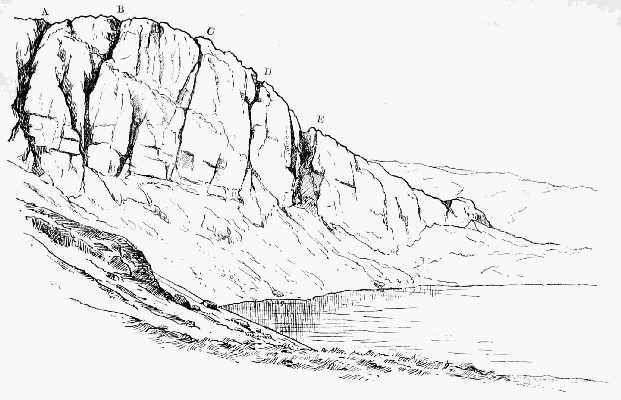
PAVEY ARK (NEAR VIEW) A, Narrow gully; B, Big gully; C, D, Smaller gullies; E, Wide scree gully. From the foot of E to A runs Jack's Rake.
In the book at Millbeck there is a note by the same distinguished climber, dated May 30, 1887, in which he records an ascent of this gully made by Miss Mabel Hastings, and gives the height of it as 600 or 650 ft.
Penyghent.—The sixth in height of the Yorkshire hills, but long supposed, on account of its finer shape, to be the highest of them all. As late as 1770 it was reckoned at 3,930 ft. It can be ascended from Horton station in little over an hour. Celtic scholars revel in the name; they practically agree that it means 'head of something,' but cannot accept each other's views as to what that something is. When Defoe was in this neighbourhood he saw 'nothing but high mountains, which had a terrible aspect, and more frightful than any in Monmouthshire or Derbyshire, especially Pengent Hill.'
Piers Gill, in Wastdale, on the north front of Lingmell, has a vast literature of its own. As a rock ravine, not in limestone, it is only second to Deep Gill on Scafell and the great gully in the Wastwater Screes, both of which are far less easy of access than this, which can be reached from Wastdale Head in half an hour. The difficulties depend entirely on the quantity of water. One, the 'cave pitch,' may be passed at the cost of a wetting almost at any time; but above it is another, known as the 'Bridge Fall,' from a vast column of fallen rock which spans the stream a few yards above it, which is at all times difficult, and in nineteen seasons out of twenty wholly impossible.
Until the unprecedented drought of 1893 it had never been climbed. Even then a less brilliant climber than Dr. Collier would scarcely have succeeded. His ascent was made on April 29, 1893, and his companions were Messrs. Winser, W. Jones, and Fairbairn. The big pitch was found to be 40 or 50 ft. high, the lowest part of it apparently overhanging. The first few feet were climbed about three feet to the right of the falling water, after which the leader was able to reach the other side of the gill by stretching his left foot across it just outside the water. By this means this great and hitherto insuperable difficulty was overcome. Unless we are entering on a cycle of dry seasons, the exploit is one which will not be repeated for some time.
Various accidents and minor mishaps have taken place in Piers Gill. One is described by Mr. Payn, and the injured man was, I believe, a shepherd called Tom Hale. Mr. W.O. Burrows had a bad fall above the bridge, and people descending from the Pikes are often pounded about the same spot. Some years ago a tourist had to pass the night in the gill without food, but protested that he was 'quite consoled by the beautiful scenery.' The discovery of the route up the east side of the Pillar Rock was within an ace of being delayed for years, owing to the band of bold explorers who were to work it out becoming entangled in Piers Gill while on their way to Wastdale Head.
The name is spelt 'Pease' by Mr. Payn and by most of the early authorities, and judging by the analogy of other places in the North of England this would appear to be more correct.
Pike o' Stickle, also known as Steel Pike and sometimes as the Sugarloaf, drops into Langdale from the north in one continuous slope, which for length and steepness has not many rivals in England. The top piece of the hill is curiously symmetrical, and resembles a haycock or a thimble. It is not easy to find satisfactory climbs on it. Mr. Gwynne says of it: 'A very fine peak, that, viewed from the valley, has very much the appearance of the Mönch. It runs down towards the Stake Pass in a spur, which must be the starting-point of most of the climbs on this mountain. There is a curious gully here, too, which is worthy of the climber's attention. It does not run from top to bottom, but suddenly begins about the middle of the crag. The difficulty is to get at this gully, and some pretty climbing can be obtained in the attempt.'
Pillar Rock.—There are but three directions from which the Pillar is commonly approached—namely, Ennerdale (Gillerthwaite), Buttermere, and Wastdale Head. In each case the guide-books (except Baddeley's) exhibit a suspicious shyness of specifying any time for the walk. Wherever the present writer gives times, they must be understood to be the quickest of which he happens to have made any note; for the best test of times is a 'reductio ad minima.' A journey may be indefinitely prolonged, but it cannot be shortened beyond a certain limit; thus, Scafell Pike cannot be reached from Wastdale Head in much less than 60 minutes of hard going, while the walk up the Pillar Fell cannot be cut down much below 75 minutes. This supplies us with a trustworthy comparison, although for a hot day that pace is not to be recommended; in each case double the time is not more than a fair allowance. Never let yourself be hurried at starting, come home as hard as ever you like; it is the chamois-hunter's system, and by far the best. Baddeley seems to reverse the principle, for he allows 2 to 2½ hours for the ascent via Black Sail, and says that it is shorter by Wind Gap; yet for the descent from Wind Gap (which is, say, 20 minutes short of the summit) he gives as a fair allowance 2 to 3 hours. Perhaps he preferred conforming to what is apparently the approved fox-hunting style:
ToList
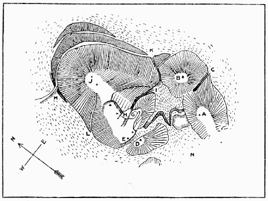
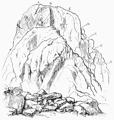
PILLAR ROCK A, B, Summits of Shamrock; C, Shamrock gully; D, Pisgah; E, High Man; G, Curtain; H, Steep Grass; I, Foot of Great Chimney; I, K, Walker's gully; J, Low Man; L, J, West route; M, Waterfall; N, I, East Scree.
Harkaway! See, she's off! O'er hill and through whol We spank till we're gaily nar done, Than, hingan a lip like a motherless fwol, Sledder heàmmward, but nit in a run.
ToList
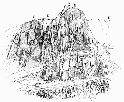
PILLAR ROCK FROM THE NORTH A, High Man; B, Low Man; C, Shamrock; D, Walker's gully; E, Below this is the waterfall. The terrace runs past the foot of Walker's gully to the foot of the waterfall.
ToList
PILLAR ROCK FROM THE SOUTH A, Top of rock and of West Jordan climb; B, Top of Central Jordan climb; C, Top of East Jordan climb; D, G, The Curtain; E, The Notch; F, The Ledge. The mass of rock in the foreground is Pisgah.
From Ennerdale: From Gillerthwaite, a farmhouse nearly a mile and a half above the lake, the Pillar is not far distant; but the direct way is exceedingly rough, and it will be found best to make use of the path up Wingate Cove, skirting round the mountain, when by that means a considerable height has been gained. The way is so rough that many people think it an economy of labour to go right on up the gap, and then left over the summit of the mountain.
One of the best ways of approaching the Pillar is to sleep at the little inn at the foot of the lake and row up from there to the water head. For walking the whole way from the inn to the fell-top Baddeley allows 3 to 3½ hours.
From Buttermere: After crossing Scarf Gap some keep to the track as far as the summit of the Black Sail Pass, and then turn to the right up the ridge of the Pillar Fell, while others adopt the more laborious plan of working upwards after descending the valley until nearly opposite the Rock, which in this way is certainly seen to much greater advantage. If the return be made by way of the mountain ridge, some little time may be saved by descending into Ennerdale down Green Cove, nearly half a mile short of Black Sail and 250 ft. higher; for Black Sail, being much nearer the head of the valley than either Scarf Gap or the Pillar, can only be used for going from one to the other at the expense of making a considerable détour. For the ascent, however, Green Cove is not so decidedly recommended, as many will prefer to make the round by the regular pass for the sake of the more gradual rise.
From Wastdale: The vast majority of visitors come from this direction, and almost all follow the same track, plodding up from Mosedale to the top of Black Sail and then turning left along the ridge of the mountain. Mosedale, by the way, must not be confused with any of the numerous other valleys of the same name: it sometimes appears in the form 'Moresdale' or 'Mossdale' (Moos-thal, near Laibach in Austria, is exactly parallel), and generally indicates scenery of a dreary character; for such valleys are often, as in this case, the half-drained beds of ancient lakes, by the loss of which the scenery has seriously suffered.
ToList
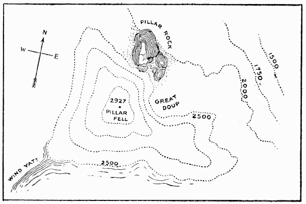
PILLAR FELL
Ladies who ascend by Black Sail will find it best to keep to the path as long as possible, i.e. as far as the top of the pass, but others may save something by breasting the hill on the left soon after reaching Gatherstone Head, apparently a glacier mound, which rises just beyond where the track crosses the stream (Gatherstone Beck) which comes down from the pass.
On reaching the ridge it is no doubt safer, especially if there be mist about, for those who are not familiar with the way to go right on to the flat top of the mountain; the proper point from which to commence the descent is easily found, in all weathers, by following the compass-needle from the cairn to the edge of the mountain; a rough and steep descent of 400 ft. follows, which in winter demands considerable care. At first the course is to the right, but it soon strikes a small ridge which curves down to the Rock. It is, however, a waste of labour to ascend to the summit of the mountain at all. The ridge of the mountain is divided into steps, and at the foot of the uppermost of these a deep cove called Great Doup is seen on the right. It may be recognised even in a mist, as it is just beyond a curious rock running out with a narrow edged top many feet from the hill-side. Less than 100 yards down the Doup the falling scree has nearly buried the cairn and iron cross erected to the memory of the Rev. James Jackson. Beyond this, as soon as the big rocks on the left permit, the track skirts round, and after one or two ups and downs comes into full view of the famous Rock. If, however, the object be to reach the north or lowest side of the Rock, it is not necessary to descend into Ennerdale from Black Sail; for there is the High Level, a fine scramble all along the breast of the mountain from Green Cove—the first large hollow on the right, just beyond Lookingsteads; but the way is rather intricate, and unless properly hit off involves considerable fatigue and loss of time. At the very least half an hour will be required in either direction, and a stranger will certainly take much longer.
Those who are anxious to pursue 't' bainest rwoad' may save ten minutes or more in the walk from Wastdale by making use of Wind Gap at the head of Mosedale. Hard work it undeniably is, but more shady than Black Sail, and—when the way is familiar, though no one can go very far wrong, unless he clings to the main valley too long and goes up to Blackem (Black Combe) Head—quicker also, occupying about ninety minutes. Mr. James Payn calls it (poetically) 'a sort of perpendicular shaft—a chimney such as no sweep would adventure, but would use the machine—which is said to be the dalesman's pass into Ennerdale; you may thank your stars that it is not your pass.'
It really adds little to the labour of this way and affords a far finer walk if the complete circuit of Mosedale be made along the hill-tops. Ascending behind the inn and keeping round just under Stirrup Crag—the north end of Yewbarrow, Dore Head is soon reached, and it is easy walking by the Chair, Red Pike, Black Crag and Wind Gap on to the Pillar Fell.
For the return to Wastdale Wind Gap is very rough and hardly to be recommended. Mr. Baddeley is not very consistent about it, for he says, 'the best descent is by Windy Gap'; but again, 'the descent from Windy Gap to Wastdale is, for reasons stated before, unsatisfactory'; and thereupon he recommends Black Sail. The latter gives a rapid descent—the inn may be reached in twenty-five minutes from the top of the pass; but a quicker return may be made by crossing the ridge after emerging from Great Doup, and shooting down Wistow Crags into Mosedale by a large gully filled with deliciously fine scree.
Should it be preferred to make the circuit of Mosedale on the return journey, an equally fine glissade may be enjoyed from Dore Head; but the screes require judicious selection and dexterity on the part of the slider.
ToList
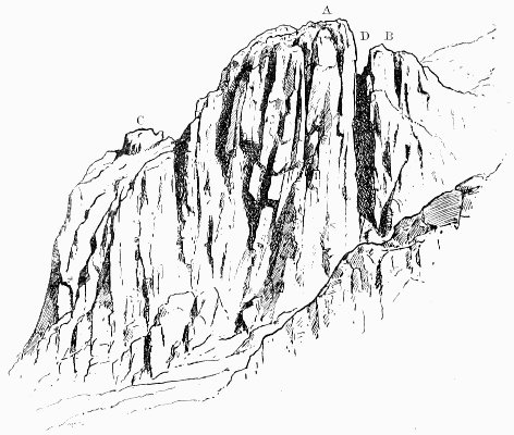
PILLAR ROCK FROM THE WEST A, Summit of High Man; B, Pisgah; C, Low Man; D, Jordan Gap. The West route ascends from this side to the depression between A and C.
It may here be said that stout walkers may visit all the mountains of Wastdale Head in one day comfortably, and in few places is a finer walk to be found. Start, say, at 10 A.M. for Scafell; then, by Mickledoor, the Pike, Great End, Sty Head, Great Gable and Kirkfell to the Pillar, returning in the manner described above in time for dinner. In June 1864, as Ritson's Visitors' Book records, J.M. Elliott, of Trin. Coll. Camb., made this round, including Steeple and Yewbarrow, and found that it took eight and a half hours; probably, however, he came over Stirrup Crag and not Yewbarrow top, which would entail something like three miles extra walking. He approached Scafell by way of Mickledoor, returning from it to the same point, and those who do not know the Broad Stand well had better follow his example; for it is a bit of a climb, and the descent especially is not easy to find. By going to Mickledoor first (and there is no shorter way to Scafell) each man can see what he has before him, and decide for himself whether it would not be better to leave Scafell out of his programme.
Before entering into the history of the Pillar it is almost indispensable to give a short general description of its main features in order to assist the comprehension of the facts narrated. Difficult as it must always be to find an image which shall supply a stranger with any clear idea of a mass so irregular and unsymmetrical as this, yet its general appearance and the arrangement of its parts may be roughly apprehended in the following manner:—Imagine a large two-gabled church planted on the side of a steep hill. From the western and loftier gable let there rise, at the end nearest the mountain, a stunted tower. Finally let the building be shattered and all but overwhelmed under an avalanche of débris. What will be the effect? Naturally the stream of stones will be much deeper above than below, and, while nearly burying the tower and upper ends of the roof, will flow along between the two gables and run off, as rainwater would do, at the far end. Angular fragments, however, remain at rest unless the slope is very steep, and consequently a long talus will be formed sloping down to the brink of the sudden drop at an angle of something like 45 degrees. Here we have a fair representation of the Pillar mass: the tower will be the High Man, and the gable from which it rises the Low Man. It will be readily understood that the second gable may be a source of some confusion to those who are ignorant that there is more than one, and from some points may disguise or altogether conceal the tower. This is why it is called the Sham Rock; but it is only from below that it would be recognised as part of the Pillar mass, for from above it is wholly insignificant. When viewed from immediately below, the tower is concealed behind the gable from which it rises, and the whole mass of rock bears a rough resemblance to the letter M; but from above, the High Man, with which alone the climber from the east side has to reckon, is also the only part of the rock which he is likely to observe. The result is that, when the Low Man is mentioned to anyone who knows only the Easy Way, the reply is usually on the model of the poet Wordsworth's only joke: 'Why, my good man, till this moment I was not even aware that there was a Low Man!' Yet the Low Man is by far the finer object of the two, and its cliffs are at least six times as high as those of what is called the High Man. The only side from which the latter shows a respectable elevation is the west, where the scree lies much lower, because it has a free escape, instead of being pent up between the two gables like the east scree.
In winter-time, when the inequalities are all smoothed over with a sheet of hard snow, both sides of the rock are rather dangerous, but especially the eastern, where a man who slipped would have the greatest difficulty in stopping himself before he shot over the precipitous gully at the end. This gully (occupying, as it were, the place of the water-pipe) is known, in allusion to an accident which occurred there in 1883, as Walker's Gully.
When the question arises of how to climb the High Man, it is obvious that the scree just above it will be the nearest point to the summit; but equally obvious that the climb, though short, would be nearly vertical. The plan which at once suggests itself for getting to the top is to work round to the back of the rock and climb it from the top of the ridge behind. The ridge may be reached from either side, and in this fact we have the secret of two of the most important climbs.
So much for the general appearance of the Pillar; but the part which admits of the easiest and most varied attack is the east wall of the High Man, and of this side it is necessary to give a more detailed description. This part of the rock is the only one which is at all well known to the general public, and its chief features, being well marked, have for the most part received, by common consent of climbers, distinctive names. In order to see the formation of the rock properly it is well worth the climber's while to descend for a few yards and mount the Sham Rock on the other side of the east scree. The peculiar structure of the opposite wall may now be clearly seen.
ToList
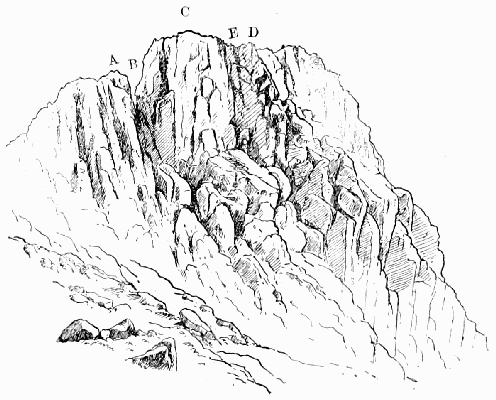
PILLAR ROCK FROM THE SOUTH-EAST A, Pisgah; B, Jordan; C, Summit; D, Top of Curtain; E, Corner between the Curtain and the main rock.
On our left hand, between the mountain and the rock, is seen an outlying mass severed from the High Man by a deep square-cut gap. When the Pillar is looked at from the direction of the mountain-top, this gap is entirely concealed by the outlying piece, which then appears to present a fairly easy way direct to the summit. 'The climber (says Mr. Williamson) mounts gaily and with confidence, only to find himself cut off from the High Man by an impassable cleft.' He sees it indeed with his eyes, but he cannot go up thither. Hence the names—Pisgah for the false rock, and Jordan for the chasm. A very well-known Pillarite once proposed to bridge the cleft with a plank or ladder and hold a tea-party on the top. This very original idea was not carried into execution, but certainly, without some such application, the passage of Jordan Gap is a formidable undertaking; for the north wall is only less vertical than the other, and though barely 60 ft. high—not much more, that is, than half as much as must be climbed by any other route—this is decidedly one of those cases in which the longer way round will prove to be the shorter way up.
On the extreme right—and rather below us—is the nearly level top of the Low Man; while not far from where broken cliffs lead up to the higher rock a curious natural post standing on the ridge marks the point from which a small deep channel is seen to come down towards Walker's Gully. This channel is of small importance, except that high up on the southern bank of it the glacier markings are most distinctly to be seen. The channel itself soon curves more towards the north and plunges over the fearful cliff which faces the Liza, forming the key to the great climb on that face. From the foot of Jordan Gap a broad smooth slope of rock runs horizontally along the face of the High Man, giving to it somewhat the formation of the 'pent-house wall' of a tennis court. The steepness of the scree, which runs down from left to right before our feet, makes the drop from this slope much greater at the Low Man end; but it will give no false idea of this side to say that, roughly speaking, the cliff is broken into three fairly equal portions, of about 60 ft. each, namely, a vertical wall above, connected with a steep and rugged part below by a smooth stretch sloping at an angle not far short of 40 degrees. The importance of this 'pent-house' is very great; for, as it gives an easy passage right across this face of the rock, every climb which is possible from below may be cut into from the side, and thus more than half the labour of the ascent is saved. Indeed, any mountain which allows its entire front to be traversed in this way by a passable ledge exposes every weak point in so reckless a manner that the attack becomes marvellously simplified.
Lastly should be noticed two rough curtains of rock which run down from the top of the Stone near the centre, and enclose between them what is called the Great Chimney. This chimney is the key to the climb on this side. The curtain on the south of it is the only one which is at all complete, and as it forms a kind of arête running up to the summit, it is known indifferently by either name—the Curtain or the Arête.
The easiest way to picture to oneself the features of the Great Chimney is to imagine a huge armchair, the 'seat' of which measures 20 yards from back to front and is tipped uncomfortably forward and downward at an angle of nearly 45 degrees. The Curtain forms the right 'arm,' and from a level with the top of the 'back,' which is 50 ft. high, runs down very nearly but not quite as far as the front edge of the 'seat.' In the narrow space thus left lies the Ledge, which makes it possible to pass round under the end of the arm and gain the 'seat,' which is called the Steep Grass. The same point may also be reached by climbing, as an alternative to the Ledge, over the lower part of the 'arm' through a deep nick—the Notch; and in either case the joint between 'arm' and 'back,' being badly cracked, offers an easy way (the 'small chimney' or 'jammed-stone chimney') of reaching the top of the back, which is the edge of a small plateau forming the summit of the High Man. Lastly, it should be noticed that the Steep Grass can only be reached from below by a severe climb of 70 ft.—the Great Chimney climb.
The side from which the Pillar is commonly climbed is not that by which the summit was first attained. The first successful attempt was made from the West, and it is doubtful whether for a quarter of a century any other route was known. But on the discovery of the Easy Way the older route was forgotten, and now enjoys a reputation for difficulty which is not deserved: it is looked upon as some little distinction to have accomplished it. In the preface to one of Wordsworth's poems the year 1826 is mentioned as the date of the first ascent. This is confirmed by a comparison of the second and third editions of Otley's 'Guide' (1825 and 1827), in the former of which the rock is declared unclimbable, while the latter mentions the victory of 'an adventurous shepherd.' The successful climber was not, however, a shepherd, but a cooper, named Atkinson, and living at Croftfoot, in Ennerdale. It is likely that his adventurous soul may have been fired by Otley's declaration that the rock was inaccessible. The perseverance of a friend has hunted out a contemporary notice of the ascent in the county paper, which remarks that, 'though the undertaking has been attempted by thousands, it was always relinquished as hopeless.' This proves, at all events, that even then the rock had a reputation. Subjoined is a list of those who have followed on Atkinson's track, so far as is known, up to 1873:
J. Colebank (shepherd);
W. Tyson (shepherd), and J. Braithwaite (shepherd);
Lieut. Wilson, R.N.;
C.A.O. Baumgartner;
M. Beachcroft and C. Tucker.
Summarising the various methods of ascending the rock, we may say that the west side first yielded in 1826; the east side probably about 1860; the south side in 1882, and the north side in 1891. The Easy Way (as it is generally called) on the east side was discovered in 1863 by a party of Cambridge men led by Mr. Conybeare, and Mr. A.J. Butler, the late editor of the Alpine Journal. Mr. Leslie Stephen had visited the rock earlier in that year without finding a way up it, but in 1865 he was more successful, and wrote an account of it in Ritson's book; the account, as usual, was first defaced and afterwards stolen. The Northeast, or Old Wall, way was discovered by Matthew Barnes, the Keswick guide, while with Mr. Graves, of Manchester. The central and western climbs from Jordan were done by the writer in 1882, as was the eastern one in 1884, the last being scarcely justifiable under any circumstances, and especially without a rope. The direct climb of the Great Chimney (starting on the south wall of it) was done about the same time, and curiously enough—for it is safe and comparatively easy—does not appear to have been done since. The long climb on the north face was accomplished by Messrs. Hastings, Slingsby, and the writer in 1891. It has been described in an illustrated article in Black and White (June 4, 1892), and by Mr. Gwynne in the Pall Mall Budget. It should not be touched except by experienced climbers.
Pinnacle Bield, on the east side of Glaramara, is a rocky part of the mountain and a famous stronghold for foxes. On the way up from Langstrath there is a very steep bit for about 500 ft.
Pisgah.—A name given in 1882 to the outlying rock on the south side of the Pillar Rock, from which it is severed by an all but impassable chasm, not seen until it bars the way. The term has in subsequent years been applied almost generically.
Pitch: any sudden drop in the course of a rock gully, usually caused by some large stone choking the channel and penning back the loose stones behind it. Such a stone is then said to be 'jammed,' 'wedged,' or 'pitched,' and is sometimes called a 'chockstone' (q.v.).
Pot-holes are frequent in the Yorkshire limestone. The rivers for considerable distances have underground courses. At each spot where the roof of one of these tunnels happens to fall in a 'pot-hole' is produced. They are very numerous about Settle and Clapham. Some are of very great depth and can only be explored with the aid of much cordage and many lights. The explorer of pot-holes has to face all the perils of severe rock climbing, and, moreover, to face them for the most part in the dark. It would be hard to imagine anything more weird than one of these darksome journeys, rendered doubly impressive by the roar of unseen waters and the knowledge that abrupt pitches of vast depth are apt to occur in the course of the channel without the slightest warning. (See Alum Pot, Dunald Mill Hole, Gaping Gill Hole.)
Pow: a sluggish rivulet.
Professor's Chimney.—A name bestowed by Messrs. Hopkinson on the exit most towards the left hand as one comes up Deep Gill on Scafell. Out of this chimney, again to the left, diverges that which leads up to the neck between the Scafell Pillar and its Pisgah. To this latter chimney the name is erroneously applied by many, though, indeed, they might urge with some reason that if it comes to a scramble for one name between two gullies the more frequented ought to get it.
Rainsborrow Crag.—A noble rock in Kentdale, Westmorland. It is, perhaps, most easily got at from Staveley, but from Ambleside it is only necessary to cross the Garbourne Pass, and the crag is at once conspicuous. It is of the same type as Froswick and Ill Bell, but finer and more sheer than either of them.
Rake: a word common in Derbyshire, Yorkshire, and the Lakes, which has been much misunderstood. It usually happens to be a scree-gully, but the fundamental idea is straightness.
Rake's Progress.—This is a natural gallery on the face of the Mickledoor crags of Scafell. It has been best described by Mr. Williamson, who says: 'Mickledoor may be reached by scrambling up the steeply sloping screes which form its Wastdale slope; but the easier and more romantic approach is by the grassy ledge, which will be seen projecting from the face of the Scafell precipice. This ledge or shelf is in but few places less than four feet wide. In places it is composed of shattered heaps of rock, which seem barely to keep their equilibrium; but though there is a precipice of considerable height on the left hand, the passage along the ledge is free from risk so long as the rock wall on the right is closely hugged. By one who watched from below the passage along the ledge of some of the early pioneers of lake climbing it was christened the Rake's Progress, and the name appears apt when it is remembered that the ledge leads from the lower limb of the Lord's Rake to the Mickledoor Ridge.' The first published description of the Rake's Progress is contained in a letter by the late Mr. Maitland to one of the local papers in October 1881. He there states that he had recently traversed it for the fifth time, but had not previously to that occasion visited Deep Gill. Several grand climbs start from the Progress, including North Climb, Collier's Climb, Moss Gill, Steep Gill, and the Scafell Pillar.
Raven Crag.—This name is generally the sign of a hard, if not of a good, climb. One of the finest stands on the west side of Thirlmere, near the foot, or what used to be the foot of it before Manchester took it in hand; a second is on the Pillar Fell just east of the rock; a third and fourth on Brandreth and Gable, and indeed there is one on almost every fell.
Red Pike, in Cumberland, overlooking Buttermere, is a syenite hill, and commands a glorious view, especially strong in lakes, but there is next to no climbing to be had on it. The best way up it is to follow the course of Ruddy Beck from the southernmost corner of Crummock Water, but the rocky amphitheatre in which Bleaberry Tarn lies is better seen if the somewhat rougher route by Sourmilkgill and its east bank be followed.
Red Pike, also in Cumberland, is a Wastdale fell, and lies between Yewbarrow and the Steeple. The north side of it has abundance of small climbs, which, with the exception of Yewbarrow, are, perhaps, more easily reached than any others from the inn at Wastdale Head; but they are little visited, because everyone wants to fly at the highest game and do the climbs which are most talked about. This fell is sometimes called Chair, from the fact of there being a curious stone seat on it near the ridge, and not far from Door Head.
Red Screes, in Westmorland (2,541 ft.), are very steep in the direction of the Kirkstone (after which the pass of that name is said to be called), falling about 1,000 ft. in a horizontal distance of a quarter of a mile; but the ascent is not more than an exhilarating scramble. There is a well-known view from the top.
Rope.—Some remarks on the use of the rope as a safeguard in climbing will be found in the Introduction.
Rossett Gill.—A rough pass just over 2,000 ft. in height, which is the only approach from Langdale to Scafell, Gable, and the Wastdale fells generally. On the Langdale side you cannot go far wrong, but it is very rugged, so rugged that Mr. Payn has caustically observed that all expeditions in this region admit of being made by driving, by riding, or by walking, 'except Rossett Gill, which must be done on all fours.' On the Eskhause side the walking is perfectly easy, but mistakes are very liable to occur. On this high ground mists are extremely frequent, and blinding rain is abundant. The result is that people making for Langdale are surprised at having to mount again after the long descent to Angle Tarn, and often end by going away to the left down Langstrath, and find themselves to their great surprise in Borrowdale. The only safeguard is, of course, to bear clearly in mind that the ups and downs hereabout are considerable, and to arm oneself with map and compass.
Saddleback (2,847 ft.) was at one time thought to be higher than its neighbour Skiddaw. To Mrs. Radcliffe, on the summit of the latter in 1795, the former was 'now preeminent over Skiddaw.' 'The Beauties of England' informs us that 'the views from the summit are exceedingly extensive, but those immediately under the eye on the mountain itself so tremendous and appalling that few persons have sufficient resolution to experience the emotions which those awful scenes inspire.' We have a very full account of an ascent made in 1793. The narrator says: 'When we had ascended about a mile, one of the party, on looking round, was so astonished with the different appearance of objects in the valley so far beneath us that he declined proceeding. We had not gone much further till the other companion (of the relator) was suddenly taken ill and wished to loose blood and return.'
The great feature of the mountain is its southern front, which is cut away to form enormous cloughs, divided by narrow ridges. The latter are the Edges of Saddleback. Narrow Edge (as Halls Fell top is now generally called) is the finest and most romantic. It runs up from Threlkeld, where there is a convenient station. The proper name of Broad Edge is Gategill Fell. Part of Middle Tongue straight behind the lead-mine is also very narrow. A writer in the Penny Magazine for 1837 speaks of 'the serrated precipices above Threlkeld,' and adds, 'One of these is called Razor Edge.' That name, however, has now for many years at least been used as the equivalent of Sharp Edge, which is on the east side of the mountain and on the north side of Scales Tarn, and at one time enjoyed a tremendous reputation as a perilous climb.