BURIAL MOUNDS OF THE ILLINOIS OR UPPER MISSISSIPPI DISTRICT.
Reading edition
This district, as heretofore stated, includes eastern Iowa, northeastern Missouri, and northern and central Illinois as far south as the mouth of the Illinois River.
Although we are justified in concluding that this area was occupied during the mound-building age by tribes different from those residing in the Wisconsin district, yet the distinguishing characteristics are more apparent in the forms of the works than in the modes of burial and internal construction of the burial mounds. We shall see by the illustrations hereafter given that at least one of the types found in one district is common in the other. But this is to be expected and is readily explained by the supposition that the tribes which have occupied these regions moved back and forth, thus one after another coming upon the same area. The absence of evidence of such movements would indicate that the mound-building period was of comparatively short duration, a theory which I believe has not been adopted by any authority, but to which I shall have occasion again to refer. One class of the burial mounds of this district is well represented in a group, explored by the members of the Davenport Academy of Natural Sciences, on the Cook farm, near Davenport, Iowa. The mounds of this group are situated on the immediate bank of the Mississippi at a height not exceeding 8 to 12 feet above high-water mark; they are conical in form and of comparatively small size, varying in height from 3 to 8 feet. Nine of them were opened, of which we notice the following:
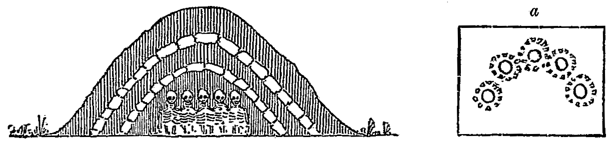
Fig. 7.—Section of burial mound, Davenport, Iowa. [From the Proceedings of the Davenport Academy of Sciences.]
In No. 1 the layers from above down were, first, a foot of earth; then a layer of stones 1½ feet thick; then a layer of shells 2 inches thick; next a foot of earth, and lastly a second layer of shells 4 inches thick. Immediately under this, at the depth of 5 feet, were found five skeletons stretched horizontally on the original surface of the ground, parallel to each other, three with heads toward the east and two with heads west. With them were found one sea-shell (Busycon perversum), two copper axes, to which fragments of cloth were attached, one copper awl, an arrow-head, and two stone pipes, one representing a frog.
Mound No. 2, though similar in form and external appearance to the preceding, presented a quite different arrangement internally, as is evident from the vertical section shown in Fig. 7. Here there were no layers of shells, but two distinct layers of stones. At the depth of 5 feet eight skulls (five only are shown in the figure), with some fragments of bones were unearthed; these were lying in a semicircle of 5 feet diameter, each surrounded by a circle of small stones (shown at a in the figure). From the position of the skulls and bones it was evident these bodies had been buried in a sitting posture. The articles found accompanying the skeletons were two copper axes, two small hemispheres of copper and one of silver, a bear's tooth, and an arrow-head.
No. 3, though the largest of the group, was apparently unstratified, the original burial consisting of the bones of two adults and one infant, at the original surface of the ground, under a thin layer of ashes, and surrounded by a single circle of small red stones. With these were found copper axes, copper beads, two carved stone pipes (one in the form of a ground-hog), animal teeth, etc. Near the surface of the mound were two well-preserved skeletons, with evidences of an "oakwood" covering over them and accompanied by glass beads, a fire steel, clay pipe, and silver ear-ring—evidently an intrusive burial.
No. 4 was found similar in construction and in all other respects to No. 3, except that at the feet of the skeletons was a round heap of stones, 3 feet high, neatly laid up, and that in the earth where the skeletons lay could be distinctly seen traces of cloth or some woven material, in which they had probably been enveloped.
No. 5 was similar to No. 2, except in the following respects: The skeletons (probably two) were in a confused heap at the bottom under a 6-inch layer of hard clay (probably similar to what Colonel Norris calls "mortar"). Near these, but outside of the clay layer, was a stone heap similar to that in No. 4. "On this lay two very strong thigh bones and three ribs placed diagonally across each other. There were also a few bones leaning against the heap at one side. The stones were partly burned to lime, and all of them showed more or less marks of fire, while the bones in the mound showed not the slightest trace of it."
Four or five feet south of the stone heap was a large quantity of human bones in complete confusion. The relics were broken pots, arrow-heads, a stone pipe, etc.
Nos. 7, 8, and 9 were similar to No. 1, varying only in minor details.[14]
My object in noticing the construction of so many mounds in a single group and the modes of burial in them, is to call attention to the differences in detail where there can be no doubt that they were built by one tribe and probably by one clan, as the size of the group indicates a comparatively limited population. In these nine mounds we notice the following differences: some are stratified, others not; in some the skeletons are placed horizontally on the ground, in others they are in a sitting posture, while in others they are dismembered and in confused heaps; in some there are altar-like[15] structures of stone which are wanting in others; in some the skeletons are covered with a hard clay or mortar coating which is wanting in most of them, and lastly, we see in one or two, evidences of the use of fire in the burial ceremonies, though not found in the others.
In some respects these mounds remind us of some of the stratified tumuli of Wisconsin, especially those opened by Colonel Norris in Sheboygan County, to which they bear a strong resemblance.
In the latter part of 1882 Colonel Norris examined a group of works in Allamakee County, Iowa, which presents some peculiarities worthy of notice in this connection.
This group, which is represented in Plate I, consisting of enclosures, lines of small mounds, and excavations, is situated on the farm of Mr. H. P. Lane, about 7 miles above New Albin. It is on a bluff in one of the numerous bends of the Little Iowa River, the character of the locality indicating that it was selected as one easily defended. I shall at present only notice those particulars which seem to have some bearing on the character of the burial mounds and mode of interment.
Although there are no effigy mounds in the group, the relative positions and forms of the tumuli, as shown in the figure, and other particulars to be noticed, leave no doubt in my mind that the works, in part, are to be attributed to the people who built the figure mounds of Wisconsin. But, as will be seen from the particulars mentioned, there is conclusive evidence that the locality has been occupied at different times by at least two distinct tribes or peoples, differing widely in habits and customs.
PL. I. GROUP OF EARTHWORKS, ALLAMAKEE COUNTY, IOWA
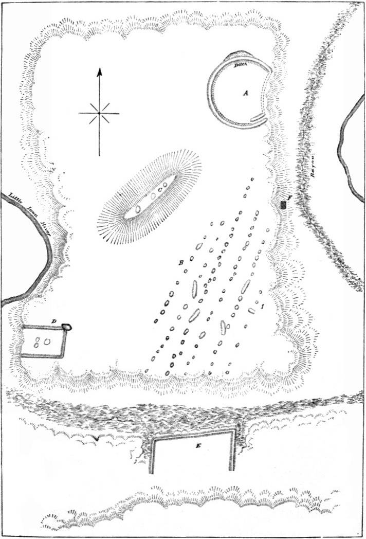
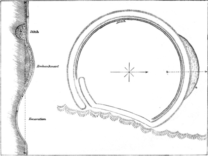
The largest work is an enclosure marked A in Plate I, and shown on an enlarged scale in Plate II. It is situated on the margin of a bluff overlooking the Little Iowa and an intervening bog-bayou, probably the former channel of the river. It is almost exactly circular, the curve being broken on the east side, where it touches the brink of the bluff, being here made to conform to the line of the latter, though probably never thrown up to the same height as the other portion. The ends at the southeast overlap each other for a short distance, leaving at this point an entrance way, the only one to the enclosure. A ditch runs round on the inside from the entrance on the south to where the wall strikes the bluff on the north, but is wanting along the bluff and overlapping portion. The north and south diameter, measuring from outside to outside, is 277 feet; from east to west, 235 feet; the entire outer circumference is 807 feet, the length of the portion along the bluff 100 feet, and of the overlapping portion at the entrance 45 feet. The wall is quite uniform in size, about 4 feet high and from 25 to 27 in width, except along the bluff, where it is scarcely apparent; the entrance is 16 feet wide, and the ditch 5 to 6 feet wide and 3 feet deep. On the north, adjoining the wall on the outside and extending along it for about 100 feet, is an excavation (c, Plate II) 35 feet wide at the widest point and 3 feet deep.
As this ground, including the circle, has been under cultivation for fifteen years, it would be supposed the height of the wall is considerably less than it originally was, but this is probably a mistake. On the contrary, it was originally probably but 20 feet wide and not more than 3 feet high, composed mainly of yellowish brown clay obtained, in part at least, from the ditch, but during occupancy the accumulation of countless bones of animals used as food, stone chips, river shells, broken pottery, and dirt, and, since abandonment, the accumulation of sand drifted by the winds from the crumbling sandstone butte (C, Plate I) overlooking it, have not only filled the ditch but elevated the wall and whole interior area 2 feet or more. This accumulation of sand is so great and so uniform over the plateau that fifteen years of cultivation have not sufficed to reach the clay of the original surface nor to unearth or even penetrate to the bones, pottery fragments, and other refuse matter covering the original surface in the circle.
Trenches cut across the wall at various points indicate, first, a layer of sand about 1 foot thick; immediately below this an accumulation of refuse matter forming a layer from 1 to 2 feet thick; under which was the original clay embankment 2 feet thick, resting on the natural surface of the ground. A section of the ditch, embankment, and excavation is shown in Plate II. The dotted line a b indicates the natural surface; No. 1 the original clay layer of the wall; No. 2 the layer of earth and refuse material with which the ditch is filled; and No. 3 the top layer of sand.
In No. 2 were found charcoal, ashes, fragments of pottery, fractured bones, etc.
A broad belt of the inner area on the east side was explored, and the same conditions were found to exist here as were revealed by the trenches across the wall and ditch, except that here the shells were more abundant in layer No. 2, and there were many burnt stones.
On the southeastern portion of the plateau (B, Plate I) are six nearly parallel lines of mounds running northeast and southwest, mostly circular in form, varying from 15 to 40 feet in diameter, and from 2 to 6 feet in height; a few, as indicated in the figure, are oblong, varying in length from 50 to 100 feet. The number in the group exceeds one hundred.
While engaged in excavating these mounds Colonel Norris observed a number of patches of the level area quite destitute of vegetation. The owner of the land, who was present, could give no explanation of this phenomenon, simply remarking that they had always been so, never having produced a good crop of anything, although there was no apparent difference between the soil of these spots and the surface around them. As some of these extended across the area occupied by the mound group, he concluded to explore them, and was surprised to find them to be burying places, and scattered here and there among the graves, if such they could be called, were stone chips, shells, charcoal, and ashes. He was surprised at this, as he supposed the mounds alone were used as depositories of the dead, and was at first disposed to attribute these burials to a people who had occupied the ground long subsequent to the authors of the works. Possibly this may be the correct solution, but if so, they were certainly the same as those who buried in the mounds of this group, as no difference in the contents and internal arrangement could be observed. In both cases there was a compact layer of hard, light-colored earth, having the appearance of lime-mortar, possibly clay and ashes mixed together, which had been subject to the action of fire. As the burials in these sterile spots were seldom more than 18 inches deep, the only layer above them consisted of sand from the butte, while the mounds were uniformly covered with a layer of richer soil, although below this and covering the skeletons was a layer of hard, light-colored earth. Skeletons and bones were found in great abundance in the mounds and under the surface of the plateau, though none were discovered in the circle or nearer than 200 yards of it. They were sometimes mingled promiscuously with charcoal and ashes, but were usually in whole skeletons lying horizontally, though some were in a sitting posture; they were within from 1 to 3 feet of the surface, without any apparent system, except that they were always covered with a layer of hard earth.
A trench cut through the long mound of this group, No. 1, revealed near the center an oblong pile of sandstones, beneath which was found a rude stone coffin, formed by first placing flat sandstone slabs on the natural surface of the ground, then other slabs at the sides and ends, and a covering of similar stones, thus forming a cist or coffin about 6 feet long and 18 inches wide. Within this, extended at full length, with the head west, was the skeleton of an adult, but too much decayed for preservation. With it were some stone chips, rude stone scrapers, a Unio shell, and some fragments of pottery similar to those dug up in the circular enclosure.
The mounds on the sand butte marked C, Plate I, which is something over 100 feet high, were opened and found to be in every respect similar to those already mentioned, showing them to be the work of the same people who built the others.
The three mounds in the square enclosures marked D, (Plate I), were also opened, with the following results: The largest, oval in form, 30 feet long, about 20 feet broad and 4 feet high, was found to consist of a top layer of loose sand 1 foot thick, the remainder of hard yellowish clay. In the latter were found several flat sandstone fragments, and beneath them, on the original surface of the ground, a much decayed skeleton, with which were a few stone chips, Unio shells, and fragments of pottery.
The second in size, 18 feet in diameter and 3 feet high, although covered with a layer of sand, was mainly a loose cairn of sandstones, covering traces of human bones, charcoal, and ashes. The third was found to be similar to the second, but in this case the pile of stones was heaped over a mass of charred human bones, mingled with which were charcoal, ashes, and fragments of pottery.
Fragments of pottery were found in abundance in the circle, in the mounds, in the washouts, and in fact at almost every point in the area covered by the group. Judging by the fragments, for not a single entire vessel was obtained, the prevailing forms were the ordinary earthen pot with ears, and a flask or gourd-shaped vase with a rather broad and short neck, often furnished with a lid. The paste with which this pottery was made had evidently been mixed with pounded shells. The only ornamentation observed consisted in the varied forms given the handles or ears and indentations and scratched lines.
Nearly all the implements found were of stone, exceedingly rude, being little else than stone flakes with one sharp edge; many of them having been resharpened and used as knives, scrapers, and skinners. Some had been worked into moderately fair perforators or drills for making holes in horn, bone, and shell—specimens of all these, with such holes, having been found here.
The immense quantity of charred and fractured bones, not only of fish, birds, and the smaller quadrupeds, such as the rabbit and the fox, but also of the bear, wolf, elk, deer, and buffalo, shows that the occupants of this place lived chiefly by the chase, and hence must have used the bow and arrow and spear; yet, strange to say, although careful search was made for them, less than a dozen arrow and spear heads were found, and these so rude as scarcely to deserve the name. A single true chipped celt, three sandstones with mortar-shaped cavities, and a few mullers or stones used for grinding were obtained; also, some fragments of deer-horn, evidently cut round by some rude implement and then broken off, and several horn and bone punches and awls, one barbed and another with a hole through the larger end.
The object in view in presenting these details is to give the reader an opportunity of judging for himself in reference to some inferences drawn from them.
The form of the circular enclosure reminds us at the first glance of the palisade enclosures figured by De Bry,[16] which, according to Lafitau,[17] was the form usually adopted by the Indian tribes who were accustomed to erect such structures. We have here the almost exact circle, save where interrupted by the margin of the bluff, the overlapping of the ends, and the narrow entrance-way. We have here also the clay with which it was the custom, at least in the southern section, to plaster the palisades or which was cast against their bases as a means of supporting or bracing them at the bottom, a custom not entirely unknown among the northern tribes in former times.
The indications are therefore very strong that this enclosing wall was originally a palisade which had been in part plastered with clay, or against which clay had been heaped to assist in rendering it firm and secure, and, if so, then it is probable it was built by Indians.
Be this supposition right or wrong the evidence is conclusive that the area on which this group is situated has been the abode of at least two tribes or peoples: first, it was occupied by the authors of the enclosures, whose stay was probably not very protracted, and after they had abandoned the locality or been driven from it by a second tribe, evidently comparatively numerous, that made it for a long time a dwelling place; a tribe differing in customs from its predecessor, and one that did not rely upon enclosures for protection. By no other supposition can we account for the fact that the refuse layer which covers the interior of the circle also spreads in equal depth over the ditch and clay remains of the enclosing wall, as those who left this refuse layer could have made no possible use of the wall as a defensive work, for which the position chosen and other particulars show it was designed.
The form of this enclosure, as we have before intimated, seems to connect it with some one of the Indian tribes; its age is uncertain but the accumulation of refuse matter and sand since the abandonment by the first occupants indicates considerable antiquity.
Although we cannot say positively that the second occupants were the builders of the mounds, as the investigation was not as thorough as it should have been, still I think we may assume, with almost absolute certainty, that such was the fact. The mounds in the square work marked D, in Plate I, present considerable differences from those in the group, and are probably the work of those who built the enclosures.
The stone grave in the oblong mound indicates the presence of individuals of a more southern tribe[18] at this place, during its second occupancy. The position of the cist in the mound would seem to forbid the idea of an intrusive burial, otherwise I should certainly suppose such to be the fact. I cannot, in the present paper, enter into a discussion of the question "to what tribe or people are the box-form stone graves to be attributed," but will state my conviction to be, after a somewhat careful study of the question, that they are to be ascribed to the Shawnees, Delawares, and Kickapoos.
PL. II. ENLARGED FIGURE AND SECTION OF EARTHWORK A, PL. I.
Without further discussion of this group, which, as before intimated, presents, so far as the mounds are concerned, some features which appear to ally the latter to one class of burial mounds found in Wisconsin, we will now refer to some other works of this district explored by the Bureau assistants.
On the land owned by Mr. Fish, in Iowa, near the Mississippi River, a short distance below where the Little Iowa joins it, is a group of mounds placed on the crest of a ridge running parallel with the former stream about one-fourth of a mile therefrom. There are in all about thirty of these mounds, circular in form, and varying from 20 to 40 feet in diameter. These are all burial mounds, but one singular feature observed is that those on the higher sandy ground, although about the same size and having cores of clay similar to those on the firm clay portion of the ridge, have a layer of sand, some two feet or more added to them, yet when opened the contents and mode of construction of the two classes were found to be the same, to wit, a layer of hard clay covering decaying human bones, fragments of pottery, and rude stone implements. There were generally two or more skeletons in a mound, which were placed horizontally side by side on the natural surface of the ground.
Fig. 8.—Section of mound showing stone vault (Iowa).
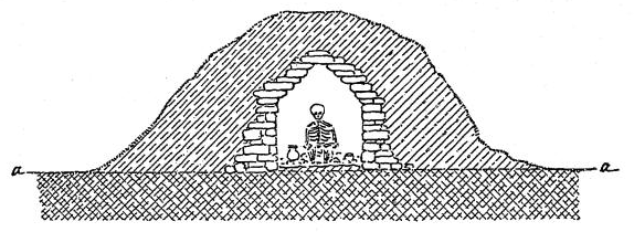
Upon the terrace below the group were found the remnants of a row of comparatively large burial mounds. A railroad line having been carried along here, the larger portion of these works were destroyed; still, enough remained to show that the height varied from 6 to 15 feet, that they were composed chiefly of sandy loam similar to that around them, and that each had a hard central core of clay mixed with ashes, usually covering but a single skeleton. The relics found in them when opened consisted chiefly of stone axes, arrow and spear heads, and a few copper celts. In one, which was 32 feet in diameter and 8 feet high and less injured than the others, was a circular vault, walled as represented in Fig. 8. This was built of flat, unworked stones, laid up without mortar, gradually lessening as it ascended, and covered at the top by a single flat stone. In it was a single skeleton in a squatting posture, with which was a small earthen vase of globular form.
A singular fact was observed in a group near the town of Peru, Dubuque County. This group is situated on a dry, sandy bench or terrace some 20 feet or more above a bayou which, makes out from the Mississippi. It consists chiefly of small circular tumuli, but at the north end are four oblong mounds varying in length from 40 to 110 feet and in height from 1½ to 4 feet; there is also an excavation about 30 feet in diameter and 6 feet deep, and scattered throughout the group are a number of circular earthen rings varying in diameter from 12 to 30 feet and from 1 to 2 feet in height.
Quite a number of the circular mounds were opened, but only detached portions of a skeleton were found in any one, as a skull in one, and a leg, arm, or other part in another, four or five adjacent ones apparently together containing the equivalents of an entire skeleton. Some of these bones were charred, and all were much decayed, indicating by their appearance great age. The inner portion of the mounds consisted of hard, compact earth, chiefly clay, resembling in this respect most of the burial mounds of this region.
Unfortunately the examination of this group was too partial and too hastily made to enable us to form any theory as to the meaning of this singular mode of burial, or even to be satisfied that the idea of our assistant in this regard is correct.
As possibly having some bearing upon the question, the following facts relating to another similar group at Eagle Point, three miles above Dubuque, are given.
This group, which is situated on a bluff about 50 feet above highwater mark, consists of about seventy mounds, all of which, except two oblong ones, are small and conical in form. Eleven of these circular tumuli were thoroughly explored, but nothing was found in them except some charcoal, stone chips, and fragments of pottery. But in an excavation made in the center of a long mound just west of the group were found two decayed skeletons. Near the breast of one of them were a blue stone gorget and five rude stone scrapers; with the other, thirty-one fresh-water pearls, perforated and used as beads. Excavations were made in an oblong and circular mound near the extreme point of the bluffs. Each was found to have a central core of very hard clay mixed with ashes, so hard in fact that it could only be broken up with the pick, when it crumbled like dry lime mortar, and was found to be traversed throughout with flattened horizontal cavities. These cavities were lined with a peculiar felt-like substance, which Colonel Norris, who opened the mounds, was satisfied from all the indications pertained to bodies which had been buried here, but from lapse of time had entirely crumbled to earth save these little fragments. We are therefore perhaps justified in concluding that a more thorough and careful examination of the mounds of the other group would have shown that the skeletons had so far decayed as to leave but a small part in a mound. Nevertheless it is proper to state that Colonel Norris does not coincide with this conclusion, but thinks that the dismembered skeletons were buried as found. Possibly he is correct.
In this connection, and before referring to the mounds of this district on the Illinois side of the Mississippi, I desire to call attention to some modern Indian burials in this region. As the statements here made are from one claiming to be an eye-witness, I give them as related to the Bureau assistant.
Fig. 9.—Plat of Indian burying-ground, Wapello County, Iowa.
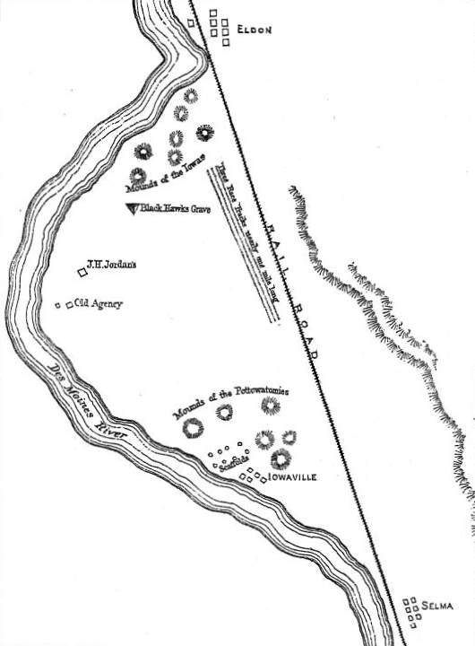
The locality is a level plat in a bend of the Des Moines River between Eldon and Iowaville, Wapello County. The plat of this area and the sites of the burial places, as shown in Fig. 9, are based upon the statements of Mr. J. H. Jordan (the person referred to), who has resided here since the close of the Black Hawk war, and was the agent of the Sacs and Foxes from their removal hither after the war until Black Hawk's death, September 15, 1838.[19]
The extreme width of the area represented is about 2 miles. Close to the point of the bend formerly stood the agency building, near which is the present residence of Mr. Jordan. The triangle marks the position of Black Hawk's grave; the parallel lines, the race-tracks; the rings in the upper corner, the mounds of the Iowas; those in the lower corner, near Iowaville, the mounds of the Pottawattamies; and the open dots, near the same point, the place where the scaffolds for their dead stood.
Mr. Jordan says:
"This valley had long been a famous haunt for the warring Indians, but was, at the time of my first personal acquaintance with it, in possession of the Iowas, whose main village was around the point where my present residence now stands. The race-course consisted of three hard beaten parallel tracks nearly a mile in length, where the greater portion of the Iowa warriors were engaged in sport when Black Hawk surprised and slaughtered a great portion of them in 1830. After Black Hawk and his warriors had departed with their plunder, the remaining Iowas returned and buried their dead in little mounds of sod and earth, from 2 to 4 feet high, at the point indicated on the diagram.
"After the Black Hawk war was over, the remnant of the Iowas, by treaty, formally ceded their rights in this valley to the Sacs and Foxes. At this place this noted chief was buried, in accordance with his dying request, in a full military suit given him by President Jackson, together with the various memorials received by him from the whites and the trophies won from the Indians. He was placed on his back on a 'puncheon' [split slab of wood], slanting at a low angle to the ground, where his feet were sustained by another, and then covered with several inches of sod. Over this was placed a roof-shaped covering of slabs or 'puncheons,' one end being higher than the other; over this was thrown a covering of earth and sod to the depth of a foot or more, and the whole surrounded by a line of pickets some 8 or 10 feet high."
Here we have evidence that some at least of the Indians of this region were accustomed to bury their dead in mounds down to a recent date.
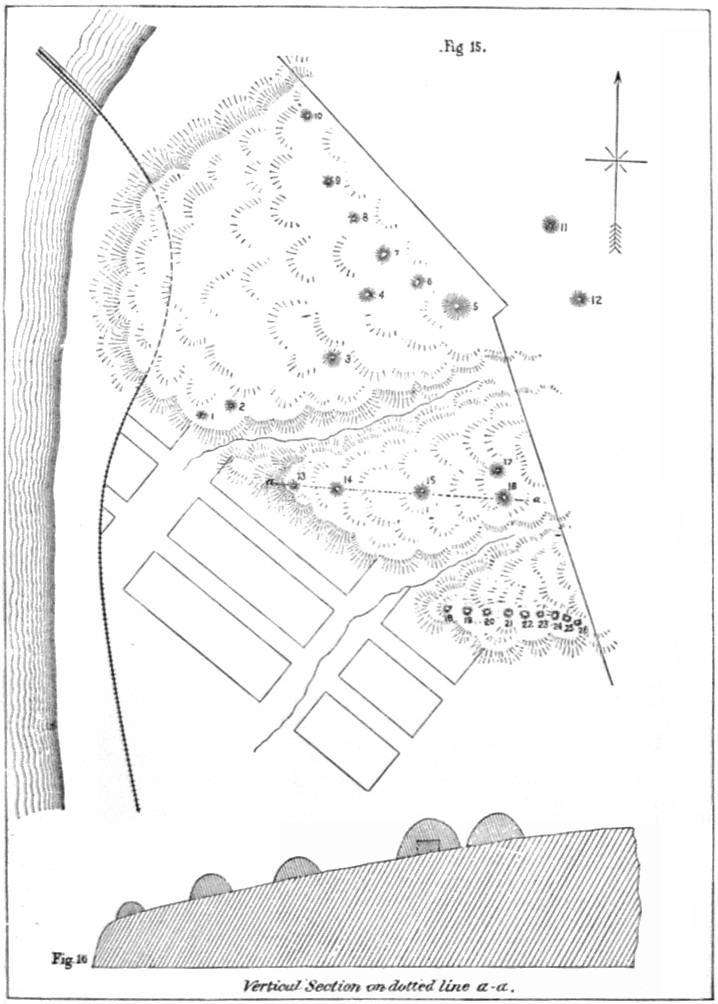
One of the most important burial mounds opened in this district by the employés of the Bureau is situated on the bluff which overhangs East Dubuque (formerly Dunleith), Jo Daviess County, Illinois. As I shall have occasion to refer to others than the one mentioned, I give in Fig. 15, Plate III, a plan of the group, and in Fig. 16, same plate, a vertical section of the bluff along the line of mounds numbered 13, 14, 15, 16, and 17, in which is seen the general slope of the upper area.
The mounds of this group are conical in form, varying from 12 to 70 feet in diameter and from 3 to 12 in height. All appear to have been built for burial purposes.
In No. 5, the largest of the group, measuring 70 feet in diameter and 12 feet in height, a skeleton, apparently an intrusive burial, was found at the depth of 2 feet immediately below the apex. Near the original surface of the ground, several feet north of the center, were the much-decayed skeletons of some six or eight individuals of every size from the infant to the adult. They were placed horizontally at full length with the heads toward the south. A few perforated Unio shells and some rude stone skinners and scrapers were found with them. Near the original surface, some 10 or 12 feet from the center, on the lower side, was discovered, lying at full length on its back, an unusually large skeleton, the length being something over 7 feet. It was all distinctly traceable though it crumbled to pieces immediately after removal from the hard earth in which it was encased. With it were three thin, crescent-shaped pieces of roughly-hammered native copper, respectively 6, 8, and 10 inches in length, with some small holes along the convex margin; also a number of elongate copper beads, made by rolling together thin sheets, and a chert lance-head 11 inches long; the latter was placed near the left thigh. Around the neck were the remains of a necklace of bears' teeth. Lying across the thighs were dozens of small copper beads, evidently formed by rolling slender wire-like strips into small rings. The assistant who opened this mound, and who is personally well acquainted with Indian habits and customs, suggests that these beads once formed the ornamentation of the fringe of a hunting shirt.
As No. 4 of this group presents some peculiarities, I take the description from Colonel Norris's notes:
During a visit to this locality in 1857, he partially opened this mound, finding masses of burned earth and charred human bones mingled with charcoal and ashes. At his visit in 1882, on behalf of the Bureau, a further examination revealed, on the lower side, the end of a double line of flat stones set on edge, about a foot apart at the bottom and leaned so as to meet at the top and form a roof-shaped flue or drain. Following this up, he found that it extended inward nearly on a level, almost to the center of the mound, at which point it was nearly 3 feet below the original surface of the ground. Here a skeleton was discovered stretched horizontally in a vault or grave which had been dug in the ground before the mound was cast up. Over that portion below the waist (including the right arm) were placed flat stones so arranged as to support one another and prevent pressure on the body, but no traces of fire were on them; yet, when the upper portions of the body were reached, they were found so burned and charred as to be scarcely traceable amid the charcoal and ashes that surrounded them.
It was apparent that a grave had first been dug, then the right arm had been dislocated and placed by the side of the skeleton below the waist, and this part covered with stones as described, and then the remainder burned by a fire kindled over it.
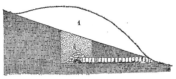
A section of the mound showing the grave and stone drain is given in Fig. 10, in which 1 is the outline of the mound on the hill slope; 2, the pit; and 3, the stones of the drain.
Fig. 10.—Section of mound 4, East Dubuque, Illinois.
No. 13 was found to contain a circle or enclosure, 10 feet in diameter, of stone slabs set on edge at the natural surface of the ground. Within this circle, but some 2 feet below the surface, were five skeletons: two adults, two children, and one infant. They were all lying horizontally, side by side, with heads south, the adults at the outside and the children between them.
We are reminded by the mode of burial in this case of that in the mound opened by Dr. Lapham at Waukesha, Wisconsin, before referred to. In that the remains of a single individual were discovered, but in this it would seem that the skeletons of an entire family, gathered from their temporary resting places, had been carefully buried side by side, a silent testimonial to parental love and affection of friends among the mound-builders.
No. 1, 6 feet high and 45 feet in diameter, was found to be an ossuary. Beneath the top layer was an arched stratum of clay and ashes mixed, so firm and hard as to retain its form unsupported over a space of several feet. This covered a confused heap of human bones, many of which were badly decayed.
The marked feature of the group was found in No. 16, a remarkably symmetrical mound 65 feet in diameter and 10 feet high. After passing downward 6 feet, mostly through a hard gray layer, a vault partly of timber and partly of stone was reached. A vertical section of the mound and vault is shown in Fig. 11, and the ground plan of the vault in Fig. 12.
This vault or crypt was found to be rectangular in form, inside measurements showing it to be 13 feet long and 7 feet wide, surrounded by a sandstone wall 3 feet high. Three feet from each end was a crosswall or partition of like character, thus forming a main central chamber 7 feet square, and a narrow chamber or cell at each end something over 2 feet wide and 7 feet long. The whole had been completely covered with a layer of logs from 6 to 12 inches in diameter, their ends reaching slightly beyond the side walls in the manner shown in Fig. 12.
PL. III. GROUP OF MOUNDS AND VERTICAL SECTION OF BLUFF, EAST DUBUQUE, ILL.
In the center chamber were found eleven skeletons: six adults and five children of different ages, including one infant, the latter evidently buried in the arms of one of the adults, possibly its mother. Apparently they had all been buried at one time, arranged in a circle, in a squatting or sitting posture, against the walls. In the center of the space around which they were grouped was a fine specimen of Busycon perversum, which had been converted into a drinking-cup by removing the columella. Here were also numerous fragments of pottery.
Fig. 11.—Section of mound 16 (Pl. III) showing vault.
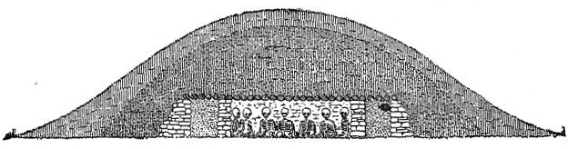
Fig. 12.—Plan of vault, mound 16 (Pl. III).
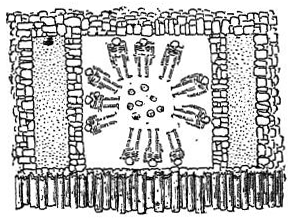
The end cells, walled off from the main portion, as heretofore stated, were found nearly filled with a very fine chocolate-colored dust, which gave out such a sickening odor that the workmen were compelled to stop operations for the day in order to allow it to escape.
The covering of the vault was of oak logs, most of which had been peeled and some of the larger ones somewhat squared by slabbing off the sides; and the slabs and bark thus removed, together with reeds or large grass stems, had been laid over them. Over the whole was spread layer after layer of mortar containing lime, each succeeding layer harder and thicker than that which preceded it, a foot or so of ordinary soil completing the mound.
As there can be scarcely a doubt that the mounds of this group were built by one tribe, we have here additional evidence that the same people were accustomed to bury their dead in various ways. Some of the skeletons are found lying horizontally side by side, others are placed in a circle in a sitting or squatting posture, while in another mound we find the dismembered bones heaped in a confused mass. In one place is a single huge frame decked with the ornaments of savage life, while in other places we see the members of a family lying side by side, and in others the bones, possibly of the ordinary people, heaped together in a common ossuary.
The timber-covered vault in mound No. 16 calls to mind very vividly the similar vaults mentioned by Squier and Davis,[20] found in the valley of the Scioto in Ohio. In the latter the walls as well as the covering were of logs, instead of stone, but the adaptation to circumstances may, perhaps, form a sufficient explanation of this difference. While there are several very marked distinctions between the Ohio works and those of the district now under consideration, there are also some resemblances, as we shall see as we proceed, which cannot be overlooked, and which seem to indicate relationship, contact, or intercourse between the people who were the authors of these different structures.
Fig. 13.—Pipe from Illinois mound. (After Smithsonian Report.)
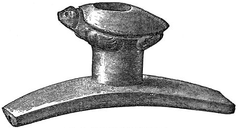
Fig. 14.—Pipe from Illinois mound, ½. (After Smithsonian Report.)
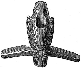
Fig. 15.—Pipe from Illinois mound, ½. (After Smithsonian Report.)
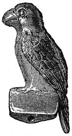
In additional support of this view, I call attention to the carved pipes found by members of the Davenport Academy of Natural Sciences, in the mounds near Davenport, Iowa, already referred to, which are represented on Plates IV and XXXIV of Vol. I of the Proceedings of that society, and to others obtained by Judge J. G. Henderson from some mounds near Naples, Illinois, and described in the Smithsonian Report for 1882. The latter are shown in Figs. 13, 14, and 15. The relation of these to the pipes found in the Ohio works by Squier and Davis is too apparent to be attributed to accident, and forces us to the conclusion that there was intercourse of some kind between the two peoples, and hence that the works of the two localities are relatively of the same age.
The mode of burial in one of the mounds near Naples is so suggestive in this connection that I quote here Judge Henderson's description:
The oval mound No. 1 was explored in April, 1881, by beginning a trench at the north end and carrying it to the original surface and through to the south end. Lateral trenches were opened at intervals, and from these and the main one a complete exploration was made by tunneling.
Near the center of the mound a single skeleton was found in a sitting position, and no objects were about it except a single sea-shell resting on the earth just over the head, and a number of the bone awls, already described, sticking in the sand around the skeleton. The individual had been seated upon the sand, these awls stuck around him in a circle 4 or 5 inches in the sand, and the work of carrying dirt begun.
When the mound had been elevated about 6 inches above the head the shell was laid on and the work continued.
The shell alluded to is a fine specimen of Busycon perversum, with the columella removed in order to form a drinking cup.
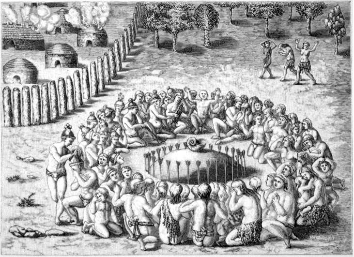
The particular point to which I call attention is this: In Plate XI, Part II of De Bry,[21] which is reproduced in the annexed Plate IV, is represented a very small mound, on the top of which is a large shell, and about the base a circle of arrows sticking in the ground. The artist, Le Moyne de Morgues, remarks, in reference to it, "Sometimes the deceased king of this province is buried with great solemnity, and his great cup from which he was accustomed to drink is placed on a tumulus with many arrows set about it." The tumulus in this case is evidently very small, and, as remarked by Dr. Brinton,[22] "scarcely rises to the dignity of a mound." Yet it will correspond in size with what the Naples mound was when the shell was placed upon it; nevertheless the latter, when completed, formed an oval tumulus 132 feet long, 98 feet wide, and 10 feet high.
It is therefore quite probable that Le Moyne figures the mound at the time it reached the point where the shell cup was to be deposited, when, in all likelihood, certain ceremonies were to be observed and a pause in the work occurred. Whether this suggestion be correct or not, the cut and the statement of Judge Henderson furnish some evidence in regard to the presence of these articles in the mounds, and point to the people by whom they were placed there.
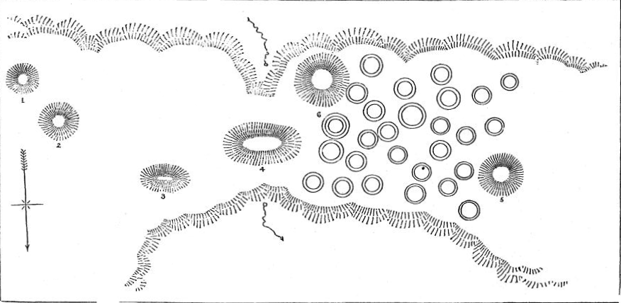
Fig. 16.—Group of mounds and hut-rings, Brown County, Illinois.
PL. IV. A MOUND, FROM DE BRY.
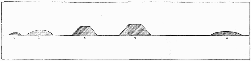
Colonel Norris opened a number of the ordinary small burial mounds found on the bluffs and higher grounds of Pike and Brown Counties, Illinois, which were found to be constructed in the usual method of this district; that is, with a layer of hard, mortar-like substance, or clay and ashes mixed, covering the skeletons. The positions of the skeletons varied, as we have seen is the case in other localities. The number of intrusive burials was unusually large here. In a number of cases where there were intrusive burials near the surface, no bones, or but the slightest fragments of the bones of the original burial, could be found, although there were sure indications that the mounds were built and had apparently been used for this purpose. These mounds also present evidence of the intrusion of an element from one people into the country of another. On the farm of Mr. Edward Welch, Brown County, Illinois, is the group of mounds shown in Fig. 16. This consists of conical and pyramidal mounds, and the small earthen rings designated house sites. The form of the larger mounds is shown in Fig. 17. Although standing on a bluff some 200 feet above the river bottom, it is evident at the first glance that these works belong to the southern type and were built by the people who erected those of the Cahokia group or farther south. No opportunity was allowed to investigate the burial mounds or house sites, but slight explorations made in the larger mounds sufficed to reveal the fire-beds so common in southern mounds, thus confirming the impression given by their form. It is probable that these mark the point of the extreme northern extension of the southern mound-building tribes. A colony, probably from the numerous and strong tribe located on Cahokia Creek around the giant Monk's mound, pushed its way thus far and formed a settlement, but, after contending for a time with the hostile tribes which pressed upon it from the north, was compelled to return towards the south.
Fig. 17.—Forms of larger mounds of the group shown in Fig. 16.
Passing to the northeastern portion of Missouri, which, as heretofore stated, we include in the North Mississippi or Illinois district, we find a material change in the character of the burial mounds, so marked, in fact, that it is very doubtful whether they should be embraced in the district named. Although differing in minor particulars, the custom of inclosing the remains of the dead in some kind of a receptacle of stone, over which was heaped the earth forming the mound, appears to have prevailed very generally.
The region has been but partially explored, yet it is probable the following examples will furnish illustrations of most of the types to be found in it.
From an article by Messrs. Hardy and Scheetz in the Smithsonian Report for 1881,[23] we learn the following particulars regarding the burial mounds of Ralls County:
Occasionally an isolated one is found, but almost invariably they are in groups of three to ten or more. They are usually placed along the crest of a ridge, but when in the bottoms or on a level bluff they are in direct lines or gentle curves. They are very numerous, being found in almost every bottom and on nearly every bluff. They are usually circular and from 2 to 12 feet high, and are composed wholly of earth, wholly of stone, or of the two combined. Where stone was used the plan seems to have been first to pave the natural surface with flat stones, in one or two thicknesses, for a foundation. In one case the stones were thrown together indiscriminately. Human remains are almost invariably found in them. The bones are generally very much decayed, though each bone is found almost entire except those of the head. This seems to have always rested on a stone, and to have been covered by one or more stones, so that it is always found in a crushed condition. In rare instances stone implements, pipes, etc., are found in the mounds. The remains found in tumuli wholly of stone are much more decayed than in those of mixed material.
One opened by the writers of the article is described by them as follows:
On the south side of it the bed stone had been formed into a shallow trough. On removing the flat stones which covered this, and which showed no action of fire, we found a bed of charcoal several inches thick, both animal and vegetable, and the limestone which composed it was burned completely through. Some fragments of a human femur were found in a calcined state. There were no indications of fire elsewhere in the mound, but there were the partial remains of several skeletons, lying in two layers, with stone and earth between them.
In another, examined by them, fragments of human bones were found so near the surface as to be reached by the plow; but deeper, on the north sides, were single skeletons laid at length east and west, and between them a mass of bones confused as though thrown in indiscriminately. The diameter of this mound was about 30 feet, height 2½ feet.
In section 24, township 55, range 7, is a small hill, known as "Wilson's Knob." Its crest, which is about 120 feet long, is completely covered with stone to the depth of several feet, the pile being about 20 feet wide. Examination brought to light the fact that this was originally a row of stone mounds or burial vaults, nine in number, circular in form, each from eight to nine feet in diameter (inner measure), and contiguous to one another. Judging from appearances it would seem that each had been of a conical or dome-like form. They were composed wholly of stone, and the remains found in them were almost wholly decomposed.
On another ridge the same parties found another row with four stone mounds similar to those described, except that the cists were square instead of circular, the sides of the latter being equal to the diameter of the former. In these only small fragments of bone could be found.
Although Messrs. Hardy and Scheetz evidently considered these stone structures as receptacles for the dead, and as erected for this purpose, yet it is possible they may have been intended for some other use.
The mounds of Pike County are chiefly of mixed material similar to those mentioned,[24] though some of them contain rectangular stone vaults. One of these vaults, measuring 4 by 5 feet, was found to contain the remains of eight skeletons. Another, a regular box-shaped cist of stone slabs, contained nothing save a few cranial bones very much decayed. Another of large size contained human remains with which were some arrow-heads, a vessel of clay, and a carved steatite pipe, having upon its front a figure-head.
I have given these particulars in order to show how closely they agree with the discoveries made by the Bureau assistant in this region, from whose notes I take the following description:
Fig. 18.—Group of mounds, Clarke County, Missouri.
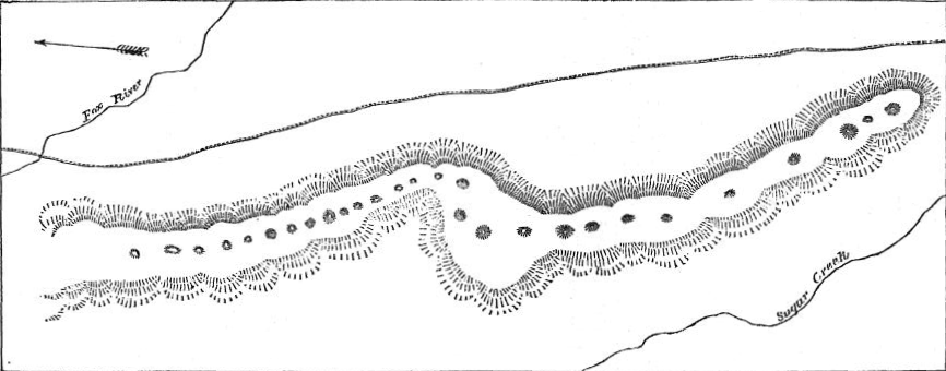
Between Fox River and Sugar Creek, in Clarke County, a sharp dividing ridge about 100 feet high extends in a northerly direction for nearly two miles from where these streams enter upon the open bottom of the Mississippi. Scattered irregularly along the crest of this ridge is a line of circular mounds shown in Fig. 18. These range in size from 15 to 50 feet in diameter and from 2 to 6 feet high, and are circular in form. In No. 3,[25] diameter 35 feet and height 5 feet, situated in the central portion, was found a stone coffin or cist 7 feet long and 2 feet wide, formed of slabs of sandstone in the usual manner. This was covered first with similar slabs and then the whole incased in a layer of rougher stones. Over this was a layer of hard earth, which was evidently in a plastic state when placed there, as it had run into and filled up the interstices. Above this was a foot or more of yellowish earth, similar to that forming the ridge. In the coffin was the skeleton of an adult, lying horizontally on the back, but too far gone to decay to admit of removal. No specimens of art of any kind were found with it.
No. 4, a trifle smaller than No. 3, was opened by running a trench from the eastern margin. For a distance of 15 or 16 feet nothing was encountered except the earth, with which it appeared to be covered to the depth of 2 feet. Here was found a layer of rough stones covering a mass of charcoal and ashes with bones intermixed. In fact the indications leave the impression that one or more persons (or their bones) had been burned in a fire on the natural surface of the earth near the center of the mound, the coals and brands of which were then covered with rough stones thrown in, without any system, to the depth of 3 feet, over a space 10 or 12 feet in diameter, and then covered with earth. Only fragments of charred human bones, pieces of rude pottery, and stone chips were found commingled with the charcoal and ashes.
Another group on the farm of Mr. J. N. Boulware, near the line between Clarke and Lewis counties, was examined by the same party. This group, which is situated on a bench or terrace from 20 to 40 feet above the Mississippi bottoms, consists of some 55 or 60 ordinary circular mounds of comparatively small size.
In one of these, 45 feet in diameter and 5 feet high, were found, near the top, the fragments of a human skeleton much decayed, and broken pottery, encircled by a row of flat stones set up edgewise and covered with others of a similar character. Below these was a layer of very hard light-colored earth, mixed throughout with fragments of charred human bones and pottery, charcoal and stone chips.
Another, about 60 feet in diameter, was found to consist (except the top layer of soil, about 1 foot thick) of hard, dried "mortar" (apparently clay and ashes mixed), in which fragments of charred human bones, small rounded pieces of pottery, and stone scrapers were mingled with charcoal and ashes.
"As all the mounds opened here," remarks the assistant, "presented this somewhat singular feature, I made a very careful examination of this mortar-like substance. I found that there were differences between different portions of the same mound sufficiently marked to trace the separate masses. This would indicate that the mounds were built by successive deposits of mortar thus mixed with charred bones, and not in strata but in masses."