Front matter (continued 5)
Reading edition
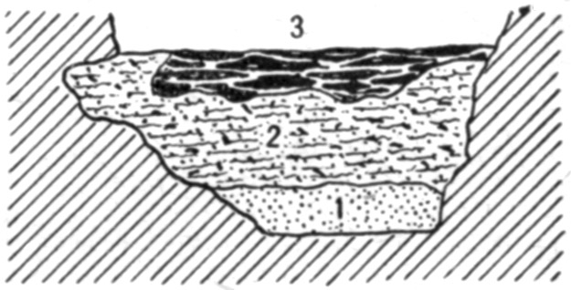
Fig. 28.—Cross section of Fort Deposit Cave at 30 feet.ToList
At 38 feet the yellow earth had risen until it was within 3 feet of the top of the entire overlying deposit. The latter contained little of the dark earth, being mostly composed of ashes and burned earth, some of which resulted from fires made on the spot, but the greater part being thrown from other points. The rise of the yellow earth, consequently, is more rapid than the rise of the material covering it.
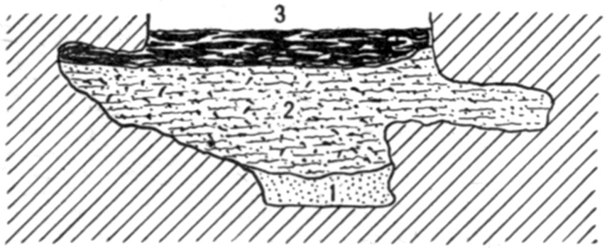
Fig. 29.—Cross section of Fort Deposit Cave at 35½ feet.ToList
At 40 feet there was a dip in the yellow earth, extending for 4 or 5 feet and descending 2 feet at the deepest point. This may be due to drainage at a lower level.
At 47½ feet a pocket of the dark earth extended a few inches into the underlying yellow earth. A hole seems to have been dug into the latter. There was no more of foreign material in this hole than elsewhere in the dark earth above and around it. It is shown in figure 30.
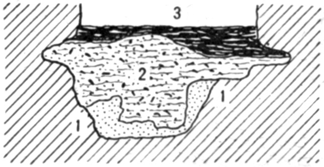
Fig. 30.—Cross section of Fort Deposit Cave at 47½ feet.ToList
The amount of shells, pottery, etc., had been decreasing for several feet before this point was reached; indeed, from 40 feet onward there was very little of it—enough, however, to show that all the dark earth had been disturbed and thoroughly mixed. The fire beds, too, while holding their depth of about a foot, contained more earth between the successive layers of ashes, showing as great age, probably, as those nearer the entrance, but less continuous occupation. This condition prevailed to about 60 feet from the entrance, at which point the yellow earth, now mixed with sand and gravel, was only 3 feet below the surface of the floor. The appearance of this line is sketched in figure 31.
At 62 feet there was a dip in the yellow earth, extending to 67 feet and 2 feet deep at its lowest point; it then rose to the usual level.
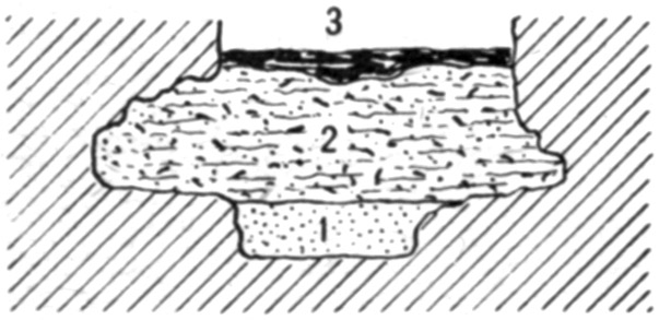
Fig. 31.—Cross section of Fort Deposit Cave at 60 feet.ToList
At 70 feet ashes appeared in greater quantities; at 73 feet the dark earth was only a foot thick, the ashes and burned earth being 2 feet thick and apparently all dumped, as there was no definite arrangement of the various parts. (See fig. 32.) A small perforated disk and a double-pointed bone needle were found here.
The fire beds now began to thin out rapidly, the dark earth also diminishing in quantity, until at 80 feet, from which point the entrance was no longer visible owing to curvature of the walls, there was only 5 or 6 inches of them in all, resting directly on the yellow earth, which contained much more clay than farther toward the front. The walls began to diverge here, forming a room whose greatest width was 11 feet 6 inches at 95 feet. At 100 feet a reverse curve brought the cavern on a course parallel to that which it had held up to 60 feet.
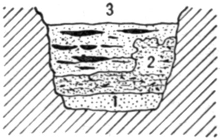
Fig. 32.—Cross section of Fort Deposit Cave at 70 feet.ToList
At 90 feet there was evidence of fire at one side, the ashes and burned earth being 5 inches thick at the wall, and thinning out to a feather edge within 4 feet. This was the last fireplace discovered which may not with certainty be attributed to white men. The yellow earth, presenting no evidence of having been disturbed since originally deposited, reached from the superficial layer of loose dry earth to the bottom of the trench, a depth of 4 feet 8 inches. Below this point the walls were less than 4 feet apart, and the space filled with gravel, as shown in figure 33. This gravel had exactly the appearance of that in gullies on the hills outside, and plainly dates back to the period at which the cave was formed. The stream which aided in the erosion, or which flowed through from some sink hole or other outside opening, carried this gravel into the crevice. Consequently, even if the space between the walls had been ample for dwelling purposes, an attempt to live here when the gravel was being carried in would result in the intending settler having his effects washed out into the river.
At 93 feet the side walls confining the yellow clay narrowed to a little less than 5 feet apart. The upper portion of the one to the left has been eroded into a recess or cavity, forming the chamber above mentioned. The earth on the rock floor in this recess is nowhere more than a foot deep. A section is presented in figure 34.
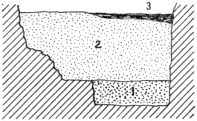
Fig. 33.—Cross section of Fort Deposit Cave at 90 feet.ToList
At 100 feet the room came to an end. The space between the walls was 7½ feet at the floor level and 4 feet at a depth of 4 feet. At 105 feet the nearly vertical walls were only 5 feet apart on the floor; at 112 feet the space increased to 7 feet. A section showed about a foot of loose earth mixed with ashes; 3 feet of yellow clayey earth, rather compact; then gravel and sand. The latter was dug into for a foot, at which level the walls were converging and it was useless to go any deeper. Enough was done, however, to verify the supposition that this stratum was due to the action of running water seeking its outlet at the mouth of the cave.
At 103 feet, at the bottom of the yellow clay and on top of the gravel, was a chalcedony pebble about 2½ inches in diameter. The material is foreign to this locality. It had plainly been used as a hammer stone, and is the only object of human origin found anywhere below the dark earth. There was not the slightest evidence of any disturbance of the clay in which it rested.
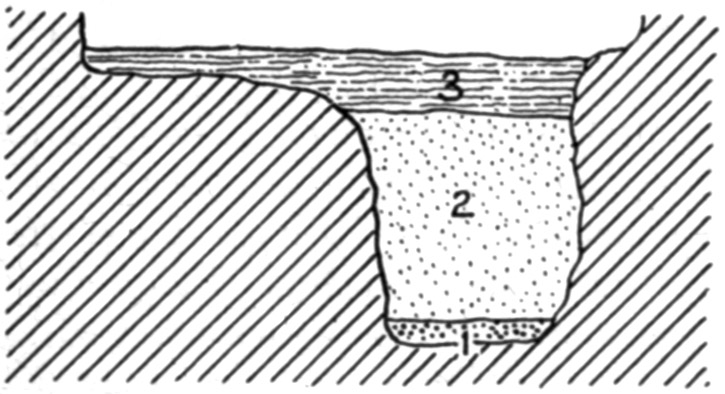
Fig. 34.—Cross section of Fort Deposit Cave at 93 feet.ToList
At 120 feet the side walls were only 5 feet apart. At 125 feet they again diverged slightly, and a recess on the left forms a chamber 12 feet across. At 150 feet they had drawn in to 8 feet at the widest interval. A section showed loose dry earth, some of it cemented by drip from the roof until about as hard as lump chalk; then compact clayey earth, also with travertine in small lumps; below this the gravel and sand. The latter, at this point, seems to have been deposited in the last stages of the formation of the cave. Occasionally, along here, a small patch appeared that seemed to be ashes; but none of it was more than 6 inches below the top of the ground, and the substance may not have been ashes at all, but the fine white limestone dust that wears off from the stone. There was nothing in the trench, at any depth, after the chalcedony pebble, that could possibly be due to human intervention, except these small patches of ashes, if ashes they are.
At 165 feet from the entrance the cave made its fourth turn and expanded into a chamber about 15 feet wide. Along the sides of this and in the various crevices opening from it were great quantities of clean ashes, plainly enough thrown there from fires made in the central part. The gravel came to within 3 to 5 feet of the top, being quite irregular. On the gravel was dry clay, seamed and fissured in all directions so that it fell out under the pick in clods like angular pebbles from an inch to 3 or 4 inches across. This was clearly the result of muddy water settling in a hole and thoroughly evaporating. There was also some travertine in small lumps here and there through the clay, and above it was a mass fully 2 feet thick at one side of the trench but running out before it reached the other side. It was porous, almost spongy, and seemed to be the lime dust from the roof and sides cemented by dripping water. Above all this, so far as the trench extended toward the sides of the cave, was an inch to 4 inches of loose, dry, dark earth, which on the left dipped down to the clay, thus replacing the travertine.
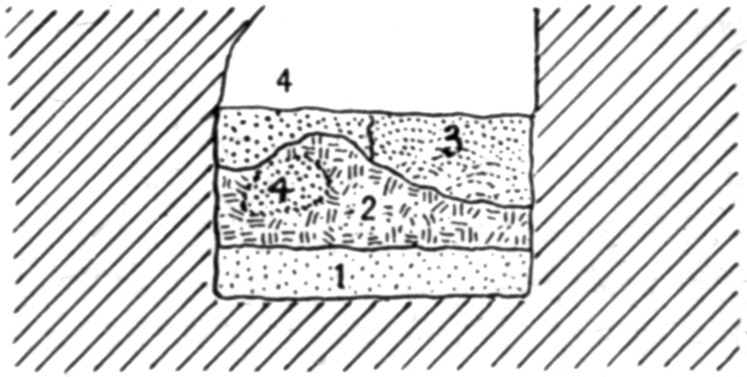
Fig. 35.—Cross section of Fort Deposit Cave at 175 feet.ToList
At 175 feet the gravel had leveled down and was more or less mixed with clay and sand. Above this was another "mudhole deposit" of clay which had thoroughly dried out and become checked and cracked in all directions. On the right this was covered with travertine slightly mixed with earth and clay; on the left, above it and also at one place within it, was a coarse gritty earth fallen from the roof but not converted into a compact travertine. The section appears in figure 35. At 180 feet the trench was carried to a depth of 6 feet. This exposed a fine clay and sand, or silt, like that deposited in the eddies of streams. Above this was another deposit of "mudhole" material which had thoroughly dried out, checked and cracked in all directions so that it formed angular masses of various sizes, and had then become wet again so that it was now soft and sticky. To the left of this, on the silt also, was a small amount of the gravel. It had the appearance common to a bank of such material on the side of a little stream which has undermined and carried away part of it. Clearly, these three formations were of an age that witnessed the erosion of the cave. Next above them was a stratum of loose dark earth similar to that noticed in the front part of the cavern; but here were found no traces whatever of man's presence. Into the right side of this stratum projected the wedge-like edge of a mass of travertine, which was not traced to a termination. Over all lay a deposit 3 or 4 inches thick of dark, nearly black earth, mixed with ashes. This is quite modern. The section appears in figure 36.
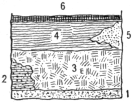
Fig. 36.—Cross section of Fort Deposit Cave at 180 feet.ToList
During the Civil War the cave was continuously resorted to by deserters, refugees, moonshiners, fugitives, and "food for powder, dodging the conscript." All these sought shelter in this chamber and behind it, in order that their fires might not be visible from the river. The piles of ashes in the crevices and corners were thrown there by these hiders-out, to get them out of the way. Similar but smaller piles of ashes are to be seen all along as far as the spring, 200 yards from the entrance.
The presence of pottery of a type common to this region in fields and shell heaps, and of maize, denotes that all the fire beds, etc., are the results of habitation by the modern Indian. Where these ceased nothing else was found. In or below the yellow earth, clay, or gravel, nothing can be found; for until these were laid down and the stream of the cave had sought another outlet, there was no dry place in which to live.
It may be worth recording that a dead mulberry tree stood about 20 feet in front of the entrance to the cave. Under it was a narrow crevice filled with earth, but all around it was bare rock. A root, larger than the tree, grew into the cave and followed along one side wall as if fastened there for a distance of some 60 feet. Here the earth floor of the cave came high enough to cover it. This root was exposed for 160 feet in the trench, or 180 feet from the tree; at this point it was 3 inches in diameter and turned aside into a crevice. As the root could not have grown in the open air, it furnished proof that much deposited material has been carried out of the front portion of the cavern and away from the ledge since this tree was a sprout.
III. EXPLORATIONS ALONG THE MISSOURI RIVER BLUFFS IN KANSAS AND NEBRASKAToC
VICINITY OF WHITE CLOUD, KANSAS
About 4 miles southeast of White Cloud, Kansas, is the "Taylor Mound," from which Mark E. Zimmerman and William Park took 56 skeletons, or portions of skeletons, in a space not more than 6 by 20 feet. This was clearly an intrusive communal burial of skeletons carried from some other point and interred in the mound which owed its origin to persons who had piled it up at some previous time. The bones, which were not arranged in any order, were 30 inches beneath the present surface of the mound, but this does not mean they were no deeper originally, as the mound has been plowed for many years and is in a situation where it will easily wear down when cultivated.
A few feet away, at a depth of 7 feet, other bones, or fragments of bones, were found in a mass of burned clay. A cremation had taken place at some point away from the mound, and the resultant burned earth, with so much of the bone matter as was not destroyed by the fire, was carried here and buried. The depth in this instance is not significant; the earth is loose and very easily dug; besides, the grave pit was near the margin of the mound and earth had washed down over it from above.
Some stones, carried from neighboring ravines, have been exposed by the wear due to erosion from natural causes and from cultivation. The main portion of the structure is still intact, and it is probable that no deposits belonging to it at the time of its construction have been unearthed. A systematic exploration, showing the original construction as well as the alterations resulting from later burials, is much to be desired.
While this is the largest mound in the vicinity, and is claimed to be the largest mound in Kansas, it is not different except in size from many others within a few miles. All of them are made of the same earth as that which lies around them—a light, sandy loess which is easily removed with a shovel, requiring no picking or other loosening. In fact, it is almost as easy to dig as loose sand would be. Sometimes there are flat limestones in or around the graves; similar slabs are found not far away in the ravines.
Not far from this mound is a large lodge site, one of the so-called "buffalo wallows" as they are commonly known. These are the ruins of aboriginal houses. The general construction is the same, the only practical difference being that some are square in outline, others round. This difference is not always apparent prior to the excavation. In the making, a pit was dug, square or round as desired, and the earth thrown out on every side. Posts were then set around the margin of the excavation, and the house built in the same manner as those with which we are familiar from accounts of early travelers. Many of them have been examined by Zimmerman and Park, who found masses of hard-burned earth in which are cavities and depressions due to the burning of straw, grass, twigs, and poles, used in the construction of the houses. This results from the destruction of the houses by fire. Sometimes the floor has a layer of this burned material which is evidently due to the falling in of the roof. Most of these are on the hilltops, but some of them are on narrow ridges leading from the high land to the creek or river bottoms. In the latter event there is always a village site on the low ground bordering the stream. The relics gathered up on these village sites are in no wise different from those found when the lodge sites are excavated; and also are of the same character as those picked up on what are no doubt modern village sites in the vicinity. This fact militates against the idea that the lodge sites are extremely ancient.
IOWA POINT
On a low hill, cut off on every side by steep ravines, is a small mound containing a cist grave. The bottom of this, which was dug slightly below the natural surface, was covered with a pavement of limestone slabs. The grave was roughly oval or triangular in outline, measuring about 7 by 9 feet. Around it was a wall of similar stones, set in contact and sloping outward at an angle of about 40 degrees from the vertical. There was nothing whatever in this grave.
At the edge of the mound was a box grave 5½ by 2½ by 2½ feet, the longer axis on a radial line. It was made of small flat stones built up like a wall, the only grave of which I could learn that had any resemblance to the vault graves farther down the Missouri. In the grave were two skulls and some other bones, all bunched in the northern end.
NEAR THE MOUTH OF THE NEMAHA RIVER
Lewis and Clark, in their journal, mention that when camped near the mouth of the Nemaha, one or both of them went to an Indian village about 2 miles up the stream. He, or they, climbed a low ridge near the river and stood on a mound which commanded a fine view of the surrounding country. There is a dispute as to the site of this mound; but the journal plainly says it was on the lower (east) side of a little creek which comes in here. Two miles farther up is a larger mound on higher ground which is generally supposed to be the one meant by the explorer; but this is on the other side of the creek and at some distance from the Pawnee village which was located near the mouth of the creek, on the lower side. The ground where this village stood is covered over a space of several acres with the ordinary débris of an Indian settlement; and it is significant that all the relics found are so similar to those which are called "ancient" when found in the lodge sites, that no one could determine from inspection which kind came from which place. Unless it may exist in the markings in the pottery, no distinction can be made between these specimens and similar ones from other localities.
The Pawnees lived here until 1837, when the Iowas and Otoes made a sortie upon the unsuspecting inhabitants and killed all of them they could overcome. Two women of the Iowa tribe who were living on the reservation in 1914 remember seeing dead bodies lying around wherever the invaders could find and kill a resident.
A short distance below the explorers carved their names on a rock which projected into the stream. Accounts as to this spot differ; it is generally stated that in making a road around here, the rock containing the names was blasted away; but a man in the neighborhood who claims to know the exact spot says the blasting did not extend quite so far and that the names are covered by a mass of earth and rock which slid from the bluff many years ago. If this be true, a thrill awaits the man who finds the names some centuries from now, when the river has washed away all this accumulated material.
VICINITY OF TROY, KANSAS
Near the mouth of Wolf River is a village site on which Dr. R.S. Dinsmore, of Troy, has counted 125 tipi sites. Relics are very abundant here, especially the small chert "thumb-scrapers," which outnumber all other specimens.
MOUTH OF MOSQUITO CREEK
Four miles east of Troy, on a ridge so steep that its top is inaccessible from either side, and so narrow that a wagon would make a track on each slope, is a little mound worn down until its true nature would not be suspected. Dr. Dinsmore was on this ridge one day and noticed a flat limestone rock. Knowing that it had no place in the loess, he began digging to ascertain the reason for it being there. At a depth of a few inches he found bones, and soon unearthed a number of skulls, with only his hands or a stick. Coming back later with tools, he found, in all, 56 skulls. Afterwards he found others, and persons in the neighborhood have exhumed many more. The deposit represents a communal burial, from a village which probably stood on the level creek bottom not far away. A few skeletons showed an attempt at orderly arrangement. These were probably of individuals who had not been dead long at the time of the general burial. Most of the bones, however, skulls and others, were piled in the smallest possible area, as if gathered up in sacks or baskets from previous burials and carried here for reinterment. The soil is so loose as to be easily dug with the hands, like sand; but at the same time so fine and close packed as to shed water almost like a roof. Owing to the steep slope at every point, except toward the summit of the ridge, there must be some erosion, and consequently the age of the burials can not be great. Yet, the same conditions prevail in other places where a great antiquity is claimed for the remains. Frost necessarily disintegrates the soil to some extent; the wind or rain carries away the loosened portions; and this process is continuous. The shape of the mound shows that when the burials were made the ridge was essentially identical in form with its present aspect. The bones also are comparatively fresh in appearance, and it may be considered certain that they can not date back many generations.
On the top of a hill rising from the opposite side of Mosquito Creek Dr. Dinsmore found a low mound, which, like that just described, would not have been suspected as such but for a stone projecting from the surface. Under this stone, with 8 inches of earth intervening, was a skull so completely mineralized that it appears to be carved from a block of limestone. No other portions of the body to which it belonged remained, though traces in the surrounding earth showed that at least the larger bones and perhaps the entire skeleton had been deposited. Bones in other parts of the mound were in their natural condition; that is, they were not altered from their ordinary appearance, although only in fragments. It is remarkable that this entire cranium should thus change while all the other bones, even the jaw, had disappeared. The description of this find is from Dr. Dinsmore, who has the skull in his office. Possibly he may be in error in stating that traces were found of other bones belonging with it. These may have belonged to another individual. The soil is ordinary sandy loess, containing lime but not in such quantity as to account for this alteration. Perhaps the skull may be from an older burial somewhere, the petrifaction having taken place before it was buried here.
RULO, NEBRASKA
Particular attention was paid to conditions a mile north of Rulo, where it is reported that human skeletons were found in the Kansan drift. It was not the intention of the discoverer to have it understood that these remains were in undisturbed drift, but such is the impression that has gained credence.
At the settlement of the country by whites the road constructed across a ravine here, on the section line nearest the river about three-eighths of a mile away, followed the natural contour and the crossing was made without difficulty. Since then a deep washout has worked its way to some distance above this point, making a long bridge necessary. From the head of the washout to the Missouri River the banks are vertical, or nearly so, on each side of the little stream. It was in the bank on the south side that the bones were found. It is stated they were 7 feet under the surface; if so there must have been a mound above them, for the lowest excavation does not reach over 5 feet below the present level of the ground, and at that extends slightly below the bottom of the grave.
Within 40 years the Missouri River, which is now more than a mile away toward the Missouri shore, flowed at the foot of a slight bluff terminating the slope from the high land toward the west; there was formerly a steamboat landing on the upper side of the ravine. On the lower side is a triangular area of about an acre, bounded by the bluff, the river bank, and the ravine. This was an excellent location for an Indian village or camp. A narrow level strip extends from the mouth of the ravine to a point near the bridge, some distance above where the remains were found. It is quite clear that the skeletons were the remains of individuals who had died at the camp on the river's bank and had been carried here for burial. This may have occurred within the last hundred years or in fact at any time while the Indians were still living in this vicinity.
The flood level of the Missouri is not more than 15 feet lower than the level space along the sides of the ravine. The little intermittent stream has cut down this depth through a deposit which is composed of river sediment, wash from the hills on each side, and material carried from higher levels by the brook itself in rainy seasons. At only one point is there a real glacial deposit, and this does not extend for more than 50 feet horizontally, and does not reach to the top of the bank. It is at some distance from the graves, and may be due to a lobe of the ice or to an iceberg. However formed or deposited here it has no relation whatever to the skeletons. In a sense, the material in which they were buried is "Kansan drift"; but it is drift which has been redistributed and has come into its present position within a few centuries at the most.
NEAR HOWE, NEBRASKA
Mr. Sam P. Hughes, who lives near Howe, has done considerable excavating in that vicinity. He is an intelligent man and an ardent student, but his ideas in regard to the age of his discoveries need much revision downward. His chief work has been done north of Howe at a place 9 miles from the nearest point on the Missouri River. Here is a small level area at the end of a ridge sloping away in every direction except at the narrow isthmus connecting it with the fields beyond, which are at a level only slightly higher. Thus there is no chance for any accumulation from the adjacent surface. On this ridge are a few lodge sites which Hughes has excavated. In every respect they are similar to lodge sites reported from other localities in this region. The walls, the depression, the floor, the fireplace, are all the same. The depressions are filled with earth to a depth of 18 to 22 inches above the level of the old floor; and Hughes reports that wherever he has dug on this ridge he has found flint chips, charcoal, fragments of pottery, and scraps of bone to about the same depth. Next below the soil is the Kansan glacial drift; but the assertion that objects found at this depth are of the same age as the drift is not necessarily or even presumably correct.
PERU, NEBRASKA
On various hills in the vicinity of Peru are lodge sites, some of them circular, some rectangular, some with straight sides and rounded corners. Most of them have been dug in at random; in every case after a certain depth of accumulated earth and trash is passed through, there is a layer of clay which formed the roof, and beneath this the hard earth floor with fireplace usually in the center but sometimes a little toward one side.
PAPILLION, NEBRASKA
At the time of my visit, Dr. Frederick H. Sterns, of the Peabody Museum, was working near here. He described himself as "the man who is extremely anxious to find a glacial or other very ancient man, but so far has not succeeded in getting track of him." Dr. Sterns did not claim a period antedating the Indian for anything he had then unearthed—meaning the known Indian tribes.
VICINITY OF OMAHA, NEBRASKA
To the southward of Omaha are many lodge sites of varying depths and diameters. The deepest one reported had a depth of 9 feet below the surrounding surface, and at the bottom of this was a pit (or "cache," as they are locally known) with an additional depth of 4 feet, or 13 feet of excavation in all. This was near the so-called "cannibal house," where 14 human frontal bones were found under conditions which indicate they had belonged to individuals who were eaten by other inmates of the lodge.
A short distance from these sites, across a ravine, is a bare, narrow ridge, very steep on each side, so that erosion would readily act. On the sloping summit of this are three small mounds which cover communal burials. From one of these, the one farthest from the summit of the hill, more than 80 skulls were taken and boys in the neighborhood have since taken many more. They are all of the ordinary Indian type, and can not have been buried more than a few generations ago; but this fact has not prevented an age of "twenty thousand years" being assigned to them. There is absolutely no reason for fixing this or any other date. There is nothing whatever to indicate the age, but 200 years would probably not be far from the mark, because erosion has been slight since the mounds were piled up.
LONG'S HILL
This ridge has attained some notoriety as the site of Gilder's discovery of the "Nebraska Man." The claim is made that human bones were found at a depth of 14 feet in absolutely undisturbed loess. The hill is a narrow ridge, facing the river on one side and a deep ravine on the other. It is somewhat winding in its course and is connected with the more level land in the rear at about half a mile from its end. A wagon road up the point, from the river bottom to the hilltop, shows undisturbed loess the entire distance. There is no possibility of accumulation by wash or in any other manner except decaying vegetation on any part of this ridge.
Along the crest are several small mounds. Some of these, as shown by excavation, cover graves, and the presumption is that all of them mark burial places.
It is needless to make any résumé of Gilder's report, as it is so well known, further than to say that he found burials and fragmentary human bones at various levels from 2½ to 14 feet. At 4½ feet were burned bones lying upon burned earth and mingled with it. This layer, burned hard as a brick, served to prevent water from penetrating the earth immediately below; and it is in this earth that the deepest remains were found.
There are three ways, and only three, in which they could get there:
1. They were washed in when the loess was deposited, as claimed by the discoverers and by some of the Nebraska geologists.
In support of this view is the assertion that the bones were water-worn. On this point I can not venture any opinion, as I have not seen them. But I have found bones in mounds and in other situations where such wear was impossible and yet having the smoothed and rounded appearance characteristic of such action by water or the elements.
In support of this theory, too, is the positive statement of Nebraska geologists who have had ample opportunity to become familiar with loess in all its phases; and they claim the deposit is the original and has not been disturbed.
It is necessary for these advocates, however, to tell where such fragments of bones could have come from and how they could have been washed to the place where found, when all these bluffs were covered with water, as they had to be at that time.
2. The bones could have been carried by rodents into their burrows or runways, as Hrdli[vc]ka suggests. In this case the material in contact with the bones would have to be somewhat different in appearance and consistency from that which lay a few inches, or perhaps only an inch, away. The Nebraska men say this was not the case.
3. There may have been an excavation or pit similar to that in which the Hurons buried their dead. But as no such burial pits have been discovered in this part of the country, this supposition must be excluded.
A corollary to the last is that a deep but small pit similar to the so-called "caches" in the lodge sites may have been dug here and the bones thrown in. There is no indication whatever of a lodge site or any other form of habitation at this point, but I have found such pits in the vicinity of Indian houses, though not just on their site. The deepest one I have ever found was 10½ feet and less than 6 feet in diameter. There would be no difficulty in digging into this loose material as far as an excavator cared to go, until he had reached a depth at which he could no longer get the loosened earth to the surface of the ground. As mentioned above, a pit south of Omaha had a depth of 13 feet, or only 1 foot less than is claimed for this—or rather for the greatest depth at which it is claimed fragments of bone were found.
The objection made to this theory is that the earth thrown out of the hole was unmixed, presenting throughout the appearance and consistency of loess as it occurs where exposed in ravines or on slopes in the vicinity. It is contended that if any previous excavation had been made here and filled up afterwards the mixed earth would be easily distinguished from that which was not removed, and that the line of demarcation would be easily discernible.
As a rule, this is true; but when dry loose earth of homogeneous consistency is thrown out of a pit and then thrown in again without becoming mixed with any other it is sometimes impossible to distinguish it at a later excavation. This is especially true of earth free from vegetable matter, as ordinary sand; or composed largely of vegetable mold, as the soil in overflow lands which have built up mainly from floods carrying uniform soil sediment. The line of demarcation between the dug and the undug earth in such conditions may become indistinguishable except when a vertical face is made which shall show a clear section of both in contact.
It is now too late to learn anything about the matter from the site itself. So many persons have been digging that it would be impossible to know when the limit is reached between the original excavation—assuming it to have been made—when the bodies were interred, and that resulting from the modern researches. The question of age hinges upon the appearance of the earth in which the bones were found; and the only way in which we can now learn anything about it is to trench across the hill at some of the other burial places, in the hope of finding bones at a similar level, and determining from the conditions in which these are found how they came there.
It is beyond question that any soil, humus, or other discolored matter thrown into an excavation with ordinary soil or subsoil will be apparent for an indefinite time afterwards. But on some of these high points and ridges there is even now not a trace of soil. Frost and wind have worn bare spots where nothing grows or has grown for a long time. As this region was a prairie devoid of even brush when the whites settled here, it is evident that such slight protection as grass or weeds afford would not be sufficient to hold the earth in place in winter, and when the ground is once swept bare such humble forms of growth may not get a foothold in future. Anyone who has studied surface geology knows these facts.
So at present the whole question of the age of these bones resolves itself into a statement of one party that they were found in undisturbed loess, as reported; and of the inability of another party to show that there may have been an error of observation or a mistaken interpretation.
There need be no such doubt in regard to the age of the mounds or the lodge sites. It would not take many centuries for mounds upon these sharp, exposed ridges to be entirely washed away, in spite of the fact that the fine loess is almost impermeable. Rain may not reduce them to an appreciable extent, but frost and wind will gradually wear them down. As to the lodge sites, their similarity to modern Indian houses is so pronounced that we are fully justified in attributing them to the same degree of culture as that of the Indians of a century ago. The only point of difference is that the latter dwellings have not such deep excavations, but the incursion of war-like tribes, or the restlessness that impels a primitive community to be frequently on the move, seems a simpler explanation of the difference than to suppose that identical types are separated by a great period of time.
Three points must be taken into consideration in fixing a definite age for these remains:
1. The relics found in and around the lodge sites, except for the markings on some of the pottery, are in no wise different from those picked up on the sites of villages which were occupied when Lewis and Clark came through here.
2. Fairly solid bones of animals, and occasionally of humans, are found in the bottoms of the lodge sites, even where these are damp most of the year. In the pits, where such remains are preserved by ashes, this would not mean much; but where they are found in clayey earth it is evident that "thousands of years" is a meaningless term to apply to them.
3. Persons who claim these "thousands of years" for pretty much everything they find in the ground must explain why it is that while the bones and implements of these assumed "ancients" are found in such quantities and in such good preservation, those of later Indians should have entirely disappeared.
The only tenable theory of age is the amount of accumulation in the depressions of the lodge sites. Above the clay which formed the roof, and is next to the floor now, is a depth of material sometimes (it is said) as much as 20 or even 22 inches of mingled silt, decayed vegetation, and soil from the surrounding wall. It is used as an argument of age that as these sites are on hilltops where there can be no inwash, this depth must indicate a very remote period for their construction. But a large amount of the earth thrown out into the surrounding ring or wall will find its way back into the depression. The water will stand in them a good part of the year, and the soil remain damp even in prolonged drought; vegetation is thus more luxuriant than on the outside, and its decay will fill up rather rapidly. In addition, much sand blows from the prairies as well as from the bottom lands, and whatever finds its way into the pit will stay there; it will not blow away again as it would in open ground. The weeds, also, will catch and retain much of this dust which would pass over a dry surface. Consequently the allowance of an inch in a century, which is the most that advocates of great age will allow for accumulation, is much too small.
The topography of the region was essentially the same when these remains were constructed as it is now. The hills and valleys were as they now exist; the erosion has been very slight as compared with what has taken place since the loess was brought above the water, to which it owes its origin. This statement is fully proven by the position of the mounds and lodge sites. Any estimate of age must be only a guess at the best, but it is a safe guess that no earthwork, mound, lodge site, or human bone along this part of the Missouri River has been here as long as 10 centuries.
IV. ABORIGINAL HOUSE MOUNDSToC
The small, low, flattened mounds of the lower Mississippi Valley are a problem to archeologists. They have been studied principally near the Mississippi River, in Arkansas and Missouri, and for many years it was thought that in the latter State they are confined entirely to the southeastern portion. Recently they have been found much farther to the north and the west than they were supposed to exist.
A group, rather limited as to number and to the area covered, is at the head of a narrow valley trending northward from Granite Mountain in Iron County.
"Near Iron Mountain, in St. François County, more than 500 of these small mounds, arranged in parallel rows following the direction of the watercourses, were counted within a radius of 3 miles."[1]
The next group known north of this is on the right bank of Plattin Creek in Jefferson County, about 12 miles from the Mississippi.
"A group of some 50 similar mounds is situated on the right bank of the Meramec, about 6 miles above its mouth, in Jefferson County."[2]
The most northern group so far observed is near Ferguson in St. Louis County, Missouri, where 46 are located on a narrow ridge which has the same general elevation as the table-land. The ridge extends around the head of a ravine, and the mounds are placed along its crest or on the gentle slopes near the top. There are 10 or 12 at the southern edge of Ferguson, on an overflow bottom bordering a small creek.
Toward the west from the swamp region a small group is in a broad valley near Alton in Oregon County, which borders on Arkansas. They are scattered along a gentle slope which has a little stream at the foot.
In Dent County four groups are known. One is on the infirmary farm south of the town of Salem. Most of these are but slightly changed from their natural condition. Another group is 6 miles east of Salem. These also are largely intact. A third is on the road from Salem to Short Bend. The fourth is at the edge of Salem, on the Rolla road.
"On the high plateau of Dallas County, north of the Niangua ... within an area smaller than 10 square miles, 860 were counted."[3]
Three groups are well marked in Phelps County. A mile east of Rolla they begin at the line of the Frisco Railway and extend southward in a shallow valley or "draw." Some are on the overflow flat bordering the little stream, but most of them are on the slopes to either side.
South of Dillon they extend for a mile in a slight depression.
Beginning at the Soldier's Home in St. James, the largest number yet found out of the swamp region lie for 2½ miles on both sides of a small creek running eastward north of the Frisco Railway. These reach from low land subject to overflow to an elevation of fully 50 feet up the hillsides.
Several groups occur in Pulaski County. Four miles southwest of Big Piney post office, near the site of what is known as "The Ranch House," is a little wet-weather stream along both banks of which are probably a hundred of these structures. Farther up this stream are two other groups, the three including a distance of about 4 miles in length between their outer limits. West of these and south of Bloodland is a fourth group belonging with these.
In the level bottom between Big Piney River and the branch flowing from the Miller Spring 2 miles from Big Piney post office a number of these mounds formerly existed; and on the opposite side of the Big Piney, in an extensive bottom, were many of them. All these have now disappeared under cultivation.
On the outer bend of the Devil's Elbow, on Big Piney 3 miles above its mouth, some of these mounds stood. They are described as being from 2 to 3 feet high; the number was not stated, but there is not room for many in the narrow strip where they were located.
In the extreme western part of Morgan County, at Stover, is a group scattered over an area at least half a mile across in any direction. The distance between the mounds varies from 25 to 150 feet. They are mostly on gentle slopes, though some are on the crest of the ridges. Many of these are well preserved, some of them having never been under cultivation.
In Osage County there are more than a hundred at the eastern edge of Rich Fountain. They are in low flat ground which is muddy or even boggy in wet weather.
It will be noticed that all those from Alton westward and north-westward are in line with the route from southeastern Missouri to the plains of Kansas and Nebraska.
Practically, however, the northern limit of this type, in great numbers, is in St. François County, near Farmington. From here they extend almost continuously into Louisiana and Texas.
In nearly every part of southern Missouri east of the Iron Mountain Railway they occur in closely connected groups, reaching sometimes for miles except where the continuity is broken by a slough or other unfavorable condition. They are found everywhere—on high, well-drained levels; on sloping ground, sometimes so steep that it may well be called a hillside; in low "crawfish land"; in swamps where, in the driest weather, even after a prolonged drought, they can be reached only by wading through water or muck. The last, however, may have been more easily accessible when built, their present condition being due to the general subsidence of this region during the earthquake period of 1811. The existing sloughs and sluggish bayous are the widenings and extensions of streams which at the time these mounds were constructed were no doubt bordered by banks above ordinary overflow and readily reached by canoes. Manifestly the country was well populated, and therefore presumably practically timberless; consequently the flood water would rapidly pass away and the streams not be choked by drift and other débris as is the case at present.
Various theories, most of them advanced by persons who are but slightly, if at all, familiar with the country, have been propounded to account for mounds of this character. Their vast number has led some writers to believe that they can not be artificial but must be due to natural phenomena; as, for instance, that these, as indeed all mounds, were piled up by floods, Noachic, glacial, or local; or that they result from the industry and energy of burrowing animals, such as foxes, badgers, ground hogs, rabbits, prairie dogs, gophers, chipmunks, or even ants; the character of the assumed flood or the species of the supposed burrower depending to some extent upon locality, but principally upon the theorizer's insufficient knowledge of animal industry or of the action of torrential waters. Others are convinced they are formed by the piling up of earth around a bush, clump of grass, stone, or other object acting as a nucleus about which wind-borne material may accumulate—overlooking the fact that clay, gravel, or gumbo soil can not be carried by wind, and that lighter soil or sand will form elongated instead of circular masses. Another supposition is that they are due to stream erosion; flood waters washing away the soil between them and thus leaving the earth composing the mound in its original position. The same objection applies to this as to the wind-blown theory, namely, that we can not imagine water acting with such mathematical regularity and intelligent discrimination, especially upon slopes which lie at all sorts of angles with the trend of the current.
Persons who recognize their human origin have suggested that they were erected as stands for hunters, from which they could detect game at a greater distance, or could take better aim as the animal passed; or perhaps as camping places while waiting; but in many places more than half the area of the ground over several acres is occupied by such piles of earth, promiscuously distributed. This implies more hunters than animals.
For a long time it was supposed that they were burial mounds, like so many such structures found over the country; but this idea has been dispelled by the failure to discover in them any evidences of such purpose; no human bones nor any of the artificial objects commonly placed with the dead have ever been found in them unless under such conditions as to show their presence was accidental.
Two very plausible theories have found general acceptance: That they were the sites of dwellings, placed on them to be out of the mud in wet weather; and that they were in the nature of garden beds, thus elevated for growing any food products which needed a comparatively dry soil, or might be injured by temporary accumulation of water from excessive rainfall.
But they were not "residence mounds" or "house sites" in the sense that they furnished a base or foundation for structures which were used as dwellings; for there has never been found on their surface or in the earth immediately around them any of the débris invariably accompanying Indian huts or houses, such as fireplaces, ash beds, burned rocks, broken implements, or fragments of bones and pottery. These considerations also interfere with a full acceptance of the hypothesis that they are remains of houses built of wood and covered with earth. It is true that such evidence is very frequently found in other localities; but to establish the fact that they were residence sites, refuse of this kind should be found wherever the mounds occur.
J.B. Thoburn arrived at this conclusion from the resemblance of some of them in their outlines to the grass-covered houses of the Pawnees; and it is believed that this tribe in its migration from the south followed approximately the route along which these small elevations are found. When the Pawnees—assuming they were the builders—passed on westward they could not procure timbers of sufficient strength to hold up the earth, so they used light frames and covered them with grass.
Bushnell arrived earlier at the same conclusion. He says, concerning a few mounds of this character in Forest Park, St. Louis: "In the case of the seven mounds on the elevated grounds, the finding of potsherds, pieces of chipped chert, and the indication of fire, all on what appeared to have been the original surface, would point strongly to their having been the remains or ruins of earth-covered lodges." He gives citations from early explorers in support of this theory, and adds, "But in other mounds these indications did not occur."[4]
Such an explanation finds support in the vast number of these structures. In building, the aborigines naturally chose the sort of timber which was soft and light, consequently easy to cut and to handle, such as willow or cottonwood. This soon decays. But no matter what variety of wood was utilized, not many years would be required, under the conditions supposed, to weaken its fiber until it could no longer uphold the weight of earth on the roof, and a new house must be erected. Several such renewals would be needed in the course of a century; so that the ruins of an ordinary village might create the impression that a large settlement had existed on its site.
The explanation of "agricultural use" is probably correct in some instances, for frequently the mounds are made of earth gathered up around their base, and so not only would be of value in a wet season, but would afford a much greater depth of fertile soil for sustenance of plants. In some localities modern farmers find that on such mounds crops are much better than on the low spaces between them. On the other hand, a majority of the small mounds in the lower counties of southeastern Missouri are composed either of the hard, reddish, sandy clay which forms the subsoil of the land above overflow; or of the tough, waxy, black "gumbo" of the swampy or flat lowlands. In either case they are almost invariably sterile, so that in a cultivated field the position of a mound is easily determined even from a considerable distance by the feebler growth on its surface. Moreover, in many places, hundreds of them occurring within an area of a few square miles are built on clay lowlands where crawfish abound, within a few rods of sandy, well-drained ridges whose soil is never muddy more than a few hours after the hardest rain, and produces as fine corn and wheat as can be raised in any part of the State.
In short, no matter what suggestion has been offered as to their purpose or uses, objections to it can be brought and sustained. It is not improbable that, in the end, it will be found the difficulty lies in trying to place in a hard and fast category a variety of structures which are similar in appearance but which were intended for various uses. With more comprehensive study, it may be that a classification is possible which will interpret what is now obscure. Instead of uniformity, there was probably great diversity of motives, ideas, and beliefs which led to the building of these as well as of other mounds; and when the key is once obtained the explanation which will account for one may be very different from that which as clearly accounts for another.
A few of these mounds have been explored by the writer, but no discoveries were made upon which can be based a definite statement as to their probable purpose.
NEW MADRID COUNTY
On the farm of A.B. Hunter, 7 miles north of New Madrid, more than 60 of these mounds, irregularly placed, extend for half a mile along the west bank of St. John's Bayou, the extreme width of the group being about 200 yards. The largest mound, standing on the edge of the terrace, was 6 feet high and 75 feet across. On the original surface, over a small area at the central part, were decayed fragments of human bones; so this was probably erected as a tumulus. The others were much smaller; from a foot to 3 feet high, and 30 to 50 feet in diameter. Six of these, varying in size from the largest to the smallest, were thoroughly excavated within the original margin and down to the undisturbed earth beneath them. No artificial object was found in any of them except here and there a fragment of pottery or a small amount of ashes or a piece of charcoal, not intentionally deposited but gathered up and carried in with the earth in the course of construction. There were no distinct fire-beds or ash piles at the bottom, or in any part of the mound; nor were there any holes in which posts may have stood.
ST. FRANÇOIS COUNTY
Nearly 2 miles south of Farmington, on Quesnel's land, are about 30 very small, low mounds, none more than 18 inches high or 25 feet across. They are on the general level, some of them on a gentle slope, of the first upland above the St. François River and a mile from that stream at its nearest point.
Half a mile to the south of these is a group of similar mounds on the farm of Isaac Hopkins, on a gently sloping hillside, and from 30 to 40 feet above the level of the overflow bottom land. One of these has been gradually worn away by the encroachment of a gully until more than half of it has disappeared. While the curvature of its surface is very apparent, and the remnant of its margin sufficiently distinct to show its regularity of outline, careful inspection of the face formed by the erosion fails to reveal any trace of stratification, or line of demarcation between the bottom of the mound and the original surface. There is precisely the same uniformity of change from the grass roots to the underlying gravelly soil that exists in the exposed bank at any point to either side of the mound. Mr. Hopkins, desirous of knowing what might be in the mound, or why it was built, has noted the appearance of the earth from the time the gully reached its margin. At no time has its appearance differed in the least from what it presents now.
On the river bottom portion of Mr. Hopkins's farm, and on the adjoining Goings and Townshend farms to the southward, are many mounds lying along both sides of the Belmont division of the Iron Mountain Railway. Fully 100 were observed within a distance of a mile; and they are said to continue both up and down the river. They are all above flood stage, except in time of extreme high water. They range from a foot to 3 feet high, and from 20 to 40 feet across; but some of them have been lowered and broadened by cultivation. They are of the same earth as the ground around them. Mr. Hopkins says crops are much better on the mounds than on the area between them. This is no doubt due to the greater amount of productive soil in the one case, and to the excess of moisture in the other; the railway embankment impeding drainage in the lower part. Oak trees 4 feet in diameter grew on the mounds before they were cleared off.
Two of these mounds were completely removed, down into the subsoil. The first was 18 inches high and 35 by 40 feet across; the variation in breadth resulting from continual cultivation in one direction. It contained nothing whatever of artificial character, not even a scrap of pottery. There were no post holes, no indications of a fire bed, no trace of a distinction between the mound and the soil below it. In fact, except for the greater thickness of the superficial dark earth there was no difference between the appearance of the face of the excavation and that of a hole dug at random in the field.
The second mound was somewhat larger than the first, being 2 feet high and 40 feet across, and at a little higher level toward the edge of the field. It was the largest which could be excavated of this group. As in the first mound opened, there was no worked object, if a small flint flake be excepted; no ashes; no fire bed; no trace of demarcation between the mound and the original surface of the ground, though in each mound the excavation over the entire area was carried down into the gravelly, hard-packed subsoil. Its artificial origin is clearly proven, however, by four holes dug into the earth beneath it before its construction. Nine feet a little north of the center, which was assumed to be the highest point of the mound, was a hole (A) 12 by 14 inches and 14 inches deep, with a flat bottom, the sides as regular as could be expected in hard soil dug out in primitive manner. Nine feet west of the center was a hole (B) a foot across, 10 inches deep, with a solid though somewhat irregular bottom. Near the center was a conical hole (C) a foot deep and the same across the top. Four feet from it, west of north, was another (D) of about the same size and shape. The measures given are of course only approximate, as the sides of all the holes were somewhat uneven, but they are practically correct. The depth was measured from the top of the gravelly subsoil. Fourteen feet east of south from the center was an irregular hole (E) about 2 feet deep to the bottom of the loose dirt in it. This had not been dug, but was due to the decay of a tree which grew here before the mound was made. At the top of the dirt filling this hole was a piece of decayed bark, apparently oak, which had grown in the air; and farther down fragments of root bark. Eight feet east of the center was a hole (F), similar to the last, 10 inches deep and averaging 2 feet across. This, also, resulted from the decay of a stump.
A plan of the holes is given in figure 37. The dotted lines are merely to show direction and distance.
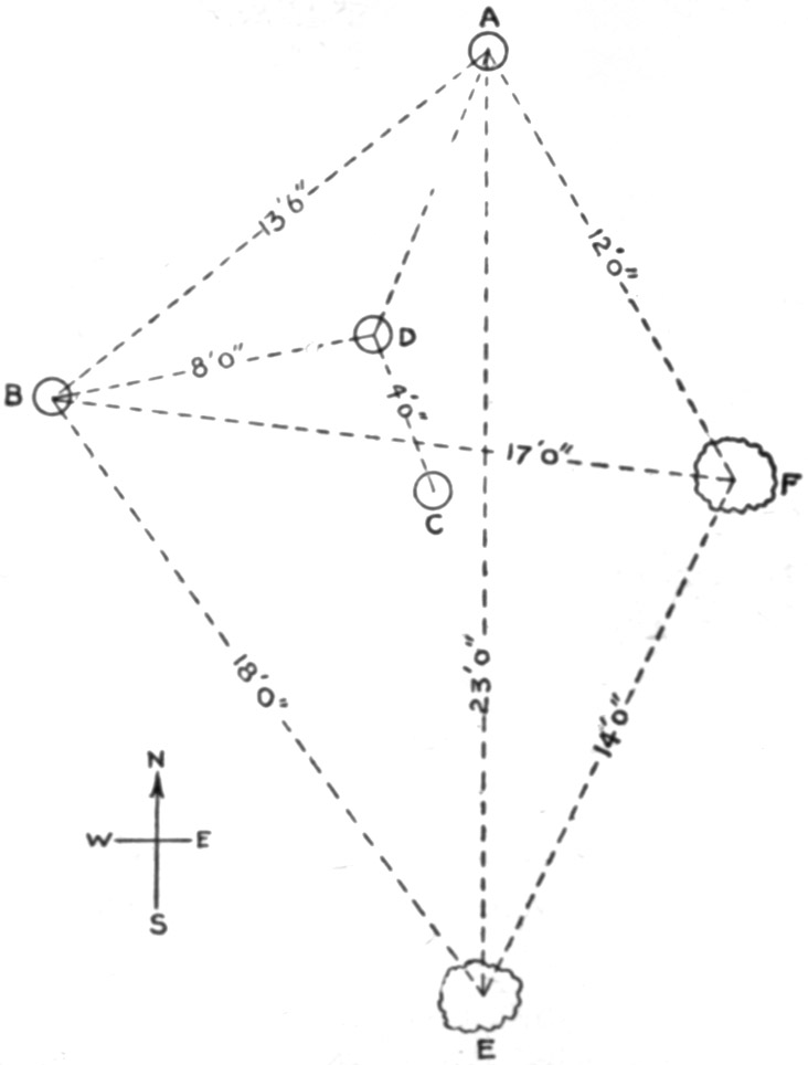
Fig. 37.—Plan of House Mound in St. François County, Mo.ToList
This mound offers confirmation of the belief that such structures, or some of them at least, mark the sites of dwellings. With the two trees, E and F, the posts, A and B, would form the corners of an irregular quadrangle; the two posts, C and D, would support the inner ends of roof timbers. While no trace of posts or roof timbers remained, it is difficult to imagine for what other purpose these holes would be dug; and in this heavy, wet earth all traces of wood must in time disappear. Conversely, the total absence of a fireplace, potsherds or other remains, and of any sign of a floor, would serve to dispel the assumption that this spot was ever inhabited even for a short time. The evidence is as strong one way as it is the other.
In short, the limited observations above recorded leave the question of origin and purpose just where it was.
Some years ago one of the mounds at Ferguson, St. Louis County, was opened. No remains of any sort were discovered, according to the report of the excavators; but on the original surface, at the center of the mound, was a fire bed in and about which were ashes, charcoal, and fragments of rude pottery.
No excavations have ever been made in the mounds near Granite Mountain; but a tortuous little stream has undercut several of them, thus making vertical sections as in the case of the mound at Hunter's, near Farmington. In some mounds only a small portion near the margin has been removed; in others the erosion has progressed to such an extent that observations were possible at varying distances, to and beyond the center. In every instance a monotonous uniformity of appearance prevails from the top of the mound into the underlying gravel. At no level is there a sign of a floor, fire bed, or other evidence of human work; and no difference can be detected between the earth upon which the mound rests and that on either side. Yet the mounds are indubitably artificial.
Exactly the same remarks apply to several mounds on the County Farm, near Salem. A little creek and a drainage ditch have cut away varying portions of them, and they merge insensibly into the soil and gravel on either side.
In further support of the theory that these mounds are the remains of earth-covered houses, a few extracts relating to the area under discussion will be given from Dr. Cyrus Thomas in the Twelfth Annual Report of the Bureau of Ethnology:
Near "Beckwith's Fort," in Mississippi County, Missouri, are (p. 189)—
Low, flattish, circular mounds * * * [which] appear to belong to two classes, those used for dwelling sites and those used for burial purposes, the former being the higher and the color of the surface layer darker than that of the other class. This darker color of the surface layer is probably due to the fact that immediately below it are found fire-beds with burnt earth, charcoal, ashes, and the bones of animals, (mostly split). There are seldom any human skeletons or entire vessels of pottery in the mounds of this class though the earth is filled with fragments of broken vessels.
In describing mound excavations in Crittenden County, Arkansas, the explorer states (p. 227):
As an almost universal rule, after removing a foot or two of top soil, a layer of burnt clay in a broken or fragmentary condition would be found, sometimes with impressions of grass or twigs, which easily crumbled but was often hard and stamped apparently with an implement made of split reeds of comparatively large size. This layer was in places a foot thick and frequently burned to a brick red or even to clinkers.
Below this, at a depth of 3 to 5 feet from the surface, were more or less ashes, and often 6 inches of charred grass, immediately covering skeletons. The latter were found lying in all directions, some with the face up, others with it down, and others on the side. With these were vessels of clay, in some cases one, sometimes more.
The positions of the skeletons in this mound would indicate that while the inmates of the house were asleep the roof fell and killed them. It was customary among some southern Indians to bury the dead under the floors of the houses; but the text clearly shows that these skeletons were lying on the floor. It would be supposed from most reports, not only in the volume quoted, but from various other sources as well, that only the walls of these houses were plastered with mud, the roof being of thatch alone. It seems to be overlooked that the tops of the houses would have even more need of such protection than the sides. The marks indicating that the clay was "stamped apparently with an implement made of split reeds" are only the impressions of the reeds or saplings by which the clay was supported; the "brick like" or "clinker like" condition of the clay being due, of course, to the destruction of the house by fire.
Adair, in his History of the Southern Indians, says they daub their houses with tough mortar mixed with dry grass; that they build winter or hot houses after the manner of Dutch ovens, covered with clay. Again:
They are lathed with cane and plastered with mud from bottom to top, within and without, with a good covering of straw.
This seems to mean that the entire building was plastered with mud, and then covered with grass to shed the rainfall.
In a mound in Arkansas County, Arkansas (Twelfth Ann. Rept. Bur. Ethn., p. 231)—
About 2 feet under the surface was a thick layer of burnt clay, which probably formed the roof. In tracing out the circumference a hard clay floor was found beneath, and between the two several inches of ashes, but no skeletons. There were a great many pieces of broken dishes so situated as to lead one to believe they were on top of the house at the time it was burned.
The fact that no skeletons or utensils were discovered on the floor finds its most reasonable explanation in the supposition that the inmates, finding their abode to be unsafe, moved out and took their possessions with them. This would account, also, for the absence of such remains in similar mounds farther north. The abundance of pottery fragments found in this case, and in many others, may mean only that these were worked in as a part of the clay roofing. They would be of some service in holding the clay in place in wet weather.
It is quite probable that the continuous, though fragmentary, layer of burned clay on the floor so often noted is due in part at least to the material forming the roof. The walls would be more apt to fall outward than inward, and would be more liable to crumble than to fall as an intact mass. In fact, this is clearly shown by the statement (p. 229) that in certain house sites in St. Francis County, Arkansas,
The edges are all higher and have a thicker layer of this [burned] material than the inner areas.
Further, in describing explorations of certain "hut rings" at "Beckwith's Fort" in Mississippi County, Missouri (p. 187), the report states that they are
from 30 to 50 feet in diameter, measuring to the tops of their rims, which are raised slightly above the natural level. The depth of the depression at the center is from 2 to 3 feet. Near the center, somewhat covered with earth, are usually found the baked earth, charcoal, and ashes of ancient fires, and around these and beneath the rims [that is, the surrounding ring or embankment] split bones and fresh-water shells. Often mingled with this refuse material are rude stone implements and fragments of pottery.
Note is made of
the similarity in the size, form, and general appearance of these depressions and earthen rings to those of the earth lodges of the abandoned Mandan towns along the Missouri River.
It appears, too, that certain sites were occupied for long periods, new houses being constructed when necessary. In describing mounds in Poinsett County, Arkansas, the same writer says (p. 205) that
The positions and relations of these beds * * * make it evident that upon the site of one burned dwelling another was usually constructed, not infrequently a third, and sometimes even a fourth, the remains of each being underlaid and usually overlaid in part by very dark, adhesive clay or muck. * * *
The peculiar black color of these beds is chiefly in consequence of the large proportion of charcoal with which they are mixed, some of it doubtless the fine particles of burned grass and reed matting with which the cabins appear to have been thatched.
These layers of "very dark" material undoubtedly are remains of mud from the adjacent swamps, which was mixed with or plastered over the grass roofs. It is difficult to understand how they could have become mixed after the burning.
As showing the extent to which this prolonged occupancy was carried, we are informed (p. 254) that in Coahoma County, Mississippi, a mound was—
oval and rounded on top, 210 feet long, 150 broad at the base, and 16 feet high. This mound and several smaller ones near it are so nearly masses of fire beds, burnt clay, fragments of stone and pottery, together with more or less charcoal and ashes, as to indicate clearly that they are the sites of ancient dwellings thus elevated by accumulation of material during long continued occupancy.
In still other portions of the country besides those already mentioned are evidences of similar houses whose sites are now marked by mounds. In southern Ohio, especially, records of excavations contain numerous references to post holes under mounds both large and small. In the case of the former, so far as we may judge from the reports, the houses were destroyed before the mounds were built, and it does not appear that they were ever covered with earth. In the small, low, flat mounds, under which such holes existed, no thought was taken that these may mark the position of posts used to support a roof; all mounds were explored with the idea that they were for burial purposes, consequently no attention was paid to these features.
The Mandan houses, as described by Lewis and Clark, Catlin, and others, when fallen into ruins would leave exactly such mounds or hut rings as those found in Missouri and Arkansas.
It is now generally conceded that the wall or embankment at Aztalan, Wisconsin, concerning which so many wild theories have been promulgated, was simply a series of such house sites connected by a low ridge. The evidences of mysterious sacrificial altars seem to be due only to the destruction of such houses by fire.
In Wisconsin, also, and in Minnesota, are many small mounds apparently of this character which are due to an extinct tribe known to the Sioux and Chippewas as "The Ground House Indians."
In 1887 I became acquainted, at Munising, Michigan, with Mr. William Cameron. He was of the Scotch clan of Camerons, a nephew of a former Governor of Canada. Educated for a profession, he made a visit to relatives in Canada in early manhood, and the attractions of the wilderness proved so great that he never returned to his home. At the time I met him he was 84 years of age, in full possession of his mental faculties. For more than 60 years he had traversed the Lake region, his fur trading and trapping expeditions having carried him over all the country from Montreal to the mouth of the Mackenzie River. Much of his life had been spent among the Indians, especially the Sioux and Chippewas. He learned from them all they could tell him of their tribal history and former methods of living. The Chippewas told him that when they first came into the country they found the Sioux in possession, but finally, obtaining arms from the French, they drove the Sioux westward.
The "old men" of the Sioux corroborated this tradition and told Cameron that as they went westward they came to a race of people who lived in mounds which they piled up. These people were large and strong, but cowardly. "If they had been as brave as they were big," said the Sioux, "between them and the Chippewas we would have been destroyed; but they were great cowards and we easily drove them away."
Mr. B.G. Armstrong, of Ashland, Wisconsin, told me that he had taken great pains to investigate this tradition. From all that he could gather by much inquiry among the Indians and from his own observations, he was satisfied of its correctness. These people, whom the Sioux called Ground House Indians, built houses of logs and posts, over and around which they piled earth until it formed a conical mass several feet thick above the roof. Their territory extended from Lake Eau Claire, about 30 miles south of Lake Superior, to the Wisconsin River near Wausau or Stevens Point; down the Wisconsin a short distance; thence west into Minnesota, but how far he could not say; then around north of Yellow Lake back to the Eau Claire region. The Sioux exterminated the tribe, the last survivors being an old man and a woman who had married a Sioux. They were taken to the present site of Superior, near Duluth, and "died about 200 years ago"—that is, in the last quarter of the seventeenth century.
Gordon, an intelligent Indian living at the town of the same name, a short distance south of Superior, was familiar with this tradition, as were other Indians with whom I talked, and who accepted it as a well-known fact. Gordon related that he had heard "the old men" say these Indians erected their houses of wood and piled several feet of dirt over them; and they buried their dead in little mounds out in front of their houses and a few hundred feet away. He told of a mound that was opened near Yellow Lake in which the position and condition of the skeletons, two or three of children being among them, showed "as plainly as anything could" that they had been sitting or lounging around the fire, when the roof fell in and crushed them.
There is a "Ground House River" in eastern Minnesota, which probably derives its name from this people.
FOOTNOTES:
V. ARCHEOLOGICAL WORK IN HAWAIIToC
INTRODUCTION
The ethnologist or archeologist desiring to conduct explorations on the Hawaiian Islands will find it necessary to begin his labors at the Bishop Museum in Honolulu. This museum contains an extensive collection of articles, classified, arranged, and labeled, illustrating every phase of native life as it has existed since the islands have been known to white men, as well as many of the implements and objects pertaining to agriculture, fisheries, and domestic occupations of earlier times. Models or casts of houses, and of individuals engaged in various lines of industry, give the visitor a clear idea as to the routine of ordinary daily life. A careful study of all these things enlightens him in regard to what he may expect to find and to the meaning of such discoveries as he may make.
The extensive library which belongs to the museum contains every publication relating not alone to the islands but to all the archipelagoes of the southern Pacific that it is possible to procure; and among the most valuable of the volumes are the reports and memoirs of the museum itself, in which are set forth the observations and deductions of numerous investigators who, either in behalf of the museum or under its auspices, have endeavored to find a solution for the many problems involved.
Equally valuable to the student are the information, interpretations, and instruction freely placed at his disposal by those connected with the museum, especially by Dr. Brigham, the former director, whose long and busy life has been devoted almost entirely to a study of the Polynesian groups; by Professor Gregory, the present director, who with tireless energy is the impelling force behind various lines of scientific research; by Mr. Stokes, curator of the ethnological department, who for more than a score of years has been surveying, photographing, and collecting in every part of the islands; by Mr. Thomas G. Thrum, of Honolulu, who has completed, in manuscript, a volume containing a list and description of more than 500 heiaus on the islands; and by various other men who, in private life, have devoted much time and close attention to whatever may pertain to native life and customs.
MOLOKAI ISLAND
Following the advice of those whose knowledge gave them authority to speak decisively, the initial base of research was the island of Molokai, which presents the best conditions for study. It lies off the usual lines of travel, offers no inducement to tourists who wish to have the benefit of good roads and comfortable hotels, and consequently is seldom visited except by those who are called on business or who go as the guests of the few residents there.
Mr. George Cooke, one of the owners of a large cattle and sheep ranch on the island, and greatly interested in its aboriginal history, gave most generous aid in a reconnoissance of such parts as he had time to visit. He placed his beautiful summer residence at the disposal of Prof. Gregory and the writer, and conducted the explorers to nearly all the places of interest which could be approached by automobile. Mr. James Munro, manager of the ranch, also rendered valuable assistance. Owing to his long residence here he has become thoroughly familiar with every noteworthy feature, and pointed out many remains which, without his guidance, would have been missed altogether. Fully acquainted with the life of the Hawaiian people, he made clear the origin and purpose of many things that, lacking his intelligent explanation, would have been without significance.
Although there are now comparatively few Hawaiians on Molokai, it is evident that the island at one time supported a dense population. Along the southern, or leeward, coast are numerous fish ponds formed by building a stone wall across an inlet or, more frequently, by constructing it with the ends on shore and carrying it around a section of the open sea. The walls are strong enough to resist the waves, well above the level of high tide, and surround spaces of various areas up to 70 acres. These ponds were stocked with numerous kinds of fish which, thus protected from their natural enemies, increased rapidly and formed an unfailing food supply. The antiquity of these ponds is denoted by the amount of silt partially filling them, brought down from the mountains by erosion of the soil. They are still used to some extent by Hawaiians as well as by other residents.
Inland, low walls of stone or earth, or both, surround hundreds of old taro patches, one variety of these plants requiring an abundant supply of water during its growth. The poi made from taro was the principal vegetable food of the inhabitants. Sweet potatoes were also a leading article of diet. The fields in which they were grown may still be identified here and there by the little ridges heaped up. All these, with the addition of migratory birds and fowls which at certain seasons swarmed on the different islands, supplemented by various nuts and fruits growing spontaneously, provided a varied and ample food supply. Mammals, except the pig, dog, and rat (really a large mouse), which came in with the early natives, were unknown prior to the advent of the whites. There were no land reptiles and few indigenous noxious insects; although mosquitoes, not to mention certain domestic pests, abound in a few places, and there are some scorpions and centipedes; but these, like measles, smallpox, tuberculosis, and worse diseases, are adjuncts of an enforced civilization. The mongoose, brought in to destroy rats, and the myna bird, to devour insects, are themselves now beginning to be detrimental.
Along the coasts, on the headlands and lower hills, and to a less extent farther inland, are village sites, foundations of temples and houses, garden patches inclosed by stone walls, and long rows of stones, some of which are borders of roads or trails, others being for purposes which are undetermined. Among these, taro beds and sweet potato patches may still be traced.
The most remarkable among the remains are the great temple site on Senator Cooke's ranch, toward the east end of the island, and the "paved trail" 10 miles down the coast from Kaunakakai, the principal village and harbor. The former is rectangular in outline, built on irregular ground, of stones large and small, to form a level platform on which a thousand persons could assemble without being hampered for lack of room. The outer faces of the walls vary from 3 to 20 feet in height; and except at the lowest parts there are terraces or steps all around, about 5 feet in height and of differing width. Surrounding this platform, extending for half a mile up the little valley of which it marks the entrance, on the slopes to either side, and on the nearly level area reaching down to the sea in front, are all the indications of a populous settlement.
It is said that the ruins were formerly much more numerous and extensive, the larger part of them being swept out of existence by a great rush of water from the mountains "a long time ago."
The "paved trail" is a causeway of large stones. Some parts of it are obliterated by slides and encroaching ravines; other parts preserve the original condition and appearance. The width is not quite uniform, as the stones are of different sizes, but it departs very little either way from 6 feet. So far as can be judged in its present overgrown state, it extends in a straight line for about 2 miles, from the beach to a point on the hill at an altitude of fully 1,000 feet. To what it led, or why it was built, are questions awaiting an answer.
All of these places are now abandoned except a few villages along the coast. The people are not here to occupy them, and even if they were the conditions have become so changed that residence about them is no longer feasible. At the temple site, for example, the extent of the old taro beds predicates an abundance of water; at present, the one family living near by must carry it in a dry season from the well or spring of a neighbor. There is no steady water supply within miles of the "paved trail."
Clearly, extensive changes have taken place in recent times in climate and perhaps in topography. Fifty years ago forests of large trees grew over hundreds of square miles on the southern slopes of Molokai where at the present time there is only grass, or where algaroba trees, similar to the mesquite of the southwestern United States, are now spreading. This deforestation is still going on; dead or dying trees fringe the timber still standing. The cause of this progressive barrenness has not, so far, been, fully ascertained; there is undoubtedly a connection between it and the diminished water supply, though which is cause and which is effect, or whether both are due in common to some atmospheric phenomenon, is unknown. One result, however, is apparent. The roots of the forest trees do not extend deep into the earth, but spread out over the surface like those of pine trees. Thus much of the rainfall was prevented from escaping rapidly and such as was not absorbed by the roots made its way into the ground beneath the upper soil, whence it percolated downward to feed the springs. Now the greater part of the water runs off and is lost. For this reason large areas once well populated are no longer habitable.
Molokai, like other islands of the group, contains no stone except of volcanic or coral formation. There is no chert or similar material from which chipped implements can be made; nor, as would naturally be expected, is there any obsidian suitable for such manufacture. It may occasionally be seen on the sites of villages, but always in small angular fragments seldom more than half an inch in any dimension, always coarse-grained, even porous, and never of a quality which can be flaked into definite forms. No doubt its only use was as an abrasive, after being pounded fine. Rarely, quartz or chalcedony is found; it resembles the deposit around hot springs or in fissures, and, like the obsidian, is in fragments too small to be utilized except as a grinding or polishing material for smoothing wrought objects.
Manufactured stone specimens are confined principally to three general classes: Adzes, for working in wood; pestles, for pounding the taro root; and discoids, for games. The last are exactly similar to the chunkey stones so abundant in the States, except that none of them have concave or hollowed faces, and they are used in the same way. There were three forms of the game: To hurl or roll a disk farther than an opponent; to strike a pole or other mark set up; and to test the inherent magical powers of the stones by rolling them in such a way that they would collide, the object in this case being to see which one might prove victorious by breaking the other or forcing it out of its course. A suitable arena for the contest was prepared by carefully leveling and smoothing a straight, narrow strip of ground to any length desired, a slight wall being thrown up along each margin.
Pottery was unknown, there being no clay suitable for making it. Calabashes or gourds and wooden trays served as receptacles, though stone dishes or bowls are sometimes found. Along the coast occur sinkers, either plummet-shaped or half-ovoid like an egg divided lengthwise. This form has a groove around the longer diameter, crossing the flat face, and was tied to a white shell as a sinker in catching squids or cuttlefish, a hook being attached to the line. Coral was much used as files or rasps. There are a few objects whose purpose is problematical; and some highly polished black disks which, laid flat and covered with a film of water, make excellent mirrors; but aside from what is here mentioned, not much worked stone is found. Wood, bone, and shell served as the raw material for nearly all other needs.
Graves, or what are supposed to be graves, marked by cairns 3 or 4 feet high, or perhaps by only one or two layers of stones, are found, though rare. Many so-called caves—which are merely "tunnels," "bubbles," or "blow-holes" in the lava—were utilized as burial vaults. The natives vigorously protested against an attempt to excavate any of these, claiming that their ancestors or members of their families are buried in them and must not be disturbed. In the dunes human skeletons are frequently exposed by the shifting of the sands by the high wind. The natives seem to have little regard for these. Perhaps they are of the "common people," while cairns cover the chiefs or priests. There is a tradition that in "the old times" most of the dead were cast into the ocean as an offering to the Shark God.
There are no mounds or other structures of earth; everything was built of stone. All structures began at the surface of the ground. No evidence has been found of an occupation earlier than that of the present Hawaiian people. At no point examined in ravines or cliffs was there the slightest hint of human life at a period antedating that beginning with the race discovered by Captain Cook. Consequently no extended excavations were attempted. The results of some examinations made in three different places will be presented.
About 10 miles in an air line from Kaunakakai and the same distance from Mr. Cooke's home, on a mountain known as Mauna Loa, is a narrow, sharp ridge extending nearly south and terminating abruptly at the junction of two deep ravines. On the end of this are two house sites, or heiaus, which had never been disturbed. They are as nearly rectangular as the irregular stones of which they are built will permit. The larger (A) has its south wall at the edge of the low cliff, with its sides nearly on the cardinal lines. Omitting inches from the measurements, its outer dimensions are: North wall 38 feet, south wall 32 feet, east wall 33 feet, west wall 32 feet. The corresponding inside measurements are 21 feet, 19 feet, 21 feet, and 22 feet. Thirteen feet north from the north wall is a stone pile 13 feet north and south by 10 feet east and west, 18 inches high. Ten feet west of this is a single layer of stones covering an area 7 feet east and west by 4 feet north and south. At 9 feet out from the middle of the west wall is a platform 7 by 7 feet, its west edge on large stones in place. At the west end of the north wall are three large flat stones, one of them forming the corner, the two others west of this, the three being up-edged and in a continuous line.
Within the inclosure, at the southern end, is a closely laid pavement formed of a single stratum of loose stones, laid on the earth, and covering a space 20 feet east and west by 10 feet north and south. Along the inside of the wall, at the northeast corner, is a similar pavement 12 feet north and south by 4 feet 6 inches east and west, and a foot high. Both of these pavements were probably intended for seats and beds. On the larger pavement, 5 feet from the south wall, 9 feet from the east corner, was a boulder, its diameters 11, 12, and 15 inches, whose largest surface lay uppermost and was hollowed out to form, a deep saucer-shaped depression like a mortar; but as there was nothing to grind, it was probably to crack or pound nuts in. At the middle of the southeast quarter of the inclosure was a pile of stones 3½ feet across and 1 foot high; there was nothing under them. Seven feet from the north wall, 10 feet from the east wall, was a fireplace formed of two slabs on the east and west sides and a flattened boulder on the south side, all upedged, the north side being left open. Its bottom was undisturbed earth, a foot lower than the level of the platforms. It would seem, though this is uncertain, that the platforms or pavements were on the original surface level, the unpaved space being cleared out to the level of the bottom of the fireplace, and that this space had been filled with earth blown in by the winds after the spot was abandoned. From outside to outside the upedged stones measured 26 by 28 inches; the space inside 18 by 20 inches. On the west edge was a large grinding stone, the amount of wear on its surface indicating much use. A pavement 4 feet wide reached from the open side of the fireplace to the north wall.
In the cavity was about half a bushel of small stones, most of them burned. When meat was to be baked, a fire was made in the pit and as many of the stones as required were heated; they were placed in the body cavity, in the mouth, and in slits cut in the skin of the animal, which was then deposited in the pit, closely covered, and left until thoroughly cooked. Similar ovens or barbecue holes, and the same method of cooking, are still in use among the natives in their villages.
Views of this house site and of the fireplace, taken from various directions, are shown in plates 38-40.
Nearly north of the house site (A), at a distance of 91 feet, is the similar structure (B). The ground on which this is built is 6 feet lower than at (A). Its measurements are 23 by 24 feet outside, 13 by 18 feet inside, longest north and south. The entire interior is paved. For a space of 8 feet from the north end the pavement is a foot higher than in the south end. Beginning at the foot of the south wall, on the outer side, and extending for 29 feet toward (A), there is a closely laid stone pavement 10 feet wide at the wall and gradually diminishing to a width of 5 feet; its termination is nearly square, the slight curve being apparently not intentional. The west edge of this pavement is in a straight line, the east edge being curved.
Partial views are given in plate 41.
Neither (A) nor (B) has any opening for a doorway, nor is there any apparent method of easy entrance, though a slight platform on the north side of (A) may have supported steps of wood.
These walls, as in all other heavy structures observed, were made by carefully laying up two rows of large stones at a little distance apart and filling the space between them with stones of any convenient size, thrown in at random. Timbers set in them formed the skeleton structure of a house which was completed of poles and smaller growth, the sides and roof being thatched. The weight of the stones held the main timbers against the force of the wind even in severe storms.
The surface over hundreds of acres around these ruins is covered with house sites, long straight rows of stones, and garden lots surrounded by stone walls. Shop refuse, mostly chips and spalls from adz making, sea shells broken to extract the mollusks, coral for abrading, adzes in all stages of finish, and many "olimaikis" (chunkey stones) are found. A mile away is a chunkey yard or bowling alley about 600 feet long on the crest of a ridge which overlooks the ocean on both sides of the island.