F. HAVERFIELD (continued 2)
Reading edition
In this system perhaps the most peculiar feature is the intermixture of square and oblong 'insulae'. It is not merely the variation which can be traced in Priene (fig. 5), where some blocks are rather more square or oblong than others, but where all approach the same norm. The Roman towns which we are now considering show two varieties of house-blocks. Sometimes the blocks are square; sometimes, perhaps more often, they are oblong approximating to a square, like the blocks of Priene. But in a few cases, as at Naples among the more ancient, and at Carthage among the later foundations, they are oblong and the oblongs are very long and narrow.
It is hard to detect any principle underlying the use of these various forms. No doubt differences of historical origin are ultimately the causes of the mixture. But our present knowledge does not reveal these origins. The evidence is, indeed, contradictory at every point. If the Graeco-Macedonian fashion be quoted as precedent for square or squarish 'insulae', the Terremare show the same. If the theoretical scheme of the earlier Roman camp seemed based on the long narrow oblong, the actual remains of legionary encampments of the second century B.C. at Numantia include many squares. If one part of Pompeii exhibits oblongs, another part is made up of squares. If Piacenza, first founded in north Italy about 183 B.C., and founded again a hundred and fifty years later, is laid out in squares, its coeval neighbour Modena prefers the oblong. If the old Greek city of Naples embodies an extreme type of oblong, so does the later Augustan Carthage (pp. 100, 113). In the historic period, it would seem, no sharp line was drawn, or felt to exist, between the various types of 'insulae'. In the main, the square or squarish-oblong was preferred. Local accidents, such as the convenience of the site at Carthage, led to occasional adoption of the narrower oblong.
The Roman land-surveyors, it is true, distinguished the square and the oblong in a very definite way. The square, they alleged, was proper to the Italian land or to such provincial soil as enjoyed the privilege of being taxed—or freed from taxation—on the Italian scale. The oblong they connected with the ordinary tax-paying soil of the provinces. This distinction, however, was not carried out even in the agrarian surveys with which these writers were especially concerned,[63] and it applies still less to the towns. No doubt it is a fiction of the office. It would be only human nature if the surveyors, finding both forms in use, should invent a theory to account for them.
The system sketched in the preceding paragraphs seems, as has been said (p. 73), to have sprung from a fusion of Greek or Graeco-Macedonian with Italian customs. Roman town-planning, like Roman art, was recast under Hellenistic influence and thus gained mathematical precision and symmetry. When this happened is doubtful. Foreign scholars often ascribe it to Augustus and find a special connexion between the first emperor and the chess-board town-plan. But the architect Vitruvius, who dedicated his book to Augustus and who gives some brief notice to town-planning, urges strongly that towns should not be laid out on the chess-board pattern, but rather on an eight-sided or (as we might call it) star-shaped plan.[64] He would hardly have denounced a scheme which had been specially taken up by his patron, nor indeed does his criticism of the chess-board system sound as if he were denouncing a novelty in Italian building.
On the other hand there seems no great difficulty in the idea that the regularization of the old Italian town-plan by Greek influence took place spontaneously in the late Republic. We cannot, indeed, date the change. It must remain doubtful whether it came by degrees or all at once,[65] and whether the right-angled plans of towns like Aquileia[66] or Piacenza belonged to their first foundation, i.e. to about 180 B.C., or to later rearrangements. But it seems reasonable to believe that a Graeco-Italian rectangular fashion of town-planning did supersede an earlier, irregular, Italian style, and had become supreme before the end of the Republic.
CHAPTER VII INSTANCES OF ITALIAN TOWN-PLANS
The preceding chapters have dealt with the origins and general character of the Italian town-plan. We pass now to the remains which it has left in its own home, in Italy. These are many. In one city indeed, the greatest of all, no town-planning can be detected. Like Athens and Sparta, Rome shows that conservatism which marks so many capital cities. No part of it, so far as we know, was laid out on a rectangular or indeed on any plan.[67] It grew as it could. Its builders, above all its imperial builders, cared much for spectacular effects and architectural pomp. Even in late Republican times the gloomy mass of the Tabularium and the temples of the Capitol must have towered above the Forum in no mere accidental stateliness, and imperial Rome contained many buildings in many quarters to show that it was the capital of an Empire. But for town-planning we must go elsewhere.
The sources of our knowledge are twofold. In a few cases archaeological excavation has laid bare the paving of Roman streets or the foundation of Roman house-blocks. More often mediaeval and modern streets seem to follow ancient lines and the ancient town-plan, or a part of it, survives in use to-day. Such survivals are especially common in the north of Italy. It is not, indeed, possible to gather a full list of them. He who would do that needs a longer series of good town-maps and good local histories than exist at present; he needs, too, a wider knowledge of mediaeval Italian history and a closer personal acquaintance with modern Italian towns, than a classical scholar can attempt. But much can be learnt even from our limited material.[68]
The evidence of the streets needs, however, to be checked in every case. It would be rash to assume a Roman origin for an Italian town simply because its streets are old and their plan rectangular. There are many rectangular towns of mediaeval or modern origin. Such is Terra Nova, near the ancient Gela in Sicily, built by Frederick Stupor Mundi early in the thirteenth century. Such, too, Livorno, built by the Medici in the sixteenth century. Such, too, the many little military colonies of the Italian Republics, dotted over parts of northern and middle Italy. Often it is easy to prove that, despite their chess-board plans, these towns do not stand on Roman sites. Often the inquiry leads into regions remote from the study of ancient history.
Fortunately, enough examples can be identified as Roman to serve our purpose. Some of these occur in the Lombardy plain where, both under the Republic and at the outset of the Empire, many 'coloniae' were planted full-grown and where town-life on the Roman model was otherwise developed. Not all these towns survive to-day; not all of the survivors retain clear traces of their Roman town-plan; in nine cases, at least, the streets seem unmistakably to follow Roman lines. Four of the nine date from early days; in the late third and the early second centuries (218-183 B.C.), Piacenza, Bologna, Parma, and Modena, were built as new towns with the rank of 'colonia'. The first three of these were later refounded, about 40-20 B.C.—whether their streets were then laid out afresh is an open question—and Turin and Brescia were added. In addition, Verona, Pavia, and Como won municipal status in or before this later date, though when or how they came to be laid out symmetrically is not certain.[69] And there are other less certain examples.
Other instances, but not so many, may be quoted from south of the Apennines. At Florence, for example, and at Lucca 'coloniae' were planted full-grown and the street-plans still record the fact. At Naples, at Herculaneum, perhaps at Sorrento,[70] proofs survive of similar planning. But the towns of central Italy were in great part more ancient than the era of precise town-planning, and many of them were perched in true Italian fashion on lofty crags—praeruptis oppida saxis—which gave no room for square or oblong house-blocks. In the period of the dying Republic and nascent Empire fewer 'coloniae' were planted here than in the north, while in much of southern Italy towns have in all ages been comparatively rare.
In the towns just noted we can trace many, though not all, of the original house-blocks. Usually the blocks are square or nearly so, as at Turin, Verona, Pavia, Piacenza, Florence, Lucca. Less often they are long and even narrow rectangles, as at Modena, and Sorrento, and above all Naples, and as usual it is not easy to understand the reason for the difference (p. 80).
Turin (fig. 15).
Of all the examples of Roman town-planning known to us in Italy, Turin is by far the most famous.[71] Here the streets have survived almost intact, and excavations have confirmed the truth of the survival by revealing both the ancient road-metalling and the ancient town-walls and gates. Turin, Augusta Taurinorum, began about 28 B.C. as a 'colonia' planted by Augustus. Its walls enclosed an oblong of about 745 x 695 metres (127 acres).[72] The sides are represented (1) on the north by the Via Giulio, in the western part of which the southern edge of the street actually coincides with the line of the Roman town-wall, while further east the Porta Palatina enshrines an ancient gate; (2) on the west by the Via della Consolata, and the Via Siccardi, the east side of which latter street seems to stand upon the Roman town-wall; and (3) on the south by the Via della Cernaia and Via Teresa, the north side of which stands over the Roman southern town-wall. (4) The east wall agrees with no existing street but may be represented by a line drawn through the Carignano Theatre and the western front of the Palazzo Madama, which contains the actual towers of the Roman east gate.[73] The north-west corner, uncovered in 1884, is a sharp right angle. This feature recurs at Aosta and at Laibach (pp. 90, 116), both founded, like Turin, in the Augustan age, and seems to belong to that period; later, it gave place to the rounded angle visible at Timgad (p. 109) and in many Roman forts of the middle Empire.
Of the interior buildings of the town little is known. The Forum perhaps stood near the present Palazzo di Città, and the Theatre was traced in 1899 in the north-east corner of the town, occupying apparently, a complete insula;[74] of the private houses nothing definite seems to be recorded.
But the street-plan has survived intact, except in two outlying corners. The town was divided up into square or nearly square blocks, of which there were nine counting from east to west and eight from north to south. Most of these 'insulae' measured about 80 yds. square.[75] A few were larger, 80 x 120 yds.; these were ranged along the north side of the street now called Via Garibaldi (formerly Dora Grossa), which represents the Roman main street between the east and west gates—in the language of the Roman land-surveyors, the decumanus maximus. This street cut the town into two equal halves. The other divisions of the town were no less symmetrical. But, as there were nine 'insulae' from east to west, the main north and south street could not bisect the town. Indeed, the south gate seems to have had five house-blocks west of it and four east of it, while the Porta Palatina stands further west, with six blocks on the west side of it. The north and south gates, therefore, are not opposite.[76] Whether this was the original plan is not clear, nor is the age of the surviving walls and gates quite certain; the bonding courses in some of the masonry of the walls does not seem Augustan. But the street plan may unhesitatingly be assigned to the first establishment of the town, about 28 B.C. Since, it has been extended far beyond the Roman walls. Nearly all modern Turin has been laid out, bit by bit, in imitation and continuation of the original Roman lines.
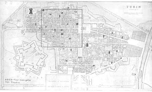
FIG. 15. TURIN FROM A PLAN OF 1844.
Aosta (fig. 16).
Another example of an Italian town-plan, from the same date and district as Turin, is supplied by Augusta Praetoria, now Aosta, some fifty miles north of Turin in the Dora Baltea Valley, not far from the foot of Mont Blanc.[77] Aosta was founded by Augustus in 25 B.C. on a hitherto empty spot, to provide homes for time-expired soldiers and to serve as a quasi-fortress in an important Alpine valley. Its first inhabitants were 3,000 men discharged from the Praetorian Guard, with their wives and children; its population may have numbered at the outset some 15,000 free persons, besides slaves. The town, as it is known to us from excavation and observation, formed a rectangle 620 yds. long and 780 yds. wide, and covered an area of about 100 acres (fig. 16). The walls formed sharp right angles at the corners, as at Turin. Within the walls were an amphitheatre, a theatre, public baths, a structure covering nearly 2 acres and interpreted as a granary or (perhaps more correctly) as a cistern,[78] and private houses as yet unexplored. Beneath the chief streets were sewers, by which indeed these streets were mainly traced.
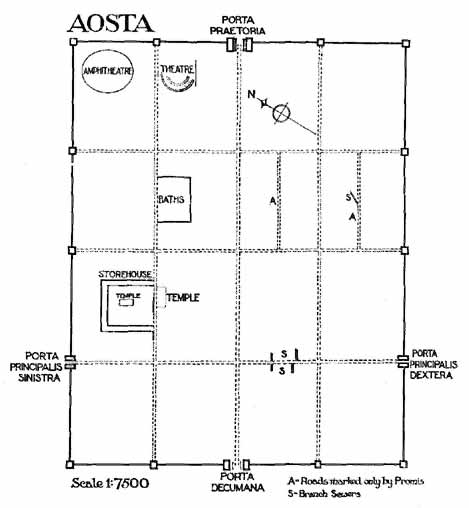
FIG. 16. AOSTA
The whole was divided by a regular network of streets into rectangular blocks. According to the latest plan of the site, there were sixteen blocks, nearly identical in shape and averaging 145 x 180 yds. (5½ acres). That, however, is an incredible area for single house-blocks, and it is to be noted that Promis shows two further roads (A, A in fig. 16). If these are survivals of other such roads, Aosta may have contained thirty-two oblong 'insulae', each nearly 220 x 540 ft., or even sixty-four smaller and squarer 'insulae', measuring half that size.[79] Four gates gave entrance; those in the two longer sides which face north-west and south-east, are curiously far from the centre and indeed close to the south-western end of the town. It is, of course, impossible to determine, without spade-work, which of the recognizable buildings of Aosta date from the foundation of the place in 25 B.C. But the general internal scheme and the symmetrical and practically 'chess-board' pattern of streets must date from the first foundation.[80]
Florence (fig. 17).
A yet more interesting instance of a Roman town-plan preserved in many streets may be found in Florence.[81] In Roman times Florence was a 'colonia'. When this 'colonia' was planted is very doubtful. Perhaps the age of Sulla (90-80 B.C.) is the likeliest date; all that is actually certain is that the foundation was made before the end of the first century A.D. This 'colonia', like others, was laid out in chess-board fashion, and vestiges of its streets survive in the Centro which forms the heart of the present town. The Centro of Florence, as we see it to-day, is very modern. It was, indeed, laid out a generation ago by Italian architects who designed the broad streets crossing at right angles which form its characteristic. But this 'Haussmannization' revived, consciously or unconsciously, an old arrangement. The plan of Florence in 1427 shows a group of twenty unmistakable 'insulae', each of them about 1-1/8 acre in area, that is, very similar in size to the 'insulae' of Turin. This group is bounded by the modern streets Tornabuoni on the west, Porta Rossa on the south, Calzaioli on the east, Teatina on the north; it covers a rectangle of some 305 x 327 yds., not quite 21 acres.
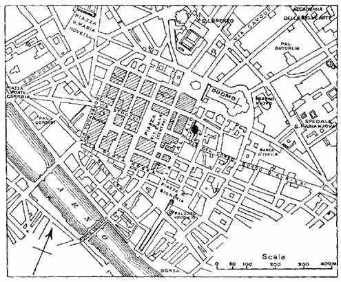
FIG. 17A. FLORENCE, SINCE THE REBUILDING OF THE CENTRAL PORTION (Centro shaded.)
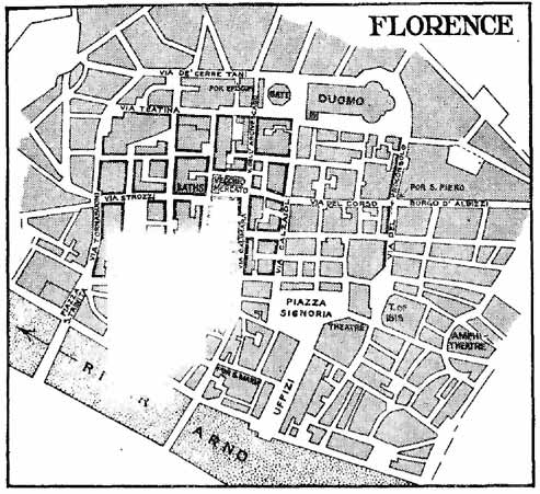
FIG. 17B. FLORENCE ABOUT 1795, FROM L. BARDI The chief streets which seem to have preserved Roman lines are marked in black.
The original Roman town presumably extended beyond these narrow limits. But it is not easy to fix its area, nor are unmistakable 'insulae' to be detected outside them. On the west the Via Tornabuoni seems to have marked the Roman limit, as it does to-day. On the north, a probable line is given by the gateway, Por Episcopi, which once spanned the passage—now an open space—on the east side of the Archbishop's Palace (plan 17 B). That gateway stood between the Via Teatina and the next street to the north, the Via dei Cerretani, and the Roman north wall and ditch apparently ran along the intervals between these two modern streets—as indeed the lines of certain mediaeval lanes suggest. On the east the 'colonia' is supposed to have stretched to the Via del Proconsolo and the old Por S. Piero, probably the original east gate. Here the traces of 'insulae' are ill preserved; the space in question would contain, and the mediaeval streets would admit of, twelve blocks in addition to the twenty noted above.
The southern limit of Roman Florence towards the Arno is altogether doubtful. There are, or were, traces of Roman baths in the Via delle Terme, and it has been thought that the town stretched riverwards as far as the old gate Por S. Maria and the Piazza S. Trinità. The gate, however, is ill-placed and the line of wall implied by this theory is irregular. The mediaeval streets point rather to a south wall near the Via Porta Rossa. The baths might perhaps be due to a later Roman extension, such as we shall meet at Timgad (p. 113). The Por S. Maria may even be due to one of the reconstructions of Florence in the Middle Ages. At the end we must admit that without further evidence the limits of Roman Florence cannot be fixed for certain. But the limits indicated above give the not unsuitable dimensions of 46 acres (380 x 590 yds.), while the history of the twenty indubitable insulae of the Centro remains full of interest. We see here, as clearly as anywhere in the Roman world, how the regular Roman plan has gradually been distorted by encroachments and how, even in its irregularity, it has had power to drive modern builders towards its ancient fashion.
Of the interior of the Roman town little is known. The streets now called Strozzi and Speziali plainly preserve the Roman main street from east to west, while the Via Calimara overlies that which ran from north to south. Where these crossed was the mediaeval Mercato Vecchio, now enlarged into a patriotic Piazza Vittorio Emmanuele; here we may put the Roman forum, and here too, by the former church of S. Maria in Campidoglio, was the temple of Capitoline Juppiter. There were also theatres, a shrine of Isis, and, outside the Roman limit, an amphitheatre still discernible in the curves of certain streets (plan 17 B). However small Florentia was, it possessed the true elements of the Roman town.
Lucca (fig. 18).
A good parallel to Florence may be found at Lucca, the ancient Luca, where again the streets preserve a rectangular pattern without showing clearly what was its full extent. Luca is said to have been founded as a 'colonia' in 177 B.C., but the statement is of doubtful truth. Certainly it was a 'municipium' in Cicero's days, and a little later, in the period 40-20 B.C., it received the rank of 'colonia' and many colonists, taken (as an inscription says) from discharged soldiers of Legions VII and XXVI. Whether the surviving traces of town-planning date from this latter event or from some earlier age is not easy to say. But of the street-plan there can be no doubt, though its original size is uncertain. A rectangular area about 700 yds. from east to west and 360 yds. from north to south is divided into fifteen square or squarish 'insulae' arranged in three rows. Each insula is about 3 acres, but those of the middle row are larger than the rest (150 x 150 yds.). The Via S. Croce which runs along the south side of this row was perhaps the main east and west thoroughfare of the town, the 'decumanus maximus', so that the larger 'insulae' correspond to those which appear in the same position at Turin and elsewhere (p. 88).
FIG. 18. LUCCA (The streets which preserve Roman lines are marked in black.) Not Available
Whether there were other 'insulae' besides the fifteen is doubtful. On the east there were certainly none: the two narrow parallel streets at the east end of the area just described are obviously due to a growth of houses along the line of the original east wall. The other limits are more obscure. Probably the north and west walls stood a little outside of the Via Galli Tassi (once S. Pellegrino) and the Via S. Giorgio, but there may well have been a row of insulae, now obliterated, south of the Via del Battistero. One or two interior buildings are known. The Forum appears to have stood where is now the Piazza S. Michele in Foro; close by was a temple; in the north-eastern quarter, at the Piazza del Carmine, was probably the theatre; near it but outside the walls was the amphitheatre, its outlines still visible in the Piazza del Mercato (110 x 80 yds. in greatest dimensions).[82]
Herculaneum (fig. 19).
To these examples from north Italy may be added two from the south, Herculaneum and Naples. Herculaneum had much the same early history as its more important neighbour Pompeii. First an Oscan settlement, then Etruscan, then Samnite, it passed later under Roman rule. After the Social Wars (89 B.C.) it appears as a 'municipium'; of its history from that date till its destruction (A.D. 79) we know next to nothing. But excavations, commenced in the eighteenth century and now long suspended, have thrown light on its ground-plan.[83] This was a rectangular pattern of oblong house-blocks, measuring 54 x 89 yds., or in some cases a little more, and divided by streets varying from 15 to 30 ft. in width which ran at right angles or parallel to one another. Only a part of the town has been as yet unearthed. In that a broad colonnaded main street ran from north-west to south-east; on the north-east side of this street stood a row of house-blocks with a structure taken to be a Basilica, and on the south-west of it were ten house-blocks, one of which includes some public baths. At the north end of this area are a theatre and temple, at the south end two large structures which have been called temples but are more like large private houses; on the east (according to the eighteenth-century searchers) are graves.
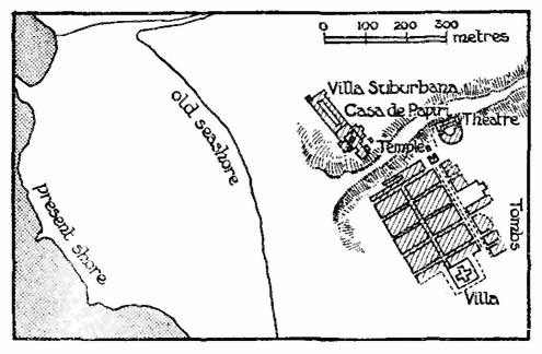
FIG. 19. HERCULANEUM
How much of the town has been uncovered, how much still lies hidden beneath the lava which overflowed it in A.D. 79, is disputed. Of its town-walls and gates no trace has yet been found. But nearly all its public buildings seem to be known; the graves on the east side, if correctly mapped by their discoverers and if coeval with the streets and houses, leave no room for further 'insulae' in that direction, while the great country-house called the 'Casa dei Papiri' plainly stood outside the town on the north-west. From these facts one modern writer has calculated that Herculaneum was less than a quarter of a mile long, less than 350 yds. broad, and less than 26 acres in extent—in short, not a sixth part of Pompeii. These measures are probably too small. The 'Basilica' on the north side of the main street cannot have stood on the extreme edge of the town. There must have been not three but four rows of house-blocks from south-west to north-east; the graves once noted in this quarter must be older than our Herculaneum or otherwise unconnected with it. The whole town must have been 40 or 45 rather than 25 acres in area. Even so it is a little town. The unenthusiastic references to it in ancient literature are, after all, truthful. Apart from the great villa outside it—possibly an imperial residence—it hardly deserved, or to-day deserves, to be excavated at the extraordinary cost which its excavation would involve.
The date of its planning is as doubtful as the extent of its area. One recent writer, Nissen, has suggested that it was reconstructed after an earthquake in A.D. 63 and was hardly completed before the eruption of 79. The earthquake is well attested. But it cannot possibly have wrecked the town so utterly as to cause wholesale rebuilding on new lines, and an inscription points rather to the time of Augustus. One Marcus Nonius Balbus (the text runs) built 'a basilica, gates and a wall at his own cost', and this builder Balbus was probably a contemporary of Augustus.[84] Others have preferred to think that the town-planning reveals Greek influences; they point to the Greek city of Naples, 7 miles west of Herculaneum, and the Doric temple at Pompeii, much the same distance east of it. However, neither the town-planning of Naples, to be discussed in the next paragraphs, nor that of Pompeii (p. 68), seems to be necessarily Greek, and Herculaneum itself contains nothing which cannot be explained as Italian. It is possible, though there is no record of the fact, that it received a settlement of discharged soldiers somewhere about 30 B.C. and was then laid out afresh. But here, as throughout this inquiry, more light is needed if the inquirer is to pass from guesswork to proven fact.
Naples (fig. 20).
One more example, from the neighbourhood of Herculaneum, may complete the list of Italian street-plans. Naples, the Greek and Roman Neapolis, was a Greek city, the most prosperous of the Greek towns in Campania.[85] After 90 B.C. it appears to have become a Roman 'municipium'. But it retained much of its Greek civilization. A writer of the early first century after Christ, Strabo, states that abundant traces of Greek life survived there, 'gymnasia, and athletic schools, and tribal divisions, and Greek names even for Roman things.' Even later Tacitus calls it a 'Greek city', and Greek was still used for official inscriptions there in the third century.
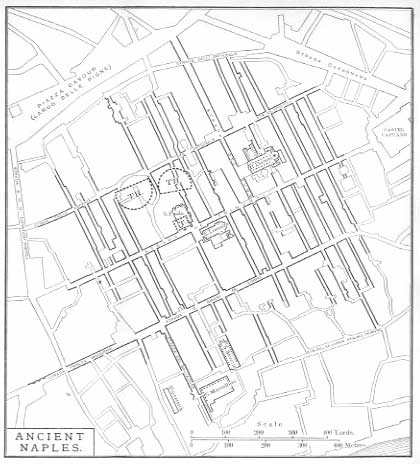
FIG. 20. NAPLES. ADAPTED FROM A PLAN OF 1865 (TH = Theatre, T = Temple.)
This Neapolis town had, as certain existing streets declare, a peculiar form of town-planning. The area covered by these streets is an irregular space of 250 acres in the heart of the modern city, about 850 yds. from north to south and 1,000 yds. from east to west.[86] In Roman days three straight streets ran parallel from east to west and a large number of smaller streets, twenty or so, ran at right angles to them from north to south. The house-blocks enclosed by these streets were all of similar size and shape, a thin oblong of 35 x 180 metres (39 x 198 yds.). Some of the public buildings naturally trespassed on to more than one 'insula'; a theatre appears indeed to have stretched over parts of three. In general, the oblongs seem to have been laid out with great regularity and the angles are right angles, though the 'insulae' in the northern and southern rows of house-blocks cannot have been fully rectangular and symmetrical.
This town-plan of Naples differs from any of those noted above. Its blocks are narrower than those in any Italian town, unless in Modena, and while they resemble the 'insulae' of the sixth region of Pompeii (fig. 13), are far more regular than those. Almost the only close parallel is that of Roman Carthage (fig. 24). As Naples was by origin and character a Greek city, these narrow oblongs have been supposed to represent a Greek arrangement. They do not, however, correspond to anything that is known in the Greek lands, either of the Macedonian or of any earlier period. The conclusion is difficult to avoid that this Greek city of Naples adopted an Italian street-scheme, but laid it out with more scientific regularity than the early Italians themselves. When this occurred and why, is wholly unknown. That the result is not an unpractical form of building is shown by the fact that similar long and narrow house-blocks are a characteristic feature of modern Liverpool, though they seldom occur in other English towns, unless intermixed with square and other blocks.
CHAPTER VIII ROMAN PROVINCIAL TOWN-PLANS. I
The provinces, and above all the western provinces of the Roman Empire, tell us even more than Italy about Roman town-planning. But they tell it in another way. They contain many towns which were founded full-grown, or re-founded and at the same time rebuilt, and which were in either case laid out on the Roman plan. But the modern successors of these towns have rarely kept the network of their ancient streets in recognizable detail. Though walls, gates, temples, baths, palaces, amphitheatres still stand stubbornly erect amidst a flood of modern dwellings, they are but the islands which mark a submerged area. The paths and passages by which men once moved across that area have vanished beneath the waves and cannot be recovered from any survey of these visible fragments. There is hardly one modern town in all the European and African provinces of the Roman Empire which still uses any considerable part of its ancient street-plan. In our own country there is no single case. In Gaul and Germany, two or three streets in Cologne and one or two in Trier are the sole survivals.[87] In Illyricum there is no example unless possibly at Belgrade. In the Spanish peninsula the town of Braga in northern Portugal seems to stand alone. In Roman Africa—Tunis, Algiers and Morocco—no instance has survived the Arab conquest.[88]
If, however, survivals of ancient streets are as rare in the provinces as they are common in Italy, the provinces yield other evidence unknown to Italy. In these lands, and above all in Africa, the sites of many Roman towns have lain desolate and untouched since Roman days, waiting for the excavator to recover the unspoilt pattern of their streets. If the Roman Empire brought to certain provinces, as it unquestionably did to Africa, the happiest period in their history till almost the present day, that only makes their remains the more noteworthy and instructive. Here the new art of excavation has already achieved many and varied successes. In the western Empire one town, Silchester in Britain, has been wholly uncovered within the circuit of its walls. Others, like Caerwent in Britain or Timgad and Carthage in Africa, have been methodically examined, though the inquiries have not yet touched or perhaps can never touch their whole areas. In others again, some of which lie in the east, occasional search or even chance discoveries have shed welcome light. Our knowledge is more than enough already for the purposes of this chapter.
We can already see that the town-plan described in the foregoing pages was widely used in the provinces of the Empire. We find it in Africa, in Central and Western Europe, and indeed wherever Rorrran remains have been carefully excavated; we find it even in remote Britain amidst conditions which make its use seem premature. Where excavation has as yet yielded no proofs, other evidence fills the gap. In southern Gaul, as it happens, archaeological remains are unhelpful. But just there an inscription has come to light, the only one of its kind in the Roman world, which proves that one at least of the 'coloniae' of Gallia Narbonensis was laid out in rectangular oblong plots. It is clear enough that this town-plan was one of the forms through which the Italian civilization diffused itself over the western provinces.
The exact measure of its popularity is, however, hard to determine. In the east it found little entrance. There, the very similar Macedonian and Greek methods of town-planning were rooted firmly, long before Rome conquered Greece or Asia Minor or Syria or Egypt. The few town-plans which have been noted in these lands, and which may be assigned more or less conjecturally to the Roman era, seem to be Hellenic or Hellenistic rather than Italian. They show broad stately streets, colonnades, vistas, which belong to the east and not to Italy. Even in the west, the rule of the chess-board was sometimes broken. Aquincum, near Budapest, became a 'municipium' under Hadrian; its ruins, so far as hitherto planned, exhibit no true street-planning. But that may be due to its history, for it seems not to have been founded full-grown, but to have slowly developed as best it could, and to have won municipal status at the end.
Roman Africa is here, as so often, our best source of knowledge. At Timgad (p. 109), a town laid out in Roman fashion with a rigid 'chess-board' of streets was subsequently enlarged on irregular and almost chaotic lines. At Gigthi, in the south-east of Tunis, the streets around the Forum, itself rectangular enough, do not run parallel or at right angles to it or to one another.[89] At Thibilis, on the border of Tunis and Algeria, the streets, so far as they have yet been uncovered, diverge widely from the chess-board pattern.[90] One French archaeologist has even declared that most of the towns in Roman Africa lacked this pattern.[91] Our evidence is perhaps still too slight to prove or disprove that conclusion. Few African towns have been sufficiently uncovered to show the street-plan.[92] But town-life was well developed in Roman Africa. It is hardly credible that the Africans learnt all the rest of Roman city civilization and city government, and left out the planning. The individual cases of such planning which will be quoted in the following pages tell their own tale—that, while the strict rule was often broken, it was the rule.
Orange (fig. 21).
The case which deserves the first place stands by itself. It is the one piece of written evidence (as distinct from structural remains) which has survived from Roman town-planning. Curiously enough, it was found not in Italy but in a province, and a province which, for all its wealth of Roman buildings, has not yet revealed the smallest structural proof of Roman town-planning. In April 1904 a scrap of inscribed marble, little more than 18 in. broad and high, was dug up at Orange, in southern France, right in the centre of the town. It is a waif from a lengthy document. But it chances to be intelligible. It enumerates six plots of land—'merides' it calls them, from a Greek word meaning 'share' or 'division'—which seem to have formed one parcel: each plot is numbered, and the length of its frontage on the public way (in fronte), the name of its lessee or manceps and that of his surety (fideiussor) are added. The frontages of four plots make up 200 ft. (those of the other two are lost), and it has been suggested that the six together made up 240 ft. The depth—which is not stated on the surviving fragment, but was doubtless uniform for all the plots—may then have been 120 ft., and the whole parcel may have covered 120 x 240 ft., that is, a Roman 'iugerum'. It was plainly a piece of town property. The largest 'meris', Plot v, measured only 25 by 40 yds. and no one would care for such a field or farm. Besides, this plot at one end adjoined a 'ludus' or gladiatorial school, and it fronted AD K, ad kardinem, on to the street called in surveying language the 'cardo'. The whole land apparently belonged to one lessee who held it from the municipality on something like a perpetual lease.[93]
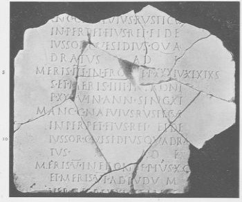
FIG. 21. INSCRIPTION OF ORANGE (From the Comptes-rendus de l'Académie des Inscriptions.)
Plot (meris) I (lost) ...
Plot II ... perpetual lessee (manceps) C. Naevius Rusticus: surety for him C. Vesidius Quadratus. Fronting the Kardo.
5
Plot III, frontage of 34½ feet and Plot IV, frontage of 35 feet; ground rent (?), 69½ denarii (in margin). Yearly rent II ... (?). Lessee and surety, as above. Fronting the Kardo.
10
Plot V, frontage 55½ feet, and Plot VI, next to the Ludus (gladiators' school), frontage 75 feet ...
Here, in short, is the record of an oblong 'insula' in the Roman town of Orange. It is doubtless part of a longer record, a register of house-property in the whole town. Orange, Colonia Iulia Secundanorum Arausio, was a 'colonia' founded about 45 B.C. with discharged soldiers of Caesar's Second Legion. Possibly the register was drawn up at this date; more probably it is rather later and may be connected with a census of Gaul begun about 27 B.C. Certainly it was preserved with much care, as if one of the 'muniments' of the citizens. The spot where it was dug up is in the heart of the ancient as well as of the modern town, close to the probable site of the Forum, and the inscription may have been fastened up in all its length on the walls of some public building. If, as is likely, the town owned the soil of the town, the connexion of the inscription with the Forum becomes even clearer. In any case, the town was plainly laid out in a rectangular street-plan. To-day its lanes are as tortuous as those of any other Provencal town.[94] A strange chance reveals what it and many other of these towns must once have been.
Timgad (figs. 22, 23).
From this piece of half-literary evidence we pass to purely archaeological remains, and first to the province of Numidia in Roman Africa and to the town of Timgad. The town of Thamugadi, now Timgad, lay on the northern skirts of Mount Aurès, halfway between Constantine and Biskra and about a hundred miles from the Mediterranean coast. Here the emperor Trajan founded in A.D. 100 a 'colonia' on ground then wholly uninhabited, and peopled it with time-expired soldiers from the Third Legion which garrisoned the neighbouring fortress of Lambaesis. The town grew. Soon after the middle of the second century it was more than half a mile in width from east to west, and its extent from north to south, though not definitely known, cannot have been much less. The first settlement was smaller. So far as it has been uncovered by French archaeologists—sufficiently for our purpose, though not completely—the 'colonia' of Trajan appears to have been some 29 or 30 acres in extent within the walls and almost square in outline (360 x 390 yds.). It was entered by four principal gates, three of which can still be traced quite clearly, and which stood in the middle of their respective sides; the position of the south gate is doubtful. According to Dr. Barthel, the street which joins the east and west gates was laid out to point to the sunrise of September 18, the birthday of Trajan.
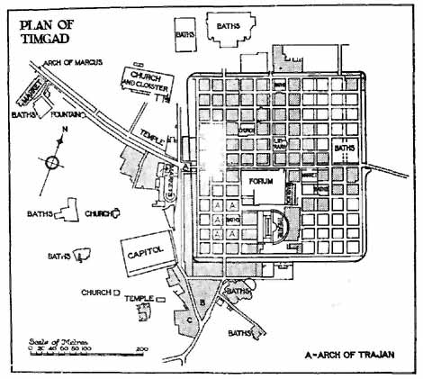
FIG. 22. AFTER CAGNAT AND BALLU (1911) (The six 'insulae' marked A are shown in detail in fig. 23. Unshaded 'insulae' are as yet unexcavated.)
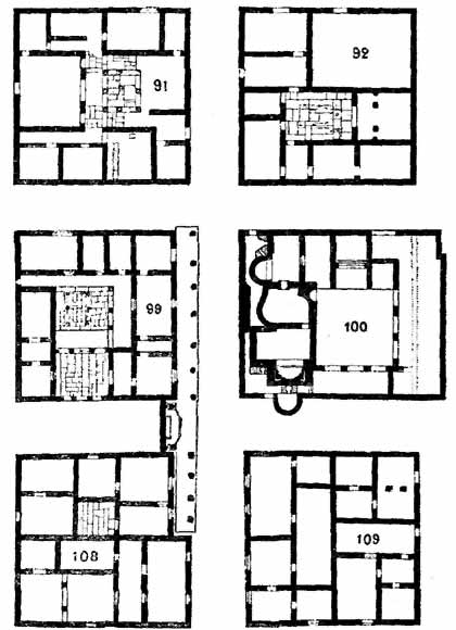
FIG. 23. SIX 'INSULAE' IN S.W. TIMGAD (After Prof. Cagnat). Nos. 91, 92, 99, one house each; 108, 109, 3 houses; 100, Baths.
The interior of the town was divided by streets into a chess-board pattern of small square house-blocks; from north to south there were twelve such blocks and from east to west eleven—not twelve, as is often stated. The possible total of 132 'insulae' was, however, diminished by the space needed for public buildings, though it is not easy to tell how great this space was in the original town. Ultimately, as the excavations show, eight 'insulae' were taken up by the Forum, four by the Theatre, three by the various Baths, one by a Market, one by a Public Library, and one by a Christian church. But some of these edifices were certainly not established till long after A.D. 100 and the others, which must have existed from the first, were soon extended and enlarged. A competent writer on the subject, Dr. Barthel, allows seven blocks for public purposes in the original town, but this seems too little. The blocks themselves measured on the average a square of 70 Roman feet (23 x 23 yards), and may have contained one, two, three, or even four houses apiece, but they have undergone so many changes that their original arrangements are not at all clear. The streets which divided these blocks were 15 to 16 ft. wide; the two main streets, which ran to the principal gates, were further widened by colonnades and paved with superior flagging. All the streets had well-built sewers beneath them.
Trajan's Timgad was plainly small. On any estimate of the number of houses, the original draft of veterans sent there in A.D. 100 can hardly have exceeded 400, and the first population, apart from slaves, must have been under 2,000. This agrees with the figures of Aosta (p. 89). There, 100 acres took 3,000 veterans and their families; here the area is about one-third of 100 acres and the ground available for dwellings may perhaps have been one-sixth. In neither case was space wasted. There was not probably at Aosta, there certainly was not at Timgad, any provision of open squares, of handsome facades, of temples seen down the vista of stately avenues; there were not even private gardens. The one large unroofed space in Timgad was the half-acre shut within the Forum cloister. This economy of room is no doubt due to the fact that the 'colonia' was not only a home for time-expired soldiers, but, as Prof. Cagnat has justly observed, a quasi-fortress watching the slopes of Mount Aurès south of it, just as Aosta watched its Alpine valley. As Machiavelli thought it worth while to observe, the shorter the line of a town's defence, the fewer the men who can hold it. The town-planning of Timgad was designed on other than purely architectural or municipal principles. For this reason, too, we should probably seek in vain any marked distinction between richer and poorer quarters and larger or smaller houses.[95] The centurions and other officers may have formed the first municipal aristocracy of Timgad, as retired officers did in many Roman towns, but there can have been no definite element of poor among the common soldiers.
Such was Trajan's Timgad, as revealed by excavations now about two-thirds complete. The town soon burst its narrow bounds. A Capitol, Baths, a large Meat-market, and much else sprang up outside the walls. Soon the walls themselves, like those of many mediaeval towns—for example, the north and west town-walls of Oxford—were built over and hidden by later structures. The town grew from one of 360 to a breadth of over 800 yds. And as it expanded, it broke loose from the chess-board pattern. The builders of later Timgad did not resemble those of later Turin. Even the decumanus, the main 'east and west' street, wandered away north-west in an uncertain curve, and all that has been discovered of streets outside the walls of Trajan is irregular and complicated. A town-plan, it seems, was binding on the first builders of the 'colonia'. It lost its power within a very few years.[96]
Carthage (fig. 24).
It remains to note another example of town-planning in a Roman municipality of the western Empire, which is as important as it is abnormal. Carthage, first founded—though only in an abortive fashion—as a Roman 'colonia' in 123 B.C. and re-established with the same rank by Julius Caesar or Augustus, shows a rectangular town-plan in a city which speedily became one among the three or four largest and wealthiest cities in the Empire. The regularity of its planning was noted in ancient times by a topographical writer.[97] But the plan, though rectangular, is not normal. According to the French archaeologists who have worked it out, it comprised a large number of streets—perhaps as many as forty—running parallel to the coast, a smaller number running at right angles to these down the hillside towards the shore, and many oblong 'insulae', measuring each about 130 x 500 ft., roughly two Roman iugera. The whole town stretched for some two miles parallel to the shore and for about a mile inland, and covered perhaps 1,200 acres. Its street-plan can hardly be older than Caesar or Augustus, but the shape of its 'insulae' appears to be without parallel in that age. It comes closest to the oblong blocks of Pompeii and of Naples (pp. 63, 100), and its two theatres also recall those towns. One reason for its plan may no doubt be found in the physical character of the site. The ground slopes down from hills towards the shore, and encourages the use of streets which run level along the slopes, parallel to the shore, and not more or less steeply towards it.[98]
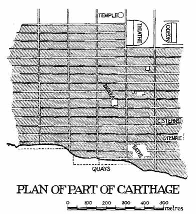
FIG. 24. A PART OF CARTHAGE Plan based on the Carte archéologique des ruines de Carthage, by Gauckler and Delattre.
Laibach (fig. 25), Numantia, Lincoln (fig. 26).
Three or four more ordinary examples chosen at random from provincial municipalities may show the diffusion of town-planning in the western Roman world. One example, from the borders of Italy, may be found just outside the pleasant town of Laibach in southern Austria. Here Augustus in 34 B.C. planted a 'Colonia Iulia Augusta Emona', and recent work of Dr. W. Schmid has thrown much light on its character. The colony was in outline a rectangle of nearly 55 acres (480 x 560 yds.), and was divided up into forty-eight blocks by five streets which ran north and south and seven which crossed them at right angles; of these forty-eight blocks some must, of course, have been taken up by public buildings. They varied in size: the largest as yet planned (II in fig. 25) measured 170 x 195 ft., or ¾ acre; two others measured 163 x 170 ft.; while one block, which contained one large house not unlike the Silchester 'inn', was 112 x 168 ft. (Plan, II), and the block next it was a trifle smaller. None of the dimensions show any trace of the normal 120 or 240 ft. (p. 79). The streets were very broad (37-40 ft.); one, which may be the 'cardo maximus', measured as much as 47 ft. across. Beneath the main streets were sewers, in the usual fashion. Round the whole town stood strong walls, reinforced at regular intervals by square projecting towers; the four corners were not rounded but rectangular, after the fashion of Aosta and Turin (pp. 87, 90).[99]
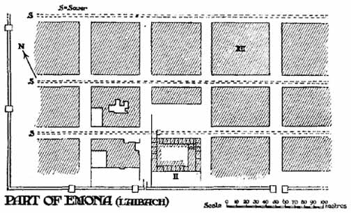
FIG. 25. A PART OF LAIBACH (From W. Schmid.)
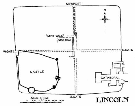
FIG. 26. LINCOLN, OUTLINE OF ROMAN WALLS (See p. 118.)
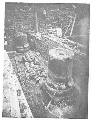
FIG. 27. LINCOLN, BASES OF COLONNADE UNDER BAILGATE (p. 118.)
For a second example turn to a remote corner of central Spain. The town of Numantia was famous in early days for its long struggle with the armies of the Roman Republic. Under Roman rule it was wholly insignificant. Over the débris of Numantine liberty a little Roman town grew up. But it is hardly mentioned save in one or two road-books. Yet it enjoyed some form of municipal status and its streets and houses show to the excavator traces of Roman town-planning. The streets ran parallel or at right angles to one another; the house-blocks measured some 50 yds. square.[100]
A third example may be drawn from our own country. Lincoln, the Roman Lindum, was established as a 'colonia' about A.D. 75, and the lines of its original area, its 'Altstadt'—for it was perhaps enlarged in Roman times,—can still be traced 'Above Hill' round the Castle and Cathedral (fig. 26). It formed a rectangle just over 41 acres in extent (400 x 500 yds.). Four gates, one of which still keeps its Roman arch, gave access to the two main streets which divided the town into four symmetrical quarters and crossed at right angles in the centre. Along one of these streets, which agrees, if only roughly, with the modern Bailgate, ran a stately colonnade (fig. 27), though whether this belonged to some special building or adorned the whole extent of street is not quite certain. Beneath the same street ran, as at Timgad and Laibach and elsewhere, the town sewer (fig. 28). Of the other main street and of side streets nothing is known, but we can hardly doubt that they carried out the chess-board pattern.[101]
Probably the other four municipalities in Britain were planned similarly, though the evidence is too slender to prove it. At Verulamium (for example) near St. Albans, a local archaeologist long ago claimed to detect a scheme of symmetrical house-blocks, resembling squares very slightly askew. Subsequent inquiry has shown that this scheme was merely or mostly imagination.[102]
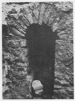
FIG. 28. LINCOLN. SEWER UNDER BAILGATE
CHAPTER IX ROMAN PROVINCIAL TOWN-PLANS. II
In the preceding chapters Roman town-planning has been treated in connexion with towns of definite municipal rank, which bore the titles 'colonia' or 'municipium'. The system is, of course, closely akin to such foundation or refoundation as the establishment of a 'colonia' implied in the early Empire, while the no less Roman character of the 'municipium' made town-planning appropriate to this class of town also.
It was, however, not limited to these towns. It appears not seldom in provincial towns of lower legal status, such as were not uncommon in Britain, in Gaul, and in some other districts. Four instances may be quoted from the two provinces just named. In the first, Autun, the town-planning is explained by the establishment of the town full-grown under Roman official influence. Unfortunately, however, little is known of the buildings, and it is difficult to judge of the actual character of the place. In the second case, Trier, we may conjecture a similar official origin. At Silchester, official influence seems also to have been at work, and it is not impossible that the fourth case, Caerwent, may be explained by the same cause. In these two latter, however, it is more important to observe the nature of the towns, which is better known than that of any others in western Europe. For they embody a type of urban life which is distinct from any that occurs in Italy or in the better civilized districts of the Empire, and which illustrates strikingly one stratum of provincial culture.
Autun (fig. 29).
Caesar won northern and central Gaul for the Roman Empire; it fell to Augustus to organize the conquered but as yet unromanized lands. Among many steps to that end, he seems to have planted new native towns which should take the places of old native tribal capitals and should drive out local Celtic traditions by new Roman municipal interests. These new towns did not, as a rule, enjoy the full Roman municipal status; northern Gaul was not quite ripe for that. But they were plainly devised to help Romanization forward, and their object is declared by their half-Roman, half-Celtic names—Augustodunum (now Autun), Caesaromagus (Beauvais), Augusta Suessionum (Soissons), Augusta Treverorum (Trier), and the like.[103] Of two of these, Autun and Trier, we chance to know the town-plans. The reader will notice a certain similarity between them.
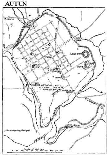
FIG. 29. AUTUN (After H. de Fontenay, 1889.)
Autun stands on the site and contains the stately ruins of the Roman Augustodunum, built by Augustus about 12 B.C. He, as it seems, brought down the Gaulish dwellers in the old native hill-fortress of Bibracte, on Mont-Beuvray, and planted them twelve miles away on an unoccupied site beside the river Arroux. The new town covered an area of something like 490 acres—that is, if the now traceable walls and gates are, as is generally thought, the work of Augustus. The town within the walls must have been laid out all at once. Quite a large part of it, perhaps has much as three-quarters, have revealed to the careful inquiries of French archaeologists a regular system of quadrangular street-planning, which may very likely have extended even through the unexplored quarter. The Roman street which ran through the town from south to north, from the Porte de Rome to the Porte d'Arroux, was fronted by at least thirteen 'insulae', and one of the streets which crossed it at right angles was fronted by eleven such blocks. They vary somewhat in size. The larger 'insulae', which lie west of the main north and south street, are oblong and measure about 150 x 100 yds. (say, 3 acres); many smaller ones are more nearly square (98 x 98 or 109 yds., about 2 acres).
But the regularity of the plan is plainly the work of civilized man. When the Celts were brought to live in a Roman city, care was taken that it should be really Roman.[104] Only we may perhaps wonder whether the plan may not have been drawn by Augustus with an eye more to the future than to the present and may have included more 'insulae' than there were actually inhabitants to occupy at once. That was the case certainly in the mediaeval English town of Winchelsea, where the rectangular building-plots laid out by Edward I have in great measure lain empty and untenanted to the present day.
Trier (fig. 30).
We may take another example from a northern city, Trier on the Mosel, in north-eastern Gaul (Augusta Treverorum). It was in its later days a large city, perhaps the largest Roman city in western Europe. When its walls were built and its famous north gate, the Porta Nigra, was erected, probably towards the end of the third century, they included a space of 704 acres, twenty-five times as much as the original Timgad, though, it must be added, this area may not have been wholly covered with houses. But it was then an old city. Its earliest remains date from the earliest days of the Roman Empire (A.D. 2), when it was founded, like Autun, on a spot which had (as it seems) never been inhabited before.[105] Of this first beginning we possess vestiges which concern us here. Eight or nine years ago, when the modern town was provided with drainage, the engineers of the work and the Trier archaeologists, headed by the late Dr. Graven, combined to note the points where the drainage trenches cut through pieces of Roman roadway.[106]
These points yielded a regular plan of streets crossing at right angles, which in many of its features much resembles that of Autun. Thirteen streets were traced running east and west, and eight (Dr. Graven says seven but his plan shows eight) running north and south. The east and west streets, with two exceptions, lay some 320 ft. from one another. The north and south streets varied, some observing that distance, others being no more than 260 ft. apart. As a result, the rectangular house-blocks varied also in size. The largest seem to be those which fronted a street that crossed the town from east to west, from the Imperial Palace to the Baths and the West Gate, and corresponds roughly with the present Kaiserstrasse. This may well have been the decumanus, the main east and west street of the 'colonia', and hence the house-blocks fronting it may have been unusually large (p. 77). One of them, near the Neumarkt, reached the awkward size of nearly 3½ acres (320 x 460 ft.). Others elsewhere were smaller, many measuring 320 x 320 ft., and others again 320 x 245 ft., rather less than 2 acres. In general, the 'insulae' on the east and west sides of the town were larger than those in the centre. The whole has a resemblance to Autun, and is more irregular than writers on Trier are ready to allow.[107]
How many houses may have occupied either a large or a small 'insula' is uncertain; indeed, we know next to nothing of the private houses of Roman Trier. Nor can we fix the number of the 'insulae'. On the west, and still more on the east and south-east of the town, much of the area was not touched by the drainage works and therefore went unexplored. We have proof only of streets and buildings for a mile in length and half a mile in breadth.
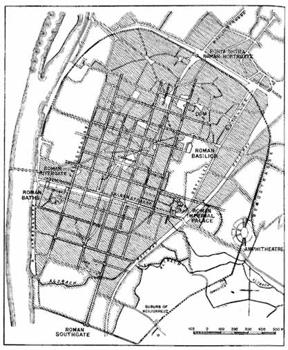
FIG. 30. TRIER (From plan by the late Dr. Gräven.)
Nevertheless we may make some guess at the original area. The streetage itself plainly dates from the original foundation of the Romano-Gaulish town by Augustus. There is, indeed, no other epoch in its history, so far as we know it, when a complete laying out could have been carried through. On the other hand, it is not probable that the first town was a mile long and half a mile wide. Possibly, as an acute German archaeologist has suggested, the small 'insulae' in the south of the town may indicate the line of an original wall and ditch which, like the first walls of Timgad, were overrun later by an expanding town. Certainly, early graves found hereabouts show that this space lay once outside the inhabited area, and similar evidence has been noted both on the north of the town in the Simeonstrasse, and on the west near the Mosel Bridge. If this be so, Augusta Treverorum may have at first covered only 120 or 130 acres; then, as the place spread beyond its original limits, its builders followed more or less closely the lines of the first streets, and, save near the Porta Nigra, continued the chess-board pattern as it was continued at Turin.
Silchester (figs. 31, 32).
Silchester, Calleva Atrebatum (fig. 31), shows a different picture, which is the more interesting because the excavations carried out in 1890-1909 have given us a fuller knowledge of the town than of any other Roman site in the western provinces.[108] It was, apparently, the old tribal capital of the Atrebates and the county-town of its district in Roman days; though not possessing the full municipal status, it was probably the seat of local government for a considerable neighbourhood. In outline it was an irregular eight-sided area of 100 acres, defended by a strong stone wall, which was added long after the original foundation. Internally it was divided up by streets which, except near the east gate, run parallel or at right angles to one another. Its buildings are: a Forum and Basilica, a suite of public baths, four small temples, a small Christian church, a hotel, and a large number of private houses. Its area is by no means filled with buildings. Garden ground must have been common and cheap, and the buildings themselves do not form continuous streets; they do not even front the roadway in the manner of houses in Italian towns. In these respects Silchester differs widely from any of the examples which we have already considered, so far as their internal buildings are known to us. I will not call it a 'garden city', for a garden city represents an attempt to add some of the features of the country to a town. Silchester, I fancy, represents the exact opposite. It is an attempt to insert urban features into a country-side.
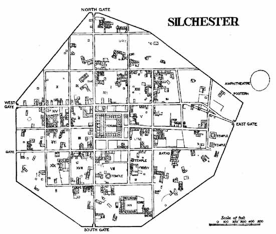
FIG. 31. SILCHESTER (For detail see fig. 32.)
Most of it must have been laid out at once. At any rate, the area of which the 'insulae' numbered X, XXI, XXXV, and XIX form the corners, and the Forum the centre, must have been planned complete from the first. This covers just 40 acres, and is divided into rectangular plots of which the smallest covers a little less than an acre and a half, while the largest fall little short of 3½ acres.[109] Outside this area, the division of the town into 'insulae' is less completely carried through, although most of the streets run straight on as far as the walls, and one or two details may tempt us to think that the division into 'insulae' was at some time extended beyond the line ultimately taken by the walls.
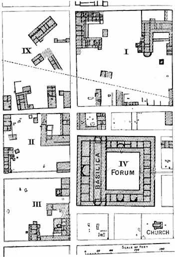
FIG. 32. DETAILS OF FOUR INSULAE, THE FORUM AND THE CHURCH AT SILCHESTER (From Archaeologia.)
But whatever the exact amount of Roman building and Roman street-plan given to Silchester when it was first laid out, the place is not in effect a real town. It is not merely that, as I have said, the houses do not form continuous streets. A glance at the houses will show that they could not possibly be fitted into streets. The types of house here visible are not town houses. They are the types which appear among the 'villas', that is, the landlords' or the farmers' dwellings, up and down the rural districts of Roman Britain and northern Gaul, and the town which they constitute is a conglomeration of country houses. The reverse has taken place of that which we often see to-day in England. Our modern builders and architects had—until perhaps quite recently—only one idea of a small house, the house, namely, which to-day characterizes the monotonous streets in the poorer quarters of our new towns, with its front door and bow window on one side, its offices behind, and its two other sides left blank for other houses to stand against. This is a town house. Yet our modern builders use it, all by itself, in the most desolate country districts. I came across one such not long ago, when driving over a lonely valley in Exmoor. There it stood, with no other house near it, yet with its two sides blankly waiting for the street that ought to form itself to the right and left.
The opposite of this has occurred at Calleva; here the rural house has been used, with scarcely a change, to form a town. We see the Roman street-plan introduced in surroundings which are not properly urban. The outward expression of the civilised municipal system jostles against a provincial and rural life. Here was a premature attempt to municipalize the Briton, which outstripped the readiness of the Briton to be municipalized. Silchester was probably a tribal centre before the Roman came; for awhile it may have remained much the same under Roman rule. But forty years after the Roman Conquest, in the reign of Vespasian (about A.D. 70-85), the Romanization of the whole province appears to have rapidly advanced. It was, indeed, encouraged by the Home Government. Various details suggest that the laying out of Silchester belonged to this very date. But to this the Callevan failed to rise. He learnt much from Rome; he learnt even town-life; he did not learn town-life in its highest form. When his town had been 'haussmannized' and fitted with Roman streets, and equipped with Roman Forum and Basilica, and the rest, he yet continued to live—perhaps more happily than the true townsman—in his irregularly grouped houses and cottages amid an expanse of gardens. The area of Silchester differed little from that of Aosta; its population, if we may judge by the number of dwelling-houses, was hardly as large as that of Timgad.
Caerwent (fig. 33).
I turn lastly to another Romano-British town, Caerwent (Venta Silurum), between Chepstow and Newport in Monmouthshire. It is a smaller town than Silchester. Both towns perhaps began with the same area, 40 or 45 acres. But Caerwent never expanded; it remained not much more than 45 acres within the walls. Land was probably valuable within it; certainly its houses are packed closer, and its garden ground is smaller than at Silchester. Its general type is, however, the same. It has a very similar Forum and Basilica, Temples, an Amphitheatre, and a large number of private houses which resemble closely those of Silchester. It has, moreover, at least in the parts that have been so far excavated, distinct traces of a rectangular street pattern, which, if it was carried through the whole town, would provide (including the Forum) twenty 'insulae'. The size of these blocks cannot be determined with any precision. Indeed, in some cases the houses seem to have encroached on and distorted the street-plan. Probably it would be true to say that the average block covered an acre and a half or an acre and two-thirds.[110] We do not know enough of the history of Caerwent to do more than guess how this street-plan came to it. Very likely the same process of establishing a Roman-looking town for a local capital was adopted here as at Silchester. Very likely the step was taken in the same period as at Silchester, that is, in the last thirty years of the first century. Its occurrence is significant. Caerwent lay remote in the far west, with nothing but garrisons beyond it. It was the outpost of Roman city life towards the Atlantic. It was the only town of Roman municipal plan in Britain which was swept by Atlantic breezes.[111]
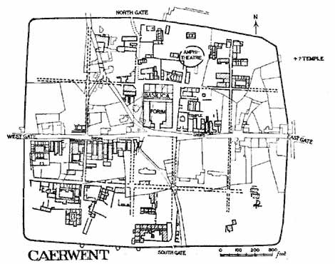
FIG. 33. CAERWENT (Reduced from plan by F. King.)
Silchester and Caerwent did not stand alone in Britain. At Wroxeter, the ancient Viroconium, tribal centre of the Cornovii and a Romano-British country-town much like Silchester, though somewhat larger, oblong 'insulae' have recently been detected by Mr. J.P. Bushe-Fox which measure 103 x 126 yds. (2-2/3 acres). At Cirencester, the Romano-British centre for the canton of the Dobuni and a still larger town than Wroxeter, the 'insulae' near the Basilica seem to have measured as much as 120 yards in length, though full details have not yet been obtained. Both these towns may be ascribed to the later years of the first century and to the same civilizing process as Silchester and Caerwent. As further Romano-British towns are uncovered, we may therefore hope for more examples. However imperfectly the inner meaning of town-planning was understood, it was plainly common in the south of Roman Britain.
NOTE. THE EASTERN PROVINCES.
To complete the survey of Roman provincial town-planning, we must glance briefly at the East. Here towns of Roman origin were few, and of those few scarcely any are well known. But they do not lack interest. For example, take Antinoê, built by Hadrian in memory of his favourite Antinous, on the banks of the Nile. It was a parallelogram more than 3 miles round, which covered an area of 360 acres. Two main streets, each colonnaded, crossed at right angles and cut it into four parts. Of the other streets, nothing certain seems to be known. But references to the town in papyri denote four quarters of it by various letters, Alpha, Beta, Gamma, Delta, and distinguish its house-blocks by the term Plintheion with a numeral attached. Thus, a house is described as lying 'in the letter Delta and the Plintheion 7'. Our documents show that there were in Antinoê at least eleven of these Plintheia.[112] It is fairly plain that they are rectangular 'insulae', of either Roman or Hellenic type, while the general fashion of the town and of its monuments suggest a Greek rather than an Italian city.
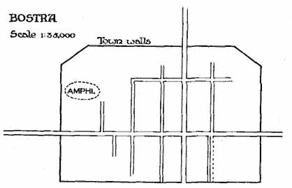
FIG. 34. BOSTRA (After Baedeker.)
Another instance may be found still further east, in the land beyond Jordan, at the capital of the Haurân, Bosrâ, anciently Bostra. Little has been achieved in the way of exploration of this site beyond studies of the stately ruins of theatres, palaces, temples, triumphal arches, aqueducts. Little can therefore be said as to the date of its ground-plan. But it was rectangular in outline, or nearly so; and its streets crossed at right angles and enclosed rectangular insulae.[113] The place owes all its greatness to Rome. During the second century it was the fortress of the Legio III Cyrenaica, which guarded this part of the eastern Roman frontier. About A.D. 225 it became a 'colonia,' and perhaps we should date from this the town-plan just described (fig. 34).
This rectangular planning remained long in use in the Eastern Empire. When in A.D. 705 (as it seems) the town of Chersonnesus in the Crimea was rebuilt after a total destruction, it was rebuilt on a symmetrical plan of oblong 'insulae' (25-30 by 60-70 yds. area). Its streets were mean and narrow. But their plan at least was apparently more regular than that of their predecessors.[114]
CHAPTER X ROMAN BUILDING-LAWS
Archaeology tells us that the western half of the Roman Empire and many districts in its eastern half used a definite town-plan which may be named, for brevity, the chess-board pattern. It remains to ask whether literature, or at least legal literature, provides any basis of theory or any ratification of the actual system which archaeology reveals. Of augural lore we have indeed enough and to spare. We know that the decumanus and the cardo, the two main lines of the Roman land-survey and probably also the two main streets of the Roman town-plan,[115] were laid out under definite augural and semi-religious provision. We should expect to find more. A system of town-planning that is so distinctive and so widely used might reasonably have created a series of building-laws sanctioning or modifying it. This did not occur. Neither the lawyers nor even the land-surveyors, the so-called Gromatici, tell us of any legal rules relative to town-planning as distinct from surveying in general. The surveyors, in particular, are much more concerned with the soil of the province and its 'limitation' and 'centuriation', than with the arrangements of any individual town, and, whatever their value for extramural boundaries,[116] throw no light on streets and 'insulae'.
The nearest approach to building-laws which occurs is a clause which seems to be a standing provision in many municipal charters and similar documents from the age of Cicero onwards, to the effect that no man might destroy, unroof, or dismantle an urban building unless he was ready to replace it by a building at least as good or had received special permission from his local town council. The earliest example of this provision occurs in the charter of the municipality of Tarentum, which was drawn up in the time of Cicero.[117] It is repeated in practically the same words in the charter of the 'colonia Genetiva' in southern Spain, which was founded in 44 B.C.; it recurs in the charter granted to the municipality of Malaga, also in southern Spain, about A.D. 82.[118] Somewhat similar prohibitions of the removal of even old and worthless houses without special leave are implied in decrees of the Roman Senate passed in A.D. 44 and A.D. 56, though these seem really to relate to rural rather than to urban buildings and were perhaps more agrarian than municipal in their object.[119] Hadrian, in a dispatch written in A.D. 127 to an eastern town which had lately obtained something like municipal status, includes a provision that a house in the town belonging to one Claudius Socrates must either be repaired by him or handed over to some other citizen.[120] Similar legislation occurs in A.D. 224 and in the time of Diocletian and later.[121]
Rules were also laid down occasionally to forbid balconies and similar structures which might impede the light and air in narrow streets, and it was a common rule that cemeteries and brickyards must lie outside the area of inhabitation. At Rome too, efforts were made by various emperors to limit the height of the large tenement houses which there formed the 'insulae'. These limits were, however, fixed haphazard without due reference to the width of the streets; they do not seem to occur outside of Rome, and even in Rome they were very scantily observed.
But in general no definite laws were framed. Probably the municipalities were somewhat closely tied in the administration of municipal property and had to refer schemes for the employment even of the smallest bit of vacant space to the 'patron' or the curator of the town. But, apart from the provisions mentioned above, they had no specific rights, that are recorded, against private owners or builders. It was only once, after Rome itself had been burnt out, that an imperial order condemned landowners who 'held up' their ground instead of using it, to forfeit their ownership in favour of any one who offered to build at once.
CHAPTER XI THE SEQUEL
What was the sequel to this long work of town-planning? Two facts stand out distinct. First, the Roman planning helped the towns of the Empire to take definite form, but when the Empire fell, it too met its end. Only here and there its vestiges lingered on in the streets of scattered cities like things of a former age. But, secondly, from this death it rose again, first in the thirteenth century, with ever-growing power to set the model for the city life of the modern world.
I. The value of town-planning to Roman civilization was twofold. It increased the comfort of the common man; it made the towns stronger and more coherent units to resist the barbarian invasions. When, after 250 years of conflict, the barbarians triumphed, its work was done. In the next age of ceaseless orderless warfare it was less fit, with its straight broad streets, for defence and for fighting than the chaos of narrow tortuous lanes out of which it had grown and to which it now returned. The cases are few in which survivals of Roman streets have conditioned the external form of mediaeval or modern towns. We in England tend perhaps to overrate the likelihood of such survivals. Our classical education has, until very lately, taught most of us more of ancient than of mediaeval history, and when our antiquaries find towns rectangular in outline and streets that cross in a Carfax, they give them a Roman origin.
Such a tendency is wrong. Plentiful evidence shows that even in Italy and even in towns where men have dwelt without a break since Roman days, the Roman streets, and with them the Roman town-plans, have far oftener vanished than endured. Rome herself, the Eternal City, uses hardly one street to-day which was used in the Roman Empire. Some few Italian towns, described in detail above, have a better claim to be called 'eternal'; half a dozen in northern Italy retain their ancient streets in singular perfection. Yet even there cities like Padua and Mantua, Genoa and Pisa, have lost the signs of their older fashion. So, too, in the provinces. In the Danubian lands only one town can even be supposed to preserve a few of its Roman streets. In all the once great cities of that region, Sirmium and Siscia, Poetovio and Celeia and Emona, they have wholly gone; you may walk across the sites to-day and seek them in vain in modern street or hedgerow or lane. In Gaul there were many Roman municipalities in the south; there were many towns of lesser rank but equal wealth in the centre and west and north. But we owe our knowledge of their town-plans to an inscription from Orange and to some excavations at Autun and Trier. Cologne and Trier alone, or almost alone, keep Roman streets in modern use, and they are significant. Both became Roman towns in the first century; both held colonial rank; both have lived on continuously ever since and hardly changed their names. Yet both bear to-day the stamp of the Middle Ages, and the Roman streets which they use are small and nearly unrecognizable fragments.
There is, indeed, no law of survivals. Chance—that convenient ancient word to denote the interaction of many imponderable forces—has ruled one way in one place and otherwise in another. Sometimes monuments have alone survived, sometimes only streets, and we can seldom give reasons for this contrast of fates. At Pola, gates, temples, and amphitheatre still tell of the Roman past and the modern town-square keeps so plainly the tradition of the Forum that you cannot walk across it without a sense of what it was. Yet not a single street agrees with those of the Roman 'colonia'. In the Lombard and Tuscan plains, at Turin and Pavia and Piacenza, at Florence and Lucca, the Roman streets are still in use, just as the old Roman field-ways still divide up the fertile plains outside those towns. But, save in Turin, hardly one Roman stone has been left upon another. In the no less fertile plain of the lower Rhone, at Nîmes and Arles and Orange, the stately ruins wake the admiration of the busiest and least learned traveller; of the Roman streets there is no sign.
Britain has enjoyed less continuity of civilization than any other western province; in Britain the survivals are even fewer. In London, within the limits of the Roman city, no street to-day follows the course of any Roman street, though Roman roads that lead up to the gates are still in use. At Colchester the Roman walls still stand; the places of the Roman gates are known; the masonry of the west gate is still visible as the masonry of a gateway. But the modern and ancient streets do not coincide, and the west gate, which has so well withstood the blows of time, can hardly be reached by road from within the city. At York the defences of the legionary fortress have still their place in the sun, but the 'colonia' on the other bank of the Ouse has vanished wholly from the surface, walls and streets together, and the houses of the citizens of Eburacum are known solely by finds of mosaic floors. At Lincoln the Roman walls and gates can easily be traced and one gate rears its arch intact, but the Bailgate alone follows, and that erratically, the line of a Roman street. The road from the Humber, thirty miles north of Lincoln, runs to-day, as it has run for eighteen centuries, under the Newport arch and through the modern town and passes on southwards. That long straight road has given a feature to Lincoln, but it is a feature due to the Roman highway outside the town, not to the streets within it. Lincoln itself is as English as Cologne and Trier are German.
II. But if Roman streets have seldom survived continuously to modern days, if Roman town-planning perished with the western Empire, it has none the less profoundly influenced the towns of mediaeval and modern Europe and America. Early in the thirteenth century men began to revive, with certain modifications, the rectangular planning which Rome had used. Perhaps copying Roman originals seen in northern Italy, Frederic Stupor Mundi now built on a chess-board pattern the Terra Nova which he founded in Sicily. Now, in 1231, Barcelonette was built with twenty square 'insulae' in south-eastern France. Now, too, the 'Bastides' and 'Villes Neuves' of southern France and towns like Aigues-Mortes (1240) were built on similar plans.[122]
FIG. 35. PLAN OF A BASTIDE TOWN, SAUVETERRE-DE-GUYENNE NEAR BORDEAUX (A.D. 1281) (By Dr. A.E. Brinckmann.)
Soon after, the chess-board pattern came to England and was used in Edwardian towns like Flint[123] and Winchelsea; then, too, it was adopted at the other end of the civilized world by German soldiers in Polish lands. Cracow, for example, owes to German settlers in the mid-thirteenth century that curious chess-board pattern of its innermost and oldest streets which so much puzzles the modern visitor.[124] It is unnecessary here to follow further the renaissance of town-planning. By intervals and revivals it continued to spread. In 1652 it reached Java, when the Dutch built Batavia. In 1682 it reached America, when Penn founded Philadelphia. In 1753, when Kandahar was refounded as a new town on a new site, its Afghan builders laid out a roughly rectangular city, divided into four quarters meeting at a central Carfax and divided further into many strangely rectangular blocks of houses.[125]
But in growing, the old town-planning has passed into a new stage. The Romans dealt with small areas, seldom more than three hundred acres and often very much less. The town-plans of the Middle Ages and even of modern times affected areas that were little larger. Only the last days have brought development. Till the enormous changes of the nineteenth century—changes which have transferred the termination of ancient history from A.D. 476 to near A.D. 1800—the older fashions remained, in town-life as in most other forms of civilized society. Towns were still, with few exceptions, small and their difficulties, if real, were simple. Save in half a dozen abnormal capitals, they had, even in relatively modern days, no vast populations to be fed and made into human and orderly citizens. They had no chemical industries, no chimneys defiling the air, or drains defiling the water. Now, builders have to face the many square miles of Chicago or Buenos Ayres, to provide lungs for their cities, to fight with polluted streams and smoke. Their problems are quite unlike those of the ancients. When Cobbett, about 1800, called London the Great Wen, he contrasted in two monosyllables the ancient ideal of a city with the ugly modern facts.
It is not, therefore, likely that modern architects or legislators will learn many hints from plans of Timgad or of Silchester. There are lessons perhaps in the growth of Turin from its little ancient chess-board to its modern enlargement, but such developments are rare. The great benefit to modern workers of such a survey as I have attempted is that it shows the slow and painful steps by which mankind became at last able to plan towns as units, yet inhabited by individual men and women, and that it emphasizes the need for definite rules and principles. Nor is it perhaps quite superfluous to-day to point out how closely, even after the great upheaval of the nineteenth century, the forms of modern life depend on the Roman world.
Footnotes: