Chapter IX · (continued 2)
Reading edition
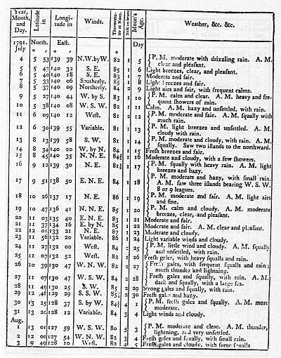
At day-light in the morning of the 25th, we made the island of Celebes, bearing from south 11° 00' east, to south 54° 00' east, distant eight or nine leagues: at noon on the 26th, the north-west point of Celebes bore south-south-east about ten leagues. This part of the coast runs down in a low point into the sea, and a little way back, rises in a round hill or hummock, but considerably lower than the back land, which is very high; from this point the land seems to take its direction about south-west by west. The latitude of the north-west point is 1° 22' north, and the longitude, by lunar observations, 121° 00' east.
On the 27th at noon the land of Celebes was distant about eight or nine leagues; between us and the southermost land in sight there was a small island. Ever since we had made the coast of Celebes we had very little wind, and that had generally been from south-east to south-west; no current was perceptible; the weather was exceedingly sultry; the freshest winds we had were from south-west; on which account, we endeavoured to get over on the Borneo shore. At four in the morning of the 29th, we had a very heavy squall from west-north-west, which obliged us to clew all up.
On the 30th, at five in the morning, we saw the island of Borneo, bearing west-north-west; this part of the coast is high land: we saw, at the same time, from the mast-head, a small island, bearing west-north-west; this I took to be one of the small islands which are laid down to the southward of the Taba Islands, and near in upon the coast: at eight in the evening, we tacked, and in the night, the wind came from the land, but squally, with which we stood to the southward. This part of the coast of Borneo seems to be a projecting point, and is in the latitude of 1° 02' north; longitude 119° 00' east.
On the 31st, at day-light, the land of Celebes bore east by north half north; we had a heavy squall of thunder, lightning, and rain.
On the 1st of September, about eight o'clock at night, when it was very dark, we suddenly discovered something on our weather quarter, which had much the appearance of a large row-boat, and there being but a very light air of wind, we prepared, with all possible silence, for the reception of a pirate; but as it did not approach us as we expected, we supposed it to have been a large tree adrift.
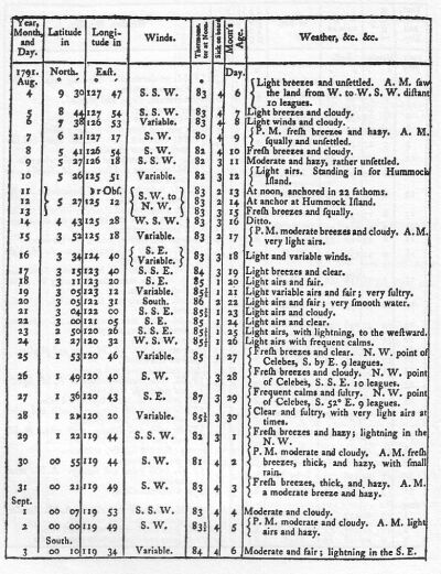
In crossing from Celebes to Borneo and back, we passed nearly over the place where seven islands are laid down in the charts, about 00° 40' to the northward of the line; but, as we saw nothing, I conclude, as Captain Carteret did, "that they exist only upon paper;" or that they may have been some of those islands which have been seen near the coast, and by an incorrect account of their situation, in point of longitude, have been placed here in mid-channel. In the morning, the Island of Celebes bore from east half north to south-south-east, and a small island covered with wood bore south-east half east, four or five miles distant. This island is in latitude 00° 03' south, longitude 119° 54' east; it lies off the opening of a large bay. On the 5th, we were in the latitude of 00° 50' south, and longitude 119 06' east, and were about six or seven leagues from the coast of Celebes; here the land near the sea is of a moderate height, but the back land is remarkably high.
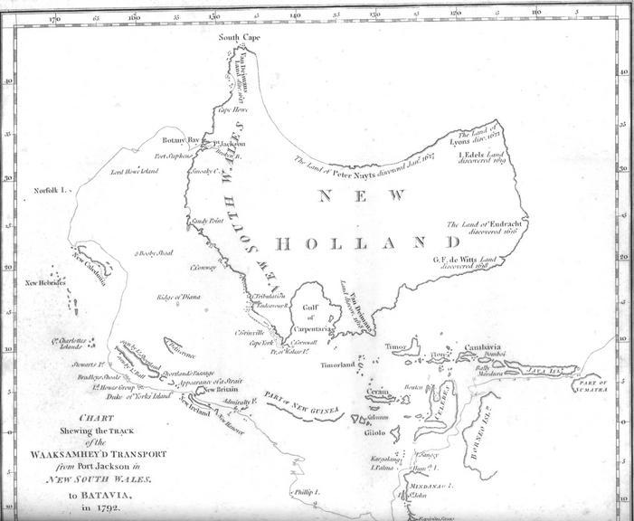
On the 7th, we saw two large proas, in the south-west; we were standing towards them, and as they were at some distance from each other, the one bore down and joined the other, and both stood for the land; we however judged it necessary to be prepared for them all the succeeding night: they might have been trading vessels, but as they can conceal their numbers, and as we knew that these seas are infested with piratical vessels of that description, it was necessary for us to be on our guard.
At noon we were in latitude 1° 47' south; longitude 118° 50' east, and no part of the Celebes shore in sight. I am convinced, from the many observations made for the longitude here, by myself, as well as by Lieutenants Bradley and Waterhouse, that the west coast of Celebes is laid down in all the charts which I have seen, much farther to the westward than it should be. On the 8th, in the evening, we were looking out for the Little Pater Nosters, being near the latitude of their north end, as determined by Captain Carteret; but although we stood to the westward all night, we saw nothing of them; I therefore suppose they lay nearer the Celebes shore than we were at this time.
On the 9th in the morning, observing the water much discoloured, we sounded, and had thirty-five fathoms over a sandy bottom; soon after, we saw, from the mast-head, a small sandy island, bearing south-west by west: at noon we were within five miles of it, and observed several shoals breaking to the northward and southward of it, with some dry patches of sand. These shoals have been taken by some for the Little Pater-Nosters, but are called by the Dutch, the Triangles; they lie in latitude 2° 58' south; longitude 117° 53' east: they are so very low, that a ship in the night would be ashore before they could be perceived; there are good soundings at some distance to the eastward of them.
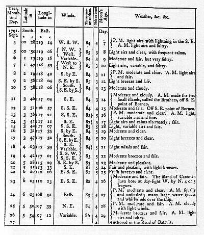
The whole time we had been in this strait, the wind had been variable from south-south-west to west-north-west; in the night it sometimes inclined in very light airs from south-south-east to south. On the 11th, in the afternoon, as we were standing to the westward, the water appeared suddenly of a very light colour, and on looking over the side, we perceived the ground under the ship: before we had time to heave a cast of the lead, it appeared to be deeper, and we had ten and twelve fathoms; but I am inclined to think, from what I saw of the bottom, that there could not have been more than five or six: the bottom was white sand, with some dark patches upon it. From the mast-head, at the same time, was seen a dry sand-bank, bearing north-north-east six miles distant; a little way to the eastward of it, the water seemed to break. This shoal is very dangerous, and does not appear in any chart which I have seen: there is a shoal marked in the Dutch charts, nearly in the same parallel, but it is so very much misplaced in its longitude, or distance from the land, that I cannot suppose it has been meant for the same shoal. The latitude of this shoal is 3° 37' south, and the longitude 117° 54' east; it extends from the two small islands which are called the Brothers, and lie off the east part of Borneo, east half north, distant fifty-one miles.
We made the Brothers at day-light in the morning, after passing this shoal, and at ten o'clock we passed within three miles of them, in from twenty-two to seventeen fathoms water, over a sandy bottom. The latitude of the Brothers is 3° 41' south, and the longitude 117° 00' east. We stood on to the south-west, after passing the Brothers, expecting that course would have carried us clear of every part of Borneo, but the south part of Borneo, and the large island called Poolo La'oot, form a considerable bight; into this bight we found a strong in-draught, by which, and the wind being light, we were drawn, and could not fetch round Borneo; we stood off and on there with light and baffling winds, and a short chop of a sea, and gained no ground: after passing two days and a night in this situation, we got a breeze, which enabled us to weather the Brothers again, and stand to the eastward, where we had more room. This situation gave me some uneasy moments; for we dropt in so fast upon the shore, that we found it necessary to prepare for anchoring; this would have occasioned a loss of time, which, from a variety of circumstances, we could not afford: the anchorage off here is clear soft ground, and shoals regularly to the shore; we had twelve fathoms four miles off. This bight ought to be carefully avoided, for certainly during the prevalence of the easterly monsoon here, there is a very strong set into it: it would be much better for ships bound to the westward to get as far to the southward as the south point of Borneo, before they stretched to the westward of the Brothers, unless they may have a fresh gale that they can depend on.
The southermost part of Borneo which we saw, lies in latitude 4° 00' south, and longitude 116° 35' east, but there is land to the southward of that, which appeared to us like two islands, on the northermost of which are two remarkable round hills; whether these are really islands, or any part of Borneo, we could not ascertain; but in all the charts the south part of Borneo is laid down farther south than that land which we at first supposed to be it, and agrees nearly with this which appeared to us like two islands, the southermost of which is in latitude 4° 15' south, and longitude 115° 16' east.
Having determined after we got out of this bight and to the eastward of the Brothers, to endeavour to get nearer the Celebes shore, and to work up on that side to the southward of 4° 00' south latitude, before we should attempt to cross the meridian of the Brothers, we stood to the eastward, and had the wind in the fore part of the day from south-south-east and south-east, and after sun-set it inclined to the south-west, but in very light airs; however, with these slants we got southing; but if ever the south-south-east breeze continued long enough to carry us in sight of the south east part of Borneo, we were then sure to be set to the northward: this having been the case, on the 15th, it obliged us to stand to the eastward, although it were an unfavourable tack.
At day-light in the morning, we tacked to the southward, and again fell in with the dry sand-bank already mentioned; we passed it at four miles distance, and had thirty-five fathoms water (to the eastward). The dry part of this sand-bank is so very small, that in bad weather the sea must break entirely over it: there is regular soundings between it and the Brothers, from twenty-five to seventeen fathoms. Being now determined not to stand farther to the westward than we could by that means gain southing, we, by the different changes of the wind, got, by the 19th, as far as 4° 42' south latitude: that morning, as we were steering to the westward, ground was discovered under the ship which of course drew every body on deck; we had ten fathoms, over a rocky bottom, which we saw very distinctly. The latitude of this ridge is 4° 35' south, and longitude, observed that morning is 117° 19' east: I judge that it must extend from some small islands, which are laid down in most of the charts, and which we supposed lay at that time directly to the southward of us, but we saw nothing of them.
From this reef we steered west-south-west, and at six in the afternoon, we saw an island bearing west half south; we hauled to the southward to weather it, and at day-light in the morning of the 20th, it bore north, distant seven leagues; its latitude is 4° 56' south, and the longitude observed that morning 115° 40' east; this we supposed to be Poolo Laut: we kept the lead going all night, and had from twenty to twenty-eight fathoms; the wind fresh from south-east by south.
We continued to steer west-south-west, and, for about fourteen leagues, we crossed a flat of sixteen fathoms. At midnight on the 21st, we saw an island bearing west-north-west three or four miles distant; this we supposed to be the island of Solombo; its latitude is 5° 42' south, and the longitude 114° 24' east. We continued to steer to the westward, and had from twenty-five to thirty-five fathoms until day-light in the morning of the 23d, when we made the islands called Cariman Java; the middle or principal one is large, and of very considerable height; it is encompassed by many smaller ones, some of which are well covered with wood: the latitude of the south side of these islands is 5° 21' south, and the longitude 110° 33' east.
On the morning of the 24th, we saw a number of water spouts and whirlwinds, some of which came so very near that we fired a few guns, in hopes that the concussion of the air would have dispersed them; but our guns were too small to give a sufficient shock to the atmosphere; however, a good breeze of wind sprung up and carried us clear of them. We steered from Cariman Java, west, and in the evening of the 25th, we made the small islands called the Boomkins, which lie about five leagues from the Coast of Java; we passed about three miles within them, and saw the shore of Java. During part of the night we steered west-north-west to avoid some sunken rocks which are laid down to the westward. The south side of the Boomkins lies in latitude 5° 56' south, and longitude 108° 21' east.
In the morning, we saw Carawang Point on Java, bearing south-south-west six or seven miles; and at five in the afternoon of the 27th, we anchored in Batavia Road, after a passage from Port Jackson of twenty-six weeks.