DESCRIPTION OF THE ISTHMUS OF TEHUANTEPEC
Reading edition
The Isthmus of Tehuantepec is a strip of land forming a low pass, which separates the mountain masses of México proper from those of Central America, and at the same time provides a continuum of lowlands from the Gulf of Mexico to the Pacific Ocean. This topography combines with the climatic conditions to create extremely diverse environments, the distribution of which can be adequately understood only after an acquaintance with the topography and climate of the region.
Physiography
In east-central Oaxaca the mountain masses comprising the Sierra Madre Oriental and the Sierra del Sur terminate in a series of ranges—Sierra de Juárez, Sierra de los Míjes, and Sierra de Choapam. From lofty peaks, such as Cerro de Zempoaltepetl (3400 meters), the highlands diminish eastward to succeedingly lower ridges, until in the middle of the Isthmus of Tehuantepec the continental divide is about 250 meters above sea level. Eastward from this low divide the land rises to form the Sierra Madre de Chiapas, which is continuous with the highland masses of Guatemala.
For the purposes of this description, the lowlands of the isthmus may be divided into three parts—the Gulf Coastal Plain, the central ridges, and the Pacific Coastal Plain, which in the isthmus is called the Plains of Tehuantepec (Figs. 1 and 2).
The Gulf Coastal Plain is broad and fairly level near the coast, but rolling in the interior. The plain, throughout most of its length in the isthmus, is at least 75 kilometers wide. The majority of the region in the isthmus is drained by the Río Coatzacoalcos, which flows in a northerly course to the Gulf of Mexico. The western part is drained by the Río San Juan, the principal tributary of the Río Papaloapan. Behind the coastal dunes are frequent, and sometimes large, lagoons. Immediately inland from Coatzacoalcos and along the lower stretches of the Río Papaloapan are extensive marshes. Essentially the entire coastal plain, with the exception of the coastal dunes, consists of rich alluvial deposits.
Fig. 1. Map of the Isthmus of Tehuantepec based on the American Geographical Society's "Map of Hispanic America on the Scale of 1:1,000,000." (Click image for larger view.) The localities shown are numbered in the gazetteer; the numerical sequence of localities is an arrangement whereby north takes precedence over south and west over east. 1. Alvarado. 2. Lerdo de Tejada. 3. Tlacotalpan. 4. Tula. 5. Tecolapan. 6. Amatitlán. 7. Cosamaloapan. 8. Chacaltianguis. 9. Novillero. 10. Ciudad Alemán. 11. Papaloapan. 12. Tuxtepec. 13. Cuatotolapam. 14. Hueyapan. 15. Berta. 16. Coatzacoalcos. 17. Ayentes. 18. Río de las Playas. 19. Cosoleacaque. 20. Minatitlán. 21. Acayucan. 22. Aquilera. 23. San Lorenzo. 24. Naranja. 25. Suchil. 26. Jesús Carranza. 27. La Oaxaqueña. 28. Ubero. 29. Donají. 30. Tolosita. 31. El Modelo. 32. Sarabia, 33. Guichicovi. 34. La Princesa. 35. Santa María Chimalapa. 36. Matías Romero. 37. Santo Domingo Petapa. 38. El Barrio. 39. Palmar. 40. Chivela. 41. Santiago Chivela. 42. Nizanda. 43. Agua Caliente. 44. Portillo Los Nanches. 45. Ixtepec. 46. La Ventosa. 47. Zanatepec. 48. Unión Hidalgo. 49. Tres Cruces. 50. Juchitán. 51. Escurano. 52. Salazar. 53. Santa Efigenia. 54. Tequisistlán. 55. Cerro de Quiengola. 56. San Pablo. 57. Mixtequilla. 58. Tapanatepec. 59. Zarzamora. 60. Limón. 61. Tehuantepec. 62. Bisilana. 63. Santa Lucía. 64. Cerro de Arenal. 65. Cerro de San Pedro. 66. La Concepción. 67. Tenango. 68. San Antonio. 69. Huilotepec. 70. Salina Cruz.
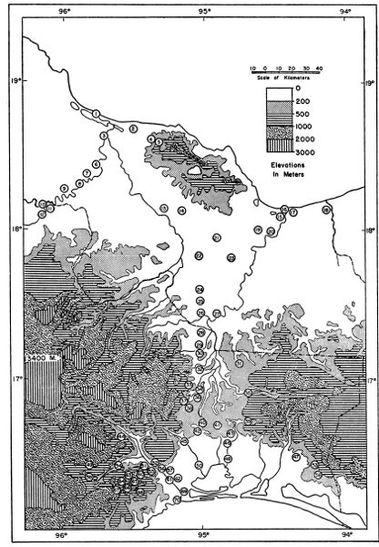
Fig. 2. Topographic profile of the Isthmus of Tehuantepec showing major localities along the Trans-isthmian Highway and major types of vegetation. Vertical exaggeration approximately 165 times.
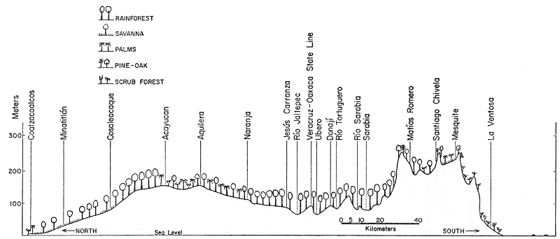
The central ridges extend from the Río Jaltepec southward to within 40 kilometers of the Pacific coast. It is in this area that the continuity of the high ridges and volcanic peaks, which extend nearly the entire length of the Americas, is interrupted at a point almost directly in line with the shortest distance between the two oceans. The northern part of this central region consists of hills dissected by tributaries of the Río Coatzacoalcos; the principal ones from north to south are—Río Jaltepec, Río Tortuguero, Río Sarabia, and Río Malatengo. The plains of Chivela are south of these rivers and lie at an elevation of about 200 meters; at the southern edge of these plains a range of hills rises to 250 to 400 meters above sea level. These hills drop abruptly to the Plains of Tehuantepec. In the northern and central parts of this central region the rocks are granitic; the hills to the south of the Plains of Chivela are limestone.
The Pacific Coastal Plain or Plains of Tehuantepec have a maximum width of about 30 kilometers. From the base of the hills at an elevation of about 75 meters the plains slope gradually to the sea. To the west of the Río Tehuantepec and to the east of the Plains of Tehuantepec at the base of the Sierra Madre de Chiapas, the coastal plain becomes much narrower; in these places the continuity of the plain is frequently interrupted by low north-south ridges extending outward from the mountains or by isolated hills. The soil is poor, varying from volcanic rock to gravel and sand.
Climate
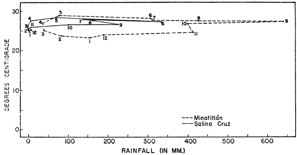
The prevailing winds are from the north across the Gulf of Mexico. These moisture-laden winds precipitate most of their moisture north of the central ridges. This results in high rainfall on the northern slopes and Gulf Coastal Plain and relatively little rainfall on the southern slopes and the Pacific Coastal Plain. Precipitation is cyclic; there is a marked wet and a dry season throughout the region, but this is most noticeable on the Pacific lowlands (Fig. 3). At Salina Cruz on the Pacific Ocean the average annual rainfall is 1040 mm. (Contreras, 1942); of this amount, only 15 mm. falls from November through April. On the Gulf Coastal Plain (Minatitlán station) the average annual rainfall is 3085 mm. In this region the driest months are February through May, during which time 236 mm. of rain falls. At Salina Cruz the wettest month is June; at Minatitlán it is September. There is little variation in temperature throughout the isthmus; the average annual temperature at Salina Cruz is 26.6° C.; that at Minatitlán is 26.2° C. During the winter when masses of air from the arctic move southward into the Great Plains of the United States, cool winds blow across the isthmus. These are usually accompanied by overcast sky and sometimes a slight amount of precipitation. These "nortes" may cause a drop in temperature of about six to eight degrees in a few hours.
Fig. 3. Climatographs for Minatitlán, Veracruz, and Salina Cruz, Oaxaca, based on data given by Contreras (1942). Plotted points are for mean monthly temperatures and rainfall; months are indicated by numbers.
Vegetation
The topography and climate combine to produce drastically different types of climax vegetation on the northern and southern lowlands of the isthmus. The picture is somewhat complicated by the savannas on the Gulf Coastal Plain, which, as will be shown later, are dependent upon edaphic features more than climatic conditions. The following brief account of the vegetation in the Isthmus of Tehuantepec is based on data provided by Williams (1939) and Goldman (1951), supplemented by personal observations. The purpose of this description is not to analyze the flora of the isthmus, but to give the reader a picture of this aspect of the biota of the major environments with which I shall be concerned in the ensuing discourse on the amphibians of the region. The three divisions of the isthmus recognized in the account of the physiography serve equally well in describing the vegetation. Those divisions are as follows:
Gulf Lowlands
On the lowlands north of the continental divide and extending to the Gulf of Mexico are three major types of vegetation—tropical rainforest, arid tropical scrub forest, and savanna. Aside from these, there are marshes and lagoons near the coast.
On the coastal dunes there are thickets of sea grape, patches of Cenchrus, and clumps or scattered Opuntia. The lagoons are bordered by mangrove thickets made up primarily of Lonchocarpus hondurensis. In the marshes along the lower Río Coatzacoalcos and Río Papaloapan the tall tough grass, Gynerium sagittatum, is common.
According to Beard (1953: 291) the development of savanna vegetation is dependent upon soil, topography, and drainage. Level regions having permeable soil horizons lying on top of an impermeable horizon provide poor drainage. In most savanna regions in the Americas the grasslands become waterlogged or even partly flooded during the rainy season and desiccated in the dry season. Many ecologists and phytogeographers have postulated that savannas are either man made or are examples of a fire climax. Beard (op. cit.: 203) provided multitudinous evidence that the association of savanna vegetation and certain types of edaphic and topographic conditions was so strongly marked that grassland is the natural vegetation in these areas.
Savannas are scattered through southern Veracruz eastward to British Honduras. These usually are grasslands having scattered trees or clumps of trees around depressions, which may contain water throughout the year (Pl. 1, fig. 1). According to Williams (op. cit.), the most common trees in the savannas in southern Veracruz are Ceiba pentandra, Chlorophora tinctoria, and Byrsonima crassifolia.
Lying in a rain shadow cast by the Tuxtlas and on sandy and well-drained soils is a dense xerophytic forest. The crown of this deciduous forest usually is little more than ten to twelve meters above the ground (Pl. 1, fig. 2). Conspicuous trees in this scrub forest are Acacia cornigera, Bauhinia latifolia, Calliandra bijuga, Cassia laevigata, Guazuma ulmifolia, and various species of Bursera.
The most extensive type of vegetation on the Gulf Coastal Plain is a tall evergreen forest resembling tropical rainforest. Although this forest is made up of many species of trees that are characteristic of true rainforest, the forest on the Gulf Coastal Plain cannot be classified as true rainforest, neither by the climatic conditions, nor the structure of the forest. The seasonal variation in rainfall probably is the chief factor in hindering the development of a rainforest climax vegetation. Usually a minimum of 65 mm. of rainfall each month is considered essential for the development of true rainforest. At Minatitlán the average rainfall for March (39 mm.) and April (36 mm.) is far below this minimum. Structurally, this forest has a crown about 30-35 meters above the ground but individual trees rising five meters or more above the crown (Pl. 2, figs. 1-2). There is no clear stratification within the forest; in many parts of it there are dense growths of bushes, small trees, and palms. The forest on the Gulf Coastal Plain, therefore, most properly might be referred to as a quasi-rainforest, a term that has been applied to other such forests in tropical America.
Among the abundant and dominant trees in this forest are Swietenia macrophylla, Calophyllum brasiliense, Achras zapota, Ceiba pentandra, Castilla elastica, Cedrela mexicana, Tabebuia Donnell-Smithi, Calocarpum mammosum, Bombax ellipticum, and a variety of Ficus. Epiphytes and Ilianas are abundant.
Central Ridges
The vegetation of the central ridges of the isthmus is, for the most part, transitional between the tall rainforest of the Gulf Coastal Plain and the low xerophytic scrub forest of the semi-arid Pacific Coastal Plain. On the northern slopes of the ridges the rainforest is more poorly developed than on the plains to the north. Many of the same species of trees are present, including Ceiba pentandra, Cedrela mexicana, Swietenia macrophylla, and Ficus sp.; nevertheless, these seldom are as large as members of the same species in the forest on the plains. Other species present on the forested slopes include Tabebuia Donnell-Smithi, Zanthoxylum melanostictum, Pithecolobium arboreum, and a species of Pterocarpus. The structure of this forest differs from that on the Gulf Coastal Plain in that there is no continuous upper canopy and there is a dense undergrowth (Pl. 3, fig.1). This type of forest extends from Mogoñe southward to about Matías Romero.
In the vicinity of Matías Romero open pine-oak forest (Pinus caribaea and Quercus sp.) is found on some ridges as low as 250 meters above sea level.
On the Plains of Chivela in the southern part of the central region the vegetation takes on a semi-arid appearance, especially in a savanna on the plains. Clumps of small trees and bushes, consisting of Croton nivea, Cordia cana, Jacquinia aurantiaca, Calycophyllum candidissimum, and Cassia emarginata, are scattered on a grassy plain, from which rise widely-spaced palms of an unknown species (Pl. 3, fig. 2).
Pacific Coastal Plain
The vegetation of the Pacific lowlands definitely is semi-arid in character. Most of the trees are deciduous, thorny, and short. During the dry season the landscape presents a barren appearance, but shortly after the first summer rains dense green foliage appears (Pl. 4, figs. 1 and 2). Between Juchitán and La Ventosa few trees are more than two meters high (Pl. 5, fig. 1). In many areas the trees and bushes form an almost impenetrable tangle, whereas on especially rocky soils or on slopes those plants are more widely spaced. Abundant and widespread species of trees on the Plains of Tehuantepec include Acacia cymbispina, Prosopis chilensis, Caesalpinia coriaria, Caesalpinia eriostachys, Celtis iguanaea, Cordia brevispicata, Jatropha aconitifolia, and Crescentia alata.
Montane Vegetation
In order to illustrate the interruption of subtropical and temperate types of vegetation by the lowlands of the Isthmus of Tehuantepec, it is necessary to digress for a moment from the isthmus and consider the types of vegetation present on the adjacent highlands. On the higher peaks, such as Cerro de Zempoaltepetl, above about 2500 meters is fir forest (Abies religiosa); lower on the slopes are extensive pine forests, which on some slopes are mixed with oak or replaced entirely by oaks. Subtropical cloud forest, characterized by relatively cool temperatures and high humidity, is found at elevations usually between 1000 and 1800 meters on the windward slopes of the Sierra Madre Oriental in Veracruz and northern Oaxaca and on the northern and southern slopes of the Chiapan-Guatemalan Highlands. None of these forest types is continuous across the Isthmus of Tehuantepec.
The Sierra de los Tuxtlas
Although actually located in the region of the Isthmus of Tehuantepec, the Sierra de los Tuxtlas, because of its isolated position, need not be considered in great detail in analyzing the distribution of animals inhabiting the lowlands of the isthmus. Nevertheless because some species living in the highlands adjacent to the isthmus also live in the Tuxtlas, this range is briefly described here. The Sierra de los Tuxtlas is a range of volcanos lying near the Gulf Coast in southern Veracruz between the mouths of the Río Papaloapan and the Río Coatzacoalcos. Volcán San Martín, the highest peak, rises above 1800 meters. This range of volcanos is surrounded by lowlands, which immediately to the south and west are covered with savanna and in places by scrub forest. The luxuriant nature of the vegetation on these volcanos indicates that this range receives much more rainfall than the surrounding lowlands. Especially on the northern slopes, tropical rainforest is well developed; this is replaced at about 1200 meters by cloud forest. The southern and western slopes are drier, for the lower slopes are covered with a scrubby, but evergreen, forest.
Detailed comments on the herpetofauna of the Tuxtlas have been omitted purposefully, for the reptiles and amphibians of the region currently are being studied by Douglas Robinson.